Conyngham Township, Columbia County, Pennsylvania

Last updated

Conyngham Township,
Columbia County,
Pennsylvania
Graffiti Highway - Centralia, Pennsylvania (2019).jpg
Abandoned portion of PA 61 in Conyngham Township from 2019 (since removed)
Map of Conyngham Township, Columbia County, Pennsylvania Highlighted.png
Map of Columbia County, Pennsylvania highlighting Conyngham Township
Map of Pennsylvania highlighting Columbia County.svg
Map of Columbia County, Pennsylvania
Country United States
State Pennsylvania
County Columbia
Settled1830
Incorporated1856
Area
[1]
  Total20.48 sq mi (53.05 km2)
  Land20.24 sq mi (52.42 km2)
  Water0.24 sq mi (0.63 km2)
Population
 (2020)
  Total689
  Estimate 
(2017) [2]
710
  Density37.94/sq mi (14.65/km2)
Time zone UTC-5 (Eastern (EST))
  Summer (DST) UTC-4 (EDT)
Area code 570
FIPS code 42-037-15880
Website https://conynghamtownship.wordpress.com/

Conyngham Township is a township in Columbia County, Pennsylvania, United States. It is part of Northeastern Pennsylvania. The population was 689 at the 2020 census. [3] Conyngham Township surrounds the famous borough of Centralia, and part of the mine fire is located here. The abandoned town of Byrnesville is located here.

Contents

Geography

Conyngham is the southernmost township in Columbia County, bordered by Northumberland County to the west and by Schuylkill County to the south and southeast. The northern boundary of the township follows the ridgecrest of Little Mountain, with a high point of 1,820 feet (550 m) above sea level. Big Mountain, also with a high point of 1820 feet, crosses the center of the township from east to west. The unincorporated community of Aristes is near the center of the township, near the summit of Big Mountain, and the communities of Wilburton Number One and Wilburton Number Two are to the west. The borough of Centralia is surrounded by the southern part of the township. The borough of Ashland in Schuylkill County is along the township's southern border, directly south of Centralia.

According to the United States Census Bureau, the township has a total area of 20.5 square miles (53.0 km2), of which 20.2 square miles (52.4 km2) is land and 0.2 square miles (0.6 km2), or 1.18%, is water. [4]

Demographics

Historical population
CensusPop.Note
2010 758
2017 (est.)710 [2] −6.3%
U.S. Decennial Census [5]

As of the census [6] of 2000, there were 792 people, 337 households, and 234 families residing in the township. The population density was 39.3 inhabitants per square mile (15.2/km2). There were 377 housing units at an average density of 18.7/sq mi (7.2/km2). The racial makeup of the township was 99.62% White, 0.13% from other races, and 0.25% from two or more races. Hispanic or Latino of any race were 0.76% of the population.

There were 337 households, out of which 26.4% had children under the age of 18 living with them, 57.0% were married couples living together, 8.6% had a female householder with no husband present, and 30.3% were non-families. 27.6% of all households were made up of individuals, and 16.6% had someone living alone who was 65 years of age or older. The average household size was 2.35 and the average family size was 2.84.

In the township the population was spread out, with 20.8% under the age of 18, 5.9% from 18 to 24, 27.4% from 25 to 44, 25.8% from 45 to 64, and 20.1% who were 65 years of age or older. The median age was 43 years. For every 100 females, there were 90.8 males. For every 100 females age 18 and over, there were 89.4 males.

The median income for a household in the township was $27,292, and the median income for a family was $35,391. Males had a median income of $29,423 versus $15,769 for females. The per capita income for the township was $14,230. About 8.9% of families and 11.0% of the population were below the poverty line, including 20.4% of those under age 18 and 7.2% of those age 65 or over.

Related Research Articles

<span class="mw-page-title-main">Columbia County, Pennsylvania</span> County in Pennsylvania, United States

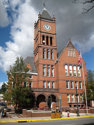
Columbia County is a county in the Commonwealth of Pennsylvania. It is located in Northeastern Pennsylvania. As of the 2020 census, the population was 64,727. Its county seat is Bloomsburg. The county was created on March 22, 1813, from part of Northumberland County. It was named Columbia, alluding to the United States and Christopher Columbus. The county is part of the Central Pennsylvania region of the state.

<span class="mw-page-title-main">Columbia Township, Bradford County, Pennsylvania</span> Township in Pennsylvania, United States

Columbia Township is a township in Bradford County, Pennsylvania, United States. It is part of Northeastern Pennsylvania. The population was 1,196 at the 2010 census. Children residing in the township are assigned to attend the Troy Area School District.

<span class="mw-page-title-main">Aristes, Pennsylvania</span> Census-designated place in Pennsylvania, United States

Aristes is a census-designated place (CDP) in Conyngham Township, Columbia County, Pennsylvania, United States. It is part of Northeastern Pennsylvania. The population was 256 at the 2020 census. It is part of the Bloomsburg-Berwick micropolitan area. Aristes is located adjacent to the famous "ghost town" of Centralia.

<span class="mw-page-title-main">Catawissa Township, Pennsylvania</span> Township in Pennsylvania, United States

Catawissa Township is a township near the borough of Catawissa, Columbia County, Pennsylvania. It is part of Northeastern Pennsylvania. The population was 904 at the 2020 census.

<span class="mw-page-title-main">North Centre Township, Pennsylvania</span> Township in Pennsylvania, United States

North Centre Township is a township in Columbia County, Pennsylvania. It is part of Northeastern Pennsylvania. The population was 2,039 at the 2020 census.

<span class="mw-page-title-main">Roaring Creek Township, Pennsylvania</span> Township in Pennsylvania, United States

Roaring Creek Township is a township in Columbia County, Pennsylvania. It is part of Northeastern Pennsylvania. The population was five hundred and forty-five at the time of the 2010 census.

<span class="mw-page-title-main">South Centre Township, Pennsylvania</span> Township in Pennsylvania, United States

South Centre Township is a township in Columbia County, Pennsylvania. It is part of Northeastern Pennsylvania. The population was 1,908 at the 2020 census.

<span class="mw-page-title-main">Wilburton Number One, Pennsylvania</span> Census-designated place in Pennsylvania, United States

Wilburton Number One is a census-designated place (CDP) in Columbia County, Pennsylvania, United States. It is part of Northeastern Pennsylvania. The population was 223 at the 2020 census. It is part of the Bloomsburg-Berwick micropolitan area.

<span class="mw-page-title-main">Wilburton Number Two, Pennsylvania</span> Census-designated place in Pennsylvania, United States

Wilburton Number Two is a census-designated place (CDP) in Columbia County, Pennsylvania, United States. It is part of Northeastern Pennsylvania. The population was 54 at the 2020 census. It is part of the Bloomsburg-Berwick micropolitan area.

<span class="mw-page-title-main">Penn Township, Lancaster County, Pennsylvania</span> Township in Pennsylvania, United States

Penn Township is a township that is located in north central Lancaster County, Pennsylvania, United States. The population was 10,224 at the time of the 2020 census.

<span class="mw-page-title-main">Conyngham, Pennsylvania</span> Borough in Pennsylvania, United States

Conyngham is a borough in Luzerne County, Pennsylvania, United States. The population was 1,820 at the 2020 census.

<span class="mw-page-title-main">Conyngham Township, Luzerne County, Pennsylvania</span> Township in Pennsylvania

Conyngham Township is a township in Luzerne County, Pennsylvania, United States. The population was 1,309 at the 2020 census.

<span class="mw-page-title-main">Delano Township, Pennsylvania</span> Township in Pennsylvania, United States

Delano Township is a township in Schuylkill County, Pennsylvania, United States. Formed in 1882 from part of Rush Township, it is named for Warren Delano Jr., maternal grandfather of Franklin Delano Roosevelt, 32nd President of the United States, 1933–1945.

<span class="mw-page-title-main">Mahanoy Township, Pennsylvania</span> Township in Pennsylvania, United States

Mahanoy Township is a township in Schuylkill County, Pennsylvania, United States. The population was 3,045 at the 2020 census.

<span class="mw-page-title-main">Reilly Township, Pennsylvania</span> Township in Pennsylvania, United States

Reilly Township is a township that is located in Schuylkill County, Pennsylvania, United States. The population was 641 at the time of the 2020 census.

<span class="mw-page-title-main">Rush Township, Schuylkill County, Pennsylvania</span> Township in Pennsylvania, United States

Rush Township is a township in Schuylkill County, Pennsylvania, United States. The population was 3,423 at the 2020 census. The township is served by Tamaqua Area School District and Mahanoy Area School District.

<span class="mw-page-title-main">Heidelberg Township, York County, Pennsylvania</span> Township in Pennsylvania, United States

Heidelberg Township is a township in York County, Pennsylvania, United States. The township was erected in 1750 and encompassed the land grant known as Digges' Choice, a warrant granted to John Digges in 1727 by the colonial-era Province of Maryland, prior to the time the Mason-Dixon line fixed the final boundary between Maryland and Pennsylvania. The population of Heidelberg Township was 3,027 at the 2020 census.

<span class="mw-page-title-main">North Codorus Township, Pennsylvania</span> Township in Pennsylvania, United States

North Codorus Township is a township in York County, Pennsylvania, United States. The population was 9,149 at the 2020 census.

<span class="mw-page-title-main">North Hopewell Township, Pennsylvania</span> Township in Pennsylvania, United States

North Hopewell Township is a township that is located in York County, Pennsylvania, United States. The population was 2,723 at the time of the 2020 census.

<span class="mw-page-title-main">Ashland, Pennsylvania</span> Borough in Pennsylvania, United States

Ashland is a borough in Schuylkill County in the U.S. state of Pennsylvania, 15 miles (24 km) northwest of Pottsville. It is part of Northeastern Pennsylvania. A small part of the borough also lies in Columbia County, although all of the population resided in the Schuylkill County portion as of the 2020 census. The borough lies in the anthracite coal region of eastern Pennsylvania. Settled in 1850, Ashland was incorporated in 1857, and was named for Henry Clay's estate near Lexington, Kentucky. The population in 1900 was 6,438, and in 1940, 7,045, but had dropped to 2,471 at the 2020 census.

References

  1. "2016 U.S. Gazetteer Files". United States Census Bureau. Retrieved August 13, 2017.
  2. 1 2 "U.S. Census website". United States Census Bureau . Retrieved August 4, 2019.
  3. "Explore Census Data". data.census.gov. Retrieved December 11, 2021.
  4. "Geographic Identifiers: 2010 Census Summary File 1 (G001): Conyngham township, Columbia County, Pennsylvania". U.S. Census Bureau, American Factfinder. Archived from the original on February 13, 2020. Retrieved May 21, 2015.
  5. "Census of Population and Housing". Census.gov. Retrieved June 4, 2016.
  6. Bureau, U. S. Census. "U.S. Census website". United States Census Bureau . Retrieved August 4, 2019.

40°50′00″N76°22′35″W / 40.83333°N 76.37639°W / 40.83333; -76.37639