Sparks is a city in Washoe County, Nevada, United States. It was founded in 1904, incorporated on March 15, 1905, and is located just east of Reno. The 2020 U.S. Census counted 108,445 residents in the city. It is the fifth most populous city in Nevada. It is named after John Sparks, Nevada Governor (1903–1908), and a member of the Silver Party.

Stormwater, also written storm water, is water that originates from precipitation (storm), including heavy rain and meltwater from hail and snow. Stormwater can soak into the soil (infiltrate) and become groundwater, be stored on depressed land surface in ponds and puddles, evaporate back into the atmosphere, or contribute to surface runoff. Most runoff is conveyed directly as surface water to nearby streams, rivers or other large water bodies without treatment.

Water pollution is the contamination of water bodies, usually as a result of human activities, so that it negatively affects its uses. Water bodies include lakes, rivers, oceans, aquifers, reservoirs and groundwater. Water pollution results when contaminants mix with these water bodies. Contaminants can come from one of four main sources: sewage discharges, industrial activities, agricultural activities, and urban runoff including stormwater. Water pollution is either surface water pollution or groundwater pollution. This form of pollution can lead to many problems, such as the degradation of aquatic ecosystems or spreading water-borne diseases when people use polluted water for drinking or irrigation. Another problem is that water pollution reduces the ecosystem services that the water resource would otherwise provide.

Pyramid Lake is the geographic sink of the basin of the Truckee River, 40 mi (64 km) northeast of Reno, Nevada, United States.
The Truckee–Carson Irrigation District (TCID) is a political subdivision of the State of Nevada, which operates dams at Lake Tahoe, diversion dams on the Truckee River in Washoe County, and the Lake Lahontan reservoir.
The cui-ui is a large sucker fish endemic to Pyramid Lake and, prior to its desiccation in the 20th century, Winnemucca Lake in northwestern Nevada. It feeds primarily on zooplankton and possibly on nanoplankton. The maximum size of male cui-ui is approximately 53 cm (21 in) and 1.6 kg (3.5 lb), while females reach approximately 64 cm (25 in) and 2.7 kg (6.0 lb). A cui-ui typically lives for 40 years but do not reach sexual maturity until at least age eight. The cui-ui is an endangered species, and one of the few surviving members of its genus.

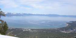
The Truckee River is a river in the U.S. states of California and Nevada. The river flows northeasterly and is 121 miles (195 km) long. The Truckee is the sole outlet of Lake Tahoe and drains part of the high Sierra Nevada, emptying into Pyramid Lake in the Great Basin. Its waters are an important source of irrigation along its valley and adjacent valleys.

The Clean Water Act (CWA) is the primary federal law in the United States governing water pollution. Its objective is to restore and maintain the chemical, physical, and biological integrity of the nation's waters; recognizing the responsibilities of the states in addressing pollution and providing assistance to states to do so, including funding for publicly owned treatment works for the improvement of wastewater treatment; and maintaining the integrity of wetlands.

Lahontan cutthroat trout is the largest subspecies of cutthroat trout, and the state fish of Nevada. It is one of three subspecies of cutthroat trout that are listed as federally threatened.

Surface runoff is the unconfined flow of water over the ground surface, in contrast to channel runoff. It occurs when excess rainwater, stormwater, meltwater, or other sources, can no longer sufficiently rapidly infiltrate in the soil. This can occur when the soil is saturated by water to its full capacity, and the rain arrives more quickly than the soil can absorb it. Surface runoff often occurs because impervious areas do not allow water to soak into the ground. Furthermore, runoff can occur either through natural or human-made processes.
The tui chub is a cyprinid fish native to western North America. Widespread in many areas, it is an important food source for other fish, including the cutthroat trout.

An hydrological transport model is a mathematical model used to simulate the flow of rivers, streams, groundwater movement or drainage front displacement, and calculate water quality parameters. These models generally came into use in the 1960s and 1970s when demand for numerical forecasting of water quality and drainage was driven by environmental legislation, and at a similar time widespread access to significant computer power became available. Much of the original model development took place in the United States and United Kingdom, but today these models are refined and used worldwide.
Total dissolved solids (TDS) is a measure of the dissolved combined content of all inorganic and organic substances present in a liquid in molecular, ionized, or micro-granular suspended form. TDS are often measured in parts per million (ppm). TDS in water can be measured using a digital meter.
A total maximum daily load (TMDL) is a regulatory term in the U.S. Clean Water Act, describing a plan for restoring impaired waters that identifies the maximum amount of a pollutant that a body of water can receive while still meeting water quality standards.

Best management practices (BMPs) is a term used in the United States and Canada to describe a type of water pollution control. Historically the term has referred to auxiliary pollution controls in the fields of industrial wastewater control and municipal sewage control, while in stormwater management and wetland management, BMPs may refer to a principal control or treatment technique as well.

Urban runoff is surface runoff of rainwater, landscape irrigation, and car washing created by urbanization. Impervious surfaces are constructed during land development. During rain, storms, and other precipitation events, these surfaces, along with rooftops, carry polluted stormwater to storm drains, instead of allowing the water to percolate through soil. This causes lowering of the water table and flooding since the amount of water that remains on the surface is greater. Most municipal storm sewer systems discharge untreated stormwater to streams, rivers, and bays. This excess water can also make its way into people's properties through basement backups and seepage through building wall and floors.

Nutrient pollution, a form of water pollution, refers to contamination by excessive inputs of nutrients. It is a primary cause of eutrophication of surface waters, in which excess nutrients, usually nitrogen or phosphorus, stimulate algal growth. Sources of nutrient pollution include surface runoff from farm fields and pastures, discharges from septic tanks and feedlots, and emissions from combustion. Raw sewage is a large contributor to cultural eutrophication since sewage is high in nutrients. Releasing raw sewage into a large water body is referred to as sewage dumping, and still occurs all over the world. Excess reactive nitrogen compounds in the environment are associated with many large-scale environmental concerns. These include eutrophication of surface waters, harmful algal blooms, hypoxia, acid rain, nitrogen saturation in forests, and climate change.

Water pollution in the United States is a growing problem that became critical in the 19th century with the development of mechanized agriculture, mining, and industry, although laws and regulations introduced in the late 20th century have improved water quality in many water bodies. Extensive industrialization and rapid urban growth exacerbated water pollution as a lack of regulation allowed for discharges of sewage, toxic chemicals, nutrients and other pollutants into surface water.
Water quality modeling involves water quality based data using mathematical simulation techniques. Water quality modeling helps people understand the eminence of water quality issues and models provide evidence for policy makers to make decisions in order to properly mitigate water. Water quality modeling also helps determine correlations to constituent sources and water quality along with identifying information gaps. Due to the increase in freshwater usage among people, water quality modeling is especially relevant both in a local level and global level. In order to understand and predict the changes over time in water scarcity, climate change, and the economic factor of water resources, water quality models would need sufficient data by including water bodies from both local and global levels.

Point source water pollution comes from discrete conveyances and alters the chemical, biological, and physical characteristics of water. In the United States, it is largely regulated by the Clean Water Act (CWA). Among other things, the Act requires dischargers to obtain a National Pollutant Discharge Elimination System (NPDES) permit to legally discharge pollutants into a water body. However, point source pollution remains an issue in some water bodies, due to some limitations of the Act. Consequently, other regulatory approaches have emerged, such as water quality trading and voluntary community-level efforts.