Deglaciation

Last updated

Deglaciation is the transition from full glacial conditions during ice ages, to warm interglacials, characterized by global warming and sea level rise due to change in continental ice volume. [1] Thus, it refers to the retreat of a glacier, an ice sheet or frozen surface layer, and the resulting exposure of the Earth's surface. The decline of the cryosphere due to ablation can occur on any scale from global to localized to a particular glacier. [2] After the Last Glacial Maximum (ca. 21,000 years ago), the last deglaciation begun, which lasted until the early Holocene. [3] [4] Around much of Earth, deglaciation during the last 100 years has been accelerating as a result of climate change, partly brought on by anthropogenic changes to greenhouse gases. [5]

Contents

The previous deglaciation took place from approximately 22  ka until 11.5 ka. This occurred when there was an annual mean atmospheric temperature on the earth that increased by roughly 5 °C, which was also accompanied by regional high-latitude warming that exceeded 10 °C. This was also followed by noteworthy deep-sea and tropical-sea warming, of about 1–2 °C (deep-sea) and 2–4 °C (tropical sea). Not only did this warming occur, but the global hydrological budget also experienced noticeable changes and regional precipitation patterns changed. As a result of all of this, the world's main ice sheets, including the ones located in Eurasia, North America and parts of the Antarctic melted. As a consequence, sea levels rose roughly 120 metres. These processes did not occur steadily, and they also did not occur at the same time. [4]

Background

The process of deglaciation reflects a lack of balance between existing glacial extent and climatic conditions. As a result of net negative mass balance over time, glaciers and ice sheets retreat. The repeated periods of increased and decreased extent of the global cryosphere (as deduced from observations of ice and rock cores, surface landforms, sub-surface geologic structures, the fossil record, and other methods of dating) reflect the cyclical nature of global and regional glaciology measured by ice ages and smaller periods known as glacials and interglacials. [6] [7] Since the end of the Last glacial period about 12,000 years ago, ice sheets have retreated on a global scale, and Earth has been experiencing a relatively warm interglacial period marked by only high-altitude alpine glaciers at most latitudes with larger ice sheet and sea ice at the poles. [8] However, since the onset of the Industrial Revolution, human activity has contributed to a rapid increase in the speed and scope of deglaciation globally. [9] [10]

Greenland

Research published in 2014 suggests that below Greenland's Russell Glacier's ice sheet, methanotrophs could serve as a biological methane sink for the subglacial ecosystem, and the region was at least during the sample time, a source of atmospheric methane. Based on dissolved methane in water samples, Greenland may represent a significant global methane source, and may contribute significantly more due to ongoing deglaciation. [11] A study in 2016 concluded based on past evidence, that below Greenland's and Antarctica's ice sheet may exist methane clathrates. [12]

Causes and effects

At every scale, climate influences the condition of snow and ice on Earth's surface. In colder periods massive ice sheets may extend toward the Equator, while in periods warmer than today, the Earth may be completely free of ice. A significant, empirically demonstrated, positive relationship exists between the surface temperature and concentration of Greenhouse gases such as CO2 in the atmosphere. The higher concentration, in turn, has a drastic negative impact on the global extent and stability of the cryosphere. [13] [14] On the millennial time scales of Pleistocene glacial and interglacial cycles, the pacemaker of glaciation onset and melting are changes in orbital parameters termed the Milankovitch cycles. Specifically, low summer insolation in the northern hemisphere permits growth of ice sheets, while high summer insolation causes more ablation than winter snow accumulation.

Human activities promoting climate change, notably the extensive use of fossil fuels over the last 150 years and the resulting increase in atmospheric CO2 concentrations, are the principal cause of the more rapid retreat of alpine glaciers and continental ice sheets all across the world. [9] For example, the West Antarctic Ice Sheet has receded significantly, and is now contributing to a positive feedback loop that threatens further deglaciation or collapse. Newly exposed areas of the Southern Ocean contain long-sequestered stores of CO2 which are now being emitted into the atmosphere and are continuing to impact glacial dynamics. [14]

The principle of isostasy applies directly to the process of deglaciation, especially post-glacial rebound, which is one of main mechanisms through which isostasy is observed and studied. Post-glacial rebound refers to the increase in tectonic uplift activity immediately following glacial retreat. [15] Increased rates and abundance of volcanic activity have been found in regions experiencing post-glacial rebound. If on a large enough scale, an increase in volcanic activity provides a positive feedback to the process of deglaciation as a result CO2 and methane released from volcanos. [16] [17]

Periods of deglaciation are also caused in part by oceanic processes. [18] For example, interruptions of the usual deep cold water circulation and penetration depths in the North Atlantic have feedbacks that promote further glacial retreat. [19]

Deglaciation influences sea level because water previously held on land in solid form turns into liquid water and eventually drains into the ocean. The recent period of intense deglaciation has resulted in an average global sea level rise of 1.7 mm/year for the entire 20th century, and 3.2 mm/year over the past two decades, a very rapid increase. [20]

The physical mechanisms by which deglaciation occurs include melting, evaporation, sublimation, calving, and aeolian processes such as wind scouring.

Deglaciation of the Laurentide Ice Sheet

Throughout the Pleistocene Epoch, the Laurentide Ice Sheet spread over large areas of northern North America, with over 5,000,000 square miles of coverage. The Laurentide ice sheet was 10,000 feet deep in some areas, and reached as far south as 37°N. Mapped extent of the Laurentide Ice Sheet during deglaciation has been prepared by Dyke et al. [21] Cycles of deglaciation are driven by various factors, with the main driver being changes in incoming summer solar radiation, or insolation, in the Northern Hemisphere. But, as not all of the rises in insolation throughout time caused deglaciation, to the current ice volumes that we witness today. This leads to a different conclusion, one that suggests that there is a possible climatic threshold, in terms of ice sheets retreating, and eventually disappearing. As Laurentide was the largest mass ice sheet in the Northern Hemisphere, much study has been conducted regarding its disappearance, unloading energy balance models, atmosphere-ocean general circulation models, and surface energy balance models. These studies concluded that the Laurentide ice sheet presented a positive surface mass balance during almost the entirety of its deglaciation, which indicates that the loss of mass throughout its deglaciation was more than likely due to dynamic discharge. It was not until the early Holocene when the surface mass balance switched to become negative. This change to a negative surface mass balance suggested that surface ablation became the driver that resulted in the loss of mass of ice in the Laurentide ice sheet. It is concluded then that the Laurentide ice sheet only began to exhibit behaviours and patterns of deglaciation after radiative forcing and summer temperatures began to rise at the beginning of the Holocene. [22]

Result of the deglaciation of the Laurentide ice sheet

When the Laurentide ice sheet progressed through the process of deglaciation, it created many new landforms and had various effects of the land. First and foremost, as huge glaciers melt, there is a consequently large volume of meltwater. The volumes of meltwater created many features, including proglacial freshwater lakes, which can be sizable. Not only was there meltwater that formed lakes, there were also storms that blew over the inland freshwater. These storms created waves strong enough to erode the ice shores. Once ice cliffs were exposed, due to rising sea levels and erosion caused by waves, the ice bergs were split and shed (calved) off. Large lakes became prevalent, but so did smaller, shallower, relatively short-lived lakes. This appearance and disappearance of small, shallow lakes influenced much of the plant growth, spread and diversity that we see today. The lakes acted as barriers to plant migration, but when these lakes drained, the plants could migrate and spread very efficiently. [23]

The last deglaciation

Temperature from 20,000 to 10,000 years ago, derived from EPICA Dome C Ice Core (Antarctica) 20191021 Temperature from 20,000 to 10,000 years ago - recovery from ice age.png
Temperature from 20,000 to 10,000 years ago, derived from EPICA Dome C Ice Core (Antarctica)
The Post-Glacial Sea Level Post-Glacial Sea Level.png
The Post-Glacial Sea Level

The period between the end of the Last Glacial Maximum to the early Holocene (ca. 19k-11k years ago), shows changes in greenhouse gas concentrations and of the Atlantic meridional overturning circulation (AMOC), when sea-level rose by 80 meters. [4] Additionally, the last deglaciation is marked by three abrupt CO2 pulses, [24] and records of volcanic eruptions show that subaerial volcanism increased globally by two to six times above background levels between 12 ka and 7 ka. [25]

Between roughly 19ka, the end of the Last Glacial Maximum (or LGM) to 11ka, which was the early Holocene, the climate system experienced drastic transformation. Much of this change was occurring at an astonishing rate, as the earth was dealing with the end of the last ice age. Changes in insolation was the principal reason for this drastic global change in climate, as this was linked with several other changes globally, from the alteration of ice sheets, to the concentration of greenhouse gases fluctuating, and many other feedbacks that resulted in distinct responses, both globally and regionally. Not only were ice sheets and greenhouse gases experiencing alteration, but also additionally to this, there was sudden climate change, and many occurrences of fast, and sizeable rising of sea level. The melting of the ice sheets, along with the rising sea levels did not happen until after 11ka. Nonetheless, the globe had arrived at its present interglacial period, where climate is comparatively constant and stable, and greenhouse gas concentrations exhibit near pre-industrial levels. This data is all available due to studies and information gathered from proxy records, both from the terrestrial and ocean, which illustrates overall global patterns of changes in climate whilst in the period of Deglaciation. [4]

During the Last Glacial Maximum (LGM), there were apparent low atmospheric concentration of Carbon Dioxide (CO2), which was believed to be as a result of larger containment of carbon in the deep ocean, via the process of stratification within the Southern Ocean. These Southern Ocean deep waters contained the least δ13C, which consequently resulted in them being the location with the greatest density, and most salt content during the LGM. The discharge of such sequestered carbon was perhaps a direct outcome of the deep Southern Ocean overturning, driven by heightened wind-driven upwelling, and sea-ice retreat, which are directly correlated to the warming of the Antarctic, and also coinciding with the cold events, the Oldest and Younger Dryas, in the north. [4]

Throughout the LGM in North America, the east was populated by cold-tolerant conifer forests, while the southeast and northwest of the United States sustained open forests in locations that have closed forests today, which suggests that during the LGM temperatures were cooler and overall conditions were much drier than those that we experience today. There is also indication that the southwest of the United States was much wetter during the LGM compared to today, as there was open forest, where today we see desert and steppe. In the United States, the general variation of vegetation implies an overall fall in temperatures of (at minimum 5 °C), a shift of the westerly storm tracks to the south, and a very steep latitudinal temperature gradient. [4]

Landforms

Several landforms visible today are distinctive of the powerful erosional forces at play during, or immediately after, deglaciation. The distribution of such landforms helps to inform the understanding of the glacial dynamics and geologic periods of the past. Studying exposed landforms can also inform the understanding of the present and near future as glaciers all over the world retreat in the current period of climate change. [26] In general, recently deglacialized landscapes are inherently unstable and will tend to move towards an equilibrium. [27]

A sampling of common landforms caused by deglaciation, or caused by the successive geomorphic processes after exposure due to deglaciation:

See also

Related Research Articles

<span class="mw-page-title-main">Ice age</span> Period of long-term reduction in temperature of Earths surface and atmosphere

An ice age is a long period of reduction in the temperature of Earth's surface and atmosphere, resulting in the presence or expansion of continental and polar ice sheets and alpine glaciers. Earth's climate alternates between ice ages and greenhouse periods, during which there are no glaciers on the planet. Earth is currently in the ice age called Quaternary glaciation. Individual pulses of cold climate within an ice age are termed glacial periods, and intermittent warm periods within an ice age are called interglacials or interstadials.

<span class="mw-page-title-main">Pleistocene</span> First epoch of the Quaternary Period

The Pleistocene is the geological epoch that lasted from c. 2.58 million to 11,700 years ago, spanning the Earth's most recent period of repeated glaciations. Before a change was finally confirmed in 2009 by the International Union of Geological Sciences, the cutoff of the Pleistocene and the preceding Pliocene was regarded as being 1.806 million years Before Present (BP). Publications from earlier years may use either definition of the period. The end of the Pleistocene corresponds with the end of the last glacial period and also with the end of the Paleolithic age used in archaeology. The name is a combination of Ancient Greek πλεῖστος (pleîstos), meaning "most", and καινός, meaning "new".

<span class="mw-page-title-main">Snowball Earth</span> Worldwide glaciation episodes during the Proterozoic eon

The Snowball Earth is a geohistorical hypothesis that proposes during one or more of Earth's icehouse climates, the planet's surface became entirely or nearly entirely frozen with no liquid oceanic or surface water exposed to the atmosphere. The most academically referred period of such global glaciation is believed to have occurred sometime before 650 mya during the Cryogenian period.

<span class="mw-page-title-main">Climate variability and change</span> Change in the statistical distribution of climate elements for an extended period

Climate variability includes all the variations in the climate that last longer than individual weather events, whereas the term climate change only refers to those variations that persist for a longer period of time, typically decades or more. Climate change may refer to any time in Earth's history, but the term is now commonly used to describe contemporary climate change, often popularly referred to as global warming. Since the Industrial Revolution, the climate has increasingly been affected by human activities.

<span class="mw-page-title-main">Cryosphere</span> Those portions of Earths surface where water is in solid form

The cryosphere is an all-encompassing term for the portions of Earth's surface where water is in solid form, including sea ice, lake ice, river ice, snow cover, glaciers, ice caps, ice sheets, and frozen ground. Thus, there is a wide overlap with the hydrosphere. The cryosphere is an integral part of the global climate system with important linkages and feedbacks generated through its influence on surface energy and moisture fluxes, clouds, precipitation, hydrology, atmospheric and oceanic circulation.

<span class="mw-page-title-main">Last Glacial Period</span> Period of major glaciations of the northern hemisphere (115,000–12,000 years ago)

The Last Glacial Period (LGP), also known colloquially as the Last Ice Age or simply Ice Age, occurred from the end of the Eemian to the end of the Younger Dryas, encompassing the period c. 115,000 – c. 11,700 years ago.

<span class="mw-page-title-main">Post-glacial rebound</span> Rise of land masses after glacial period

Post-glacial rebound is the rise of land masses after the removal of the huge weight of ice sheets during the last glacial period, which had caused isostatic depression. Post-glacial rebound and isostatic depression are phases of glacial isostasy, the deformation of the Earth's crust in response to changes in ice mass distribution. The direct raising effects of post-glacial rebound are readily apparent in parts of Northern Eurasia, Northern America, Patagonia, and Antarctica. However, through the processes of ocean siphoning and continental levering, the effects of post-glacial rebound on sea level are felt globally far from the locations of current and former ice sheets.

A glacial period is an interval of time within an ice age that is marked by colder temperatures and glacier advances. Interglacials, on the other hand, are periods of warmer climate between glacial periods. The Last Glacial Period ended about 15,000 years ago. The Holocene is the current interglacial. A time with no glaciers on Earth is considered a greenhouse climate state.

<span class="mw-page-title-main">Last Glacial Maximum</span> Most recent time during the Last Glacial Period that ice sheets were at their greatest extent

The Last Glacial Maximum (LGM), also referred to as the Last Glacial Coldest Period, was the most recent time during the Last Glacial Period that ice sheets were at their greatest extent 26,000 and 20,000 years ago. Ice sheets covered much of Northern North America, Northern Europe, and Asia and profoundly affected Earth's climate by causing a major expansion of deserts, along with a large drop in sea levels.

<span class="mw-page-title-main">Global temperature record</span> Fluctuations of the Earths temperature over time

The global temperature record shows the fluctuations of the temperature of the atmosphere and the oceans through various spans of time. There are numerous estimates of temperatures since the end of the Pleistocene glaciation, particularly during the current Holocene epoch. Some temperature information is available through geologic evidence, going back millions of years. More recently, information from ice cores covers the period from 800,000 years before the present time until now. A study of the paleoclimate covers the time period from 12,000 years ago to the present. Tree rings and measurements from ice cores can give evidence about the global temperature from 1,000-2,000 years before the present until now. The most detailed information exists since 1850, when methodical thermometer-based records began. Modifications on the Stevenson-type screen were made for uniform instrument measurements around 1880.

The Bølling–Allerød interstadial, also called the Late Glacial Interstadial, was an abrupt warm and moist interstadial period that occurred during the final stages of the Last Glacial Period. This warm period ran from 14,690 to 12,890 years before the present (BP). It began with the end of the cold period known as the Oldest Dryas, and ended abruptly with the onset of the Younger Dryas, a cold period that reduced temperatures back to near-glacial levels within a decade.

<span class="mw-page-title-main">Quaternary glaciation</span> Series of alternating glacial and interglacial periods

The Quaternary glaciation, also known as the Pleistocene glaciation, is an alternating series of glacial and interglacial periods during the Quaternary period that began 2.58 Ma and is ongoing. Although geologists describe this entire period up to the present as an "ice age", in popular culture this term usually refers to the most recent glacial period, or to the Pleistocene epoch in general. Since Earth still has polar ice sheets, geologists consider the Quaternary glaciation to be ongoing, though currently in an interglacial period.

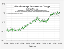
The Holocene glacial retreat is a geographical phenomenon that involved the global retreat of glaciers (deglaciation) that previously had advanced during the Last Glacial Maximum. Ice sheet retreat initiated ca. 19,000 years ago and accelerated after ca. 15,000 years ago. The Holocene, starting with abrupt warming 11,700 years ago, resulted in rapid melting of the remaining ice sheets of North America and Europe.

<span class="mw-page-title-main">Marine Isotope Stage 11</span> Marine isotope stage between 424,000 and 374,000 years ago

Marine Isotope Stage 11 or MIS 11 is a Marine Isotope Stage in the geologic temperature record, covering the interglacial period between 424,000 and 374,000 years ago. It corresponds to the Hoxnian Stage in Britain.

The Antarctic Cold Reversal (ACR) was an important episode of cooling in the climate history of the Earth during the deglaciation at the close of the last ice age. It illustrates the complexity of the climate changes at the transition from the Pleistocene to the Holocene Epochs.

Throughout Earth's climate history (Paleoclimate) its climate has fluctuated between two primary states: greenhouse and icehouse Earth. Both climate states last for millions of years and should not be confused with glacial and interglacial periods, which occur as alternate phases within an icehouse period and tend to last less than 1 million years. There are five known Icehouse periods in Earth's climate history, which are known as the Huronian, Cryogenian, Andean-Saharan, Late Paleozoic, and Late Cenozoic glaciations. The main factors involved in changes of the paleoclimate are believed to be the concentration of atmospheric carbon dioxide, changes in Earth's orbit, long-term changes in the solar constant, and oceanic and orogenic changes from tectonic plate dynamics. Greenhouse and icehouse periods have played key roles in the evolution of life on Earth by directly and indirectly forcing biotic adaptation and turnover at various spatial scales across time.

<span class="mw-page-title-main">Ice-sheet dynamics</span> Technical explanation of ice motion within large bodies of ice

Ice sheet dynamics describe the motion within large bodies of ice such as those currently on Greenland and Antarctica. Ice motion is dominated by the movement of glaciers, whose gravity-driven activity is controlled by two main variable factors: the temperature and the strength of their bases. A number of processes alter these two factors, resulting in cyclic surges of activity interspersed with longer periods of inactivity, on both hourly and centennial time scales. Ice-sheet dynamics are of interest in modelling future sea level rise.

<span class="mw-page-title-main">Weichselian glaciation</span> Last glacial period and its associated glaciation in northern parts of Europe

The Weichselian glaciation was the last glacial period and its associated glaciation in northern parts of Europe. In the Alpine region it corresponds to the Würm glaciation. It was characterized by a large ice sheet that spread out from the Scandinavian Mountains and extended as far as the east coast of Schleswig-Holstein, northern Poland and Northwest Russia. This glaciation is also known as the Weichselian ice age, Vistulian glaciation, Weichsel or, less commonly, the Weichsel glaciation, Weichselian cold period (Weichsel-Kaltzeit), Weichselian glacial (Weichsel-Glazial), Weichselian Stage or, rarely, the Weichselian complex (Weichsel-Komplex).

<span class="mw-page-title-main">Past sea level</span> Sea level variations over geological time scales

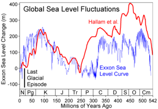
Global or eustatic sea level has fluctuated significantly over Earth's history. The main factors affecting sea level are the amount and volume of available water and the shape and volume of the ocean basins. The primary influences on water volume are the temperature of the seawater, which affects density, and the amounts of water retained in other reservoirs like rivers, aquifers, lakes, glaciers, polar ice caps and sea ice. Over geological timescales, changes in the shape of the oceanic basins and in land/sea distribution affect sea level. In addition to eustatic changes, local changes in sea level are caused by tectonic uplift and subsidence.

<span class="mw-page-title-main">Early Holocene sea level rise</span> Sea level rise between 12,000 and 7,000 years ago

The early Holocene sea level rise (EHSLR) was a significant jump in sea level by about 60 m (197 ft) during the early Holocene, between about 12,000 and 7,000 years ago, spanning the Eurasian Mesolithic. The rapid rise in sea level and associated climate change, notably the 8.2 ka cooling event , and the loss of coastal land favoured by early farmers, may have contributed to the spread of the Neolithic Revolution to Europe in its Neolithic period.

References

  1. IPCC AR5 (2013). "Climate Change 2013: The Physical Science Basis - Annex III: Glossary" (PDF). Archived from the original (PDF) on 2016-05-24. Retrieved 2015-05-15.
  2. International Association of Cryospheric Sciences (2011). "Glossary of glacier mass balance and related terms". UNESCO Digital Library. Retrieved 2021-02-08.
  3. IPCC (2007). "What Do the Last Glacial Maximum and the Last Deglaciation Show?". Archived from the original on 2015-04-25. Retrieved 2015-05-14.
  4. 1 2 3 4 5 6 Clark; et al. (2011). "Global climate evolution during the last deglaciation". PNAS. 109 (19): E1134–E1142. doi: 10.1073/pnas.1116619109 . PMC   3358890 . PMID   22331892.
  5. "Glaciers and Climate Change". NSIDC. National Snow & Ice Data Center. 2017. Retrieved 1 June 2017.
  6. Jiménez-Sánchez, M.; et al. (2013). "A review of glacial geomorphology and chronology in northern Spain: Timing and regional variability during the last glacial cycle". Geomorphology. 196: 50–64. Bibcode:2013Geomo.196...50J. doi:10.1016/j.geomorph.2012.06.009. hdl: 10261/82429 .
  7. Bentley M.J. (2009). "The Antarctic palaeo record and its role in improving predictions of future Antarctic Ice Sheet change" (PDF). Journal of Quaternary Science. 25 (1): 5–18. doi:10.1002/jqs.1287. S2CID   130012058.
  8. Carlson A.E., Clark P.U. (2012). "Ice sheet sources of sea level rise and freshwater discharge during the last deglaciation". Reviews of Geophysics. 50 (4): 4. Bibcode:2012RvGeo..50.4007C. doi:10.1029/2011RG000371. S2CID   130770580.
  9. 1 2 Hanna E.; et al. (2013). "Ice-sheet mass balance and climate change" (PDF). Nature. 498 (7452): 51–59. Bibcode:2013Natur.498...51H. doi:10.1038/nature12238. PMID   23739423. S2CID   205234225.
  10. Straneo F., Helmbach P. (2013). "North Atlantic warming and the retreat of Greenland's outlet glaciers". Nature. 504 (7478): 36–43. Bibcode:2013Natur.504...36S. doi:10.1038/nature12854. PMID   24305146. S2CID   205236826.
  11. Markus Dieser; Erik L J E Broemsen; Karen A Cameron; Gary M King; Amanda Achberger; Kyla Choquette; Birgit Hagedorn; Ron Sletten; Karen Junge & Brent C Christner (2014). "Molecular and biogeochemical evidence for methane cycling beneath the western margin of the Greenland Ice Sheet". The ISME Journal. 8 (11): 2305–2316. doi:10.1038/ismej.2014.59. PMC   4992074 . PMID   24739624.
  12. Alexey Portnov; Sunil Vadakkepuliyambatta; Jürgen Mienert & Alun Hubbard (2016). "Ice-sheet-driven methane storage and release in the Arctic". Nature Communications. 7: 10314. Bibcode:2016NatCo...710314P. doi:10.1038/ncomms10314. PMC   4729839 . PMID   26739497.
  13. Lewis S.L., Maslin M.A. (2015). "Defining the Anthropocene". Nature. 519 (7542): 171–180. Bibcode:2015Natur.519..171L. doi:10.1038/nature14258. PMID   25762280. S2CID   205242896.
  14. 1 2 Sigman D.M., Hain M.P., Haug G.H. (2010). "The polar ocean and glacial cycles in atmospheric CO2 concentration". Nature. 466 (7302): 47–55. Bibcode:2010Natur.466...47S. doi:10.1038/nature09149. PMID   20596012. S2CID   4424883.{{cite journal}}: CS1 maint: multiple names: authors list (link)
  15. Árnadóttir T.; et al. (2008). "Glacial rebound and plate spreading: Results from the first countrywide GPS observations in Iceland". Geophysical Journal International. 177 (2): 691–716. doi: 10.1111/j.1365-246X.2008.04059.x .
  16. Huybers P., Langmuir C. (2009). "Feedback between deglaciation, volcanism, and atmospheric CO2". Earth and Planetary Science Letters. 286 (3–4): 479–491. Bibcode:2009E&PSL.286..479H. doi:10.1016/j.epsl.2009.07.014. S2CID   6331641.
  17. Sinton J., Grönvold K., Sæmundsson K. (2005). "Postglacial eruptive history of the Western Volcanic Zone, Iceland". Geochemistry, Geophysics, Geosystems. 6 (12): n/a. Bibcode:2005GGG.....612009S. doi: 10.1029/2005GC001021 . S2CID   85510535.{{cite journal}}: CS1 maint: multiple names: authors list (link)
  18. Allen C.S., Pike J., Pudsey C.J. (2011). "Last glacial–interglacial sea-ice cover in the SW Atlantic and its potential role in global deglaciation". Quaternary Science Reviews. 30 (19–20): 2446–2458. Bibcode:2011QSRv...30.2446A. doi:10.1016/j.quascirev.2011.04.002.{{cite journal}}: CS1 maint: multiple names: authors list (link)
  19. Alley R.B., Clark P.U. (1999). "THE DEGLACIATION OF THE NORTHERN HEMISPHERE: A Global Perspective". Annual Review of Earth and Planetary Sciences. 27: 149–182. Bibcode:1999AREPS..27..149A. doi:10.1146/annurev.earth.27.1.149. S2CID   10404755.
  20. Meyssignac B.; Cazenave A. (2012). "Sea level: A review of present-day and recent-past changes and variability". Journal of Geodynamics. 58: 96–109. Bibcode:2012JGeo...58...96M. doi:10.1016/j.jog.2012.03.005.
  21. Dyke, A.S.; Moore, A.; Robertson, L. (2003). Deglaciation of North America. Geological Survey of Canada, Open File 1574. doi:10.4095/214399.
  22. Ullman; et al. (2015). "Laurentide ice-sheet instability during the last deglaciation". Nature Geoscience. 8 (7): 534–537. Bibcode:2015NatGe...8..534U. doi:10.1038/ngeo2463.
  23. Pielou, E.C. (1991). After the Ice Age. Chicago: University Of Chicago Press. p. 25. ISBN   978-0226668123.
  24. "New study shows three abrupt pulse of CO2 during last deglaciation". Oregon State University. 29 October 2014.
  25. Peter Huybers; Charles Langmuir (2009). "Feedback between deglaciation, volcanism, and atmospheric CO2" (PDF). Earth and Planetary Science Letters. 286 (3–4): 479–491. Bibcode:2009E&PSL.286..479H. doi:10.1016/j.epsl.2009.07.014. S2CID   6331641.
  26. Cowie N.M., Moore R.D., Hassan M.A. (2013). "Effects of glacial retreat on proglacial streams and riparian zones in the Coast and North Cascade Mountains". Earth Surface Processes and Landforms . 29 (3): 351–365. doi:10.1002/esp.3453. S2CID   128455778.{{cite journal}}: CS1 maint: multiple names: authors list (link)
  27. Ballantyne C.K. (2002). "Paraglacial geomorphology". Quaternary Science Reviews. 21 (18–19): 1935–2017. Bibcode:2002QSRv...21.1935B. doi:10.1016/S0277-3791(02)00005-7.