History
On October 29, 1779, the state of Vermont chartered it to Timothy Andrus and fifty-nine associates, with an area of 23,040 acres (93.2 km2). It was named after Derby, in England. [12]
In the War of 1812, an expeditionary force of Quebec Eastern Townships' volunteers destroyed a barracks built at Derby with no personnel casualties. [13]
Portus Baxter and David Camp were Underground Railroad agents before the Civil War. [14]
On October 31, 1866, the town erected a granite monument at Derby Center in honor of those who died in the Civil War. It is inscribed: "In Memory of the Volunteers from Derby, who Lost their Lives in the Great Rebellion, 1861-’65.” It lists the names of fifty-three men from Derby. [15] [16] It is the oldest community memorial to that war in the United States. [17]
The failed town of Salem was annexed to Derby by an act of the legislature of 1880, and took effect March 1, 1881. This increased the land size of Derby so it became the largest in Orleans County. [15]
Like many Orleans County towns, Derby grew in population until 1890, after which the depression (then called "panics") of 1893 affected the local economy and agricultural prices. Population fluctuated until it hit a bottom in 1940. The town has grown steadily since. [18]
In 1917, the city of Newport was formed from portions of the towns of Newport (the former village of Newport) and Derby (the former village of West Derby).
In 1928, the Canadian Gateway Airport opened off Vermont Route 111, within walking distance from Derby Center. It was the third airport constructed in the state. The larger and older airport, Burlington, was given the designation of "entry airport" from Canada resulting in the closure of Gateway in 1933. [19]
A drive-in theater opened in 1950 and closed in 1985 on the Derby Road (Route 5). [20]
Demographics
Historical population| Census | Pop. | Note | %± |
|---|
| 1800 | 178 | | — |
|---|
| 1810 | 714 | | 301.1% |
|---|
| 1820 | 925 | | 29.6% |
|---|
| 1830 | 1,469 | | 58.8% |
|---|
| 1840 | 1,681 | | 14.4% |
|---|
| 1850 | 1,750 | | 4.1% |
|---|
| 1860 | 1,906 | | 8.9% |
|---|
| 1870 | 2,039 | | 7.0% |
|---|
| 1880 | 1,967 | | −3.5% |
|---|
| 1890 | 2,900 | | 47.4% |
|---|
| 1900 | 3,274 | | 12.9% |
|---|
| 1910 | 2,530 | | −22.7% |
|---|
| 1920 | 2,201 | | −13.0% |
|---|
| 1930 | 2,165 | | −1.6% |
|---|
| 1940 | 2,118 | | −2.2% |
|---|
| 1950 | 2,245 | | 6.0% |
|---|
| 1960 | 2,506 | | 11.6% |
|---|
| 1970 | 3,252 | | 29.8% |
|---|
| 1980 | 4,222 | | 29.8% |
|---|
| 1990 | 4,479 | | 6.1% |
|---|
| 2000 | 4,604 | | 2.8% |
|---|
| 2010 | 4,621 | | 0.4% |
|---|
| 2020 | 4,579 | | −0.9% |
|---|
|
As of the census [1] of 2000, there were 4,604 people, 1,832 households, and 1,319 families residing in the town. The population density was 92.8 people per square mile (35.8/km2). There were 2,258 housing units at an average density of 45.5 per square mile (17.6/km2). The racial makeup of the town was 97.57% White, 0.28% African American, 0.48% Native American, 0.28% Asian, 0.02% Pacific Islander, 0.11% from other races, and 1.26% from two or more races. Hispanic or Latino of any race were 0.67% of the population.
There were 1,832 households, out of which 35.2% had children under the age of 18 living with them, 58.1% were married couples living together, 9.7% had a female householder with no husband present, and 28.0% were non-families. 23.5% of all households were made up of individuals, and 11.0% had someone living alone who was 65 years of age or older. The average household size was 2.50 and the average family size was 2.92.
In the town, the population was spread out, with 27.2% under the age of 18, 5.9% from 18 to 24, 26.5% from 25 to 44, 25.3% from 45 to 64, and 15.1% who were 65 years of age or older. The median age was 39 years. For every 100 females, there were 99.6 males. For every 100 females age 18 and over, there were 92.8 males.

Orleans County is a county located in the northeastern part of the U.S. state of Vermont. As of the 2020 census, the population was 27,393. Its shire town is the city of Newport. The county was created in 1792 and organized in 1799. As in the rest of New England, few governmental powers have been granted to the county. The county is an expedient way of grouping and distributing state-controlled governmental services.

Lamoille County is a county located in the U.S. state of Vermont. As of the 2020 census, the population was 25,945, and it is the third-least populous county in Vermont. Its shire town is the town of Hyde Park, while Morristown is the county's largest town by population as well as its main commercial center. The county was created in 1835 from portions of Orleans, Franklin, Washington, and Chittenden Counties and organized the following year.

Caledonia County is a county located in the northeastern part of the U.S. state of Vermont. As of the 2020 census, the population was 30,233. Its shire town is the town of St. Johnsbury. The county was created in 1792 and organized in 1796. It was given the Latin name for Scotland, in honor of the many settlers who claimed ancestry there.
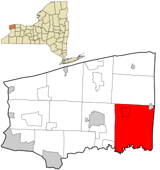
Royalton is a town in Niagara County, New York, United States. The population was 7,660 at the 2010 census.

Burke is a town in Caledonia County, Vermont, United States. The population was 1,651 at the 2020 census. The town contains the villages of East Burke, West Burke and Burke Hollow. The town is home to Burke Mountain and Burke Mountain Academy.

Lyndon is a town in Caledonia County, Vermont, United States. As of the 2020 census, the population was 5,491. Lyndon is the home of Lyndon State College. The town contains five unincorporated villages, Lyndonville just east of the geographic center of town, Lyndon Corner in the south, Lyndon Center in the center of town on the west side of Lyndonville, Little Egypt in the north, and East Lyndon in the southeast.

Lyndonville is a village in the town of Lyndon, in Caledonia County, Vermont, United States. Lyndonville's population was 1,136 at the 2020 census. It is the closest community to the Lyndon campus of Northern Vermont University.

Brighton is a town in Essex County, Vermont, United States. The population was 1,157 at the 2020 census. The town was named "Gilead" in its original grant in 1780. The town was sold to a group consisting primarily of soldiers commanded by Colonel Joseph Nightingale and subsequently named "Random". The town's name was finally changed by the legislature to "Brighton" in 1832. The Brighton village of Island Pond gets its name from the Abenaki word Menanbawk, which literally means island pond.

Island Pond is a census-designated place (CDP) in the town of Brighton in Essex County, Vermont, United States. The population was 750 at the 2020 census. It is part of the Berlin, NH–VT Micropolitan Statistical Area.

Eden is a town in Lamoille County, Vermont, United States. The population was 1,338 at the 2020 census.

Wolcott is a town in Lamoille County, Vermont, United States. The town was named for General Oliver Wolcott, a signer of the Declaration of Independence. The population was 1,670 at the 2020 census.

Brownington is a town in Orleans County, Vermont, United States. The population was 1,042 as of the 2020 census.

Coventry is a town in Orleans County, Vermont, United States. The population was 1,100 at the 2020 census.
Orleans is a village in the northwestern corner of Barton, Orleans County, Vermont, United States. With a population of 788 at the 2020 census, it is the largest village in the county.
Morristown is a hamlet and former village along the Saint Lawrence River in St. Lawrence County, New York, United States. The population was 395 at the 2010 census. The village is named after Gouverneur Morris.

Albany is a town in Orleans County, Vermont, United States. The population was 976 at the 2020 census. Albany contains four villages: the incorporated village of Albany, and the unincorporated villages of Albany Center, East Albany and South Albany.

Barton is a village located near the center of the town of Barton, in Orleans County, Vermont, United States. The population was 690 at the 2020 census.

Barton is a town in Orleans County, Vermont, United States. The population was 2,872 at the 2020 census. The town includes two incorporated villages, Barton and Orleans. Approximately a quarter of the town's population lives in each of the villages, and approximately half lives outside the villages. Only four other towns in the state contain two incorporated villages.

Newport is a town in Orleans County, Vermont, United States. The population was 1,526 at the 2020 census. The town is referred to by the United States Postal Service and the media as Newport Center, the name of the main settlement of the town. Newport is also the name of neighboring Newport City.
Newport is the only city in, and the shire town of, Orleans County, Vermont, United States. As of the 2020 Census, the population was 4,455. The city contains the second-largest population of any municipality in the county, and has the smallest geographic area. It is the second-smallest city by population in Vermont. Newport is also the name of neighboring Newport Town.


