Derby Line, Vermont

Last updated

Derby Line
Village
HaskellLibraryFront.jpg
Haskell Free Library and Opera House
USA Vermont location map.svg
Red pog.svg
Derby Line
Usa edcp location map.svg
Red pog.svg
Derby Line
Coordinates: 45°00′17.98″N72°05′57.97″W / 45.0049944°N 72.0994361°W / 45.0049944; -72.0994361
Country Flag of the United States (23px).png  United States
State Flag of Vermont.svg  Vermont
County Orleans County
Town Derby
OrganizedJune 16, 1977
Area
[1]
  Total0.73 sq mi (1.89 km2)
  Land0.73 sq mi (1.88 km2)
  Water0.00 sq mi (0.01 km2)
Elevation
1,056 ft (322 m)
Population
 (2020)
  Total687
  Density940/sq mi (360/km2)
Time zone UTC-5 (EST)
  Summer (DST) UTC-4 (EDT)
ZIP code
05830
Area code 802
FIPS code 50-17500 [2]
GNIS feature ID1457154 [3]

Derby Line is an incorporated village in the town of Derby in Orleans County, Vermont, United States, slightly north of the 45th parallel, the nominal U.S.-Canada boundary. The population was 687 at the 2020 census. [4]

Contents

The village is located on the Canada–United States border and is contiguous with the district of Rock Island in the town of Stanstead, Quebec. [5]

The US Canada border Border Patrol at Canadian border in Beebe Plain, Vermont.jpg
The US Canada border

Notable buildings include the Haskell Free Library and Opera House.

History

The village was incorporated in 1791. [6] It lies on an elevation at the far north of Derby, which was chartered on October 29, 1779, and first settled in 1795. By 1859, the area was noted for the beauty of its farmhouses and luxuriant farmland, set before the distant vista of Lake Memphremagog and the Green Mountains. [7]

Because of an erratic survey, the border separating Canada from the United States was drawn incorrectly by the surveyors in the 18th century, above the 45th parallel which was the agreed boundary. Derby Line was founded based on that line, above the 45th parallel. The boundary was confirmed by the Webster–Ashburton Treaty in 1842.

Description

Derby Line is known for the Haskell Free Library and Opera House, a line house deliberately constructed on the international border and opened in 1904. The donors were a binational couple: Carlos F. Haskell was a local American businessman who owned a number of sawmills, while Martha Stewart Haskell was Canadian. The intent was that people on both sides of the border would have use of the facility, which is now a designated historic site. Patrons of the library from either side of the border may use the facility without going through border security. [8]

Besides the library, five inhabited structures are divided by the border. Most residents use the US entrances to avoid problems with the border patrol; crossing the border within buildings does not require official permission. [9] A tool-and-die factory, once operated by the Butterfield division of Litton Industries, is also divided. [10] The factory in Canada closed in 1982 after a lengthy strike by Canadian workers. [11] The factory in Derby Line is open. It was bought in 1988 by Group Tivoly, a cutting tools company based in France, [12] and has 160 employees. [9]

There are ramifications to living directly on the border of another country. For example, the US Border Patrol expressed a desire to close off streets (such as Canusa Street) which have historically run together with those of Stanstead Town. [In many US locales the term for such a political entity is "township".] Border officials were concerned about illegal immigration. In 2007, the village of Derby Line met with the Mayor and Council of Stanstead in joint session in Québec, to be addressed by the authorities. Ironically, this meant that the Vermont village's trustee meeting was held in a foreign country, following Vermont procedural rules. [13] [14]

A telephone call between Derby Line, Vermont, and Rock Island, Québec, is local. [15]

Geography

According to the United States Census Bureau, the village has a total area of 0.7 square miles (1.8 km2), all land.

Climate

Climate data for Derby Line, Vermont
MonthJanFebMarAprMayJunJulAugSepOctNovDecYear
Record high °F (°C)64
(18)
62
(17)
83
(28)
87
(31)
92
(33)
95
(35)
98
(37)
95
(35)
96
(36)
84
(29)
74
(23)
66
(19)
98
(37)
Mean daily maximum °F (°C)26
(−3)
31
(−1)
41
(5)
54
(12)
69
(21)
77
(25)
81
(27)
79
(26)
70
(21)
57
(14)
43
(6)
31
(−1)
55
(13)
Mean daily minimum °F (°C)6
(−14)
8
(−13)
19
(−7)
31
(−1)
43
(6)
52
(11)
57
(14)
55
(13)
47
(8)
37
(3)
27
(−3)
13
(−11)
33
(1)
Record low °F (°C)−38
(−39)
−38
(−39)
−32
(−36)
−2
(−19)
20
(−7)
28
(−2)
36
(2)
32
(0)
23
(−5)
0
(−18)
−7
(−22)
−40
(−40)
−40
(−40)
Average precipitation inches (mm)2.96
(75)
2.16
(55)
2.96
(75)
2.93
(74)
3.67
(93)
3.93
(100)
4.19
(106)
4.18
(106)
3.76
(96)
3.45
(88)
3.47
(88)
3.12
(79)
40.78
(1,035)
Average snowfall inches (cm)24.7
(63)
17.2
(44)
18.8
(48)
6.9
(18)
0.2
(0.51)
0
(0)
0
(0)
0
(0)
0.1
(0.25)
1.1
(2.8)
11
(28)
23.1
(59)
103.1
(263.56)
Source: [16]

Demographics

Historical population
CensusPop.Note
1900 309
1910 39026.2%
1920 64064.1%
1930 6836.7%
1940 661−3.2%
1950 76716.0%
1960 84910.7%
1970 834−1.8%
1980 8744.8%
1990 855−2.2%
2000 776−9.2%
2010 673−13.3%
2020 6872.1%
U.S. Decennial Census [17]

As of the census [2] of 2000, there were 776 people, 329 households, and 225 families residing in the village. The population density was 1,057.5/sq mi (408.3/km2). There were 364 housing units at an average density of 496.0 per square mile (192.5/km2). The racial makeup of the village was 96.78% White, 0.39% African American, 0.90% Native American, 0.64% Asian, and 1.29% from two or more races. Hispanic or Latino of any race were 0.13% of the population.

There were 329 households, out of which 31.6% had children under the age of 18 living with them, 52.6% were married couples living together, 11.6% had a female householder with no husband present, and 31.6% were non-families. 27.1% of all households were made up of individuals, and 11.9% had someone living alone who was 65 years of age or older. The average household size was 2.36 and the average family size was 2.80.

In the village, the population was spread out, with 24.7% under the age of 18, 7.0% from 18 to 24, 25.6% from 25 to 44, 26.5% from 45 to 64, and 16.1% who were 65 years of age or older. The median age was 39 years. For every 100 females, there were 92.1 males. For every 100 females age 18 and over, there were 86.0 males.

Economy

Personal income

The median income for a household in the village was $33,966, and the median income for a family was $37,375. Males had a median income of $30,208 versus $21,667 for females. The per capita income for the village was $15,202. About 11.4% of families and 12.8% of the population were below the poverty line, including 17.8% of those under age 18 and 11.9% of those age 65 or over.

Industry

A local subsidiary of an international tool manufacturer employs 180 workers from the area. [18]

Infrastructure

Roads

The village is the northern terminus of both Interstate 91 and US 5, which both continue northward into Québec as Quebec Autoroute 55 and Quebec Route 143 respectively. [19]

Water

Drinking water for the adjacent towns of Derby Line and Stanstead is pumped from wells in Canada, stored in a reservoir in the United States and distributed through a system maintained by Canadians. Derby Line's sewage makes a cross-border trip for treatment. [5]

Derby Line shares emergency crews with Stanstead. Each responds to calls on both sides of the border.

Related Research Articles

<span class="mw-page-title-main">Orleans County, Vermont</span> County in Vermont, United States

Orleans County is a county located in the northeastern part of the U.S. state of Vermont. As of the 2020 census, the population was 27,393. Its shire town is the city of Newport. The county was created in 1792 and organized in 1799. As in the rest of New England, few governmental powers have been granted to the county. The county is an expedient way of grouping and distributing state-controlled governmental services.

<span class="mw-page-title-main">Franklin County, Vermont</span> County in Vermont, United States

Franklin County is a county located in the U.S. state of Vermont. As of the 2020 census, the population was 49,946. Its county seat is the city of St. Albans. It borders the Canadian province of Quebec. The county was created in 1792 and organized in 1796. Franklin County is part of the Burlington metropolitan area.

<span class="mw-page-title-main">Pittsburg, New Hampshire</span> Town in New Hampshire, United States

Pittsburg is a town in Coös County, New Hampshire, United States. The population was 800 at the 2020 census. It is the northernmost town in New Hampshire and the largest town by area in New England. U.S. Route 3 is the only major highway in the town, although the northern terminus of New Hampshire Route 145 also lies within Pittsburg.

<span class="mw-page-title-main">Lyndonville, Vermont</span> Village in Vermont, United States

Lyndonville is a village in the town of Lyndon, in Caledonia County, Vermont, United States. Lyndonville's population was 1,136 at the 2020 census. It is the closest community to the Lyndon campus of Northern Vermont University.

<span class="mw-page-title-main">Brighton, Vermont</span> Town in Vermont, United States

Brighton is a town in Essex County, Vermont, United States. The population was 1,157 at the 2020 census. The town was named "Gilead" in its original grant in 1780. The town was sold to a group consisting primarily of soldiers commanded by Colonel Joseph Nightingale and subsequently named "Random". The town's name was finally changed by the legislature to "Brighton" in 1832. The Brighton village of Island Pond gets its name from the Abenaki word Menanbawk, which literally means island pond.

<span class="mw-page-title-main">Canaan, Vermont</span> Town in Vermont, United States

Canaan is a town in Essex County, Vermont, United States. The population was 896 at the 2020 census. Canaan contains the village of Beecher Falls, located at the confluence of the Connecticut River and Halls Stream. It is part of the Berlin, NH-VT Micropolitan Statistical Area.

<span class="mw-page-title-main">Norton, Vermont</span> Town in Vermont, United States

Norton is a town in Essex County, Vermont, United States. The population was 153 at the 2020 census. It is part of the Berlin, NH –VT Micropolitan Statistical Area. It is located on the Canada–US border, immediately south of Stanhope, Quebec.

<span class="mw-page-title-main">Highgate, Vermont</span> Town in Vermont, United States

Highgate is a town in Franklin County, Vermont, United States. The population was 3,472 at the 2020 census. The town is on the Canada–US border and is a border town with Philipsburg, Quebec.

<span class="mw-page-title-main">Richford, Vermont</span> Town in Vermont, United States

Richford is a town in Franklin County, Vermont, United States, located along the Canada–United States border. The population was 2,346 at the 2020 census.

<span class="mw-page-title-main">Derby, Vermont</span> Town in Vermont, United States

Derby is a town in Orleans County, Vermont, United States. The population was 4,579 at the 2020 census, making it the most populous community in Orleans County. The town contains four unincorporated villages: Beebe Plain, Clyde Pond, Lake Salem, and North Derby, and two incorporated villages: Derby Center and Derby Line.

<span class="mw-page-title-main">Stanstead, Quebec</span> Border town in southern Quebec

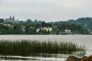
Stanstead is a town in the Memphrémagog Regional County Municipality in the Estrie region of Quebec, located on the Canada–United States border across from Derby Line, Vermont.

<span class="mw-page-title-main">Haskell Free Library and Opera House</span> Historic site in Quebec and Vermont

The Haskell Free Library and Opera House is a Victorian building that straddles the Canada–United States border, in Rock Island, Quebec, and Derby Line, Vermont, respectively. The Opera House opened on June 7, 1904, having deliberately been built on the international border. It was declared a heritage building by both countries in the 1970s and 1980s.

<span class="mw-page-title-main">Alburgh (town), Vermont</span> Town in Vermont, United States

Alburgh is a town in Grand Isle County, Vermont, United States, founded in 1781 by Ira Allen. The population was 2,106 at the 2020 United States Census. Alburgh is on the Alburgh Tongue, a peninsula extending from Canada into Lake Champlain, and lies on the only road-based route across Lake Champlain to New York state north of Addison, Vermont.

<span class="mw-page-title-main">Newport (city), Vermont</span> City in Vermont, United States

Newport is the only city in, and the shire town of, Orleans County, Vermont, United States. As of the 2020 Census, the population was 4,455. The city contains the second-largest population of any municipality in the county, and has the smallest geographic area. It is the second-smallest city by population in Vermont. Newport is also the name of neighboring Newport Town.

<span class="mw-page-title-main">Beebe Plain, Vermont</span> US portion of the internationally-divided, unincorporated village of Beebe Plain

Beebe Plain is an unincorporated community in the town of Derby in Orleans County, Vermont, United States, which extends into the municipality of Stanstead, Quebec, Canada. The village is divided by the Canada–United States border between Canada and the United States; the Canadian portion of Beebe Plain had the status of an incorporated municipality in its own right until 1995.

<span class="mw-page-title-main">Beebe Plain</span> Divided unincorporated village on Canada-USA border

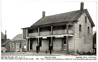
Beebe Plain is an unincorporated geographically-contiguous settlement, split politically between Canada and the United States. An unincorporated village partially in Stanstead and partially in Derby Line, it is divided by the Quebec-Vermont border. This settlement was begun by David and Calvin Beebe in 1798.

<span class="mw-page-title-main">Canusa Street</span> Street in Stanstead, Canada and Beebe Plain, Vermont, US

Canusa Street is a road part of Quebec Route 247.

<span class="mw-page-title-main">Derby Line–Stanstead Border Crossing</span> Border crossing between Canada and the United States

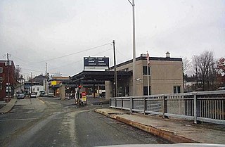
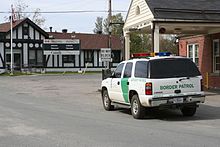
The Derby Line–Stanstead Border Crossing is a border crossing station on the Canada–United States border, connecting the towns of Stanstead, Quebec and Derby Line, Vermont. It connects Main Street in Derby Line with Quebec Route 143 in Stanstead. It is one of two local crossings between the two towns, which historically had many more. This was a major crossing point until the construction of Interstate 91 (I-91) and the Derby Line–Rock Island Border Crossing in 1965. The historic 1930s United States station facilities were listed on the National Register of Historic Places in 2014. Both stations are open 24 hours per day.

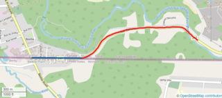
The Massawippi Valley Railway was a short line railway established in 1870 between Lennoxville, Quebec, and the Vermont border. Part of the Quebec Central Railway from 1926, the line was abandoned in 1990 and removed in 1992. Most of the former railway's right of way is now used for bicycle trails.

<span class="mw-page-title-main">Line house</span> Building deliberately built across a geopolitical boundary

A line house is a building deliberately located so that an international boundary passes through it. One such building on the boundary between the United States and Canada is the Haskell Free Library and Opera House in Stanstead, Quebec, and Derby Line, Vermont. The border is marked on the floor in a reading room and an auditorium. A number of single-family residences and some industrial buildings straddle the boundary in those two towns.

References

  1. "2019 U.S. Gazetteer Files". United States Census Bureau. Retrieved August 7, 2020.
  2. 1 2 "U.S. Census website". United States Census Bureau . Retrieved January 31, 2008.
  3. "U.S. Board on Geographic Names". United States Geological Survey. October 25, 2007. Retrieved January 31, 2008.
  4. "Census - Geography Profile: Derby Line village, Vermont". United States Census Bureau . Retrieved December 26, 2021.
  5. 1 2 Austen, Ian (July 18, 2007). "Quebec and Vermont Towns Bond Over a Sleepy Border". The New York Times . Archived from the original on October 4, 2011. Retrieved April 2, 2021.{{cite news}}: CS1 maint: unfit URL (link)
  6. Holland Historical Society (2004). Holland and Its Neighbors. Arcadia Publishing. p. 39. ISBN   0-7385-3614-8.
  7. Austin J. Coolidge & John B. Mansfield, A History and Description of New England; Boston, Massachusetts 1859
  8. Ring, William (May 25, 2007). "Border crackdown could hit binational library". Burlington Free Press.
  9. 1 2 "Chapter 3: The 45th Parallel". United Divide: A Linear Portrait of the USA/Canada Border. The Center for Land Use Interpretation. Winter 2015.
  10. "History of Butterfield's". The Stanstead Journal. July 31, 1952.
  11. "Butterfield's: Important Invention Leads to International Factory | Townships Heritage WebMagazine". Townshipsheritage.com. Retrieved August 16, 2016.
  12. "Cutting tools". Tivoly INC. Archived from the original on January 12, 2012. Retrieved January 25, 2012.
  13. Greeser, Joseph (May 23, 2007). "Border meeting set for Thursday". The Chronicle.
  14. "A border runs through it: Tiny town worries feds". CNN.com (AP). May 26, 2007. Archived from the original on June 18, 2007.
  15. "Local call finder". Local calling guide. July 31, 2016. Retrieved August 16, 2016.
  16. "Intellicast - Derby Line Historic Weather Averages in Vermont (05830)". www.intellicast.com.
  17. "Census of Population and Housing". Census.gov. Retrieved June 4, 2015.
  18. "Tivoly Inc (Tivoly, Inc) - Derby Line, Vermont (VT) | Company Profile". Manta.com. Retrieved January 25, 2012.
  19. Vermont Atlas & Gazetteer. DeLorme. 2007. p. 54. ISBN   978-0899333229.

45°0′17.98″N72°5′57.97″W / 45.0049944°N 72.0994361°W / 45.0049944; -72.0994361