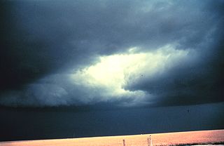
A severe thunderstorm warning is a type of public warning for severe weather that is issued by weather forecasting agencies worldwide when one or more severe thunderstorms have been detected by Doppler weather radar, observed by weather spotters, or reported by an emergency management agency, law enforcement, or the general public. Unlike a watch, a warning is issued to areas in the direct path of active severe thunderstorms, that are expecting a direct impact typically within an hour. Severe thunderstorms can cause property damage and injury due to large hail, high winds, and flooding due to torrential rainfall. The exact criteria to issue a warning varies from country to country.
A winter storm warning is a hazardous weather statement issued by Weather Forecast Offices (WFO) of the National Weather Service (NWS) in the United States to alert the public that a winter storm is occurring or is about to occur in the area, usually within 36 hours of the storm's onset.

A gale warning is an alert issued by national weather forecasting agencies around the world in an event that maritime locations currently or imminently experiencing winds of gale force on the Beaufort scale. Gale warnings allow mariners to take precautionary actions to ensure their safety at sea or to seek safe anchorage and ride out the storm on land. Though usually associated with deep low-pressure areas, winds strong enough to catalyze a gale warning can occur in other conditions too, including from anticyclones, or high-pressure systems, in the continental interior. The winds are not directly associated with a tropical cyclone.
A winter weather advisory is a hazardous weather statement issued by Weather Forecast Offices (WFO) of the National Weather Service in the United States when one or more types of winter precipitation—snow, rain and snow mixed, freezing rain, sleet, graupel, etc.—presenting a hazard, but not expected to produce accumulations meeting storm warning criteria, are forecast within 36 hours of the expected onset of precipitation or are occurring in the advisory's coverage area.
A blowing snow advisory was issued by the National Weather Service of the United States when wind driven snow reduces surface visibility and possibly hampers traveling. Blowing snow may be falling snow, or snow that has already accumulated but is picked up and blown by strong winds. This advisory was discontinued beginning with the 2008–09 winter storm season, replaced by the winter weather advisory for snow and blowing snow. However, if the storm is judged to be dangerous by local forecasters, a winter storm warning for heavy snow and blowing snow may be issued.
A winter storm watch is issued by the National Weather Service of the United States when there is a possibility of heavy snow or potential of significant ice accumulations, without meeting a specific other winter criteria. The watch is typically issued 12 to 48 hours before the storm's expected arrival in the given area. The criteria for this watch can vary from place to place, which is true with other winter weather warning and advisories.
A lake effect snow advisory was issued by the National Weather Service of the United States when lake effect snow may pose a hazard or is life-threatening. The snow must be completely caused by a convective snow development over a lake and not by a low pressure system. The criteria for this advisory vary from area to area.
A heavy snow warning was a hazardous weather statement issued by the Weather Forecast Offices of the National Weather Service (NWS) in the United States which indicates a high rate of snowfall was occurring or was forecast to occur. Generally, the warning was issued for snowfall rates of 6 inches (15 cm) or more in 12 hours, or 8 inches (20 cm) or more in 24 hours.

At sea, a storm warning is a warning issued by the National Weather Service of the United States when winds between 48 knots and 63 knots are occurring or predicted to occur soon. The winds must not be associated with a tropical cyclone. If the winds are associated with a tropical cyclone, a tropical storm warning will be substituted for the storm warning and less severe gale warning.

This article describes severe weather terminology used by the National Weather Service (NWS) in the United States. The NWS, a government agency operating as an arm of the National Oceanic and Atmospheric Administration (NOAA) branch of the United States Department of Commerce (DoC), defines precise meanings for nearly all of its weather terms.
A snow squall warning is a bulletin issued by Environment Canada's Meteorological Service of Canada and the National Weather Service in the United States to warn population of two types of snow events reducing visibility in blowing snow: lake effectsnow squalls and frontal snow squalls.

This article describes severe weather terminology used by the Meteorological Service of Canada, a branch within Environment and Climate Change Canada. The article primarily describes various weather warnings, and their criteria. Related weather scales and general weather terms are also addressed in this article. Some terms are specific to certain regions.
In weather forecasting in the United States, "particularly dangerous situation" (PDS) is enhanced wording used by the National Weather Service to convey special urgency in some watch or warning messages when there is a significant risk of extreme weather, most commonly from types of weather events that are usually less severe by comparison, such as a severe thunderstorm outbreak or flash flooding. It is used in the format "This is a particularly dangerous situation..." at the discretion of the issuing forecaster. A watch or warning bearing the phrase is referred to as a PDS watch or PDS warning as shorthand jargon.
A tornado emergency is an enhanced version of a tornado warning, which is used by the National Weather Service (NWS) in the United States during imminent, significant tornado occurrences in highly populated areas. Although it is not a new warning type from the NWS, issued instead within a severe weather statement or in the initial tornado warning, a tornado emergency generally means that significant, widespread damage is expected to occur and a high likelihood of numerous fatalities is expected with a large, strong to violent tornado.

A blizzard warning is a hazardous weather statement issued by Weather Forecast Offices (WFO) of the National Weather Service (NWS) in the United States, which indicates heavy snowfall accompanied by sustained winds or frequent gusts of 35 mph (56 km/h) or greater are forecast to occur for a minimum of three hours. A blizzard tends to reduce visibilities to 1⁄4 mile (400 m) or less.
A blizzard watch was a bulletin issued by the National Weather Service of the United States which meant winds greater than 35 miles per hour, mixed with falling or blowing snow, and visibilities of 1⁄4 mile (0.4 km) or less is forecast for a period of 3 hours or more. A blizzard watch was issued 12 to 48 hours before an expected blizzard event. As the forecast solidifies, a blizzard watch would be either downgraded to a winter storm warning or winter weather advisory for blowing snow or upgraded to a blizzard warning.

An extreme wind warning is an alert issued by the National Weather Service for areas that will experience sustained surface winds 100 knots or greater within one hour, due to a landfalling tropical cyclone. Extreme wind warnings are intended to provide guidance to the general public at a county or sub-county level when such winds pose a significant threat of casualties. Their issuance is intended to cover as precise of an area as possible and can be issued no earlier than two hours before the onset of extreme winds. The extreme wind warning should not be confused with tornado warnings, which covers rotating supercells from severe storms, and high wind warnings, which is similar, but used for non-severe/tornadic winds of 40 mph to 114 mph, mainly on land.
A wind chill warning is a hazardous weather statement issued by local forecast offices of the National Weather Service (NWS) in the United States and previously by the Meteorological Service of Environment and Climate Change Canada (ECCC) when wind chills are forecast to reach values low enough for residents and travelers to be susceptible to life-threatening medical conditions or death associated with accelerated body heat loss.

During the afternoon of April 27, 2011, a violent EF5 tornado touched down in eastern Mississippi, killing three people. Part of the historic 2011 Super Outbreak, the largest tornado outbreak on record, this was the first of four EF5 tornadoes to touch down that day and the first such storm in Mississippi since the 1966 Candlestick Park tornado. While on the ground for 30 minutes, it traveled along a 28.28-mile (45.51 km) path through four counties, leaving behind three deaths, eight injuries, and $1.1 million in damage.

This page documents notable tornadoes and tornado outbreaks worldwide in 2020. Strong and destructive tornadoes form most frequently in the United States, Argentina, Brazil, Bangladesh, and eastern India, but can occur almost anywhere under the right conditions. Tornadoes also develop occasionally in southern Canada during the Northern Hemisphere's summer and somewhat regularly at other times of the year across Europe, Asia, Argentina, Australia and New Zealand. Tornadic events are often accompanied by other forms of severe weather, including strong thunderstorms, strong winds, and hail.


