Related Research Articles

A small craft advisory is a type of wind warning issued by the National Weather Service in the United States. In Canada a similar warning is issued by Environment Canada. It is issued when winds have reached, or are expected to reach within 12 hours, a speed marginally less than gale force. A Small Craft Advisory may also be issued when sea or lake ice exists that could be hazardous to small boats.

Hurricane Donna, known in Puerto Rico as Hurricane San Lorenzo, was the strongest hurricane of the 1960 Atlantic hurricane season, and caused severe damage to the Lesser Antilles, the Greater Antilles, and the East Coast of the United States, especially Florida, in August–September. The fifth tropical cyclone, third hurricane, and first major hurricane of the season, Donna developed south of Cape Verde on August 29, spawned by a tropical wave to which 63 deaths from a plane crash in Senegal were attributed. The depression strengthened into Tropical Storm Donna by the following day. Donna moved west-northwestward at roughly 20 mph (32 km/h) and by September 1, it reached hurricane status. Over the next three days, Donna deepened significantly and reached maximum sustained winds of 130 mph (210 km/h) on September 4. Thereafter, it maintained intensity as it struck the Lesser Antilles later that day. On Sint Maarten, the storm left a quarter of the island's population homeless and killed seven people. An additional five deaths were reported in Anguilla, and there were seven other fatalities throughout the Virgin Islands. In Puerto Rico, severe flash flooding led to 107 fatalities, 85 of them in Humacao alone.
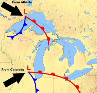
The Great Lakes Storm of 1913 was a blizzard with hurricane-force winds that devastated the Great Lakes Basin in the Midwestern United States and Southwestern Ontario, Canada, from November 7 to 10, 1913. The storm was most powerful on November 9, battering and overturning ships on four of the five Great Lakes, particularly Lake Huron.
A winter storm warning is a hazardous weather statement issued by Weather Forecast Offices (WFO) of the National Weather Service (NWS) in the United States to alert the public that a winter storm is occurring or is about to occur in the area, usually within 36 hours of the storm's onset.

A gale warning is an alert issued by national weather forecasting agencies around the world in an event that maritime locations currently or imminently experiencing winds of gale force on the Beaufort scale. Gale warnings allow mariners to take precautionary actions to ensure their safety at sea or to seek safe anchorage and ride out the storm on land. Though usually associated with deep low-pressure areas, winds strong enough to catalyze a gale warning can occur in other conditions too, including from anticyclones, or high-pressure systems, in the continental interior. The winds are not directly associated with a tropical cyclone.
A winter weather advisory is a hazardous weather statement issued by Weather Forecast Offices (WFO) of the National Weather Service in the United States when one or more types of winter precipitation—snow, rain and snow mixed, freezing rain, sleet, graupel, etc.—presenting a hazard, but not expected to produce accumulations meeting storm warning criteria, are forecast within 36 hours of the expected onset of precipitation or are occurring in the advisory's coverage area.
A blowing snow advisory was issued by the National Weather Service of the United States when wind driven snow reduces surface visibility and possibly hampers traveling. Blowing snow may be falling snow, or snow that has already accumulated but is picked up and blown by strong winds. This advisory was discontinued beginning with the 2008–09 winter storm season, replaced by the winter weather advisory for snow and blowing snow. However, if the storm is judged to be dangerous by local forecasters, a winter storm warning for heavy snow and blowing snow may be issued.

At sea, a storm warning is a warning issued by the National Weather Service of the United States when winds between 48 knots and 63 knots are occurring or predicted to occur soon. The winds must not be associated with a tropical cyclone. If the winds are associated with a tropical cyclone, a tropical storm warning will be substituted for the storm warning and less severe gale warning.

This article describes severe weather terminology used by the National Weather Service (NWS) in the United States. The NWS, a government agency operating as an arm of the National Oceanic and Atmospheric Administration (NOAA) branch of the United States Department of Commerce (DoC), defines precise meanings for nearly all of its weather terms.

Hurricane Esther was the first large tropical cyclone to be discovered by satellite imagery. The fifth tropical cyclone, named storm, and hurricane of the 1961 Atlantic hurricane season, Esther developed from an area of disturbed weather hundreds of miles west-southwest of the southernmost Cape Verde Islands on September 10. Moving northwestward, the depression strengthened into Tropical Storm Esther on September 11, before reaching hurricane intensity on the following day. Early on September 13, Esther curved westward and deepened into a major hurricane. The storm remained a Category 3 hurricane for about four days and gradually moved in a west-northwestward direction. Late on September 17, Esther strengthened into a Category 5 hurricane with sustained winds of 160 mph (260 km/h) on September 18. The storm curved north-northeastward on September 19, while offshore of North Carolina. Esther began to weaken while approaching New England and fell to Category 3 intensity on September 21. The storm turned eastward early on the following day, and rapidly weakened to a tropical storm.
In weather forecasting in the United States, "particularly dangerous situation" (PDS) is enhanced wording used by the National Weather Service to convey special urgency in some watch or warning messages when there is a significant risk of extreme weather, most commonly from types of weather events that are usually less severe by comparison, such as a severe thunderstorm outbreak or flash flooding. It is used in the format "This is a particularly dangerous situation..." at the discretion of the issuing forecaster. A watch or warning bearing the phrase is referred to as a PDS watch or PDS warning as shorthand jargon.

A blizzard warning is a hazardous weather statement issued by Weather Forecast Offices (WFO) of the National Weather Service (NWS) in the United States, which indicates heavy snowfall accompanied by sustained winds or frequent gusts of 35 mph (56 km/h) or greater are forecast to occur for a minimum of three hours. A blizzard tends to reduce visibilities to 1⁄4 mile (400 m) or less.
A lake wind advisory is issued by the United States National Weather Service local forecast offices when windy conditions on area lakes are expected to be hazardous for boaters and other recreational events on or around lakes.
A wind chill advisory is a hazardous weather statement issued by Weather Forecast Offices (WFO) of the National Weather Service (NWS) in the United States to alert the public that wind chills are forecast to reach values low enough that it poses a threat to human health and life if adequate protection is not taken against hypothermia and frostbite. The exact criteria meriting the issuance of an advisory varies from state to state, and areas prone to colder temperatures will often require the wind chill to be lower before issuing an advisory.
A gale watch is issued by the National Weather Service of the United States when there is an increased risk for a gale-force wind event, meaning sustained surface winds, or frequent gusts, of 34 to 47 knots, but the occurrence, location, and/or timing of the event is still uncertain.
A Hazardous Seas Watch is issued by the National Weather Service of the United States when there is an increased threat of high wave heights and/or wave steepness values reach a certain criteria, but the occurrence, timing, and/or location are still uncertain, though the area of concern is known. The criteria are set by the local forecast offices. It is normally accompanied with strong winds, and occasionally even cyclonic activity. Such tall waves can pose a serious threat to vessels that do not seek shelter, as well as vehicles and property very close to concerned waters.
A Heavy Freezing Spray Warning is issued by the National Weather Service of the United States to warn vessels that rapid accumulation and icing of freezing water droplets due to a combination of cold water, wind, cold air, and vessel or vehicle movement is likely. Accumulation rates of 2 cm per hour or greater must be possible for a warning to be issued, or else a freezing spray advisory would be issued.
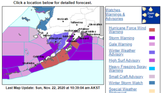
A hurricane force wind warning is a warning issued by the National Weather Service of the United States when sustained winds or frequent gusts of 64 knots or greater are either being observed or are predicted to occur. The winds must not be directly associated with a tropical cyclone, or a hurricane warning will be issued. If winds are lighter than 64 knots, a storm warning or gale warning will be issued. The hurricane force wind warning is only used to warn of the possibility of wind which reaches hurricane-level severity, but lacks direct connection with a hurricane system. The hurricane force wind can either signal sustained winds of 64 knots, or gusts of 64 knots lasting for two or more hours.
A wind advisory is generally issued by the National Weather Service of the United States when there are sustained thunderstorm winds of 31–39 miles per hour (50–63 km/h) and/or gusts of 46–57 miles per hour (74–92 km/h) over land. Winds over the said cap will trigger high wind alerts rather than a wind advisory. The advisory is site specific, but winds of this magnitude occurring over an area that frequently experiences such wind speeds on a basis will not trigger a wind advisory. A slightly lower wind speed in areas around lakes may trigger a Lake wind advisory instead.

The November 2011 Bering Sea cyclone was one of the most powerful extratropical cyclones to affect Alaska on record. On November 8, the National Weather Service (NWS) began issuing severe weather warnings, saying that this was a near-record storm in the Bering Sea. It rapidly deepened from 973 mb (28.7 inHg) to 948 mb (28.0 inHg) in just 24 hours before bottoming out at 943 mbar, roughly comparable to a Category 3 or 4 hurricane. The storm had been deemed life-threatening by many people. The storm had a forward speed of at least 60 mph (97 km/h) before it had reached Alaska. The storm began affecting Alaska in the late hours of November 8, 2011. The highest gust recorded was 93 mph (150 km/h) on Little Diomede Island. One person was reported missing after being swept into the Bering Sea, and he was later pronounced dead.
References
- ↑ National Weather Service. "Hazardous Seas Warning". Glossary - National Weather Service. Retrieved 20 May 2011.
- ↑ National Weather Service. "Hazardous Seas Warning". Iowa Environmental Mesonet NWS Product Archive. Retrieved 20 May 2011.