Related Research Articles
Lima Allen County Airport is six miles southeast of Lima, in Allen County, Ohio. It is owned by the Allen County Regional Airport Authority.
Pittsfield Municipal Airport is two miles west of Pittsfield, in Berkshire County, Massachusetts. The National Plan of Integrated Airport Systems for 2011–2015 categorized it as a general aviation facility.

Hutchinson Municipal Airport is a city-owned public airport three miles east of Hutchinson, in Reno County, Kansas, United States.

Riverside Municipal Airport, is four miles (6 km) southwest of downtown Riverside, the county seat of Riverside County, California, United States.

Zanesville Municipal Airport is a city-owned airport six miles east of downtown Zanesville, in Muskingum County, Ohio. The National Plan of Integrated Airport Systems for 2011–2015 called it a general aviation facility.

Apple Valley Airport is a public airport three miles (4.8 km) north of Apple Valley in San Bernardino County, California, United States. The airport has two runways and is used for general aviation. It opened around 1970.
London-Corbin Airport is in Laurel County, Kentucky, three miles south of London and about 12 miles north of Corbin. The airport is operated by both cities.

Southeast Colorado Regional Airport (formerly known as the Lamar Municipal Airport) (IATA: LAA, ICAO: KLAA, FAA LID: LAA) is in Prowers County, Colorado, three miles southwest of Lamar, which owns it. The National Plan of Integrated Airport Systems for 2011–2015 called it a general aviation facility.

Corvallis Municipal Airport is five miles southwest of Corvallis, in Benton County, Oregon. The National Plan of Integrated Airport Systems for 2011–2015 categorized it as a general aviation facility.

McMinnville Municipal Airport is three miles southeast of McMinnville, in Yamhill County, Oregon. The FAA's National Plan of Integrated Airport Systems for 2009–2013 categorized it as a general aviation facility. It is across Oregon Route 18 from the Evergreen Aviation & Space Museum, home to the Hughes H-4 Hercules Spruce Goose flying boat.
Delaware County Regional Airport is in Delaware County, Indiana three miles northwest of Muncie. Owned by the Delaware County Airport Authority, it was formerly Delaware County Airport and Johnson Field. The National Plan of Integrated Airport Systems for 2011–2015 categorized it as a general aviation facility.
Marfa Municipal Airport is three miles north of Marfa in Presidio County, Texas. There is currently no scheduled airline service to the airport; until 1960 Trans-Texas DC-3s stopped at the former Marfa AAF, now abandoned, at 30.256N 103.882W east of Marfa.

Northeast Alabama Regional Airport is five miles southwest of Gadsden, in Etowah County, Alabama. It is owned by Gadsden Airport Authority and it used to be Gadsden Municipal Airport. The FAA's National Plan of Integrated Airport Systems for 2009–2013 categorized as a general aviation facility.
Manitowoc County Airport is located two miles northwest of Manitowoc, in Manitowoc County, Wisconsin. It is 21 miles from Whistling Straights golf course and 34 minutes from Road America.

Moultrie Municipal Airport is seven miles south of Moultrie in Colquitt County, Georgia, United States. The National Plan of Integrated Airport Systems for 2011–2015 categorized it as a general aviation facility. It has no airline service.
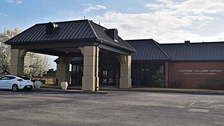
LaGrange Callaway Airport is a public airport three miles southwest of LaGrange, in Troup County, Georgia. The FAA's National Plan of Integrated Airport Systems for 2009-2013 called it a general aviation airport.

Kokomo Municipal Airport is five miles northeast of Kokomo, in Howard County, Indiana. It is owned by the Kokomo Board of Aviation Commissioners. The FAA's National Plan of Integrated Airport Systems for 2009–2013 categorized it as a general aviation facility.
Marion Municipal Airport is located three miles southwest of Marion, in Grant County, Indiana. The FAA's National Plan of Integrated Airport Systems for 2021–2025 categorized it as a general aviation facility.
Richmond Municipal Airport is six miles southeast of Richmond near Boston, in Wayne County, Indiana. It is owned by the Richmond Board of Aviation Commissioners. The National Plan of Integrated Airport Systems for 2011–2015 called it a general aviation facility.

Bartlesville Municipal Airport is in Osage County, Oklahoma, United States. It is owned by the City of Bartlesville and is one mile northwest of downtown. The National Plan of Integrated Airport Systems for 2011–2015 called it a general aviation facility.
References
- 1 2 "Dyersburg Municipal (DYR)". Airport Directory. Tennessee DOT . Retrieved 2008-08-08.
- 1 2 3 4 5 FAA Airport Form 5010 for DYR PDF , effective 2023-10-05.
- ↑ "KDYR - Dyersburg, Tennessee". Great Circle Mapper. Retrieved 2009-08-08.
- ↑ "DYR / UHMA - Anadyr Airport, Russia". Aviation Safety Network. Retrieved 2009-08-08.
- ↑ "(DYR) DYERSBURG RGNL AIRPORT DATA AND INFORMATION PORTAL". Federal Aviation Administration. Retrieved Jun 16, 2022.
- ↑ "NOTAMS for Dyersburg Regional Airport". Federal Aviation Administration (via ourairports.com). Retrieved Jun 16, 2022.
- ↑ Jones, M. (1999). Patsy: The Life and Times of Patsy Cline. Da Capo Press. p. 287. ISBN 9780306808869 . Retrieved 2014-10-11.