1963 Camden PA-24 crash

Last updated

1963 Camden PA-24 crash
G-ASEO Piper Comanche (24155579381).jpg
A Piper PA-24 Comanche, similar to the aircraft involved
Accident
DateMarch 5, 1963;61 years ago (1963-03-05)
Summary Pilot error leading to spatial disorientation and subsequent loss of control
Site Camden, Tennessee, United States
36°03′44″N88°09′38″W / 36.06222°N 88.16056°W / 36.06222; -88.16056
Aircraft
Aircraft type Piper PA-24-250 Comanche
Registration N7000P
Flight origin Kansas City, Kansas
Destination Nashville, Tennessee
Occupants4
Passengers3
Crew1
Fatalities4
Survivors0

On March 5, 1963, American country music performers Patsy Cline, Cowboy Copas, and Hawkshaw Hawkins were killed in an airplane crash near Camden, Tennessee, United States, along with pilot Randy Hughes. The accident occurred as the three artists were returning home to Nashville, Tennessee, after performing in Kansas City, Kansas.

Contents

Shortly after takeoff from a refueling stop, Hughes lost control of the small Piper PA-24 Comanche while flying in low-visibility conditions, and crashed into a wooded area, leaving no survivors. Investigators concluded that the crash was caused by the non-instrument-rated pilot's decision to operate under visual flight rules in instrument meteorological conditions.

Accident

Around 2 pm on Tuesday, March 5, 1963, the Piper Comanche, piloted by Randy Hughes, departed Fairfax Municipal Airport in Kansas City, Kansas. It was operating as an unscheduled cross-country passenger flight under visual flight rules (VFR) to its destination of Nashville, 411 nautical miles (761 km; 473 mi) to the southeast. Later that afternoon, the aircraft landed to refuel at Rogers Municipal Airport in Rogers, Arkansas, and departed 15 minutes later. [1]

Hughes later made contact with Dyersburg Regional Airport in Dyersburg, Tennessee, and landed there at 5:05 pm, where he requested a weather briefing for the remainder of the flight to Nashville. He was informed by Federal Aviation Administration (FAA) employee Leroy Neal that local conditions were marginal for VFR flight and weather at the destination airport was below VFR minima. Hughes then asked if the Dyersburg runways were lit at night in case he had to return and Neal replied that they were. Hughes then informed Neal he would fly east towards the Tennessee River and navigate to Nashville from there, as he was familiar with the terrain in that area. He expressed concern about a 2,049-foot (625 m) high television transmitting tower north of Nashville, then stated that he would attempt the flight and return if the weather conditions worsened. [1]

After refueling, the passengers and pilot reboarded the Piper Comanche. Hughes requested another weather briefing by radio, then taxied into position and took off at 6:07 pm. After takeoff, no further radio contact was made with N7000P. The reported weather at that time was a ceiling of 500 feet (150 m), visibility of 5 miles (8.0 km), temperature of 43 °F (6 °C), gusty and turbulent wind from the east at 20 miles per hour (17 kn), and cloudy. [2] A short time later, an aviation-qualified witness, about 4 miles (6.4 km) west of Camden, heard a low-flying aircraft on a northerly course. The engine noise increased and seconds later a white light appeared from the overcast, descending in a 45° angle. [1]

At 6:29 pm, the aircraft crashed into a wooded, swampy area 1 mile (1.6 km) north of U.S. Route 70 and 5 miles (8.0 km) west of Camden. The aircraft was destroyed on impact and all four occupants were killed. The witness described hearing a dull-sounding crash, followed by complete silence. [1]

Aircraft and crew

Registered as N7000P, [3] the aircraft was a three-year-old PA-24-250 Comanche four-seat, light, single-engined airplane manufactured in 1960 by Piper Aircraft. Serial Number 24-2144 was equipped with a Lycoming O-540-A1D5 250 hp (190 kW) normally aspirated engine, turning a constant-speed propeller. The Comanche's maximum takeoff weight was 2,800 lb (1,300 kg) with a total fuel load of 60 US gallons (230 L), giving a range of 600 nm at 75% power including a 45-minute reserve. [4] The aircraft had passed its last FAA inspection on April 19, 1962. [2]

The owner and pilot of the aircraft, Ramsey (Randy) Dorris Hughes, 34, was also Patsy Cline's manager and the son-in-law of Cowboy Copas. [5] Hughes held a valid private pilot certificate with an airplane single-engined land rating, but was not rated to fly under instrument flight rules. Hughes had taken possession of the airplane in 1962, less than a year before the crash, and was an inexperienced pilot with a total flight time of 160.2 hours, including 44:25 logged in the Piper Comanche. [2]

Aftermath and investigation

After the witness notified the Tennessee Highway Patrol, two law enforcement officers performed a preliminary search of the area around 7 pm, but they found nothing. By 11:30 pm, a search party was organized consisting of the Highway Patrol, Civil Defense, and local officers who searched the area throughout the night. At 6:10 am on March 6, the wreckage was discovered. A three-foot hole indicated the area of initial impact, and debris was scattered over an area 166 feet (51 m) long and 130 feet (40 m) wide. [1]

During the FAA investigation, the aircraft's propeller was found to have contacted a tree 30 feet (9.1 m) above the ground while the aircraft was in a 26° nose-down attitude. The right wing then collided with another tree 32 feet (9.8 m) to the right, causing the airplane to become inverted. The downward angle increased to 45° and the Comanche hit the ground at an estimated speed of 175 miles per hour (282 km/h), about 62 feet (19 m) from the initial contact. [1]

Inspection of the airframe and engine disclosed that the aircraft was intact and the engine was developing substantial power before impacting the trees. Investigators found no evidence of engine or system failure or malfunction of the aircraft prior to the crash. The airplane was determined to be slightly over maximum gross weight when it departed Dyersburg airport, but this fact had no bearing on the crash. An autopsy of the pilot discovered no physical or medical concerns that could have been a factor in the accident. [6]

Investigators believe that Hughes entered an area of deteriorating weather with low visibility and lost his visual reference with the ground. This induced spatial disorientation, and eventually led to a graveyard spiral with the aircraft entering into a right-hand diving turn, with a nose-down attitude of 25°. When the aircraft cleared the clouds, Hughes attempted to arrest the high descent rate by pulling the nose up and applying full power, but it was too late. The FAA investigators later found evidence that the propeller was at maximum speed during impact. [1]

The FAA's final conclusion was the non-instrument-rated pilot attempted visual flight in adverse weather conditions, resulting in disorientation and subsequent loss of control. [6]

See also

Related Research Articles

<span class="mw-page-title-main">Akron–Canton Airport</span> Airport in Green, Ohio, United States

Akron–Canton Airport is a commercial airport in the city of Green, in southern Summit County, Ohio. The airport is located about 14 miles (23 km) southeast of Akron and 10 miles (16 km) northwest of Canton. It is jointly operated by Summit County and Stark County. The airport is a "reliever" airport for Northeast Ohio and markets itself as "A better way to go", emphasizing the ease of travel in comparison to Cleveland Hopkins International Airport. Just under 90% of its traffic is general aviation. It is included in the Federal Aviation Administration (FAA) National Plan of Integrated Airport Systems for 2019–2023, in which it is categorized as a small-hub primary commercial service facility.

<span class="mw-page-title-main">Brown Field Municipal Airport</span> Airport

Brown Field Municipal Airport is in the Otay Mesa neighborhood of San Diego, California, United States, 13 miles (21 km) southeast of Downtown San Diego and named in honor of Commander Melville S. Brown, USN, who was killed in an airplane crash in 1936. Its main runway is 7,972 feet (2,430 m) long. Its FAA/IATA airport code is SDM. Formerly Naval Auxiliary Air Station Brown Field, it is now a civilian reliever airport and a port of entry from Mexico. It is sometimes staffed by the U.S. Customs Service, but only upon request of incoming pilots to the Federal Aviation Administration. The development plans for the SDM airport have been announced on 4th Oct 2022, the development will occur in phases over 20 years. The plans include a new FBO terminal building and individual airplane hangars. There is also talk of adding a million square feet of retail and industrial buildings and possibly a hotel.

<span class="mw-page-title-main">North Las Vegas Airport</span> Airport in Nevada, U.S.

North Las Vegas Airport is a public-use airport 3 mi (4.8 km) northwest of downtown Las Vegas in North Las Vegas, Nevada. It is owned by the Clark County Commission and operated by the Clark County Department of Aviation.

<span class="mw-page-title-main">John C. Tune Airport</span> Airport

John C. Tune Airport is a public airport located in the western portion of the city of Nashville in Davidson County, Tennessee, United States. It is owned by the Metropolitan Nashville Airport Authority, located approximately one mile off of Briley Parkway in the Cockrill Bend area. It is a Class D airport.

<span class="mw-page-title-main">Mansfield Lahm Regional Airport</span> Airport in Mansfield, Ohio

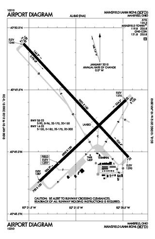
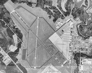
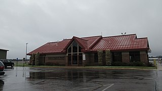
Mansfield Lahm Regional Airport is three miles (5 km) north of Mansfield, in Richland County, Ohio. By car the airport is an hour away from Cleveland and Columbus, near Interstate I-71, US Rt 30, State Route 13.

<span class="mw-page-title-main">Smyrna Airport (Tennessee)</span> Airport in Smyrna, TN, US

Smyrna Airport is a public general aviation and military use airport located two nautical miles (4 km) north of the central business district of Smyrna, a town in Rutherford County, Tennessee, United States. It is owned by the Smyrna / Rutherford County Airport Authority. Smyrna Airport is the third largest airport in Tennessee and is the state's busiest general aviation airport. Prior to March 1971, the facility was an active military installation known as Sewart Air Force Base.

Cheboygan County Airport is a public use airport located two nautical miles (3.7 km) west of the central business district of Cheboygan, a city in Cheboygan County, Michigan, United States. It is owned by the Cheboygan Airport Authority. It is included in the Federal Aviation Administration (FAA) National Plan of Integrated Airport Systems for 2017–2021, in which it is categorized as a basic general aviation facility. The airport is accessible from Levering Road and is close to US Highway 23.

<span class="mw-page-title-main">Gaylord Regional Airport</span> Airport

Gaylord Regional Airport is a county-owned, public-use airport located one nautical mile (2 km) southwest of the central business district of Gaylord, a city in Otsego County, Michigan, United States. It is included in the Federal Aviation Administration (FAA) National Plan of Integrated Airport Systems for 2017–2021, in which it is categorized as a local general aviation facility.

Fairfield County Airport is a public use airport in Fairfield County, Ohio, United States. It is located three nautical miles (6 km) northwest of the central business district of Lancaster, the county seat. The airport is owned by the Fairfield County Commissioners.

Griffing Sandusky Airport was a public airport in Erie County, Ohio, next to Sandusky Bay three miles southeast of Sandusky. The airport permanently closed on December 31, 2013 and the FAA A/FD and VFR sectional charts no longer show the airport as open or operational. Instrument approach procedures are no longer available from the FAA's website. All hangars and the entrance were demolished in April, 2016. The Sandusky Register confirmed that the city announced that a sports park will replace the airport and now has opened in spring 2017 called the Cedar Point Sports Center.

<span class="mw-page-title-main">Joliet Regional Airport</span> Airport

Joliet Regional Airport is a public use airport located four nautical miles (7 km) west of the central business district of Joliet, a city in Will County, Illinois, United States. It is owned by the Joliet Park District.

<span class="mw-page-title-main">1999 Martha's Vineyard plane crash</span> Crash that resulted in the death of John F. Kennedy, Jr.

On July 16, 1999, John F. Kennedy Jr. was killed when the light aircraft he was flying crashed into the Atlantic Ocean off Martha's Vineyard, Massachusetts. Kennedy's wife Carolyn Bessette and sister-in-law Lauren Bessette were also on board and were killed. The Piper Saratoga departed from New Jersey's Essex County Airport; its intended route was along the coastline of Connecticut and across Rhode Island Sound to Martha's Vineyard Airport.

Dyersburg Regional Airport is two miles south of Dyersburg, in Dyer County, Tennessee, United States. It was formerly Dyersburg Municipal Airport.

<span class="mw-page-title-main">2009 Hudson River mid-air collision</span> 2009 aviation incident

On August 8, 2009, at 11:53 a.m. (15:53 UTC), nine people died when a tour helicopter and a small private airplane collided over the Hudson River near Frank Sinatra Park in Hoboken, New Jersey, United States. The aircraft were in an area known as the "Hudson River VFR Corridor", which extends from the surface of the river to altitudes of 800 to 1,500 ft at various locations along the Hudson River in the immediate area of New York City. Within this corridor, aircraft operate under visual flight rules (VFR), under which the responsibility to see and avoid other air traffic rests with the individual pilots rather than with the air traffic controller.

<span class="mw-page-title-main">Grimes Field</span> Public Use Airport in Urbana, Ohio

Grimes Field is a city-owned public-use airport located one nautical mile (1.85 km) north of the central business district of Urbana, a city in Champaign County, Ohio, United States. The airport is named after Warren G. Grimes, a forefather in the field of aviation lighting, and his Grimes Manufacturing Company operated the airport until 1987. It primarily serves general aviation traffic. Although it is owned by the City of Urbana, Grimes Field is self-supporting.

<span class="mw-page-title-main">Continental Charters Flight 44-2</span> 1951 aviation accident

Continental Charters Flight 44-2, a domestic non scheduled passenger flight from Miami, Florida to Buffalo, New York, crashed on December 29, 1951 near Napoli, New York. The twin engine C-46 Commando, registration N3944C, crashed approximately 10:25 pm in adverse weather conditions. Of the four crew and 36 passengers on board, three crew members and 23 passengers perished. The flight crew's poor judgment in attempting a flight by visual reference during instrument weather conditions was the cause of the accident.

<span class="mw-page-title-main">Cornelia Fort Airpark</span> Airport

Cornelia Fort Airpark was a privately owned, public-use airport located five nautical miles northeast of the central business district of Nashville, in Davidson County, Tennessee, United States. It is named in honor of Nashvillian, Cornelia Fort, the first female pilot to be killed on war duty in American history. The airpark was built in 1945 near her family farm. The 141-acre airport was located on part of a plot of land granted to early Nashvillian Ephraim McLean for service in the Revolutionary War, near what is still known as McLean's Bend in the Cumberland River in East Nashville. The airport operated from 1944 until 2011, when the city of Nashville acquired it to include it as non-aviation part of Shelby Park.

Mackinac County Airport is a county-owned public-use airport in Mackinac County, Michigan, United States. It is located 2 nautical miles northwest of the central business district of St. Ignace. It is the closest airport to Mackinac Island Airport with a refueling station, and is a major stopover destination for flights to and from Mackinac Island that require refueling. The airport is included in the Federal Aviation Administration (FAA) National Plan of Integrated Airport Systems for 2017–2021, in which it is categorized as a local general aviation facility.

<span class="mw-page-title-main">1971 Colorado Aviation Aero Commander 680 crash</span> Aviation accident

The 1971 Colorado Aviation Aero Commander 680 crash claimed the life of decorated American World War II veteran Audie Murphy and five other people on May 28, 1971. The aircraft's passengers were on a business trip from Atlanta, Georgia, to Martinsville, Virginia, aboard an Aero Commander 680 Super twin-engined aircraft owned and operated by Colorado Aviation Co, Inc. The aircraft crashed into the side of Brush Mountain, 14 nautical miles northwest of Roanoke, Virginia, during conditions of poor visibility.

Holmes County Airport is a public airport located two miles southwest of Millersburg, Ohio, United States. It is owned and operated by the Holmes County Airport Authority.

References

  1. 1 2 3 4 5 6 7 Larry Jordan (March 5, 2013). "What really happened in the Patsy Cline plane crash". boardhost.com. Retrieved November 29, 2015.
  2. 1 2 3 CAB investigator George Green (March 7, 1963). "Aircraft Accident Report". research.archives.gov. FAA. Retrieved November 8, 2015. - New URL of profile, Image of document
  3. "FAA Registry (N7000P)". Federal Aviation Administration.
  4. "Comanche 250 (PA-24-250) 1958 to 1964". comancheflyer.com. Retrieved November 16, 2015.
  5. Curtis Christopher Comer (March 5, 2013). "Fifty Years Later...Another Possibility?". wordpress.com. Retrieved November 30, 2015.
  6. 1 2 "Patsy Cline: The NTSB Report". angelfire.com. Retrieved November 30, 2015.