The Mandan, Hidatsa, and Arikara Nation, also known as the Three Affiliated Tribes, is a Native American Nation resulting from the alliance of the Mandan, Hidatsa, and Arikara peoples, whose native lands ranged across the Missouri River basin extending from present day North Dakota through western Montana and Wyoming.

The Arikara War was an armed conflict between the United States, their allies from the Sioux tribe and Arikara Native Americans that took place in the summer of 1823, along the Missouri River in present-day South Dakota. It was the first Indian war west of the Missouri fought by the U.S. Army and its only conflict ever with the Arikara. The war came as a response to an Arikara attack on trappers, called "the worst disaster in the history of the Western fur trade".
Arikara, also known as Sahnish, Arikaree, Ree, or Hundi, are a tribe of Native Americans in North Dakota. Today, they are enrolled with the Mandan and the Hidatsa as the federally recognized tribe known as the Mandan, Hidatsa, and Arikara Nation.

The Mandan are a Native American tribe of the Great Plains who have lived for centuries primarily in what is now North Dakota. They are enrolled in the Three Affiliated Tribes of the Fort Berthold Reservation. About half of the Mandan still reside in the area of the reservation; the rest reside around the United States and in Canada.

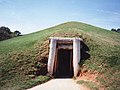
Ocmulgee Mounds National Historical Park in Macon, Georgia, United States preserves traces of over ten millennia of culture from the Native Americans in the Southeastern Woodlands. Its chief remains are major earthworks built before 1000 CE by the South Appalachian Mississippian culture These include the Great Temple and other ceremonial mounds, a burial mound, and defensive trenches. They represented highly skilled engineering techniques and soil knowledge, and the organization of many laborers. The site has evidence of "12,000 years of continuous human habitation." The 3,336-acre (13.50 km2) park is located on the east bank of the Ocmulgee River. Macon, Georgia developed around the site after the United States built Fort Benjamin Hawkins nearby in 1806 to support trading with Native Americans.

The Mississippian culture was a Native American civilization that flourished in what is now the Midwestern, Eastern, and Southeastern United States from approximately 800 CE to 1600 CE, varying regionally. It was known for building large, earthen platform mounds, and often other shaped mounds as well. It was composed of a series of urban settlements and satellite villages linked together by loose trading networks. The largest city was Cahokia, believed to be a major religious center located in what is present-day southern Illinois.

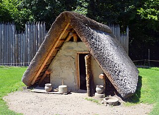
Fort Abraham Lincoln State Park is a North Dakota state park located 7 miles (11 km) south of Mandan, North Dakota, United States. The park is home to the replica Mandan On-A-Slant Indian Village and reconstructed military buildings including the Custer House.
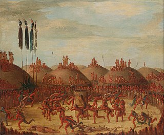
The Knife River Indian Villages National Historic Site, which was established in 1974, preserves the historic and archaeological remnants of bands of Hidatsa, Northern Plains Indians, in North Dakota. This area was a major trading and agricultural area. Three villages were known to occupy the Knife area. In general, these three villages are known as Hidatsa villages. Broken down, the individual villages are Awatixa Xi'e, Awatixa and Big Hidatsa village. Awatixa Xi'e is believed to be the oldest village of the three. The Big Hidatsa village was established around 1600.
A pit-house is a house built in the ground and used for shelter. Besides providing shelter from the most extreme of weather conditions, these structures may also be used to store food and for cultural activities like the telling of stories, dancing, singing and celebrations. General dictionaries also describe a pit-house as a dugout, and it has similarities to a half-dugout.
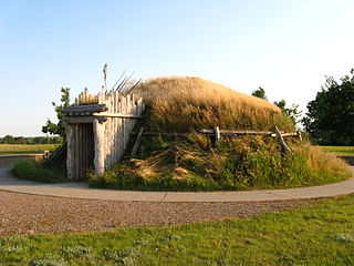
Like-a-Fishhook Village was a Native American settlement next to Fort Berthold in North Dakota, United States, established by dissident bands of the Three Affiliated Tribes, the Mandan, Arikara and Hidatsa. Formed in 1845, it was also eventually inhabited by non-Indian traders, and became important in the trade between Natives and non-Natives in the region.

A platform mound is any earthwork or mound intended to support a structure or activity. It typically refers to a flat-topped mound, whose sides may be pyramidal.
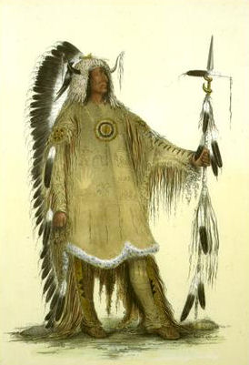
Mato-tope was the second chief of the Mandan tribe to be known as "Four Bears," a name he earned after charging the Assiniboine tribe during battle with the strength of four bears. Four Bears lived in the first half of the 19th century on the upper Missouri River in what is now North Dakota. Four Bears was a favorite subject of artists, painted by George Catlin and Karl Bodmer.

Fort Buford was a United States Army Post at the confluence of the Missouri and Yellowstone rivers in Dakota Territory, present day North Dakota, and the site of Sitting Bull's surrender in 1881.
Garden Creek site is an archaeological site located 24 miles (39 km) west of Asheville, North Carolina in Haywood County, on the south side of the Pigeon River and near the confluence of its tributary Garden Creek. It is near modern Canton and the Pisgah National Forest. The earliest human occupation at the site dates to 8000 BCE. The 12-acre site features remains of two villages (31Hw7) occupied first in the Woodland period and, most prominently, in the Pisgah phase associated with the South Appalachian Mississippian culture. A total of four earthwork mounds have been found at the site; three have been excavated.

Double Ditch, also known as the Double Ditch State Historic Site, Burgois Site, 32BL8, Bourgois Site, and Double Ditch Earth Lodge Village Site, is an archaeological site located on the east bank of the Missouri River north of Bismarck, North Dakota, United States. It is named for the two visible trenches that once served as fortifications for the village, but archaeologists found a further two ditches outside these indicating that the population was originally larger.
The Wilbanks Site (9CK5) is a Late Mississippian culture Native American archaeological site in Cherokee County, Georgia, United States. The site was located about midway between the towns of Cartersville, Georgia to the west, and Canton, Georgia to the east. It was on the south bank of the Etowah River, but is now submerged underneath Lake Allatoona, under roughly 80–90 feet of water.
The Mandeville site (9CY1) is an archaeological site in Clay County in southwest Georgia in the United States. The site now lies under the Walter F. George Reservoir, which is a part of the Chattahoochee River basin.
The Lamar mounds and village site (9BI2) is an important archaeological site on the banks of the Ocmulgee River in Bibb County, Georgia, several miles to the southeast of the Ocmulgee mound site. Both mound sites are part of the Ocmulgee Mounds National Historical Park, a national park and historic district created in 1936 and run by the U.S. National Park Service. Historians and archaeologists have theorized that the site is the location of the main village of the Ichisi encountered by the Hernando de Soto expedition in 1539.

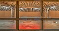
The Cahokia Woodhenge was a series of large timber circles located roughly 850 metres (2,790 ft) to the west of Monks Mound at the Mississippian culture Cahokia archaeological site near Collinsville, Illinois. They are thought to have been constructed between 900 and 1100 CE; with each one being larger and having more posts than its predecessor. The site was discovered as part of salvage archaeology in the early 1960s interstate highway construction boom, and one of the circles was reconstructed in the 1980s. The circle has been used to investigate archaeoastronomy at Cahokia. Annual equinox and solstice sunrise observation events are held at the site.
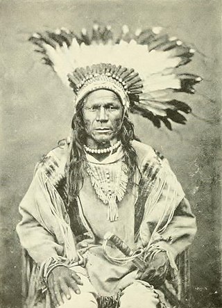
Crow Flies High was the chief of a band of dissident Hidatsa people from 1870 until their band joined the reservation system in 1894. This band was one of the last to settle on an Indian reservation. A North Dakota State Park is named after him.