East Punjab

Last updated

Province of East Punjab
Former province of India
1947–1950
Punjab, India (1956-1966).png
East Punjab, 1951
Capital Shimla [1]
Historical era20th century
 Established
1947
 PEPSU formed
1948
 Disestablished
1950
Preceded by
Succeeded by
British Raj Red Ensign.svg Punjab Province
Punjab State Punjab Flag (INDIA).png
Haryana ..Haryana Flag(INDIA).png
Himachal Pradesh Blank.png
Chandigarh Blank.png
PEPSU Blank.png
Today part of Punjab
Chandigarh
Haryana
Himachal Pradesh

East Punjab was a province of India from 1947 until 1950. It consisted parts of the Punjab province that remained in India following the partition of the province between the new dominions of Pakistan and the Indian Union by the Radcliffe Commission in 1947. The mostly Muslim western parts of the old Punjab became Pakistan's West Punjab, later renamed as Punjab Province, while the mostly Hindu and Sikh eastern parts remained with India.

Contents

History

Partition of India

With the partition of India, the Punjab province was to be divided in two as per the Indian Independence Act 1947, passed by the parliament of the United Kingdom. The province was to cease to exist, and two new provinces were to be constituted, to be known respectively as West Punjab & East Punjab. [2] All the princely states of the Punjab States Agency, except Bahawalpur, which acceded to the Dominion of Pakistan, acceded to the new Union of India and were combined into the Patiala and East Punjab States Union (PEPSU). The northeast Hill States of the Punjab Province banded together and were declared a union territory in 1950 as Himachal Pradesh.

Renaming of the state

Administrative divisions of India in 1951 India Administrative Divisions 1951.svg
Administrative divisions of India in 1951

The Constitution of India, which came into effect in 1950, renamed the province of "East Punjab" as the state of "Punjab".[ citation needed ]

Reorganisation of Indian States

In 1956, the PEPSU was merged into an expanded Punjab state.

Punjabi Suba movement

A map of the distribution of native Punjabi speakers in India and Pakistan Punjabispeakers.png
A map of the distribution of native Punjabi speakers in India and Pakistan

With effect from 1 November 1966, there was yet another reorganisation, this time on linguistic lines, when the state of Punjab as constituted in 1956 was divided into three: the mostly Hindi-speaking part became the present-day Indian state of Haryana and the mostly Punjabi-speaking part became the present-day Punjab, [3] [4] while a new union territory (Chandigarh) was also created, to serve as a capital to both states. At the same time, some parts of the former territory of Patiala and East Punjab States Union, including Solan and Nalagarh, were transferred to Himachal Pradesh.

Demography

1901 census

Religions in East Punjab, India region (1901) [5] :34 [6] :62 [lower-alpha 1]

   Hinduism (58.63%)
   Islam (29.54%)
   Sikhism (11.30%)
  Jainism (0.31%)
  Christianity (0.17%)
  Others [lower-alpha 2] (0.05%)

Prior to partition, the eastern portion of Punjab that was ultimately awarded to India following the demarcation of the Radcliffe Line was made into a new province – East Punjab. The area includes the contemporary states of Punjab, Haryana, and Himachal Pradesh. Below is the religious demographics of this region broken down by district and princely state with an overall total as per the 1901 Indian census.

Religion in the Districts & Princely States of East Punjab, India region (1901) [5] :34 [6] :62 [lower-alpha 1]
District/
Princely state
Hinduism Om.svg Islam Star and Crescent.svg Sikhism Khanda.svg Jainism Jain Prateek Chihna.svg Christianity Christian cross.svg Others [lower-alpha 2] Total
Pop. %Pop.%Pop.%Pop.%Pop.%Pop.%Pop.%
Patiala State 880,490357,334355,6492,877316261,596,692
Amritsar district 280,985474,976264,3291,4392,078211,023,828
Hoshiarpur district 603,710312,95871,1261,1738132989,782
Firozpur district 279,099447,615228,3551,0901,9085958,072
Jalandhar district 368,051421,011125,8179691,71326917,587
Karnal district 623,597241,41212,2944,7391,1794883,225
Ambala district 510,105240,71058,0732,6144,36216815,880
Hisar district 544,799202,00928,6426,00325311781,717
Kangra district 722,55439,6721,2201133854,180768,124
Gurgaon district 499,373242,548993,9092781746,208
Gurdaspur district [lower-alpha 3] 268,817348,18285,199723,57128705,869
Delhi District 510,532167,2902947,7263,15839689,039
Ludhiana district 269,076235,937164,9192,2179471673,097
Rohtak district 533,72391,687945,087801630,672
Simla Hill States 373,88611,5351,3182741132,223389,349
Kapurthala State 93,652178,32642,101226397314,351
Nabha State 160,55358,55078,36147672297,949
Jind State 211,96338,71729,9751,2588010282,003
Mandi State 170,3043,1874103510174,045
Nahan State 128,4786,41468861460135,687
Chamba State 119,3278,3328037022127,834
Faridkot State 35,77835,99652,721406110124,912
Malerkotla State 38,40927,22910,4951,36112077,506
Kalsia State 38,62621,9216,4531810067,181
Suket State 54,005665600054,676
Simla District 30,2996,675544322,798340,351
Dujana State 18,3805,790400024,174
Pataudi State 18,2813,54901030021,933
Loharu State 13,2541,9630120015,229
Total8,400,1064,232,1901,618,89744,42124,2207,13814,326,972
Territory comprises the contemporary subdivisions of Punjab, India, Chandigarh, Haryana, and Himachal Pradesh.

1911 census

Religions in East Punjab, India region (1911) [7] :27 [8] :27 [lower-alpha 4]

   Hinduism (54.48%)
   Islam (28.90%)
   Sikhism (15.82%)
  Christianity (0.42%)
  Jainism (0.31%)
  Others [lower-alpha 2] (0.06%)

Prior to partition, the eastern portion of Punjab that was ultimately awarded to India following the demarcation of the Radcliffe Line was made into a new province – East Punjab. The area includes the contemporary states of Punjab, Haryana, and Himachal Pradesh. Below is the religious demographics of this region broken down by district and princely state with an overall total as per the 1911 Indian census.

Religion in the Districts & Princely States of East Punjab, India region (1911) [7] :27 [8] :27 [lower-alpha 4]
District/
Princely state
Hinduism Om.svg Islam Star and Crescent.svg Sikhism Khanda.svg Christianity Christian cross.svg Jainism Jain Prateek Chihna.svg Others [lower-alpha 2] Total
Pop. %Pop.%Pop.%Pop.%Pop.%Pop.%Pop.%
Patiala State 563,940307,384532,2927393,282221,407,659
Firozpur district 273,832418,553262,5113,3421,40118959,657
Hoshiarpur district 498,642281,805134,1462,9789980918,569
Amritsar district 211,708408,882253,9414,7631,38648880,728
Hisar district 541,720218,60038,5082735,76721804,889
Jalandhar district 265,378357,051176,2272,40484218801,920
Karnal district 556,203224,92013,5319204,2130799,787
Kangra district 725,15638,8591,910386813,994770,386
Rohtak district 450,54986,0761613344,3690541,489
Ambala district 380,592205,20394,4717,4832,18734689,970
Delhi District 469,561171,7452,9855,6937,53981657,604
Gurgaon district 421,885217,2373427822,92110643,177
Gurdaspur district [lower-alpha 3] 190,965304,860110,52519,8797322626,324
Ludhiana district 131,370176,043207,0428881,8490517,192
Simla Hill States 386,95311,3742,9112241722,709404,343
Jind State 210,22237,52022,5661871,2330271,728
Kapurthala State 61,426152,11754,2751072053268,133
Nabha State 126,41446,03276,19852380248,887
Mandi State 178,1152,7992642164181,110
Nahan State 130,2766,0162,14237490138,520
Chamba State 126,2698,750141815627135,873
Faridkot State 37,37737,10555,39764090130,294
Malerkotla State 22,90225,94221,018141,268071,144
Kalsia State 30,64018,8206,25831160055,909
Suket State 54,2685877120054,928
Simla District 29,0475,8206933,666494539,320
Dujana State 20,1615,324000025,485
Pataudi State 16,1143,3380982019,543
Loharu State 16,1782,4010018018,597
Total7,127,8633,781,1632,070,28855,23740,7987,81613,083,165
Territory comprises the contemporary subdivisions of Punjab, India, Chandigarh, Haryana, and Himachal Pradesh.

1921 census

Religions in East Punjab, India region (1921) [9] :29 [lower-alpha 5]

   Hinduism (53.00%)
   Islam (29.05%)
   Sikhism (16.99%)
  Christianity (0.65%)
  Jainism (0.27%)
  Others [lower-alpha 2] (0.05%)

Prior to partition, the eastern portion of Punjab that was ultimately awarded to India following the demarcation of the Radcliffe Line was made into a new province – East Punjab. The area includes the contemporary states of Punjab, Haryana, and Himachal Pradesh. Below is the religious demographics of this region broken down by district and princely state with an overall total as per the 1921 Indian census.

Religion in the Districts & Princely States of East Punjab, India region (1921) [9] :29 [lower-alpha 5]
District/
Princely state
Hinduism Om.svg Islam Star and Crescent.svg Sikhism Khanda.svg Christianity Christian cross.svg Jainism Jain Prateek Chihna.svg Others [lower-alpha 2] Total
Pop. %Pop.%Pop.%Pop.%Pop.%Pop.%Pop.%
Patiala State 642,055330,341522,6751,3953,249241,499,739
Firozpur district 306,350482,540302,7615,3651,211211,098,248
Amritsar district 204,435423,724287,00412,7731,37563929,374
Hoshiarpur district 500,339289,298132,9583,7451,0790927,419
Karnal district 573,224235,61812,2803,3824,2220828,726
Jalandhar district 244,995366,586206,1304,0887369822,544
Hisar district 548,351215,94345,6151,0245,8743816,810
Rohtak district 629,592125,03560210,0337,0100772,272
Kangra district 722,27738,2632,083363563,023766,065
Gurgaon district 460,134216,8609241,3162,7627682,003
Ambala district 370,125205,75097,6145,6792,27237681,477
Gurdaspur district [lower-alpha 3] 168,178316,709125,32229,0992015639,343
Ludhiana district 135,512192,961235,7211,6131,79619567,622
Jind State 234,72143,25128,0266371,5480308,183
Simla Hill States 292,7689,5512,0401641422,053306,718
Kapurthala State 58,412160,45764,0741,1002284284,275
Nabha State 133,87050,75678,389412780263,334
Mandi State 181,3583,46214210076185,048
Faridkot State 38,61044,81366,6581074730150,661
Chamba State 130,48910,529242633541141,867
Nahan State 132,4316,4491,449446510140,448
Bilaspur State 96,0001,55943740098,000
Malerkotla State 29,45928,41321,82837585080,322
Kalsia State 28,76920,3948,0144190057,371
Suket State 53,6256594400054,328
Simla District 33,2286,9531,1733,823906045,327
Dujana State 20,1355,698000025,833
Loharu State 17,9782,6250018020,621
Pataudi State 15,0902,89800109018,097
Total7,002,5103,838,0952,244,20585,90935,3915,96513,212,075
Territory comprises the contemporary subdivisions of Punjab, India, Chandigarh, Haryana, and Himachal Pradesh.

1931 census

Religions in East Punjab, India region (1931) [10] :277 [lower-alpha 6]

   Islam (30.17%)
   Sikhism (20.01%)
  Christianity (0.65%)
  Jainism (0.25%)
  Others [lower-alpha 2] (0.05%)

Prior to partition, the eastern portion of Punjab that was ultimately awarded to India following the demarcation of the Radcliffe Line was made into a new province – East Punjab. The area includes the contemporary states of Punjab, Haryana, and Himachal Pradesh. Below is the religious demographics of this region broken down by district and princely state with an overall total as per the 1931 Indian census.

Religion in the Districts & Princely States of East Punjab, India region (1931) [10] :277 [lower-alpha 6]
District/
Princely state
Hinduism Om.svg [lower-alpha 7] Islam Star and Crescent.svg Sikhism Khanda.svg Christianity Christian cross.svg Jainism Jain Prateek Chihna.svg Others [lower-alpha 2] Total
Pop. %Pop.%Pop.%Pop.%Pop.%Pop.%Pop.%
Patiala State 623,597363,920632,9721,4493,57841,625,520
Firozpur district 244,688515,430388,1087,0701,411251,156,732
Amritsar district 174,556524,676399,95116,6191,272461,117,120
Hoshiarpur district 526,182328,078173,1473,7641,01601,032,187
Jalandhar district 268,822419,556249,5714,3231,37970943,721
Hisar district 583,429253,78455,1691,1075,9882899,479
Karnal district 570,297259,73016,9281,4694,1900852,614
Rohtak district 655,963137,8805964,8076,3750805,621
Kangra district 752,09840,4832,396576945,665801,312
Ambala district 346,809230,837155,5557,1412,55010742,902
Gurgaon district 493,174242,3575001,4632,6654740,163
Gurdaspur district [lower-alpha 3] 154,631367,388162,74138,756154723,535
Ludhiana district 120,161235,598312,8292,4771,41910672,494
Simla Hill States 317,39010,0171,8171761411,309330,850
Jind State 243,56146,00233,2902101,6130324,676
Kapurthala State 64,319179,25172,177983270316,757
Nabha State 132,35457,39397,452663090287,574
Mandi State 199,9356,3518991410139207,465
Faridkot State 20,85549,91292,8801675500164,364
Sirmoor State 139,0317,0202,41352520148,568
Chamba State 135,25410,839112943568146,870
Bilaspur State 99,0231,458507600100,994
Malerkotla State 21,25231,41728,9821351,286083,072
Kalsia State 28,83221,7979,03522162059,848
Suket State 57,61673344101458,408
Simla District 28,6615,8107601,54011436,786
Dujana State 22,3475,863150028,216
Loharu State 20,1983,1192118023,338
Pataudi State 15,5963,16813105018,873
Total7,060,6314,359,8672,890,83594,62336,2197,88414,450,059
Note: Territory comprises the contemporary subdivisions of Punjab, India, Chandigarh, Haryana, and Himachal Pradesh.

1941 census

Religions in East Punjab, India region (1941) [11] :42 [lower-alpha 8]

   Islam (30.88%)
   Sikhism (21.14%)
  Christianity (0.69%)
  Jainism (0.21%)
  Others [lower-alpha 2] (0.12%)

Prior to partition, the eastern portion of Punjab that was ultimately awarded to India following the demarcation of the Radcliffe Line was made into a new province – East Punjab. The area includes the contemporary states of Punjab, Haryana, and Himachal Pradesh. Below is the religious demographics of this region broken down by district and princely state with an overall total as per the 1941 Indian census.

Religion in the Districts & Princely States of East Punjab, India region (1941) [11] :42 [lower-alpha 8]
District/
Princely state
Hinduism Om.svg [lower-alpha 7] Islam Star and Crescent.svg Sikhism Khanda.svg Christianity Christian cross.svg Jainism Jain Prateek Chihna.svg Others [lower-alpha 2] Total
Pop. %Pop.%Pop.%Pop.%Pop.%Pop.%Pop.%
Patiala State 597,488436,539896,0211,5923,1011,5181,936,259
Firozpur district 287,733641,448479,48612,6071,6741281,423,076
Amritsar district 217,431657,695510,84525,9731,911211,413,876
Hoshiarpur district 584,080380,759198,1946,1651,12501,170,323
Jalandhar district 311,010509,804298,7416,2331,39571,127,190
Hisar district 652,842285,20860,7311,2926,1265101,006,709
Karnal district 666,301304,34619,8871,2492,7893994,575
Rohtak district 780,474166,5691,4661,0436,8470956,399
Kangra district 846,53143,2494,8097881013,899899,377
Gurdaspur district [lower-alpha 3] 174,221440,323200,68846,743256862,006
Gurgaon district 560,537285,9926371,6732,6136851,458
Ambala district 412,658268,999156,5436,0653,065415847,745
Ludhiana district 171,715302,482341,1751,9131,27951818,615
Kapurthala State 61,546213,75488,3501,66738012,683378,380
Jind State 268,35550,97240,9811611,29449361,812
Simla Hill States 345,71610,8122,69316112612359,520
Nabha State 146,51870,373122,4512214801344,044
Mandi State 227,4634,328583110208232,593
Faridkot State 21,81461,352115,0702478000199,283
Chamba State 155,91012,3181071900383168,908
Sirmoor State 146,1997,3742,33438810156,026
Bilaspur State 108,3751,498453730110,336
Malerkotla State 23,48233,88130,320116310088,109
Suket State 69,97488423400071,092
Kalsia State 29,86625,04912,23555188067,393
Simla District 29,4667,0221,032934114838,576
Dujana State 23,7276,939000030,666
Loharu State 23,9233,960720027,892
Pataudi State 17,7283,65509128021,520
Total7,963,0835,237,5843,586,073117,15535,95519,90816,959,758
Note: Territory comprises the contemporary subdivisions of Punjab, India, Chandigarh, Haryana, and Himachal Pradesh.

2011 census

Religion

Religion in East Punjab (2011) [12]

   Hinduism (65.94%)
   Sikhism (28.63%)
   Islam (4.13%)
  Others (1.3%)

East Punjab comprising the states of (Punjab, Haryana, Himachal Pradesh and Union territory of Chandigarh) had a population of 61,014,852 people as of 2011 census report of India. The Hindus form a majority in East Punjab region with 40,234,605 adherents comprising (65.94%), Sikhs are 17,466,731 comprising (28.62%) of the region, Muslims are 2,518,159 comprising (4.12%) of the region and others are 795,357 including Christians, Buddhists, Jains, and atheists together comprising remaining (1.3%) of the region. Sikhs are the majority in Punjab, while Hindus form the majority in Haryana, Himachal Pradesh, and Chandigarh. Muslims are majority in Nuh district of Haryana. [13]

Language

Languages spoken in East Punjab (2011) [14]

   Punjabi (46.16%)
   Hindi (26.64%)
   Haryanvi (15.44%)
   Pahari languages (7.53%)
  Others (4.23%)

As per 2011 census, Punjabi is the most spoken language and is spoken by 28,166,306 people, followed by Hindi which is spoken by 16,259,205 people, Haryanvi by 9,423,138 people and Western Pahari language by 4,599,283 people. While 2,580,928 people speaks other languages like Nepali. [15]

Modern usage

Since it ceased to be the name of a state, "East Punjab" has been used in India to refer to the eastern part of the present Punjab state, while in Pakistan it means the eastern part of Pakistan's Punjab province, although Pakistanis also sometimes refer to the current Indian Punjab as "East Punjab". [16] Terms East and West Punjab are also often used in modern India and Pakistan when making a comparison between the two territories.

See also

Notes

  1. 1 2 1901 figure taken from census data by combining the total population of all districts (Hisar, Rohtak, Gurgaon, Delhi, Karnal, Jalandhar, Ludhiana, Firozpur, Amritsar, Simla, Kangra, Ambala, Hoshiarpur, and Gurdaspur (minus Shakargarh Tehsil)), and princely states (Loharu, Dujana, Pataudi, Kalsia, Kapurthala, Malerkotla, Faridkot, Patiala, Jind, Nabha, Nahan, Simla Hill, Mandi, Suket, and Chamba) in Punjab Province, British India that ultimately fell on the eastern side of the Radcliffe Line. See 1901 census data here: [5] :34
    Immediately following the partition of India in 1947, these districts and princely states would ultimately make up the subdivision of East Punjab, which also included Patiala and East Punjab States Union, Chief Commissioner's Province of Himachal Pradesh, and Bilaspur State. The states that make up this region in the contemporary era are Punjab, India, Chandigarh, Haryana, and Himachal Pradesh.
  2. 1 2 3 4 5 6 7 8 9 10 Including Buddhism, Zoroastrianism, Judaism, Tribals, others, or not stated
  3. 1 2 3 4 5 Does not include Shakargarh Tehsil, which was awarded to Pakistan as part of the Radcliffe Line.
  4. 1 2 1911 figure taken from census data by combining the total population of all districts (Hisar, Rohtak, Gurgaon, Delhi, Karnal, Jalandhar, Ludhiana, Firozpur, Amritsar, Simla, Kangra, Ambala, Hoshiarpur, and Gurdaspur (minus Shakargarh Tehsil)), and princely states (Loharu, Dujana, Pataudi, Kalsia, Kapurthala, Malerkotla, Faridkot, Patiala, Jind, Nabha, Nahan, Simla Hill, Mandi, Suket, and Chamba) in Punjab Province, British India that ultimately fell on the eastern side of the Radcliffe Line. See 1911 census data here: [7] :27 [8] :27
    Immediately following the partition of India in 1947, these districts and princely states would ultimately make up the subdivision of East Punjab, which also included Patiala and East Punjab States Union, Chief Commissioner's Province of Himachal Pradesh, and Bilaspur State. The states that make up this region in the contemporary era are Punjab, India, Chandigarh, Haryana, and Himachal Pradesh.
  5. 1 2 1921 figure taken from census data by combining the total population of all districts (Hisar, Rohtak, Gurgaon, Karnal, Jalandhar, Ludhiana, Firozpur, Amritsar, Simla, Kangra, Ambala, Hoshiarpur, and Gurdaspur (minus Shakargarh Tehsil)), and princely states (Loharu, Dujana, Pataudi, Kalsia, Kapurthala, Malerkotla, Faridkot, Patiala, Jind, Nabha, Nahan, Simla Hill, Bilaspur, Mandi, Suket, and Chamba) in Punjab Province, British India that ultimately fell on the eastern side of the Radcliffe Line. See 1921 census data here: [9] :29
    Immediately following the partition of India in 1947, these districts and princely states would ultimately make up the subdivision of East Punjab, which also included Patiala and East Punjab States Union, Chief Commissioner's Province of Himachal Pradesh, and Bilaspur State. The states that make up this region in the contemporary era are Punjab, India, Chandigarh, Haryana, and Himachal Pradesh.
  6. 1 2 1931 figure taken from census data by combining the total population of all districts (Hisar, Rohtak, Gurgaon, Karnal, Jalandhar, Ludhiana, Firozpur, Amritsar, Simla, Kangra, Ambala, Hoshiarpur, and Gurdaspur (minus Shakargarh Tehsil)), and princely states (Loharu, Dujana, Pataudi, Kalsia, Kapurthala, Malerkotla, Faridkot, Patiala, Jind, Nabha, Sirmoor, Simla Hill, Bilaspur, Mandi, Suket, and Chamba) in Punjab Province, British India that ultimately fell on the eastern side of the Radcliffe Line. See 1931 census data here: [10] :277
    Immediately following the partition of India in 1947, these districts and princely states would ultimately make up the subdivision of East Punjab, which also included Patiala and East Punjab States Union, Chief Commissioner's Province of Himachal Pradesh, and Bilaspur State. The states that make up this region in the contemporary era are Punjab, India, Chandigarh, Haryana, and Himachal Pradesh.
  7. 1 2 3 4 Including Ad-Dharmis
  8. 1 2 1941 figure taken from census data by combining the total population of all districts (Hisar, Rohtak, Gurgaon, Karnal, Jalandhar, Ludhiana, Firozpur, Amritsar, Simla, Kangra, Ambala, Hoshiarpur, and Gurdaspur (minus Shakargarh Tehsil)), and princely states (Loharu, Dujana, Pataudi, Kalsia, Kapurthala, Malerkotla, Faridkot, Patiala, Jind, Nabha, Sirmoor, Simla Hill, Bilaspur, Mandi, Suket, and Chamba) in Punjab Province, British India that ultimately fell on the eastern side of the Radcliffe Line. See 1941 census data here: [11] :42
    Immediately following the partition of India in 1947, these districts and princely states would ultimately make up the subdivision of East Punjab, which also included Patiala and East Punjab States Union, Chief Commissioner's Province of Himachal Pradesh, and Bilaspur State. The states that make up this region in the contemporary era are Punjab, India, Chandigarh, Haryana, and Himachal Pradesh.

Related Research Articles

<span class="mw-page-title-main">Punjab</span> Geographical region in South Asia

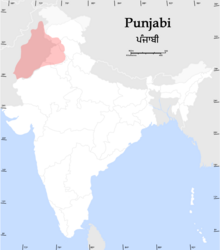
Punjab is a geopolitical, cultural, and historical region in South Asia. It is specifically located in the northwestern part of the Indian subcontinent, comprising areas of modern-day eastern-Pakistan and northwestern-India. Punjab's major cities are Lahore, Faisalabad, Rawalpindi, Gujranwala, Multan, Ludhiana, Amritsar, Sialkot, Chandigarh, Shimla, Jalandhar, Patiala, Gurugram, and Bahawalpur.

<span class="mw-page-title-main">Partition of India</span> 1947 division of British India

The Partition of India in 1947 was the change of political borders and the division of other assets that accompanied the dissolution of the British Raj in the Indian subcontinent and the creation of two independent dominions in South Asia: India and Pakistan. The Dominion of India is today the Republic of India, and the Dominion of Pakistan—which at the time comprised two regions lying on either side of India—is now the Islamic Republic of Pakistan and the People's Republic of Bangladesh. The partition was outlined in the Indian Independence Act 1947. The change of political borders notably included the division of two provinces of British India, Bengal and Punjab. The majority Muslim districts in these provinces were awarded to Pakistan and the majority non-Muslim to India. The other assets that were divided included the British Indian Army, the Royal Indian Navy, the Royal Indian Air Force, the Indian Civil Service, the railways, and the central treasury. Provisions for self-governing independent Pakistan and India legally came into existence at midnight on 14 and 15 August 1947 respectively. The Partition of India was one of deadliest partition with most destructive and huge migration between the two independent countries with millions of people been killed and millions been displaced.

<span class="mw-page-title-main">West Punjab</span> Former province of Pakistan from 1947 to 1955

West Punjab was a province in the Dominion of Pakistan from 1947 to 1955. It was established from the western-half of British Punjab, following the independence of Pakistan. The province covered an area of 159,344 km sq, including much of the current Punjab province and the Islamabad Capital Territory, but excluding the former Princely state of Bahawalpur. Lahore, being the largest city and the cultural centre, served as the capital of the province. The province was composed of four divisions and was bordered by the state of Bahawalpur to the south-east, the province of Baluchistan to the south-west and Sind to the south, North-West Frontier Province to the north-west, and Azad Jammu and Kashmir to the north. It shared International border with Indian state of East Punjab to the east and Indian-administered Jammu & Kashmir to the north-east. It was dissolved and merged into West Pakistan upon creation of One Unit Scheme, in 1955.

<span class="mw-page-title-main">Patiala and East Punjab States Union</span> Former State of India

The Patiala and East Punjab States Union (PEPSU) was a state of India, uniting eight princely states between 1948 and 1956. The capital and principal city was Patiala. The state covered an area of 26,208 km2. Shimla, Kasauli, Kandaghat and Chail also became part of PEPSU.

<span class="mw-page-title-main">Malerkotla</span> City in Punjab, India

Malerkotla is a city and the district headquarters of Malerkotla district in the Indian state of Punjab. It served as the seat of the eponymous princely state during the British Raj. The state acceded to the union of India in 1947 and was merged with other nearby princely states to form the Patiala and East Punjab States Union (PEPSU).

<span class="mw-page-title-main">Gurdaspur district</span> District in Punjab, India

Gurdaspur district is a district in the Majha region of the state of Punjab, India. Gurdaspur is the district headquarters. It internationally borders Narowal District of Pakistani Punjab, and the districts of Amritsar, Pathankot, Kapurthala and Hoshiarpur. Two main rivers Beas and Ravi passes through the district. The Mughal emperor Akbar is said to have been enthroned in a garden near Kalanaur, a historically important town in the district. The district is at the foothills of the Himalayas.

<span class="mw-page-title-main">Punjab Province (British India)</span> Province of British India

British Punjab was a province of British India. Most of the Punjab region was annexed by the British East India Company on 29 March 1849, and declared a province of British colonial rule; it was one of the last areas of the Indian subcontinent to fall under British control. In 1858, the Punjab, along with the rest of British Raj, came under the direct colonial rule of the British Crown. It had a land area of 358,355 square kilometers.

The Hill States of India were princely states lying in the northern border regions of the British Indian Empire.

<span class="mw-page-title-main">Bilaspur State (princely state)</span> Princely state of British India

Bilaspur State or Kahlur State, sometimes Kahloor Riyasat, was a kingdom (697–1849) and later princely state (1849–1948) in the Punjab Province ruled by a separate branch of Chandravanshi Chandel rajput dynasty. Raja Bir Chand 697–730 was the founder of the state but it was named Kahlur only after the Construction of Kahlur Fort by Raja Kahal Chand around 890–930CE and Raja Anand Chand the 44th Raja was the last ruler.

<span class="mw-page-title-main">Sikhism in Pakistan</span> Overview of the role and impact of Sikhism in Pakistan

Sikhism in Pakistan has an extensive heritage and history, although Sikhs form a small community in Pakistan today. Most Sikhs live in the province of Punjab, a part of the larger Punjab region where the religion originated in the Middle Ages, with some also residing in Peshawar in the Khyber-Pakhtunkhwa province. Nankana Sahib, the birthplace of Guru Nanak, the founder of Sikhism, is located in Pakistan's Punjab province. Moreover, the place where Guru Nanak died, the Gurudwara Kartarpur Sahib is also located in the same province.

<span class="mw-page-title-main">Punjab States Agency</span> Agency of British India

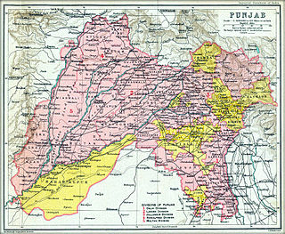
The Punjab States Agency was an agency of the British Raj. The agency was created in 1921, on the model of the Central India Agency and Rajputana Agency, and dealt with forty princely states in northwest India formerly dealt with by the Province of Punjab.

Chhachhrauli is a tehsil and Gram Panchayat town consisting of 20 wards in Yamuna Nagar district in the state of Haryana, India. It is 11 km north-east of Jagadhari. Chachhraulli is often known as "Cherapunjii of Haryana" as it receives the most rain in the whole of Haryana . It was a municipal committee until 1998. Before independence in 1947, it was the capital of the princely state of Kalsia. The origin of word Chhachhrauli is believed to be "Sat Sherawali" due to a temple located near bus terminus.

<span class="mw-page-title-main">Puadh</span> Historic region in north India

Puadh is a historic region in north India that comprises parts of present-day Punjab, Haryana, Uttar Pradesh, Himachal Pradesh and the U.T. of Chandigarh, India. It has the Sutlej river in its north and covers the regions immediately south of the Ghaggar river. The people of the area are known as Puadhi and speak the Puadhi dialect of Punjabi. The capital cities of Puadh region are Rupnagar, Fatehgarh Sahib, Mohali, Patiala, Chandigarh, Nalagarh,Panchkula, Baddi ,Ambala, Yamunanagar

Shakargarh, is a tehsil located in Narowal District, Punjab, Pakistan. Shakargarh was the only tehsil of Gurdaspur district which was included in Pakistan at the time of the independence in 1947. The literacy rate of Shakargarh is more than 97.6%, the highest in Pakistan. Pakistan Standard Time is referenced from Shakargarh.

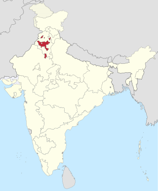
Punjab is home to 2.3% of India's population; with a density of 551 persons per km2. According to the provisional results of the 2011 national census, Punjab has a population of 27,743,338, making it the 16th most populated state in India. Of which male and female are 14,639,465 and 13,103,873 respectively. 32% of Punjab's population consists of Dalits. In the state, the rate of population growth is 13.9% (2011), lower than national average. Out of total population, 37.5% people live in urban regions. The total figure of population living in urban areas is 10,399,146 of which 5,545,989 are males and while remaining 4,853,157 are females. The urban population in the last 10 years has increased by 37.5%. According to the 2011 Census of India, Punjab, India has a population of around 27.7 million.

Religion in the Punjab in ancient history was characterized by Hinduism and later conversions to Jainism, Buddhism, Islam, Sikhism and Christianity; it also includes folk practices common to all Punjabis regardless of the religion they adhere to. Such practices incorporate local mysticism, including ancestral worship and worship of local saints of all faiths.

<span class="mw-page-title-main">Loharu State</span> Princely state of India

Loharu State was one of the princely states of India during the period of the British Raj. It was part of the Punjab States Agency and was a nine-gun salute state.

<span class="mw-page-title-main">Suket State</span> Princely state of India

Suket State was one of the Princely states of India during the period of the British Raj. The capital of the state was Pangna. Its last ruler signed the accession to the Indian Union on 15 April 1948. Formerly it belonged to the States of the Punjab Hills and currently, it is part of the Indian state of Himachal Pradesh. The present-day Mandi district was formed with the merger of the two princely states of Mandi and Suket.

<span class="mw-page-title-main">Islam in Punjab, India</span>

Islam is a minority religion in Punjab, India followed by 535,489 people constituting about 1.93 percent of the state population out of 27.7 million population as of 2011 census report.

<span class="mw-page-title-main">Hinduism in Punjab, Pakistan</span> Overview of the role and impact of Hinduism in the Pakistani province of Punjab

Hinduism is a minority religion in Punjab province of Pakistan followed by about 0.2% of its population. Punjab has the second largest number of Hindus in Pakistan after Sindh. Hinduism is followed mainly in the Southern Punjab districts of Rahim Yar Khan and Bahawalpur.

References

  1. Shimla Then & Now. Indus Publishing. 1 January 1996. ISBN   9788173870460 via Google Books.
  2. "Salient features of the act" (PDF). Retrieved 9 February 2013.
  3. S. Gajrani, History, Religion and Culture of India (2004), p. 217
  4. "Punjab Legislative Assembly". Archived from the original on 13 January 2012. Retrieved 22 December 2011.
  5. 1 2 3 "Census of India 1901. [Vol. 17A]. Imperial tables, I-VIII, X-XV, XVII and XVIII for the Punjab, with the native states under the political control of the Punjab Government, and for the North-west Frontier Province". 1901. JSTOR   saoa.crl.25363739 . Retrieved 10 March 2024.
  6. 1 2 "Punjab District Gazetteers Gurdaspur District Vol.21 Statistical Tables". 1913. Retrieved 10 March 2024.
  7. 1 2 3 "Census of India 1911. Vol. 14, Punjab. Pt. 2, Tables". 1911. JSTOR   saoa.crl.25393788 . Retrieved 3 March 2024.
  8. 1 2 3 Kaul, Harikishan (1911). "Census Of India 1911 Punjab Vol XIV Part II" . Retrieved 3 March 2024.
  9. 1 2 3 "Census of India 1921. Vol. 15, Punjab and Delhi. Pt. 2, Tables". 1921. JSTOR   saoa.crl.25430165 . Retrieved 17 February 2024.
  10. 1 2 3 "Census of India 1931. Vol. 17, Punjab. Pt. 2, Tables". 1931. JSTOR   saoa.crl.25793242 . Retrieved 4 February 2024.
  11. 1 2 3 India Census Commissioner (1941). "Census of India, 1941. Vol. 6, Punjab". JSTOR   saoa.crl.28215541 . Retrieved 19 January 2023.
  12. https://censusindia.gov.in/nada/index.php/catalog/11361 [ bare URL ]
  13. https://censusindia.gov.in/nada/index.php/catalog/11361 [ bare URL ]
  14. https://censusindia.gov.in/nada/index.php/catalog/10191 [ bare URL ]
  15. https://censusindia.gov.in/nada/index.php/catalog/10191 [ bare URL ]
  16. "Ties will grow, says Indian Punjab CM". 31 January 2004.