Patiala State

Last updated

State of Patiala
1763–1947
Crest of Patiala State.png
Coat of arms
Capital Patiala
Common languages Punjabi (official)
Religion
Sikh
Government Absolute monarchy
Maharaja  
 1707 - 1765
Ala Singh
 1938 - 1947
Yadavindra Singh
History 
 Established
1763
 Disestablished
1947
Area
 Total
15,389 km2 (5,942 sq mi)
Population
 1881 [1]
1,467,433
 1891 [1]
1,583,521
 1901 [1]
1,596,692
Currency Rupee And Paisa
Preceded by
Succeeded by
Blank.png Mughal Empire
Blank.png Durrani Empire
Blank.png Phulkian Misl
East India Company Blank.png
Sikh Empire Blank.png
PEPSU Blank.png
Republic of India Blank.png
Today part ofIndia
Pakistan

Patiala State was a self-governing princely state of the Empire of India, and one of the Phulkian States, that acceded to the Union of India upon Indian dominionship and partition. Patiala Kingdom/State was founded by Sidhu Jat Sikhs.

Contents

Early proposals of a Sikh nation of ‘Sikhistan’ led by Maharaja of Patiala were published by Dr VS Bhatti in 1940 for a “Khalistan led by the Maharaja of Patiala with the aid of a cabinet consisting of representative federating units”. [2] [3] [4] [5] These would consist of the central districts of Punjab province then directly administered by the British, including Ludhiana, Jalandhar, Ambala, Ferozpur, Amritsar and Lahore; the 'princely states' of the Cis-Sutlej, including Patiala, Nabha, Faridkot and Malerkolta; and the 'Shimla Group' of states. After partition of India in 1947, The Liberator, a Sikh publication advocated for Khalistan which would include East Punjab merged with PEPSU led by Maharaja of Patiala as its monarch. [6]

Etymology

The state's name came from the name of its principal city and capital, Patiala, which itself comes from the roots patti and ala. The word patti means "strip of land" in Punjabi, and 'ala' comes from the name of the founder of the city and Patiala state, Ala Singh, thus meaning ‘the land of Ala Singh’ [7]

1946 map of India showing the various states; Patiala is found in the middle of eastern Punjab 1946 Political Subdivisions of India by National Geographic.jpg
1946 map of India showing the various states; Patiala is found in the middle of eastern Punjab

Brief history

In 1763, the Sikh confederation captured the fortress of Sirhind

Rulers

The rulers of Patiala bore the title 'Maharaja-e Rajgan' from 1810 onward.[ citation needed ]

Maharajas

  • 29 Mar 1761 – 22 August 1765: Ala Singh (b. 1691 – d. 1765)
  • 22 Aug 1765 – 1767:Amar Singh (b. 1748 – d. 1781)

Raja-e Rajgan

  • 1767 – 5 February 1781: Amar Singh (s.a.)
  • Feb 1781 – 1810: Sahib Singh (b. 1774 – d. 1813)

Maharaja-e Rajgan

  • 1810 – 26 March 1813: Sahib Singh (s. a.)
  • 26 Mar 1813 – 23 December 1845: Karam Singh (b. 1797 – d. 1845)
    • 26 Mar 1813 – 1823: Maharani Aus Kaur (f) – Regent (b. 1772 – d. af.1823)
  • 23 Dec 1845 – 13 November 1862: Narendra Singh (b. 1823 – d. 1862) (from 25 June 1861 Sir Narendra Singh)
  • 13 Nov 1862 – 14 April 1876: Mahendra Singh (b. 1852 – d. 1876) (from 28 May 1870 Sir Mahendra Singh)
    • 13 Nov 1862 – 26 February 1870: Jagdish Singh (Regent, chairman of regency council)
  • 14 Apr 1876 – 9 November 1900: Rajinder Singh (b. 1872 – d. 1900) (from 21 May 1898 Sir Rajendra Singh)
    • 14 April 1876 – Oct 1890: Sir Deva Singh (Regent) (b. 1834 – d. 1890) (chairman of regency council)
  • 9 November 1900 – 23 March 1938: Bhupinder Singh (b. 1891 – d. 1938) (from 12 December 1911 Sir Bhupindra Singh)
    • 9 November 1900 – 3 November 1910: Sardar Gurmukh Singh – (Regent, chairman of regency council)
  • 23 Mar 1938 – 15 August 1947: Yadavindra Singh (b. 1913 – d. 1974) (from 1 January 1942 Sir Yadavindra Singh)

Demographics

Religious groups in Patiala State (British Punjab province era)
Religious
group
1901 [8] 1911 [9] [10] 1921 [11] 1931 [12] 1941 [13]
Pop. %Pop.%Pop.%Pop.%Pop.%
Hinduism Om.svg [lower-alpha 1] 880,490563,940642,055623,597597,488
Islam Star and Crescent.svg 357,334307,384330,341363,920436,539
Sikhism Khanda.svg 355,649532,292522,675632,972896,021
Jainism Jain Prateek Chihna.svg 2,8773,2823,2493,5783,101
Christianity Christian cross.svg 3167391,3951,4491,592
Zoroastrianism Faravahar.svg 262221221
Buddhism Dharma Wheel (2).svg 00323
Judaism Star of David.svg 000012
Others00001,482
Total population1,596,6921,407,6591,499,7391,625,5201,936,259
Note: British Punjab province era district borders are not an exact match in the present-day due to various bifurcations to district borders — which since created new districts — throughout the historic Punjab Province region during the post-independence era that have taken into account population increases.

See also

Notes

  1. 1931-1941: Including Ad-Dharmis

Related Research Articles

<span class="mw-page-title-main">Patiala</span> City in Punjab, India

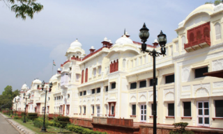
Patiala is a city in southeastern Punjab, northwestern India. It is the fourth largest city in the state and is the administrative capital of Patiala district. Patiala is located around the Qila Mubarak constructed by the Sidhu Jat Sikh chieftain Ala Singh, who founded the royal dynasty of Patiala State in 1763, and after whom the city is named.

<span class="mw-page-title-main">Jind district</span> District of Haryana in India

Jindo district is one of the 22 districts of Haryana state in northern India. Jind town is the administrative headquarters of the district. It is part of Hisar Division and was created in 1966.

<span class="mw-page-title-main">Hoshiarpur</span> City in Punjab, India

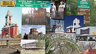
Hoshiarpur is a city and a municipal corporation in Hoshiarpur district in the Doaba region of the Indian state of Punjab. It was founded, according to tradition, during the early part of the fourteenth century. In 1809, it was occupied by the forces of Maharaja Karanvir Singh and was united into the greater state of Punjab in 1849.

<span class="mw-page-title-main">Patiala district</span> District in Punjab, India

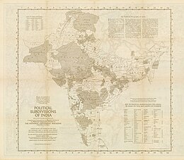
Patiala district is one of the twenty three districts in the state of Punjab in north-west India.

<span class="mw-page-title-main">Maharaja of Patiala</span> India Princely State

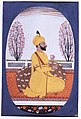
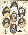
The Maharaja of Patiala was the title of a Maharaja in India and the ruler of the princely state of Patiala, a state in British India. The first Maharaja of Patiala was Baba Ala Singh (1695–1765).

<span class="mw-page-title-main">Bhupinder Singh of Patiala</span> Maharaja of Patiala (r. 1900–1938) and cricket player

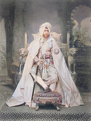
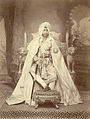
Maharaja Sir Bhupinder Singh, was an Indian royal and cricket player. He was the ruling Maharaja of the princely state of Patiala in British India from 1900 to 1938. He was born in a Sidhu royal Jat Sikh family.

<span class="mw-page-title-main">Kalsia</span>

Kalsia was a princely state in Punjab, British India, one of the former Cis-Sutlej states. It was founded by Gurbaksh Singh Kalsia in 1760. After India's independence, it was included in PEPSU and later in the Indian East Punjab after the States Reorganisation Act, 1956. The area of Kalsia is now located in the modern day Indian states of Punjab and Haryana. In 1940 the population of Kalsia was 67,393. Kalsia was ruled by Jat Sikhs.

<span class="mw-page-title-main">Yadavindra Singh</span> Last ruling Indian Maharaja of Patiala from 1938–1947

Yadavindra Singh was the ninth and last ruling Maharaja of Patiala from 1938 to 1971. He was also a diplomat, sports administrator and former cricketer who played in one Test in 1934.

<span class="mw-page-title-main">Rajinder Singh of Patiala</span> Maharaja of Patiala from 1876–1900

Sir Rajinder Singh was the Maharaja of the princely state of Patiala from 1876 to 1900. In 1897, he was awarded the Grand Cross of the Star of India for his bravery, by the colonial government. Described as "the first reigning Prince to blend the elements of the English gentleman and Indian potentate."

<span class="mw-page-title-main">Sirmur State</span> Princely state of India

Sirmur was an independent kingdom in India, founded in 1616, located in the region that is now the Sirmaur district of Himachal Pradesh. The state was also known as Nahan, after its main city, Nahan. The state ranked predominant amongst the Punjab hill States. It had an area of 4,039 km2 and a revenue of 300,000 rupees in 1891.

<span class="mw-page-title-main">Moti Bagh Palace</span> Royal palace in Punjab, India

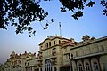
Moti Bagh Palace is a palace in Patiala, also known as Pearl Garden Palace. The word "Moti" means "pearl", and "Bagh" means "garden". The Palace was built by Maharaja Narinder Singh, the great-grandfather of Maharaja Bhupinder Singh, in 1847, at a cost of five lakhs of rupees. The Old Moti Bagh Palace and New Moti Bagh Palace were built respectively by Maharaja Narinder Singh and Maharaja Yadavindra Singh.

<span class="mw-page-title-main">Phulkian dynasty</span> Punjabi Rulers

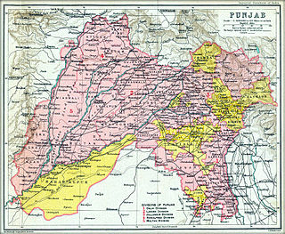
The Phulkian Dynasty of Maharajas or sardars were Jat-Sikh rulers and aristocrats in the Punjab region of India. They governed the states of Faridkot, Jind, Nabha, Malaudh, Bhadaur, Badrukhan and Patiala, allying themselves with the British Raj as per the Cis-Sutlej treaty. The Phulkain sardars are the descendants of Rawal Jaisal of Jaisalmer, who migrated to present day Malwa region of Punjab. The Phulkian dynasty claimed descent from Rawal Jaisal, the Bhati Rajput founder of Jaisalmer.

<span class="mw-page-title-main">Nabha State</span> Phulkian princely state of Punjab during the British Raj in India

Nabha State, with its capital at Nabha, was one of the Phulkian princely states of Punjab during the British Raj in India. Nabha was ruled by Jat Sikhs of the Sidhu clan.

<span class="mw-page-title-main">Faridkot State</span> Princely state of India

Faridkot State was a self-governing princely state of Punjab outside British India during the British Raj period in the Indian sub-continent until Indian independence.

<span class="mw-page-title-main">Mehtab Kaur of Patiala</span> Indian politician

Mehtab Kaur, was the second wife of the ninth and the last Maharaja of Patiala Yadavindra Singh (1913–1974). She was the mother of Amarinder Singh, the former Chief Minister of Punjab. Had it not been for the erstwhile Indian princely families being stripped of their titles in 1971, upon the death of her husband she would have been considered Rajmata, and in popular usage is commonly referred to as such.

Sardar Nanu Singh Saini was a Sikh army general and a well-known jagirdar in Phulkian riyasat. He was a close associate of Maharaja Ala Singh who founded the Patiala state in 1753 AD.

It is estimated that the city of Lahore, Pakistan, has a Muslim majority with 94.7% and Christian minority constitute 5.1% of the population and rest Sikhs and Hindus constitute the remaining 0.2%. There is also a small but longstanding Zoroastrian community.

<span class="mw-page-title-main">Jind State</span> Princely state of India

Jind State was a princely state located in the Punjab region of north-western India. The state was 3,260 km2 (1,260 sq mi) in area and its annual income was Rs.3,000,000 in the 1940s. Jind was founded and ruled by Jat Sikh rulers of Sidhu clan.

<span class="mw-page-title-main">Malerkotla State</span> Indian princely state

The State of Malerkotla or Maler Kotla was established by Maharaja of Parmar Rajputs, is a princely state in the Punjab region since the era of British India. Which was taken over by Sarwani and Lodi Pashtun dynasty from Afghanistan, and named Malerkotla as capital.

<span class="mw-page-title-main">Ala Singh</span>

Ala Singh (1691–1765) was the first king of the princely state of Patiala.

References

  1. 1 2 3 Imperial gazetteer of India. Vol. XX Pardi to Pusad. 1908. pp. 40, 42.
  2. Shani, Giorgio (2007). Sikh Nationalism and Identity in a Global Age. doi:10.4324/9780203937211. ISBN   9781134101894.
  3. Shani, Giorgio (6 December 2007). Sikh Nationalism and Identity in a Global Age. Routledge. ISBN   978-1-134-10188-7.
  4. Archives, The National. "The National Archives - Homepage". The National Archives. Retrieved 14 October 2022.
  5. Pathak, Ritika (12 December 2020). "Khalistan movement: Origin and the two different narratives". Newshour Press. Retrieved 14 October 2022.
  6. Singh, Amar. "Let Patiala Lead The Panth To Glory". National Achieves UK.
  7. Kaur, Roopam Jasmeet; Idris, Mohammad (2011). "The Development of Education in Patiala District (1948-2001): A Gendered Analysis". Proceedings of the Indian History Congress. 72: 1460–1470. JSTOR   44145757.
  8. "Census of India 1901. [Vol. 17A]. Imperial tables, I-VIII, X-XV, XVII and XVIII for the Punjab, with the native states under the political control of the Punjab Government, and for the North-west Frontier Province". 1901. p. 34. JSTOR   saoa.crl.25363739 . Retrieved 30 March 2024.
  9. "Census of India 1911. Vol. 14, Punjab. Pt. 2, Tables". 1911. p. 27. JSTOR   saoa.crl.25393788 . Retrieved 30 March 2024.
  10. Kaul, Harikishan (1911). "Census Of India 1911 Punjab Vol XIV Part II". p. 27. Retrieved 30 March 2024.
  11. "Census of India 1921. Vol. 15, Punjab and Delhi. Pt. 2, Tables". 1921. p. 29. JSTOR   saoa.crl.25430165 . Retrieved 30 March 2024.
  12. "Census of India 1931. Vol. 17, Punjab. Pt. 2, Tables". 1931. p. 277. JSTOR   saoa.crl.25793242 . Retrieved 30 March 2024.
  13. "Census of India, 1941. Vol. 6, Punjab". 1941. p. 42. JSTOR   saoa.crl.28215541 . Retrieved 30 March 2024.


Further reading

31°07′N77°38′E / 31.117°N 77.633°E / 31.117; 77.633