
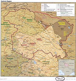
Kashmir is the northernmost geographical region of the Indian subcontinent. Until the mid-19th century, the term "Kashmir" denoted only the Kashmir Valley between the Great Himalayas and the Pir Panjal Range. Today, the term encompasses a larger area that includes the India-administered territories of Jammu and Kashmir and Ladakh, the Pakistan-administered territories of Azad Kashmir and Gilgit-Baltistan, and the Chinese-administered territories of Aksai Chin and the Trans-Karakoram Tract.

The history of Kashmir is intertwined with the history of the broader Indian subcontinent in South Asia with influences from the surrounding regions of Central, and East Asia. Historically, Kashmir referred to only the Kashmir Valley of the western Himalayas. Today, it denotes a larger area that includes the Indian-administered union territories of Jammu and Kashmir and Ladakh, the Pakistan-administered territories of Azad Kashmir and Gilgit-Baltistan, and the Chinese-administered regions of Aksai Chin and the Trans-Karakoram Tract.

Gilgit is a city in Pakistani-administered Gilgit–Baltistan in the disputed Kashmir region. It is the capital of the Gilgit-Baltistan region. The city is located in a broad valley near the confluence of the Gilgit and the Hunza rivers. It is a major tourist destination in Pakistan, serving as a hub for trekking and mountaineering expeditions in the Karakoram mountain range.

Kargil district is a district in Indian-administered Ladakh in the disputed Kashmir-region. It is one of the two districts comprising the Indian-administered union territory of Ladakh. The district headquarters are in the city of Kargil. The district is bounded by the Indian-administered union territory of Jammu and Kashmir to the west, the Pakistani-administered administrative territory of Gilgit–Baltistan to the north, Ladakh's Leh district to the east, and the Indian state of Himachal Pradesh to the south. Encompassing three historical regions known as Purig, Dras and Zanskar, the district lies to the northeast of the Great Himalayas and encompasses the majority of the Zanskar Range. Its population inhabits the river valleys of the Dras, Suru, Wakha Rong, and Zanskar.

Skardu is a city located in Pakistan-administered Gilgit-Baltistan in the disputed Kashmir region. Skardu serves as the capital of Skardu District and the Baltistan Division. It is situated at an average elevation of nearly 2,500 metres above sea level in the Skardu Valley, at the confluence of the Indus and Shigar rivers. The city is an important gateway to the eight-thousanders of the nearby Karakoram mountain range. The Indus River running through the region separates the Karakoram from the Ladakh Range.

The Gilgit Agency was an agency within the British Indian Empire. It encompassed the subsidiary states of the princely state of Jammu and Kashmir situated along the northern border. The primary objective of establishing the Gilgit Agency was to bolster and fortify these regions, particularly in the context of concerns about Russian encroachment in the area. The subsidiary states encompassed Hunza, Nagar and other states in the present day districts of Gupis-Yasin, Ghizer, Darel, Tangir and Diamer. The agency headquarters was based in the town of Gilgit, within the Gilgit tehsil of Jammu and Kashmir.

Bagh District is a district of Pakistan-administered Azad Kashmir in the disputed Kashmir region. It is one of the ten districts of Azad Jammu and Kashmir. Previously part of Poonch District, Bagh was established as a separate district in 1988.
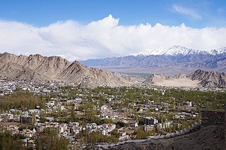
Leh district is a district in Indian-administered Ladakh in the disputed Kashmir-region. Ladakh is an Indian-administered union territory. With an area of 45,110 km2, it is the second largest district in the country, second only to Kutch. It is bounded on the north by Gilgit-Baltistan's Kharmang and Ghanche districts and Xinjiang's Kashgar Prefecture and Hotan Prefecture, to which it connects via the historic Karakoram Pass. Aksai Chin and Tibet are to the east, Kargil district to the west, and Lahul and Spiti to the south. The district headquarters is in Leh. It lies between 32 and 36 degree north latitude and 75 to 80 degree east longitude.
Pulwama is a city and notified area council in the Pulwama district of Indian-administered Jammu and Kashmir in the disputed Kashmir region. It is located approximately 25 kilometres (16 mi) south of the summer capital of the state, Srinagar.

Kargil or Kargyil is a city in Indian-administered Ladakh in the disputed Kashmir region. It is the joint capital of Ladakh, an Indian-administered union territory. It is also the headquarters of the Kargil district. It is the second-largest city in Ladakh after Leh. Kargil is located 204 kilometres (127 mi) east of Srinagar in Jammu and Kashmir, and 234 kilometres (145 mi) to the west of Leh. It is on the bank of the Suru River near its confluence with the Wakha Rong river, the latter providing the most accessible route to Leh.

Rajouri is a district in the Jammu division of Indian-administered Jammu and Kashmir in the disputed Kashmir region. The Line of Control, between the Indian- and Pakistani-administered Jammu and Kashmir, lies to its west, Poonch to its north, the Reasi district to the east and the Jammu district to its south. Rajouri is famous for its "Kalari". Representing an ancient principality, Rajouri was a joint district, along with Reasi, at the time of princely state's accession to India in 1947. The two tehsils were separated and Rajouri was merged with the Poonch district. Rajouri again became a separate district along with Reasi in 1968 till 2006 when both were separated again. The Rajouri district comprises 13 tehsils (boroughs). The land is mostly fertile and mountainous. Maize, wheat and rice are the main crops of the area and the main source of the irrigation is the river Tawi that originates from the mountains of Pir Panjal.

Bhimber is a town and the headquarters of the eponymous district in Pakistan-administered Azad Kashmir. The town and district are between the Jammu region of Indian-administered Kashmir and Pakistan proper, about 47 km (29 mi) by road southeast of Mirpur.

Samba district is an administrative district in the Jammu division of Indian-administered Jammu and Kashmir in the disputed Kashmir region. It was formed in 2006. Before its formation, this area was part of Jammu district and Kathua district.
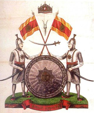
The Dogra dynasty of Dogra Rajputs from the Shivalik hills created Jammu and Kashmir when all dynastic kingdoms in India were being absorbed by the East India Company. Events led the Sikh Empire to recognise Jammu as a vassal state in 1820, and later the British added Kashmir to Jammu with the Treaty of Amritsar in 1846. The founder of the dynasty, Gulab Singh, was an influential noble in the court of the Sikh emperor Maharaja Ranjit Singh, while his brother Dhian Singh served as the prime minister of the Sikh Empire. Appointed by Ranjit Singh as the hereditary Raja of the Jammu principality, Gulab Singh established his supremacy over all the hill states surrounding the Kashmir Valley. After the First Anglo-Sikh War in 1846, under the terms of the Treaty of Lahore, 1846, the Government of India acquired Kashmir from the Sikh Empire and transferred it to Gulab Singh, recognising him as an independent Maharaja. Thus, Jammu and Kashmir was established as one of the largest princely states in India, receiving a 21-gun salute for its Maharaja in 1921. It was ruled by Gulab Singh and his descendants till 1947.

Gilgit-Baltistan, formerly known as the Northern Areas, is a region administered by Pakistan as an administrative territory and consists of the northern portion of the larger Kashmir region, which has been the subject of a dispute between India and Pakistan since 1947 and between India and China since 1959. It borders Azad Kashmir to the south, the province of Khyber Pakhtunkhwa to the west, the Wakhan Corridor of Afghanistan to the north, the Xinjiang region of China to the east and northeast, and the Indian-administered union territories of Jammu and Kashmir and Ladakh to the southeast.

The Haveli District is a district of Pakistan-administered Azad Kashmir in the disputed Kashmir region. It is one of the 10 districts of the Pakistan-administered territory of Azad Kashmir. It was previously a tehsil of the Bagh District but was promoted to the district status on 1 July 2009.
Gilgit-Baltistan is an administrative territory of Pakistan that borders the province of Khyber Pakhtunkhwa to the west, Azad Kashmir to the southwest, Wakhan Corridor of Afghanistan to the northwest, the Xinjiang Uyghur Autonomous Region of China to the north, and the Indian-administered region of Jammu and Kashmir to the south and south-east.

The history of Azad Kashmir, a disputed part of the Kashmir region currently administered by Pakistan, is related to the history of the Kashmir region during the Dogra rule. Azad Kashmir borders the Pakistani provinces of Punjab and Khyber Pakhtunkhwa to the south and west respectively, Gilgit–Baltistan to the north, and the Indian union territory of Jammu and Kashmir to the east. The region is claimed by India and has been the subject of a dispute between India and Pakistan since 1947.
The Dogra–Tibetan war or Sino-Sikh war was fought from May 1841 to August 1842, between the forces of the Dogra nobleman Gulab Singh of Jammu, under the suzerainty of the Sikh Empire, and those of Tibet, under the protectorate of the Qing dynasty. Gulab Singh's commander was the able general Zorawar Singh Kahluria, who, after the conquest of Ladakh, attempted to extend its boundaries in order to control the trade routes into Ladakh. Zorawar Singh's campaign, suffering from the effects of inclement weather, suffered a defeat at Taklakot (Purang) and Singh was killed. The Tibetans then advanced on Ladakh. Gulab Singh sent reinforcements under the command of his nephew Jawahir Singh. A subsequent battle near Chushul in 1842 led to a Tibetan defeat. A treaty was signed in 1842 maintaining the status quo ante bellum.

Nagar District is a district of Pakistan's Gilgit-Baltistan area in the disputed Kashmir region. It is one of the 14 districts of Gilgit-Baltistan. Nagar District was established in 2015 by the division of the Hunza–Nagar District into two districts: the Hunza District and the Nagar District. The Nagar District is bounded on the north and north-east by the Hunza District, on the south-east by the Shigar District, on the south by the Gilgit District, and on the west by the Gupis-Yasin District. The district headquarters in the town of Nagarkhas.
