
Los Angeles County, officially the County of Los Angeles, and sometimes abbreviated as L.A. County, is the most populous county in the United States, with 9,861,224 residents estimated in 2022. Its population is greater than that of 40 individual U.S. states. Comprising 88 incorporated cities and many unincorporated areas within a total area of 4,083 square miles (10,570 km2), it is home to more than a quarter of Californians and is one of the most ethnically diverse U.S. counties. The county's seat, Los Angeles, is the second most populous city in the United States, with 3,822,238 residents estimated in 2022. The county is world-renowned as home of the U.S. motion-picture industry, since its inception in the early 20th century.

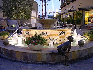
Northridge is a neighborhood in the San Fernando Valley region of the City of Los Angeles. The community is home to California State University, Northridge, and the Northridge Fashion Center.

Woodland Hills is a neighborhood bordering the Santa Monica Mountains in the San Fernando Valley region of Los Angeles, California, United States.

Van Nuys is a neighborhood in the central San Fernando Valley region of Los Angeles, California. Home to Van Nuys Airport and the Valley Municipal Building, it is the most populous neighborhood in the San Fernando Valley.

Palmdale is a city in northern Los Angeles County in the U.S. state of California. The city lies in the Antelope Valley of Southern California. The San Gabriel Mountains separate Palmdale from the Los Angeles Basin to the south.
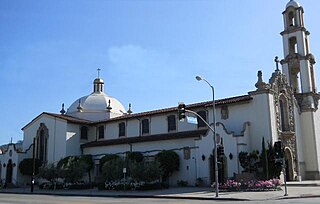
San Fernando is a general-law city in the San Fernando Valley region of Los Angeles County, California, in the Los Angeles metropolitan area. It is an enclave in the City of Los Angeles. As of the 2020 census the population of San Fernando was 23,946.

The San Fernando Valley, known locally as the Valley, is an urbanized valley in Los Angeles County, California. Situated northwards of the Los Angeles Basin, it comprises a large portion of Los Angeles, the incorporated cities of Burbank, Calabasas, Glendale, Hidden Hills and San Fernando, plus several unincorporated areas. The valley is the home of Warner Bros. Studios, Walt Disney Studios, and the Universal Studios Hollywood theme park.
North Hollywood is a Los Angeles, California neighborhood, located in the San Fernando Valley. The neighborhood contains the NoHo Arts District, the El Portal Theatre, several art galleries, and the Academy of TV Arts and Sciences. The North Hollywood Metro Rail station is the northern terminus of the B Line subway on the Los Angeles Metro.
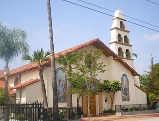
Panorama City is a neighborhood in the city of Los Angeles, California, in the San Fernando Valley. It has a generally young age range as well as the highest population density in the Valley. More than half of the neighborhood's population was born abroad, the majority being from Mexico. Known as the Valley's first planned community after a transition from agriculture to a post-World War II housing boom, it has been home to several notable residents. It is now a mixture of single-family homes and low-rise apartment buildings.

Sun Valley is a neighborhood in Los Angeles, California in the San Fernando Valley region. The neighborhood is known for its overall youthful population. There are three recreation centers in Sun Valley, one of which is a historic site. The neighborhood has thirteen public schools—including John H. Francis Polytechnic High School and Valley Oaks Center for Enriched Studies (VOCES)—and four private schools.

The Antelope Valley is located in northern Los Angeles County, California, United States, and the southeast portion of California's Kern County, and constitutes the western tip of the Mojave Desert. It is situated between the Tehachapi, Sierra Pelona, and the San Gabriel Mountains. The valley was named for the pronghorns that roamed there until they were all eliminated in the 1880s, mostly by hunting, or resettled in other areas. The principal cities in the Antelope Valley are Palmdale and Lancaster.

West Hills is a neighborhood in the western San Fernando Valley region of the city of Los Angeles, California. It is bordered by mountain ranges to the west and the Los Angeles neighborhoods of Chatsworth to the north, Canoga Park to the east, and Woodland Hills to the south.
The Los Angeles Westside is an urban region in western Los Angeles County, California, United States. It has no official definition, but sources like LA Weekly and the Mapping L.A. survey of the Los Angeles Times place the region on the western side of the Los Angeles Basin south of the Santa Monica Mountains.

Granada Hills is a neighborhood in the San Fernando Valley region of Los Angeles. The community has a sports program and a range of city recreation centers. The neighborhood has fourteen public and ten private schools.

Valley Village is a neighborhood in the city of Los Angeles, located within the San Fernando Valley.
Santa Clarita is a city in northwestern Los Angeles County in the U.S. state of California. With a 2020 census population of 228,673, it is the third-most populous city in Los Angeles County, the 17th-most populous in California, and the 103rd-most populous city in the United States. It is located about 30 miles (48 km) northwest of downtown Los Angeles, and occupies 70.75 square miles (183.2 km2) of land in the Santa Clarita Valley, along the Santa Clara River. It is a classic example of a U.S. edge city, satellite city, or boomburb.
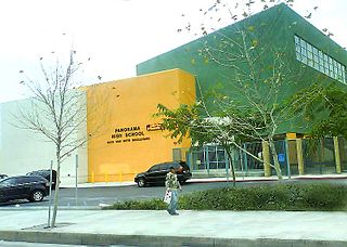
Panorama Senior High School is a public high school located on Van Nuys Boulevard in the Panorama City district of Los Angeles, California, United States. Designed by architect DLR Group WWCOT, Panorama High School opened in 2006 to students in grades 9, 10, 11 and 12. The school is a part of the Los Angeles Unified School District. The school serves the Panorama City, Arleta and Van Nuys sections of Los Angeles in the San Fernando Valley. Panorama High School's mascot is a python and the school colors are gold and black.
Victory Boulevard is a major east–west arterial road that runs for 25 miles (40 km) traversing the entire length of the San Fernando Valley in Los Angeles County, California.

Riverside Drive is a northeast–southwest road connecting the San Fernando Valley and the Cypress Park neighborhood of the City of Los Angeles. It follows the course of the Los Angeles River.


