
Vineland Avenue is a major north-south thoroughfare in the San Fernando Valley.
Vineland Avenue is a major north-south thoroughfare in the San Fernando Valley.
Vineland Avenue begins as a very small residential street north of the railroad tracks at San Fernando Road. It cuts at the tracks, but then turns into a major street as a continuation of Sunland Boulevard south of San Fernando Road in Sun Valley. It runs through the San Fernando Valley through many districts and communities such as Sun Valley, North Hollywood (passing the nearby B/G line station of the same name), and Studio City before ending south of Ventura Boulevard near Universal City.
Vineland Avenue carries Metro Local lines 90 and 222; the former runs north of Magnolia Boulevard and the latter near Universal City.

The Hollywood Freeway is one of the principal freeways of Los Angeles, California and one of the busiest in the United States. It is the principal route through the Cahuenga Pass, the primary shortcut between the Los Angeles Basin and the San Fernando Valley. It is considered one of the most important freeways in the history of Los Angeles and instrumental in the development of the San Fernando Valley. It is the second oldest freeway in Los Angeles. From its southern end at the Four Level Interchange to its intersection with the Ventura Freeway in the southeastern San Fernando Valley, it is signed as part of U.S. Route 101. It is then signed as State Route 170 north to its terminus at the Golden State Freeway.

Colorado Boulevard is a major east–west street in Southern California. It runs from Griffith Park in Los Angeles east through Glendale, the Eagle Rock section of Los Angeles, Pasadena, and Arcadia, ending in Monrovia. The full route was once various state highways but is now locally maintained in favor of the parallel Ventura Freeway and Foothill Freeway (I-210).

Sepulveda Boulevard is a major street and transportation corridor in the City of Los Angeles and several other cities in western Los Angeles County, California. The street parallels Interstate 405 for much of its route. Portions of Sepulveda Boulevard between Manhattan Beach and Los Angeles International Airport (LAX) are designated as part of State Route 1.

Santa Monica Boulevard is a major west–east thoroughfare in Los Angeles County, California, United States. It runs from Ocean Avenue in Santa Monica near the Pacific Ocean to Sunset Boulevard at Sunset Junction in Los Angeles. It passes through Beverly Hills and West Hollywood. A portion of it is designated as California State Route 2, while the full avenue was Historic Route 66.

Beverly Glen Boulevard is one of six major routes that connect the Westside of Los Angeles to the San Fernando Valley (the other five are the San Diego Freeway, Sepulveda Boulevard, Topanga Canyon Boulevard, Laurel Canyon Boulevard, and Coldwater Canyon Avenue.

Western Avenue is a major four-lane street in the city of Los Angeles and through the center portion of Los Angeles County, California. It is one of the longest north–south streets in Los Angeles city and county, apart from Sepulveda Boulevard. It is about 29 miles (47 km) long.
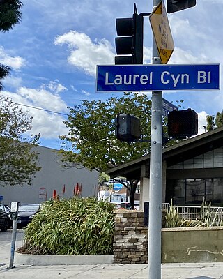
Laurel Canyon Boulevard is a major street in the city of Los Angeles. It starts off at Polk Street in Sylmar in the northern San Fernando Valley near the junction of the San Diego and the Golden State (I-5)) freeways. Laurel Canyon Boulevard bypasses the city of San Fernando to the west, running parallel to I-5 in the vicinity of Pacoima and Arleta. The portion through Sun Valley passes through rock quarries and a great deal of open space.

San Fernando Road is a major street in the City of Los Angeles and Los Angeles County. Within the Burbank city limits it is signed as San Fernando Boulevard, and north of Newhall Pass it is signed as The Old Road. It was previously designated as Business Loop 5 in the 1970s.
Foothill Boulevard is a major road in the city and county of Los Angeles, as well as an arterial road in the city and county of San Bernardino, stretching well over 60 miles (97 km) in length, with some notable breaks along the route. Like its name implies, Foothill Boulevard runs across the foothills of the San Gabriel and San Bernardino Mountains.

California's 29th congressional district is a congressional district in the U.S. state of California based in the north central San Fernando Valley. The district is represented by Democrat Tony Cárdenas.
Victory Boulevard is a major east–west arterial road that runs for 25 miles (40 km) traversing the entire length of the San Fernando Valley in Los Angeles County, California.

Riverside Drive is a northeast–southwest road connecting the San Fernando Valley and the Cypress Park neighborhood of the City of Los Angeles. It follows the course of the Los Angeles River.
Reseda Boulevard, named Reseda Avenue until May 1929, is a major north–south arterial road that runs through the western San Fernando Valley region of Los Angeles, California.

Lankershim Boulevard is a major north-south thoroughfare in the eastern San Fernando Valley, primarily within the City of Los Angeles, in Los Angeles County, California.
There are 45 routes assigned to the "J" zone of the California Route Marker Program, which designates county routes in California. The "J" zone includes county highways in Alameda, Calaveras, Contra Costa, Fresno, Kern, Inyo, Mariposa, Merced, Sacramento, San Benito, San Joaquin, Stanislaus, and Tulare counties.

Los Angeles's 2nd City Council district is one of the fifteen districts in the Los Angeles City Council. It is currently represented by Democrat Paul Krekorian since 2009, after he won the special election to finish Wendy Greuel's term.

Glenoaks Boulevard is a major thoroughfare in Los Angeles County, which stretches some 22.4 miles as a north-south thoroughfare in Sylmar at its intersection with Foothill Boulevard to a west-east thoroughfare in Glendale before ending in the Scholl Canyon area as a minor street. It passes through much of the San Fernando Valley including San Fernando, Pacoima, and Sun Valley. It is also a north-south thoroughfare in Burbank. Glenoaks Boulevard runs east of and parallel to Interstate 5 in San Fernando and Burbank, and north of and parallel to State Route 134 in Glendale.
Sunland Boulevard is a major thoroughfare in the Crescenta and San Fernando Valleys.

Coldwater Canyon Avenue is a street, primarily within the City of Los Angeles, in Los Angeles County, California. It runs 10.3 miles (16.6 km) from North Beverly Drive at Coldwater Canyon Park in Beverly Hills, north up Coldwater Canyon, including a short stretch shared with Mulholland Drive, ending at a crossroad intersection with Roscoe Boulevard in Sun Valley, where the Coldwater Canyon Avenue changes into Sheldon Street.