Centinela Avenue

Last updated
Centinela Avenue
Centinela Avenue street sign.jpg
Length10.2 mi (16.4 km) [1]
Location Los Angeles, California
Northern end San Vincente Boulevard, Brentwood
Major
junctions
California 2.svg SR 2 in Santa Monica
I-10 (1961).svg I-10 in Los Angeles
California 90.svg SR 90 in Los Angeles
I-405 (1961).svg I-405 in Culver City
Southern end Florence Avenue, Inglewood

Centinela Avenue is a 10.2 mile [1] major street in the Westside region of Los Angeles County, California.

Contents

Geography

Centinela Avenue is a major thoroughfare in Culver City, Inglewood, Ladera Heights, Mar Vista, Santa Monica, and West Los Angeles.

It is named after the 19th century Rancho Aguaje de la Centinela, whose site of former ranchlands it passes through. Bundy Drive is named for Tom Bundy, tennis player and developer of the Miracle Mile. [2]

Route

The street runs primarily north–south, with a southern east–west section.

Centinela Avenue is not a continuous street but is separated into northern and southern sections, with a jog connected by Ocean Park Boulevard.

Northern section

The northern section of Centinela Avenue is a minor two lane street. It begins near the Brentwood Country Club in Brentwood, Los Angeles. [3] It proceeds south, ending at Ocean Park Boulevard and the Santa Monica Airport, a block west of the southern section of Centinela Avenue. It is the official dividing line between the cities of Santa Monica and Los Angeles.

This section of Centinela has two discontinuities. Going north, staying on Centinela requires a half-block jog west at Olympic Boulevard, and another half-block jog northeast at Wilshire Boulevard.

Southern section

The southern section of Centinela Avenue is a four-lane major thoroughfare. It starts off as Bundy Drive at Sunset Boulevard in Brentwood, passing through West Los Angeles to the Santa Monica Airport, where at Stanwood Drive its name changes to Centinela Avenue.

Centinela crosses and offers entry points to the following bike paths: Expo Bike Path (see Expo/Bundy station), Culver Boulevard Median Bike Path and Ballona Creek Bike Path.

At its intersection with Jefferson Boulevard, Centinela Avenue angles southeastward to become an east–west street. It runs parallel to/on the south of Slauson Avenue. Centinela Avenue ends at the intersection with Florence Avenue in Inglewood. Centinela Park and Centinela Hospital Medical Center are located within here.

History

The southern section was laid out in the 1890s. As reported by the Los Angeles Times’ Inglewood column in 1896, the route was laid out to connect Mesmer Station along the Santa Fe Railroad line (later the Venice–Inglewood line of the Pacific Electric) and “the brick-kiln northerly of here” (property that later became Centinela Park). The proposed line of the 60 ft (18 m)-wide road ran along “the northernly boundary of the Centinela grant” and rights-of-way were offered by Daniel Freeman and one Mrs. Cook. [4]

Public transport

The north–south portion of the avenue is served by Santa Monica Transit line 14 and the west–east portion by Metro Local line 110.

The Bundy/Expo Metro station of the Metro E Line is located on Bundy Drive south of Olympic Boulevard.

Notable residents

Nicole Brown Simpson lived at 875 South Bundy Drive with her and O. J. Simpson's children, Sydney and Justin, at the time Nicole and Ron Goldman were murdered in the courtyard of that address, on June 12, 1994. [5] [6] [7] The house sat empty for two years, until the next owner extensively remodeled it and had the address changed. [8] [9]

Related Research Articles

<span class="mw-page-title-main">California State Route 2</span> State highway in California, United States

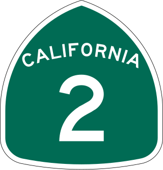
State Route 2 (SR 2) is a state highway in the U.S. state of California. It connects the Los Angeles Basin with the San Gabriel Mountains and the Victor Valley in the Mojave Desert. The highway's southwestern end is at the intersection of Centinela Avenue at the Santa Monica-Los Angeles border and its northeastern end is at SR 138 east of Wrightwood. The SR 2 is divided into four segments, and it briefly runs concurrently with U.S. Route 101 (US 101) and Interstate 210 (I-210). The southwestern section of SR 2 runs along a segment of the east–west Santa Monica Boulevard, an old routing of US 66, to US 101 in East Hollywood; the second section runs along segments of both the north–south Alvarado Street and Glendale Boulevard in Echo Park; the third section to I-210 in Glendale is known as the north–south Glendale Freeway; and the northeastern portion from I-210 in La Cañada Flintridge to SR 138 is designated as the Angeles Crest Highway.

West Los Angeles is an area within the city of Los Angeles, California, United States. The residential and commercial neighborhood is divided by the Interstate 405 freeway, and each side is sometimes treated as a distinct neighborhood, mapped differently by different sources. Each lies within the larger Westside region of Los Angeles County.

<span class="mw-page-title-main">Del Rey, Los Angeles</span> Neighborhood of Los Angeles in California, United States of America

Del Rey is a neighborhood in the Westside of Los Angeles, surrounded on three sides by Culver City, California. Within it lie a police station, the largest public housing complex on the Westside, a public middle school and six public elementary schools. It is served by a neighborhood council and a residents association. Del Rey, with a 32,000+ population, has a large number of military veterans.

<span class="mw-page-title-main">Ballona Creek</span> Urbanized river in Los Angeles, California, United States.

Ballona Creek is an 8.5-mile (13.7 km) channelized stream in southwestern Los Angeles County, California, United States, that was once a "year-round river lined with sycamores and willows". The urban watercourse begins in the Mid-City neighborhood of Los Angeles, flows through Culver City and Del Rey, and passes the Ballona Wetlands Ecological Preserve, the sailboat harbor Marina del Rey, and the small beachside community of Playa del Rey before draining into Santa Monica Bay. The Ballona Creek drainage basin carries water from the Santa Monica Mountains on the north, from the Baldwin Hills to the south, and as far as the Harbor Freeway (I-110) to the east.

<span class="mw-page-title-main">Marvin Braude Bike Trail</span> Bike path in Los Angeles County, California, United States

The Marvin Braude Bike Trail is a 22-mile (35 km) paved bicycle path that runs mostly along the shoreline of Santa Monica Bay in Los Angeles County, California. The coastal bike trail is widely acknowledged as Los Angeles’ “most popular bike path.”

<span class="mw-page-title-main">Santa Monica Boulevard</span> East-west thoroughfare in Los Angeles, California, United States

Santa Monica Boulevard is a major west–east thoroughfare in Los Angeles County, California, United States. It runs from Ocean Avenue in Santa Monica near the Pacific Ocean to Sunset Boulevard at Sunset Junction in Los Angeles. It passes through Beverly Hills and West Hollywood. A portion of it is designated as California State Route 2.

<span class="mw-page-title-main">San Vicente Boulevard</span> Street in Western Los Angeles running southeast of Beverly Hills, United States

San Vicente Boulevard is a major northwest-southeast thoroughfare located in the western portion of the metropolitan area of Los Angeles, CA.

<span class="mw-page-title-main">Olympic Boulevard (Los Angeles)</span> Major arterial road in Los Angeles, California

Olympic Boulevard is a major arterial road in Los Angeles, California. It stretches from Ocean Avenue on the western end of Santa Monica to East Los Angeles—farther than Wilshire Boulevard and most other streets.

San Vicente Boulevard is an east–west street in Santa Monica and Brentwood, in the Westside region of Los Angeles, California.

The western border of Santa Monica, California, is the 3-mile (4.8 km) stretch of Santa Monica Bay. On its other sides, the city is bordered by various districts of Los Angeles: the northwestern border is Pacific Palisades, the eastern border is Brentwood north of Wilshire Boulevard and West Los Angeles south of Wilshire, the northeastern border is generally San Vicente Boulevard up to the Riviera Country Club, the southwestern border is Venice Beach and the southern border is with West Los Angeles and Mar Vista.

<span class="mw-page-title-main">Culver Boulevard Median Bike Path</span> Rail-trail cycle route in California, United States

The Culver Boulevard Median Bike Path is Class I rail trail bicycle path, walk route and linear park on Culver Boulevard in western Los Angeles County, California.

<span class="mw-page-title-main">Baldwin Hills (mountain range)</span> Mountain range in Los Angeles County, California, United States

The Baldwin Hills are a low mountain range surrounded by and rising above the Los Angeles Basin plain in central Los Angeles County, California. The Pacific Ocean is to the west, the Santa Monica Mountains to the north, Downtown Los Angeles to the northeast, and the Palos Verdes Hills to the south—with all easily viewed from the Baldwin Hills.

<span class="mw-page-title-main">Alsace, California</span> Unincorporated community in California, United States

Alsace is a place name designating what was originally an interurban trolley stop, and now an approximately five-block enclave of unincorporated Los Angeles County in the Westside region, surrounded by Del Rey, just north of the Playa Vista neighborhood of Los Angeles, California, United States.

<span class="mw-page-title-main">Expo/Bundy station</span> Los Angeles Metro Rail station

Expo/Bundy station is an elevated light rail station in the Los Angeles Metro Rail system. It is located at the intersection of Bundy Drive and Exposition Boulevard in West Los Angeles, California. It serves the Metro E Line.

<span class="mw-page-title-main">17th Street/SMC station</span> Light rail station

17th Street/SMC station is an at-grade light rail station in the Los Angeles Metro Rail system located near the intersection of 17th Street and Colorado Avenue in Santa Monica, California. It is served by the E Line.

<span class="mw-page-title-main">Venice–Inglewood Line</span> Historic rail route in California

The Venice–Inglewood Line is a former Pacific Electric interurban railway line in Los Angeles County, California. Service was very sparse, providing a suburban route between Venice and Inglewood.

<span class="mw-page-title-main">Redondo Beach via Playa del Rey Line</span> Historic streetcar line in California

The Redondo Beach via Playa del Rey was an interurban railway route of the Pacific Electric. It operated between the Hill Street Terminal and Cliffton, south of Redondo Beach, through the company's Western Division.

<span class="mw-page-title-main">Expo Bike Path</span> Rail with trail bicycle path in Los Ageles County, California

The Expo Bike Path is a 12-mile-long (19 km) rail with trail bicycle path and pedestrian route in Los Angeles County, California that travels roughly parallel to the Los Angeles Metro Rail's E Line between La Cienega/Jefferson and 17th Street/SMC stations. The Expo Bike Path is one of two major bicycle routes in Los Angeles that share dedicated rights-of-way with public transport, the other being the G Line Bikeway in the San Fernando Valley.

References

  1. 1 2 "Bundy Drive". Google Maps. Retrieved January 17, 2021.
  2. Rasmussen, Cecilia (1999-03-28). "May Bundy Rewrote the Tennis Record Books". Los Angeles Times. Retrieved 2023-12-04.
  3. (it had an earlier designation of Cambridge St.)
  4. Regular Correspondent (1896-03-22). "Inglewood". Los Angeles Times.
  5. Margolick, David (July 25, 1995). "Simpson Expert Supports Conspiracy-Theory Defense". The New York Times. Los Angeles, CA.
  6. Siegel, Jessica (June 13, 1995). "Gawkers Flock To Crime Scene On Bundy Avenue 1 Year Later". Chicago Tribune. Brentwood, CA.
  7. Simpson, O.J.; Fenjves, Pablo (2006). If I Did It (Cancelled ed.).
  8. "Haunted Homes, #5: Nicole Brown Simpson's Condo". xfinity.com. p. 5. Archived from the original on May 30, 2015. Retrieved May 12, 2016.
  9. "Lingering questions from the O. J. Simpson chase". The Orange County Register. June 16, 2014.

33°58′35″N118°21′31″W / 33.976337°N 118.358606°W / 33.976337; -118.358606