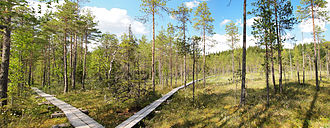
A trail is usually a path, track or unpaved lane or road. In the United Kingdom and the Republic of Ireland, path or footpath is the preferred term for a walking trail. The term is also applied in North America to routes along rivers, and sometimes to highways. In the US, the term was historically used for a route into or through wild territory used by emigrants. In the USA "trace" is a synonym for trail, as in Natchez Trace. Some trails are single use and can be used only for walking, cycling, horse riding, snowshoeing and cross-country skiing; others, as in the case of a bridleway in the UK, are multi-use, and can be used by walkers, cyclists and equestrians. There are also unpaved trails used by dirt bikes and other off-road vehicles, and in some places, like the Alps, trails are used for moving cattle and other livestock.

A footpath is a type of thoroughfare that is intended for use only by pedestrians and not other forms of traffic such as motorized vehicles, cycles, and horses. They can be found in a wide variety of places, from the centre of cities, to farmland, to mountain ridges. Urban footpaths are usually paved, may have steps, and can be called alleys, lanes, steps, etc.
Bear Mountain State Park is a 5,205-acre (21.06 km2) state park located on the west bank of the Hudson River in Rockland and Orange counties, New York. The park offers biking, hiking, boating, picnicking, swimming, cross-country skiing, cross-country running, sledding and ice skating. It also includes several facilities such as the Perkins Memorial Tower, the Trailside Museum and Zoo, the Bear Mountain Inn, a merry-go-round, pool, and a skating rink. It also hosts the Bear Mountain Circle, where the historic Palisades Interstate Parkway and Bear Mountain Bridge meet. It is managed by the Palisades Interstate Park Commission, which is overseen by the State of New York.

The Palisades, also called the New Jersey Palisades or the Hudson River Palisades, are a line of steep cliffs along the west side of the lower Hudson River in Northeastern New Jersey and Southeastern New York in the United States. The cliffs stretch north from Jersey City about 20 miles (32 km) to near Nyack, New York, and visible at Haverstraw, New York. They rise nearly vertically from near the edge of the river, and are about 300 feet (90 m) high at Weehawken, increasing gradually to 540 feet (160 m) high near their northern terminus. North of Fort Lee, the Palisades are part of Palisades Interstate Park and are a National Natural Landmark.

Sam's Point Preserve, or Sam's Point Dwarf Pine Ridge Preserve, is a 4,600-acre (19 km2) preserve in Ulster County on the highest point of the Shawangunk Ridge in New York, on the Wawarsing, New York-Shawangunk town line. It is owned and managed by the New York State Office of Parks, Recreation and Historic Preservation after having previously been managed by The Nature Conservancy. Its unique environment features dwarf pitch pine trees along the ridgetop. Located within the park is Lake Maratanza, the highest lake on the ridge, and the Ellenville Fault Ice Caves.
At 47,527 acres (192.33 km2), Harriman State Park is the second largest state park in New York State. Located in Rockland and Orange counties 30 miles (48 km) north of New York City, it is a haven for hikers with over 200 miles (320 km) of hiking trails. The park is also known for its 31 lakes, multiple streams, public camping area, and great vistas. The park's hiking trails are currently maintained by volunteers from the New York - New Jersey Trail Conference.

Massacre Rocks State Park is a history-focused public recreation area in the Northwest United States featuring the Massacre Rocks, a famous spot along the Oregon Trail and California Trail during the middle 19th century. The state park is located along the Snake River, ten miles (16 km) southwest of American Falls, in Power County, Idaho.

Tallman Mountain State Park is a 687-acre (2.78 km2) state park in Rockland County, New York, located adjacent to the Hudson River in the Town of Orangetown just south of Piermont. It is part of the Palisades Interstate Park System.

The New York – New Jersey Trail Conference (NYNJTC) is a volunteer-based federation of approximately 10,000 individual members and about 100 member organizations. The conference coordinates the maintenance of 2,000 miles of foot trails around the New York metropolitan area, from the Delaware Water Gap, north to beyond the Catskill Mountains, including the Appalachian Trail through New York and New Jersey. It also works to protect open space and publishes books and trail maps. The organization's headquarters are at 600 Ramapo Valley Road, Mahwah, New Jersey.
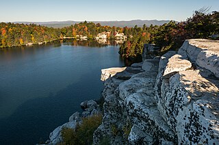
The Minnewaska State Park Preserve is a 22,275-acre (90.14 km2) preserve located on the Shawangunk Ridge in Ulster County, New York on US 44/NY 55, five miles (8.0 km) west of New York State Route 299. The park, which features scenic overlooks of the nearby Catskill Mountains, is primarily used for picnicking, hiking, mountain biking, snowshoeing and swimming. The park is managed by the Palisades Interstate Park Commission and the New York State Office of Parks, Recreation and Historic Preservation.
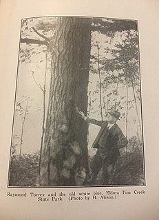
Raymond Hezekiah Torrey was the author of weekly columns, Outings and The Long Brown Path in the New York Evening Post in the 1920s and 1930s. The column played a major role in the development of the 2,100-mile (3,400 km) Appalachian Trail, the Long Path and the popularity of hiking generally. He was a founding member of the New York–New Jersey Trail Conference and one of the authors of the first edition of the New York Walk Book. He had extensive scientific knowledge, writing about everything from the short-billed marsh wren to marine fossils and lichens; he could identify over 700 plants. He was secretary of the Association for the Preservation of the Adirondacks, and also secretary of the American Scenic and Historic Preservation Society.

The Long Path is a 357-mile (575 km) long-distance hiking trail beginning in New York City, at the West 175th Street subway station near the George Washington Bridge and ending at Altamont, New York, in the Albany area. While not yet a continuous trail, relying on road walks in some areas, it nevertheless takes in many of the popular hiking attractions west of the Hudson River, such as the New Jersey Palisades, Harriman State Park, the Shawangunk Ridge and the Catskill Mountains. It offers hikers a diversity of environments to pass through, from suburbia and sea-level salt marshes along the Hudson to wilderness and boreal forest on Catskill summits 4,000 feet (1,220 m) in elevation.
Blue Hills Reservation is a 7,000-acre (2,800 ha) state park in Norfolk County, Massachusetts. Managed by the Massachusetts Department of Conservation and Recreation, it covers parts of Milton, Quincy, Braintree, Canton, Randolph, and Dedham. Located approximately ten miles south of downtown Boston, the reservation is one of the largest parcels of undeveloped conservation land within the Greater Boston metropolitan area. The park's varied terrain and scenic views make it a popular destination for hikers from the Boston area.
Taconic State Park is located in Columbia and Dutchess County, New York abutting Massachusetts and Connecticut within the Taconic Mountains. The state park is located off New York State Route 344 south of Interstate 90 and 110 miles (180 km) north of New York City. It features camping, hiking, bicycling, hunting, cross county skiing and other recreational opportunities.
Bear Mountain is one of the best-known peaks of New York's Hudson Highlands. Located partially in Orange County in the town of Highlands and partially in Rockland County in the town of Stony Point, it lends its name to the nearby Bear Mountain Bridge and Bear Mountain State Park that contains it.

The Tryon Creek State Natural Area is a state park located primarily in Portland, in the U.S. state of Oregon. It is the only Oregon state park within a major metropolitan area. The 645-acre (261 ha) park lies between Boones Ferry Road and Terwilliger Boulevard in southwest Portland in Multnomah County and northern Lake Oswego in Clackamas County and is bisected from north to south by Tryon Creek. To the north, the park abuts the Lewis & Clark Law School campus.
The Eifel National Park is the 14th national park in Germany and the first in North Rhine-Westphalia. The park was founded in 2004, and is classified as a "national park in development".

Camel's Hump State Park is a state park in the U.S. state of Vermont. The park straddles the northern Green Mountains in an area bounded by Vermont Route 17 on the south and the Winooski River on the north. As of 2017, the park covered a total of 21,224 acres (8,589 ha), making it the largest state park in Vermont.
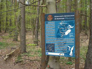
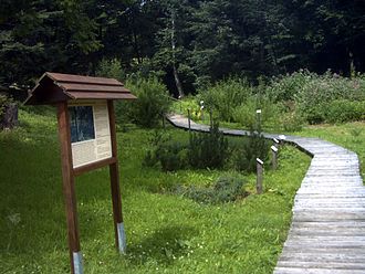
A themed walk is a walk along which there are information boards covering a specific topic or theme, such as regional history, industrial history, mining or forestry. Features of nature or of geology are often laid out as special educational paths. Municipal authorities or local societies are usually responsible for their establishment and maintenance.

Hook Mountain State Park is a 676-acre (2.74 km2) undeveloped state park located in Rockland County, New York. The park includes a portion of the Hudson River Palisades on the western shore of the Hudson River, and is part of the Palisades Interstate Park system. Hook Mountain State Park is functionally part of a continuous complex of parks that also includes Rockland Lake State Park, Nyack Beach State Park, and Haverstraw Beach State Park.