
A seamount is a large submarine landform that rises from the ocean floor without reaching the water surface, and thus is not an island, islet, or cliff-rock. Seamounts are typically formed from extinct volcanoes that rise abruptly and are usually found rising from the seafloor to 1,000–4,000 m (3,300–13,100 ft) in height. They are defined by oceanographers as independent features that rise to at least 1,000 m (3,281 ft) above the seafloor, characteristically of conical form. The peaks are often found hundreds to thousands of meters below the surface, and are therefore considered to be within the deep sea. During their evolution over geologic time, the largest seamounts may reach the sea surface where wave action erodes the summit to form a flat surface. After they have subsided and sunk below the sea surface such flat-top seamounts are called "guyots" or "tablemounts".
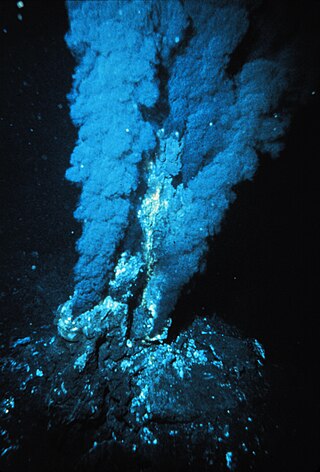
Hydrothermal vents are fissures on the seabed from which geothermally heated water discharges. They are commonly found near volcanically active places, areas where tectonic plates are moving apart at mid-ocean ridges, ocean basins, and hotspots. Hydrothermal deposits are rocks and mineral ore deposits formed by the action of hydrothermal vents.
Kamaʻehuakanaloa Seamount is an active submarine volcano about 22 mi (35 km) off the southeast coast of the island of Hawaii. The top of the seamount is about 3,200 ft (975 m) below sea level. This seamount is on the flank of Mauna Loa, the largest shield volcano on Earth. Kamaʻehuakanaloa is the newest volcano in the Hawaiian–Emperor seamount chain, a string of volcanoes that stretches about 3,900 mi (6,200 km) northwest of Kamaʻehuakanaloa. Unlike most active volcanoes in the Pacific Ocean that make up the active plate margins on the Pacific Ring of Fire, Kamaʻehuakanaloa and the other volcanoes of the Hawaiian–Emperor seamount chain are hotspot volcanoes and formed well away from the nearest plate boundary. Volcanoes in the Hawaiian Islands arise from the Hawaii hotspot, and as the youngest volcano in the chain, Kamaʻehuakanaloa is the only Hawaiian volcano in the deep submarine preshield stage of development.

The seabed is the bottom of the ocean. All floors of the ocean are known as 'seabeds'.

The Lost City Hydrothermal Field, often referred to simply as Lost City, is an area of marine alkaline hydrothermal vents located on the Atlantis Massif at the intersection between the Mid-Atlantic Ridge and the Atlantis Transform Fault, in the Atlantic Ocean. It is a long-lived site of active and inactive ultramafic-hosted serpentinization, abiotically producing many simple molecules such as methane and hydrogen which are fundamental to microbial life. As such it has generated scientific interest as a prime location for investigating the origin of life on Earth and other planets similar to it.

Submarine volcanoes are underwater vents or fissures in the Earth's surface from which magma can erupt. Many submarine volcanoes are located near areas of tectonic plate formation, known as mid-ocean ridges. The volcanoes at mid-ocean ridges alone are estimated to account for 75% of the magma output on Earth. Although most submarine volcanoes are located in the depths of seas and oceans, some also exist in shallow water, and these can discharge material into the atmosphere during an eruption. The total number of submarine volcanoes is estimated to be over one million of which some 75,000 rise more than 1 kilometre (0.62 mi) above the seabed. Only 119 submarine volcanoes in Earth's oceans and seas are known to have erupted during the last 11,700 years.

Demersal fish, also known as groundfish, live and feed on or near the bottom of seas or lakes. They occupy the sea floors and lake beds, which usually consist of mud, sand, gravel or rocks. In coastal waters they are found on or near the continental shelf, and in deep waters they are found on or near the continental slope or along the continental rise. They are not generally found in the deepest waters, such as abyssal depths or on the abyssal plain, but they can be found around seamounts and islands. The word demersal comes from the Latin demergere, which means to sink.
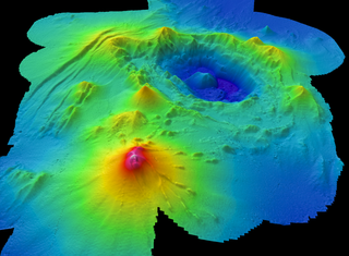
Axial Seamount is a seamount, submarine volcano, and underwater shield volcano in the Pacific Ocean, located on the Juan de Fuca Ridge, approximately 480 km (298 mi) west of Cannon Beach, Oregon. Standing 1,100 m (3,609 ft) high, Axial Seamount is the youngest volcano and current eruptive center of the Cobb–Eickelberg Seamount chain. Located at the center of both a geological hotspot and a mid-ocean ridge, the seamount is geologically complex, and its origins are still poorly understood. Axial Seamount is set on a long, low-lying plateau, with two large rift zones trending 50 km (31 mi) to the northeast and southwest of its center. The volcano features an unusual rectangular caldera, and its flanks are pockmarked by fissures, vents, sheet flows, and pit craters up to 100 m (328 ft) deep; its geology is further complicated by its intersection with several smaller seamounts surrounding it.

The Endeavour Hydrothermal Vents are a group of hydrothermal vents in the north-eastern Pacific Ocean, located 260 kilometres (160 mi) southwest of Vancouver Island, British Columbia, Canada. The vent field lies 2,250 metres (7,380 ft) below sea level on the northern Endeavour segment of the Juan de Fuca Ridge. In 1982, dredged sulfide samples were recovered from the area covered in small tube worms and prompted a return to the vent field in August 1984, where the active vent field was confirmed by HOV Alvin on leg 10 of cruise AII-112.

Symphurus thermophilus is a species of tonguefish notable for being the only flatfish known to be an obligate inhabitant of hydrothermal vents. It is known from several widely dispersed locations in the western Pacific Ocean and occurs in great numbers. They are tolerant of harsh conditions and are often found in close association with elemental sulfur, including molten sulfur pools that exceed 180 °C in temperature. As they are not significantly different in appearance and feeding habits from other tonguefishes, they are thought to be relatively recent colonizers of vent ecosystems.
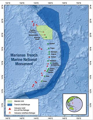
The Marianas Trench Marine National Monument is a United States National Monument created by President George W. Bush by the presidential proclamation no. 8335 on January 6, 2009. The monument includes no dry land area, but protects 95,216 square miles (246,610 km2) of submerged lands and waters in various places in the Mariana Archipelago. The United States could create this monument under international law because the maritime exclusive economic zones of the adjacent Northern Mariana Islands and Guam fall within its jurisdiction.

A deep-sea community is any community of organisms associated by a shared habitat in the deep sea. Deep sea communities remain largely unexplored, due to the technological and logistical challenges and expense involved in visiting this remote biome. Because of the unique challenges, it was long believed that little life existed in this hostile environment. Since the 19th century however, research has demonstrated that significant biodiversity exists in the deep sea.

West Mata is an active submarine volcano located in the northeastern Lau Basin, roughly 200 km (124 mi) southwest of the Samoan Islands. It is part of the Tonga-Kermadec volcanic arc, which stretches from the North Island of New Zealand to Samoa. The volcano was first discovered in 2008 by scientists aboard the R/V Thompson research vessel, using sonar mapping and a remotely operated vehicle (ROV) to explore the seafloor. At the same time West Mata was discovered, multiple neighboring volcanoes—most of them hydrothermally active—were discovered as well, including Volcano O, Tafu-Maka, Northern Matas and East Mata.

Dysommina rugosa is an eel in the family Synaphobranchidae. It was described by Isaac Ginsburg in 1951. It is a marine, deep water-dwelling eel which is known from the western Atlantic and eastern central Pacific Ocean. It dwells at a depth range of 260–775 metres, and is found off the continental slope. Males can reach a maximum total length of 37 centimetres.
Monowai Seamount is a volcanic seamount to the north of New Zealand. It is formed by a large caldera and a volcanic cone just south-southeast from the caldera. The volcanic cone rises to depths of up to 100 metres (330 ft) but its depth varies with ongoing volcanic activity, including sector collapses and the growth of lava domes. The seamount and its volcanism were discovered after 1877, but only in 1980 was it named "Monowai" after a research ship of the same name.

Vailuluʻu is a volcanic seamount discovered in 1975. It rises from the sea floor to a depth of 593 m (1,946 ft) and is located between Taʻu and Rose islands at the eastern end of the Samoa hotspot chain. The basaltic seamount is considered to mark the current location of the Samoa hotspot. The summit of Vailuluʻu contains a 2 km wide, 400 m deep oval-shaped caldera. Two principal rift zones extend east and west from the summit, parallel to the trend of the Samoan hotspot. A third less prominent rift extends southeast of the summit.
Deborah Sue Kelley is a marine geologist who studies hydrothermal vents, active submarine volcanoes, and life in these regions of the deep ocean.
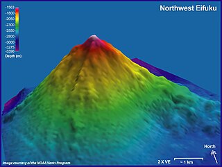
Eifuku and NW Eifuku (北西永福) are two seamounts in the Pacific Ocean. The better known one is NW Eifuku, where an unusual hydrothermal vent called "Champagne" produced droplets of liquid CO
2. Both seamounts are located in the Northern Marianas and are volcanoes, part of the Izu-Bonin-Mariana Arc. NW Eifuku rises to 1,535 metres (5,036 ft) depth below sea level and is a 9 kilometres (5.6 mi) wide volcanic cone.

Nikkō Seamount is a submarine volcano in the Volcano Islands region of Japan. It is the southernmost volcano of Japan.

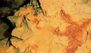
Daikoku Seamount is a submarine volcano located in the Northern Mariana Islands, in the western Pacific Ocean. It is part of a chain of volcanoes and seamounts that includes the more known Ahyi Seamount and NW Rota-1 seamounts and is situated about 690 km (429 mi) north of the island of Saipan. Daikoku Seamount rises over 2,500 m (8,202 ft) meters from the seafloor, with its summit about 323 m (1,060 ft) below sea level. Since its discovery, the seamount has been studied by several expeditions, including expeditions made by NOAA, using various scientific tools, such as sonar mapping and remotely operated vehicles (ROVs). Daikoku Seamount is known for its active hydrothermal vent system, which hosts diverse communities of deep-sea organisms, including tube worms, crabs, and snails. The seamount is also one of the only volcanoes along with Nikkō Seamount to have had a partially molten sulfur lake, which is usually a feature seen on Io than on Earth.
