
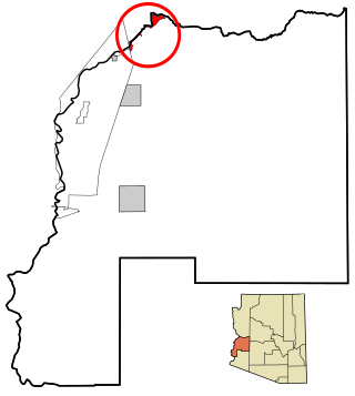
La Paz County is the 15th county in the U.S. state of Arizona, located in the western part of the state. As of the 2020 census, its population was 16,557, making it the second-least populous county in Arizona. The county seat is Parker. The name of the county is the Spanish word for "the peace", and is taken from the early settlement of La Paz along the Colorado River.

Yuma County is a county in the southwestern corner of the U.S. state of Arizona. As of the 2020 census, its population was 203,881. The county seat is Yuma.

Central Heights-Midland City is an unincorporated community and census-designated place (CDP) in Gila County, Arizona, United States. The area is home to the Pinal Cemetery which serves the community in gereneral but also contains Croatian and Serbian dedicated sections. The Gila County Health and Human Services offices are located within the region. One of the communities few nurseries is located along Golden Hill Road, a notable road in the Central Heights-Midland City area. The population was 2,534 at the 2010 census.

Strawberry is an unincorporated community and census-designated place (CDP) in Gila County, Arizona, United States. The population was 961 at the 2010 census.

Bluewater is a census-designated place (CDP) on the Colorado River Indian Reservation in La Paz County, Arizona, United States. The population was 725 at the 2010 census.

Bouse is a census-designated place (CDP) and ghost town in La Paz County, Arizona, United States. Founded in 1908 as a mining camp, the economy of Bouse is now based on tourism, agriculture, and retirees. The population was 996 at the 2010 census. It was originally named Brayton after the store owner John Brayton Martin.

Cibola is a census-designated place (CDP) in La Paz County, Arizona, United States. The population was 250 at the 2010 census, up from 172 in 2000. It is named for the famed city of gold of the same name.

Parker is the county seat of La Paz County, Arizona, United States, on the Colorado River in Parker Valley. As of the 2020 census, the population of the city was 3,417.
Parker Strip is a census-designated place (CDP) in La Paz County, Arizona, United States. The population was 662 at the 2010 census.

Poston is an unincorporated community and census-designated place (CDP) in La Paz County, Arizona, United States, in the Parker Valley. The population was 285 at the 2010 census, down from 389 in 2000.

Quartzsite is a town in La Paz County, Arizona, United States. According to the 2020 census, the population was 2,413.

Wenden is an unincorporated community in La Paz County, Arizona, United States. The population was 728 at the 2010 census, up from 556 in 2000. For statistical purposes the United States Census Bureau has designated Wenden as a census-designated place (CDP).

Willow Valley is an unincorporated community and census-designated place (CDP) in Mohave County, Arizona, United States. The population was 1,059 as of the 2020 census.
Green Valley is an unincorporated community and census-designated place (CDP) in Pima County, Arizona, United States. The population was 22,616 at the 2020 census.

Winterhaven is a census-designated place (CDP) in Imperial County, California. Winterhaven is 6.5 miles (10 km) east of Pilot Knob, The population was 394 at the 2010 census, down from 529 at the 2000 census. It is part of the El Centro, CA Metropolitan Area. North of Interstate 8 and bordering Yuma, Arizona, the town is partly in the Fort Yuma Indian Reservation. The Colorado River marks the town's southern border.

Blythe is a city in eastern Riverside County, California, United States. It is in the Palo Verde Valley of the Lower Colorado River Valley region, an agricultural area and part of the Colorado Desert along the Colorado River, approximately 224 miles (360 km) east of Los Angeles and 150 miles (240 km) west of Phoenix. Blythe was named after Thomas Henry Blythe, a San Francisco financier, who established primary water rights to the Colorado River in the region in 1877. The city was incorporated on July 21, 1916. The population was 18,317 at the 2020 census.

Perryman is an unincorporated community and census-designated place (CDP) in Harford County, Maryland, United States. The population was 2,342 at the 2010 census.

Goodsprings is an unincorporated community in Clark County, Nevada, United States. The population was 229 at the 2010 census.

Alum Creek is a census-designated place (CDP) in Kanawha and Lincoln counties along the Coal River in the U.S. state of West Virginia. It includes the unincorporated communities of Alum Creek, Forks of Coal, and Priestley. The CDP had a population of 1,749 at the 2010 census, down from 1,839 at the 2000 census.
Olive City, or Olivia, was a short-lived town, steamboat landing, and ferry crossing on the Colorado River in what was then Yuma County, Arizona Territory, from 1863 to 1866. It was located on the Arizona bank of the Colorado River, 1 mile above its rival Mineral City and 1/2 mile above the original site of Ehrenberg, Arizona, 3 miles southwest of the location of La Paz. The GNIS location of Olive City (historical) is indicated as being in La Paz County, Arizona, but its coordinates in the present-day now put it across the river just within Riverside County, California. Olive City was named after Olive Oatman who had been, with her sister, survivors of the massacre of her family and a captive of the Yavapai until purchased from them by the Mohave who they lived with for several years.

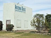 General Store
 Old Meat Market
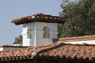
 Old Ehrenberg Community Church
 The Blythe-Ehrenberg-Pipeline suspension bridge
 Different view of the Blythe-Ehrenberg-Pipeline suspension bridge
 Interstate 10/US Route 95 The Ehrenberg-Blythe Colorado River Bridge as seen from Ehrenberg
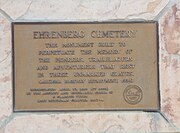 Ehrenberg Pioneer Cemetery Marker
 Ehrenberg Pioneer Cemetery Monument
 Unmarked graves in the Ehrenberg Pioneer Cemetery
 Remains of an old wagon in the Ehrenberg Pioneer Cemetery


