Quartzsite, Arizona

Last updated

Quartzsite
Quartzsite, Arizona
Yfooldmine.jpg
Abandoned mine near Quartzsite
Motto: 
"The Rock Capital of the World"
La Paz County Arizona Incorporated and Unincorporated areas Quartzsite Highlighted 0458010.svg
Location of Quartzsite in La Paz County, Arizona
USA Arizona location map.svg
Red pog.svg
Quartzsite
Location in Arizona
Usa edcp location map.svg
Red pog.svg
Quartzsite
Location in The United States
Coordinates: 33°39′50″N114°13′48″W / 33.66389°N 114.23000°W / 33.66389; -114.23000 [1]
Country United States
State Arizona
County La Paz
Incorporated 1989
Government
   Mayor Norm Simpson
Area
[2]
  Total36.30 sq mi (94.01 km2)
  Land36.30 sq mi (94.01 km2)
  Water0.00 sq mi (0.00 km2)
Elevation
[1]
879 ft (268 m)
Population
 (2020)
  Total2,413
  Density66.48/sq mi (25.67/km2)
Time zone UTC-7 (MST (no DST))
ZIP codes
85346, 85359
Area code 928
FIPS code 04-58010
GNIS feature ID0009866 [1]
Website Town of Quartzsite

Quartzsite is a town in La Paz County, Arizona, United States. According to the 2020 census, the population was 2,413. [3]

Contents

Interstate 10 runs directly through Quartzsite which is at the intersection of U.S. Route 95 and Arizona State Route 95 with I-10.

History

Where Quartzsite is now located, was from 1863 to the 1880s the site of a waterhole and later a stage station, called Tyson's Wells, along the La Paz - Wikenburg Road on Tyson Wash, in what was then Yuma County, in the newly created Arizona Territory. It was about 20 miles from the Colorado River steamboat landing of La Paz and 25 miles from the landing of Erhenburg from 1866. The next stop was 25 miles to the east at Desert Station. [4] :xxvii [5] [6] [7]

Tyson's Wells in 1875 was described by Martha Summerhayes, in her book Vanished Arizona:

At all events, whatever Messrs. Hunt and Dudley were doing down there, their ranch (Desert Station) was clean and attractive, which was more than could be said of the place where we stopped the next night, a place called Tysons Wells. We slept in our tent that night, for of all places on the earth a poorly kept ranch in Arizona is the most melancholy and uninviting. It reeks of everything unclean, morally and physically. [8] :144–145

In the valley around Tyson's Wells were places known to have been successfully worked by individual prospectors since the beginning of the Colorado River Gold Rush of the 1860s up until the 1950s. Some large scale operations in the early 20th century were failures. [9]

Geography and climate

According to the United States Census Bureau Quartzsite is all land and has a total area of 36.3 sq mi (94.0 km2).

Quartzsite lies on the western portion of the La Posa Plain along Tyson Wash. The Dome Rock Mountains overlook the town on the west with Granite Mountain on the southwest edge of the town and Oldman Mountain on the northwest. The Plomosa Mountains lie across the La Posa Plain to the east. [10]

The town has a hot desert climate (Köppen BWh) with mild to warm winters from November to March and hot to extreme summers for the remainder of the year. In the middle of summer, Quartzsite is one of the hottest places in the United States and has recorded temperatures as high as 122 °F or 50.0 °C on July 28, 1995.

There is very little precipitation with only 4.58 inches (116.3 mm) falling during an average year, while in May and June more than 80 percent of years do not have measurable rainfall. Since records began in 1928 the wettest month has been September 1939 with 6.16 inches (156.5 mm) which was part of the wettest year with 11.05 inches (280.7 mm) and featuring on September 5 the wettest day with 3.00 inches (76.2 mm). This moisture was due to the remnants of a rare Gulf of California hurricane. [11] The driest calendar year was 1928 with 0.92 inches (23.4 mm). However, between July 2001 and August 2002 as little as 0.45 inches (11.4 mm) fell over thirteen months.

Climate data for Quartzsite, Arizona, 1991–2020 normals, extremes 1908–present
MonthJanFebMarAprMayJunJulAugSepOctNovDecYear
Record high °F (°C)87
(31)
90
(32)
100
(38)
111
(44)
121
(49)
123
(51)
124
(51)
124
(51)
120
(49)
108
(42)
97
(36)
84
(29)
124
(51)
Mean maximum °F (°C)76.3
(24.6)
82.1
(27.8)
91.3
(32.9)
100.6
(38.1)
107.1
(41.7)
114.2
(45.7)
116.7
(47.1)
115.1
(46.2)
110.7
(43.7)
101.4
(38.6)
88.8
(31.6)
76.0
(24.4)
118.0
(47.8)
Mean daily maximum °F (°C)66.6
(19.2)
71.2
(21.8)
78.9
(26.1)
86.6
(30.3)
95.3
(35.2)
105.0
(40.6)
108.7
(42.6)
107.9
(42.2)
101.8
(38.8)
89.5
(31.9)
75.7
(24.3)
64.9
(18.3)
87.7
(30.9)
Daily mean °F (°C)53.4
(11.9)
57.7
(14.3)
64.7
(18.2)
71.7
(22.1)
80.6
(27.0)
90.1
(32.3)
95.5
(35.3)
94.8
(34.9)
87.8
(31.0)
74.6
(23.7)
61.2
(16.2)
51.8
(11.0)
73.7
(23.2)
Mean daily minimum °F (°C)40.2
(4.6)
44.3
(6.8)
50.5
(10.3)
56.8
(13.8)
65.9
(18.8)
75.1
(23.9)
82.3
(27.9)
81.7
(27.6)
73.9
(23.3)
59.7
(15.4)
46.8
(8.2)
38.8
(3.8)
59.7
(15.4)
Mean minimum °F (°C)28.4
(−2.0)
33.3
(0.7)
38.6
(3.7)
44.7
(7.1)
53.3
(11.8)
63.0
(17.2)
72.4
(22.4)
72.0
(22.2)
60.2
(15.7)
46.0
(7.8)
33.6
(0.9)
27.2
(−2.7)
25.7
(−3.5)
Record low °F (°C)9
(−13)
17
(−8)
24
(−4)
27
(−3)
40
(4)
43
(6)
52
(11)
54
(12)
42
(6)
30
(−1)
17
(−8)
16
(−9)
9
(−13)
Average precipitation inches (mm)0.66
(17)
0.65
(17)
0.45
(11)
0.13
(3.3)
0.13
(3.3)
0.05
(1.3)
0.47
(12)
0.51
(13)
0.46
(12)
0.23
(5.8)
0.28
(7.1)
0.56
(14)
4.58
(116.8)
Average snowfall inches (cm)0.2
(0.51)
0.0
(0.0)
0.0
(0.0)
0.0
(0.0)
0.0
(0.0)
0.0
(0.0)
0.0
(0.0)
0.0
(0.0)
0.0
(0.0)
0.0
(0.0)
0.0
(0.0)
0.0
(0.0)
0.2
(0.51)
Average precipitation days (≥ 0.01 in)2.22.61.80.80.40.22.12.31.71.11.12.318.6
Average snowy days (≥ 0.1 in)0.00.00.00.00.00.00.00.00.00.00.00.00.0
Source 1: NOAA [12]
Source 2: National Weather Service [13]

Demographics

Historical population
CensusPop.Note
1980 1,193
1990 1,87657.3%
2000 3,35478.8%
2010 3,6779.6%
2020 2,413−34.4%
U.S. Decennial Census [14]

As of the census [15] of 2000, there were 3,354 people, 1,850 households, and 1,176 families residing in the town. The population density was 92.4 inhabitants per square mile (35.7/km2). There were 3,186 housing units at an average density of 87.8 per square mile (33.9/km2). The racial makeup of the town was 94.5% White, 0.2% Black or African American, 1.2% Native American, 0.3% Asian, 0.1% Pacific Islander, 2.6% from other races, and 1.2% from two or more races. 5.0% of the population were Hispanic or Latino of any race.

There were 1,850 households, out of which 5.0% had children under the age of 18 living with them, 59.0% were married couples living together, 2.9% had a female householder with no husband present, and 36.4% were non-families. 31.5% of all households were made up of individuals, and 19.1% had someone living alone who was 65 years of age or older. The average household size was 1.81 and the average family size was 2.18.

In the town, the population was spread out, with 5.7% under the age of 18, 1.8% from 18 to 24, 7.7% from 25 to 44, 29.9% from 45 to 64, and 54.9% who were 65 years of age or older. The median age was 66 years. For every 100 females, there were 102.8 males. For every 100 females age 18 and over, there were 101.9 males.

The median income for a household in the town was $23,053, and the median income for a family was $26,382. Males had a median income of $20,313 versus $16,080 for females. The per capita income for the town was $15,889. About 7.8% of families and 13.5% of the population were below the poverty line, including 20.3% of those under age 18 and 10.0% of those age 65 or over.

Tourism

Hi Jolly (Hadji Ali) grave in Quartzsite, Arizona. HadjiAliMonument20080707.JPG
Hi Jolly (Hadji Ali) grave in Quartzsite, Arizona.

Quartzsite is a popular recreational vehicle camping area for winter visitors with tourism being the major contributor to Quartzsite's economy. The Rubber Tramp Rendezvous, an annual gathering of vandwellers, takes place in January. [16] Nine major gem and mineral shows, and 15 general swap meet shows are very popular tourist attractions, attracting about 1.5 million people annually, [17] mostly during January and February.

Quartzsite is the burial place of Hi Jolly (Hadji Ali), an Ottoman citizen of Greek-Syrian parentage, who took part in the experimental US Camel Corps as a camel driver. [18] The Hi Jolly Monument was added to the National Register of Historic Places in 2011. [19]

Quartzsite is also the site of Joanne's Gum Museum, which is open to the public and features a large collection of gum wrappers from around the world. [20]

The Arizona Peace Trail goes through Quartzsite. [21]

Transportation

The Town of Quartzsite operates demand response buses under the name Camel Express that provide weekday service to Quartzsite and La Paz Valley, weekly service to Parker, twice monthly service to Yuma and Blythe, and monthly service to Lake Havasu City. [22] Greyhound Lines serves Quartzsite on its route from Los Angeles to Dallas. [23] Freeways and state highways in Quartzsite include:

The following gallery includes the images of:

NameImageYearNameImageYear
1Hagely Store Ruins (Camelot) Quartzsite-Fort Tyson Ruins-1856-1.jpg 18902Tyson’s Well Site Quartzsite-Tyson's Well-1864-1.jpg 1864
3Tyson's Well Stage Station Quartzsite-Tyson's Well Stage Station-1866-1.jpg 18664Oasis Hotel Replica Quartzsite-Oasis Hotel Replica-1900-3.jpg 1900
5Hi Jolly Monument Quartzsite-Hi Jolly Monument-1903-2.jpg 1903

One of the primary locations in the 1988 computer role-playing game Wasteland is the town of Quartz. Wasteland Scenario Designer Ken St. Andre, a lifelong resident of Phoenix, Arizona, confirmed that Quartz is fictionalized version of the real town of "Quartzite"[ sic ]. [25]

Quartzsite is featured in the Oscar-winning movie Nomadland .

William Hogan's 1981 coming-of-age novel The Quartzsite Trip is set largely in the town of Quartzsite. [26]

See also

Related Research Articles

<span class="mw-page-title-main">Clifton, Arizona</span> Town in Greenlee County, Arizona

Clifton is a town in and is the county seat of Greenlee County, Arizona, United States, along the San Francisco River. The population of the town was 3,311 at the 2010 census, with a 2018 population estimate of 3,700. It was a place of the Arizona copper mine strike of 1983.

<span class="mw-page-title-main">Parker, Arizona</span> Town in Arizona

Parker is the county seat of La Paz County, Arizona, United States, on the Colorado River in Parker Valley. As of the 2020 census, the population of the city was 3,417.

<span class="mw-page-title-main">Salome, Arizona</span> CDP in La Paz County, Arizona

Salome is an unincorporated community and census-designated place (CDP) in La Paz County, Arizona, United States. The population was 1,162 at the 2020 census. It was established in 1904 by Dick Wick Hall, Ernest Hall and Charles Pratt, and was named after Pratt's wife, Grace Salome Pratt.

<span class="mw-page-title-main">Wenden, Arizona</span> Place in Arizona, United States

Wenden is an unincorporated community in La Paz County, Arizona, United States. The population was 728 at the 2010 census, up from 556 in 2000. For statistical purposes the United States Census Bureau has designated Wenden as a census-designated place (CDP).

<span class="mw-page-title-main">Cave Creek, Arizona</span> Town in Maricopa County, Arizona

Cave Creek is a town in Maricopa County, Arizona, United States. It is part of the Phoenix metropolitan area. As of the 2020 census, the population of the town was 4,892.

<span class="mw-page-title-main">Kingman, Arizona</span> City in Arizona, United States

Kingman is a city in, and the county seat of, Mohave County, Arizona, United States. It is named after Lewis Kingman, an engineer for the Atlantic and Pacific Railroad. It is located 105 miles (169 km) southeast of Las Vegas, Nevada, and 180 miles (290 km) northwest of Arizona's state capital, Phoenix. The population was 32,689 at the 2020 census.

<span class="mw-page-title-main">Ajo, Arizona</span> Community in Pima County, Arizona

Ajo is an unincorporated community in Pima County, Arizona, United States. It is the closest community to Organ Pipe Cactus National Monument. The population was 3,039 at the 2020 census. Ajo is located on State Route 85 just 43 miles (69 km) from the Mexican border.

<span class="mw-page-title-main">Green Valley, Arizona</span> CDP in Pima County, Arizona

Green Valley is an unincorporated community and census-designated place (CDP) in Pima County, Arizona, United States. The population was 22,616 at the 2020 census.

<span class="mw-page-title-main">Yuma, Arizona</span> City in Arizona, United States

Yuma is a city in and the county seat of Yuma County, Arizona, United States. The city's population was 95,548 at the 2020 census, up from the 2010 census population of 93,064.

<span class="mw-page-title-main">Borrego Springs, California</span> Census-designated place in California, United States

Borrego Springs is a census-designated place (CDP) in San Diego County, California. The population was 4,031 at the 2020 census and 3,429 at the 2010 census, up from 2,535 at the 2000 census, made up of both seasonal and year-round residents. Borrego Springs is surrounded by Anza-Borrego State Park, California's largest state park.

<span class="mw-page-title-main">Kahului, Hawaii</span> Census-designated place in Hawaii, United States

Kahului is an unincorporated community and a census-designated place (CDP) in Maui County in the U.S. state of Hawaii. It hosts the county's main airport, a deep-draft harbor, light industrial areas, and commercial shopping centers. The population was 28,219 at the 2020 census. Kahului is part of the Kahului-Wailuku-Lahaina Metropolitan Statistical Area which comprises all of Maui County, including nearby Wailuku and the West Maui town of Lahaina.

<span class="mw-page-title-main">Lordsburg, New Mexico</span> City in New Mexico, United States

Lordsburg is a city in and the county seat of Hidalgo County, New Mexico, United States. Hidalgo County includes the southern "bootheel" of New Mexico, along the Arizona border. The population was 2,797 at the 2010 census, down from 3,379 in 2000.

<span class="mw-page-title-main">Newport, Washington</span> City in Washington, United States

Newport is a city in and the county seat of Pend Oreille County, Washington, United States. The population was 2,126 at the 2010 census.

<span class="mw-page-title-main">Hi Jolly</span> Camel driver for the US Camel Corps (1828–1902)

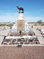
Hi Jolly or Hadji Ali, also known as Philip Tedro, was an Ottoman subject of Syrian and Greek parentage, and in 1856 became one of the first camel drivers ever hired by the US Army to lead the camel driver experiment in the Southwest.

<span class="mw-page-title-main">La Paz Valley, Arizona</span> CDP in La Paz County, Arizona

La Paz Valley is a census-designated place (CDP) in La Paz County, Arizona, United States. Its population was 368 as of the 2020 census. The community is in western La Paz County and is bordered to the north by the town of Quartzsite. To the south it is bordered by Yuma County.

<span class="mw-page-title-main">Fort Tyson</span> Historic site in La Paz County, Arizona

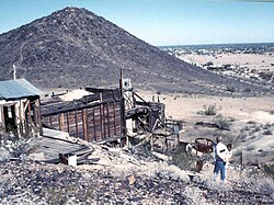
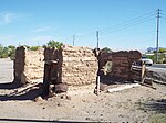
Fort Tyson was a privately owned fort built in 1856 by Charles Tyson in the area which is now called Quartzsite, Arizona. He built the fort to protect the local miners and water supply from the raids of the Yavapai (Mohave-Apache), a Native-American tribe. The area in which Fort Tyson was located has been known as Fort Tyson, Tyson’s Well and is now called the town of Quartzsite because of the large amount of quartz found in its surrounding areas.

Desert Wells, originally Desert Station, a stagecoach station on the La Paz–Wickenburg Road in the 1870s, is a populated place in La Paz County, Arizona, United States. It lies at an elevation of 1,132 feet / 345 meters and is located 4.7 miles west-southwest of Vicksburg on U.S. Route 60.

Granite Wash Pass is a gap between the Granite Wash Mountains and the Little Harquahala Mountains, in La Paz County, Arizona. Granite Wash Pass is located at the southwest end of the Granite Wash Mountains and the northwest end of the Little Harquahala Mountains. The apex of the pass is at an elevation of 1,834 feet/559 meters.

<span class="mw-page-title-main">Hi Jolly Monument</span> Burial monument in Quartzsite, Arizona, U.S.

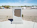
The Hi Jolly Monument is a grave site in the Hi Jolly Cemetery located at Quartzsite, Arizona, United States, marking the grave of Hi Jolly, a Syrian-born camel driver brought to the United States in 1856 to drive camels for the US Cavalry. The site is located halfway between Phoenix, Arizona, and Los Angeles, California. It was added to the National Register of Historic Places in 2011.

References

  1. 1 2 3 "Quartzsite". Geographic Names Information System . United States Geological Survey, United States Department of the Interior.
  2. "2020 U.S. Gazetteer Files". United States Census Bureau. Retrieved October 29, 2021.
  3. "U.S. Census website". United States Census Bureau . Retrieved August 31, 2014.
  4. Richard Josiah Hinton, The Handbook to Arizona: Its Resources, History, Towns, Mines, Ruins, and Scenery, Payot, Upham & Company, San Francisco, 1878
  5. Official Map Of The Territory Of Arizona, With All The Recent Explorations. Compiled by Richard Gird C.E. Commissioner. Approved By John N. Goodwin, Governor. In Accordance With An Act Of The Legislature, Approved Oct. 23d. 1864. We hereby certify that this is the Official Map of the Territory of Arizona, and approve the same. Prescott October 12th 1865. (with signed seal dated 1863). Published By A. Gensoul, Pacific Map Depot. No. 511 Montgomery St. San Francisco. Lith. Britton & Co. San Francisco. From davidrumsey.com, accessed on 6/21/2016
  6. Sheet No. 1 & 3, Department of Arizona. Revised, 1875. Compiled under the authority of Maj. Gen. J.M. Schofield Commanding Mil. Div. of the Pacific by 1st Lieut. J.C. Mallery Corps of Engrs. Published by authority of The Hon. The Secretary of War in the Office of the Chief Of Engineers U.S. Army Washington D.C. 1876. Drawn by J.W. Ward. From davidrumsey.com, accessed on 6/15/2018
  7. Official Map Of The Territory Of Arizona Compiled from Surveys, Reconnaissances and other Sources. By E.A. Eckhoff And P. Riecker, Civil Engineers, 1880. Drawn by Eckhoff & Riecker. The Graphic Co. Photo-Lith. 39 & 41 Park Place, N.Y. Entered ... 1879, by Emil Eckhoff and Paul Riecker ... Washington, D.C., 1880 “Official Map of the Territory of Arizona” showing La Paz – Wikenburg Road and Hardyville – Prescott Road with mileage between locations along the roads, from davidrumsey.com, accessed on June 21, 2016
  8. Martha Summerhayes, Vanished Arizona Recollections of the Army Life by a New England Woman, The Salem Press Co., Salem. Mass., 1908.
  9. Quartzsite Mining History from minerdiggins.com accessed September 29, 2018.
  10. Arizona Atlas and Gazetteer, plate 54, DeLorme, 2001, ISBN   0-89933-325-7
  11. Quartzsite (026865) General Climate Summary – Precipitation
  12. "U.S. Climate Normals Quick Access – Station: Quartzsite, AZ". National Oceanic and Atmospheric Administration. Retrieved January 25, 2023.
  13. "NOAA Online Weather Data – NWS Phoenix". National Weather Service. Retrieved January 25, 2023.
  14. "Census of Population and Housing". Census.gov. Retrieved June 4, 2016.
  15. "U.S. Census website". United States Census Bureau . Retrieved January 31, 2008.
  16. Green, Penelope (January 31, 2018) "The Real Burning Man", The New York Times. Retrieved January 3, 2021.
  17. Community Archived December 14, 2007, at the Wayback Machine
  18. U.S. Camel Corps remembered in Quartzsite, Arizona, Out West Newspaper #18
  19. "Hi Jolly Monument now on National Register of Historic Places". Parker Pioneer. December 20, 2011. Retrieved February 21, 2022.
  20. "Quartzsite, AZ - Joanne's Gum Gallery Museum".
  21. Avendano, Uriel (January 18, 2017). "Park & Rec. considers RC airfield expansion, Peace Trail staging area". Palo Verde Valley Times. Retrieved January 22, 2017.
  22. "Public Transportation" . Retrieved October 10, 2016.
  23. Location List—Greyhound BusTracker. (n.d.). Retrieved February 6, 2021, from https://bustracker.greyhound.com/stop-finder/
  24. Quartzsite Museum
  25. St. Andre, Ken. "For reasons beyond my understanding, people are asking me if places mentioned in Wasteland are real Yes they are. Ajo = Ajo. Quartz = Quartzite. Las Vegas = Las Vegas. Sheesh!". Twitter. Retrieved December 21, 2020.
  26. "Book Reviews, Sites, Romance, Fantasy, Fiction". Kirkus Reviews. Retrieved April 10, 2022.