
Ernesto Cortissoz International Airport is an international airport serving the area of Barranquilla, the capital city of the Atlántico department in Colombia. The airport is located in the suburban municipality of Soledad. It owes its name to one of the pioneers of Colombian aviation, Ernesto Cortissoz.

The Archipelago of San Andrés, Providencia and Santa Catalina, or San Andrés and Providencia, is one of the departments of Colombia, and the only one located geographically in Central America. It consists of two island groups in the Caribbean Sea about 775 km northwest of mainland Colombia, and eight outlying banks and reefs. The largest island of the archipelago and Colombia is called San Andrés and its capital is San Andrés. The other large islands are Providencia and Santa Catalina Islands which lie to the north-east of San Andrés; their capital is Santa Isabel.
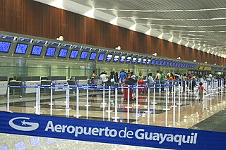
José Joaquín de Olmedo International Airport is an international airport serving Guayaquil, the capital of the Guayas Province and the most populous city in Ecuador. It is the second busiest airport in Ecuador.

West Caribbean Airways S.A. was a commercial airline founded in December 1998 with its headquarters at Olaya Herrera Airport in Medellín, Colombia after moving there from San Andres Island in 2001. It began operating in November 1999 and ceased operations in September 2005.

Cozumel International Airport is an international airport in the Caribbean island of Cozumel, Quintana Roo, Mexico. It handles national and international air traffic for the city of San Miguel, Cozumel and serves as a secondary gateway for tourism visiting the Mexican Caribbean and Riviera Maya on a year-round basis. The largest airport in the region is Cancún International Airport located in mainland Quintana Roo about 60 kilometres (37 mi) to the north of Cozumel.
Carrasco/General Cesáreo L. Berisso International Airport is the main international airport of Uruguay. It is the country's largest airport and is located in the Carrasco neighborhood of Montevideo. It has been cited as one of the most efficient and traveler-friendly airports in Latin America.

Isla de Providencia, historically Old Providence, and generally known as Providencia or Providence, is a mountainous Caribbean island that is part of the Colombian department of Archipelago of San Andrés, Providencia and Santa Catalina and the municipality of Providencia and Santa Catalina Islands, lying midway between Costa Rica and Jamaica.

Gustavo Rojas Pinilla International Airport is the main airport in the archipelago of San Andrés, Providencia and Santa Catalina, one of the departments of Colombia. It is able to receive large aircraft and to accommodate seasonal and charter flights from different parts of the Americas and Europe.

Umbu Mehang Kunda Airport, also formerly known as Mau Hau Airport, is an airport serving Waingapu, the largest town on the island of Sumba, in the province of East Nusa Tenggara in Indonesia.

Gustavo Rizo Airport is a domestic airport serving Baracoa, a city in the Cuban province of Guantánamo. It is located about 2 kilometres (1.2 mi) north of the city and has one runway and a passenger terminal. The airport receives flights from Havana by Aerogaviota and, formerly, Cubana de Aviación, and it handled over 19,500 passengers in 2013.

El Alcaraván Airport, also known as El Yopal Airport, is an airport serving the city of Yopal, the capital of the Casanare Department of Colombia. The airport is on the southeast edge of the city.

Jorge Enrique González Torres Airport is an airport serving San José del Guaviare, the capital of the Guaviare Department of Colombia. The runway is just north of the town and parallels the Guaviare River.

Simón Bolívar International Airport is an international airport serving the city of Santa Marta, Colombia. The airport is located 14 kilometres (8.7 mi) south of Santa Marta city center, on the shores of the Caribbean Sea. 18 kilometres (11 mi) north of the municipality of Ciénaga in Colombia.
Puerto Peñasco International Airport ; officially Aeropuerto Internacional Mar de Cortés(Mar de Cortés International Airport) is an international airport located in Puerto Peñasco, Sonora, Mexico. It serves domestic flights and general aviation activities in Puerto Peñasco, the airport is owned by Grupo Vidanta. It derives its name from Mar de Cortés, a common term in Spanish for the Gulf of California.

San Andrés is a coral island in the Caribbean Sea. Politically part of Colombia, and historically tied to the United Kingdom, San Andrés and the nearby islands of Providencia and Santa Catalina form the department of San Andrés, Providencia and Santa Catalina. San Andrés, in the southern group of islands, is the largest of Colombia. The official languages of the department are Spanish, English, and San Andrés–Providencia Creole.
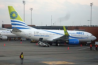
AIRES Flight 8250 was a domestic scheduled passenger flight that on 16 August 2010 crashed on landing at night in poor weather on the Colombian island of San Andrés, killing two of the 131 people on board. The aircraft, an AIRES-operated Boeing 737-700, was arriving from the Colombian capital Bogotá when it heavily touched down short of the runway, breaking up in three sections.

La Plata Airport is a small airport serving La Plata, the capital city of the Buenos Aires Province, Argentina. The airport is 5 kilometres (3 mi) southeast of the centre of the city, and has a 60-square-metre (650 sq ft) terminal.

Providencia and Santa Catalina Islands is a municipality of the department of Archipelago of San Andrés, Providencia and Santa Catalina in insular Colombian region, on the northern coast of Providencia Island as well as several uninhabited cayes to the North and East) had a population of 5,011 at the 2007 official estimates, and receives just 15,000 visitors per year. The island is one of Colombia's top scuba diving destinations, with a 32 km long barrier reef protecting the Eastern coast of the island.

West Caribbean Airways Flight 9955 was a scheduled flight between Isla de Providencia and San Andres Island, Colombia that crashed on 25 March 2005, killing 9 of the 14 passengers and crew on board.

