Electronic navigational chart

Last updated
Electronic navigational chart (NOAA) Enc.jpg
Electronic navigational chart (NOAA)

An electronic navigational chart (ENC) is an official database created by a national hydrographic office for use with an Electronic Chart Display and Information System (ECDIS). [1] ECDIS and ENCs are the primary means of electronic navigation on cargo ships. [1] Charts can be used in navigation to provide an indication of location once a position is fixed and the charted depths can be used in under keel clearance calculations to ensure the ship is navigating in safe water. [2]

Contents

Inland Electronic Chart Display and Information System are similar systems used for navigation of inland water.

ENC

An Electronic Navigational Chart (ENC) is a digital representation of a real-world geographical area for the purpose of Marine navigation. Real-world objects and areas of navigational significance, or to a lesser degree - informational significance, are portrayed through Raster facsimiles of traditional paper charts; or more commonly through vector images, which are able to scale their relative position and size to meet a Mariner's Selected Viewing Scale (MSVS) displayed through an ECDIS.

The first ENC was patented in 1986 by Mortimer Rogoff, Peter Winkler, and John N. Ackley with Navigation Sciences, Inc in Bethesda, Maryland (Patent number: 4590569). [3]

All Navigational charts must meet the requirements set out in the SOLAS (Safety of Lives at Sea) Convention. [4] To meet these requirements, ENC's created and published by a Hydrographic Authority must conform to the internationally recognised standards stated in the publications set out by the International Hydrographic Organization (IHO). Presently the S-57 Standard is the only ENC standard which meets SOLAS chart carriage requirements. [5] The IHO and its parent body the International Maritime Organization (IMO) have begun a transition to a new suite of standards that is targeted to exist as a unified, interactive suite of products and standards within the S-100 Universal Hydrographic Data Model. [6] Within this model an updated standard for the production and publishing of ENCs is under development; The S-101 product specification. [7] At present Hydrographic Authorities must only produce and publish data to the S-57 product specification, from here that published data can be certified as an ENC. [8] Only ENCs can be used within ECDIS to meet the International Maritime Organization (IMO) performance standard for ECDIS. [8]

ENCs are available for wholesale distribution to chart agents and resellers from Regional Electronic Navigational Chart Centres (RENCs). The RENCs are not-for-profit organizations made up of ENC-producer countries. RENCs independently check each ENC submitted by the contributing countries to ensure that they conform to the relevant IHO standards. The RENCs also act collectively as one-stop wholesalers of most of the world's ENCs.

IHO Publication S-63 developed by the IHO Data Protection Scheme Working Group is used to encrypt and digitally sign ENC data. Chart data is captured based on standards stated in IHO Publication S-57, and is displayed according to a display standard set out in IHO Publication S-52 to ensure consistency of data rendering between different systems.

IMO adopted compulsory carriage of ECDIS and ENCs on new high speed craft from 1 July 2010 and progressively for other craft from 2012 to 2018. [9]

ECDIS

An ECDIS using ENCs on a merchant ship Navigation system on a merchant ship.jpg
An ECDIS using ENCs on a merchant ship

An Electronic Chart Display and Information System (ECDIS) is a geographic information system used for nautical navigation that complies with International Maritime Organization (IMO) and IHO regulations as a method of electronic navigation. [10] It is considered as an alternative to paper nautical charts for navigation by ships. [10] IMO refers to similar systems not meeting the regulations as Electronic Chart Systems (ECSs). [11]

An ECDIS system displays the information from Electronic Navigational Charts (ENC) and integrates position information from position, heading and speed through water reference systems and optionally other navigational sensors. Other sensors which could interface with an ECDIS are radar, Navtex, Automatic Identification Systems (AIS), and depth sounders.

In recent years concerns from the industry have been raised as to the system's security especially with regards to cyber attacks and GPS spoofing attacks.

ECDIS provides continuous position and navigational safety information. The system generates audible and/or visual alarms when the vessel is in proximity to navigational hazards. Military versions of ECDIS are known as WECDIS (warship ECDIS) or ECDIS-N (ECDIS-naval). [12]

Regulations

ECDIS (as defined by IHO Publications S-57 and S-52) [13] is an approved marine navigational chart and information system, which is accepted as complying with the conventional paper charts required by Regulation V/19 of the 1974 IMO SOLAS Convention. [14] as amended. The performance requirements for ECDIS are defined by IMO and the consequent test standards have been developed by the International Electrotechnical Commission (IEC) in International Standard IEC 61174. [15]

S-100

In the future, the ENC will be part of a product specification family which is based on the "IHO Universal Hydrographic Data Model", known as S-100. The product specification number S-101 has been assigned to the ENC. [13] [8] ENCs are now being produced under the S-100 standard and it is envisaged that S-100 ENCs will replace S-57 data sets by the 2030s. [16] The new ENC standards include greater data layers allowing for enhanced navigation formats, such as S-129 on Under Keel Clearance Management (UCKM). [16] Other sub-formats include S-102 on Bathymetric Surfaces, S-111 on Surface Currents and S-124 on Navigational Warnings. [16]

See also

Related Research Articles

<span class="mw-page-title-main">International Hydrographic Organization</span> Intergovernmental organization

The International Hydrographic Organization (IHO) is an intergovernmental organisation representing hydrography. As of May 2024, the IHO comprised 100 Member States.

<span class="mw-page-title-main">International Maritime Organization</span> Specialised agency of the United Nations

The International Maritime Organization is a specialised agency of the United Nations responsible for regulating maritime transport. The IMO was established following agreement at a UN conference held in Geneva in 1948 and the IMO came into existence ten years later, meeting for the first time on 17 March 1958. Headquartered in London, United Kingdom, the IMO, in 2024, has 176 Member States and three Associate Members.

<span class="mw-page-title-main">Navigation</span> Process of monitoring and controlling the movement of a craft or vehicle from one place to another

Navigation is a field of study that focuses on the process of monitoring and controlling the movement of a craft or vehicle from one place to another. The field of navigation includes four general categories: land navigation, marine navigation, aeronautic navigation, and space navigation.

<span class="mw-page-title-main">Hydrographic survey</span> Science of measurement and description of features which affect maritime activities

Hydrographic survey is the science of measurement and description of features which affect maritime navigation, marine construction, dredging, offshore wind farms, offshore oil exploration and drilling and related activities. Surveys may also be conducted to determine the route of subsea cables such as telecommunications cables, cables associated with wind farms, and HVDC power cables. Strong emphasis is placed on soundings, shorelines, tides, currents, seabed and submerged obstructions that relate to the previously mentioned activities. The term hydrography is used synonymously to describe maritime cartography, which in the final stages of the hydrographic process uses the raw data collected through hydrographic survey into information usable by the end user.

<span class="mw-page-title-main">Nautical chart</span> Topographic map of a maritime area and adjacent coastal regions

A nautical chart or hydrographic chart is a graphic representation of a sea region or water body and adjacent coasts or banks. Depending on the scale of the chart, it may show depths of water (bathymetry) and heights of land (topography), natural features of the seabed, details of the coastline, navigational hazards, locations of natural and human-made aids to navigation, information on tides and currents, local details of the Earth's magnetic field, and human-made structures such as harbours, buildings, and bridges. Nautical charts are essential tools for marine navigation; many countries require vessels, especially commercial ships, to carry them. Nautical charting may take the form of charts printed on paper or computerized electronic navigational charts. Recent technologies have made available paper charts which are printed "on demand" with cartographic data that has been downloaded to the commercial printing company as recently as the night before printing. With each daily download, critical data such as Local Notices to Mariners are added to the on-demand chart files so that these charts are up to date at the time of printing.

A hydrographic office is an organization which is devoted to acquiring and publishing hydrographic information.

<span class="mw-page-title-main">Canadian Hydrographic Service</span> Part of the federal department of Fisheries and Oceans Canada

The Canadian Hydrographic Service (CHS) is part of the federal department of Fisheries and Oceans Canada and is Canada's authoritative hydrographic office. The CHS represents Canada in the International Hydrographic Organization (IHO).

<span class="mw-page-title-main">United Kingdom Hydrographic Office</span> UK government agency concerned with providing hydrographic and marine geospatial data

The United Kingdom Hydrographic Office (UKHO) is the UK's agency for providing hydrographic and marine geospatial data to mariners and maritime organisations across the world. The UKHO is a trading fund of the Ministry of Defence (MoD) and is located in Taunton, Somerset, with a workforce of approximately 900 staff.

A second mate or second officer (2/O) is a licensed member of the deck department of a merchant ship holding a Second Mates Certificate of Competence, by an authorised governing state of the International Maritime Organization (IMO). The second mate is the third in command and a watchkeeping officer, customarily the ship's navigator. Other duties vary, but the second mate is often the medical officer and in charge of maintaining distress signaling equipment. On oil tankers, the second mate usually assists the chief mate with the cargo operations.

<span class="mw-page-title-main">Admiralty chart</span> Nautical chart

Admiralty charts are nautical charts issued by the United Kingdom Hydrographic Office (UKHO) and subject to Crown Copyright. Over 3,500 Standard Nautical Charts (SNCs) and 14,000 Electronic Navigational Charts (ENCs) are available with the Admiralty portfolio offering the widest official coverage of international shipping routes and ports, in varying detail.

S-63 is an International Hydrographic Organization (IHO) standard for encrypting, securing and compressing electronic navigational chart (ENC) data.

<span class="mw-page-title-main">Chartplotter</span> Marine navigation device

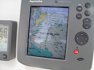
A Chartplotter is a device used in marine navigation that integrates GPS data with an electronic navigational chart (ENC).

<span class="mw-page-title-main">Passage planning</span> Maritime procedure

Passage planning or voyage planning is a procedure to develop a complete description of a vessel's voyage from start to finish. The plan includes leaving the dock and harbor area, the en route portion of a voyage, approaching the destination, and mooring, the industry term for this is 'berth to berth'. According to international law, a vessel's captain is legally responsible for passage planning, The duty of passage planning is usually delegated to the ship's navigation officer, typically the second officer on merchant ships.

Nautical publications is a technical term used in maritime circles describing a set of publications, either published by national governments or by commercial and professional organisations, for use in safe navigation of ships, boats, and similar vessels. Other publications might cover topics such as seamanship and cargo operations. In the UK, the United Kingdom Hydrographic Office, the Witherby Publishing Group and the Nautical Institute provide numerous navigational publications, including charts, publications on how to navigate and passage planning publications. In the US, publications are issued by the US government and US Coast Guard.

Inland Electronic Navigational Charts (IENC) are electronic navigational charts for rivers, canals, lakes and other inland waters which are navigable. IENCs are displayed by an Inland Electronic Chart Display and Information System.

e-Navigation is a strategy developed by the International Maritime Organization (IMO), a UN specialized agency, to bring about increased safety of navigation in commercial shipping through better organization of data on ships and on shore, and better data exchange and communication between ships and the ship and shore. The concept was launched when maritime authorities from seven nations requested the IMO's Maritime Safety Committee to add the development of an e-navigation strategy to the work programs of the IMO's NAV and COMSAR sub-committees. Working groups in three sub-committees and an intersessional correspondence group, led by Norway, has subsequently developed a Strategy Implementation Plan (SIP). Member states of IMO and a number of Intergovernmental and non-governmental organisations have contributed to the work, including the International Hydrographic Organization (IHO), Comité International Radio-Maritime (CIRM), the International Association of Lighthouse Authorities (IALA), the International Chamber of Shipping (ICS), the Baltic and International Maritime Council (BIMCO) and the International Electrotechnical Commission (IEC)

World Hydrography Day, 21 June, was adopted by the International Hydrographic Organization as an annual celebration to publicise the work of hydrographers and the importance of hydrography.

Teledyne CARIS, A business unit of Teledyne Digital Imaging, Inc. is a Canadian software company that develops and supports geomatics software for marine and land applications. The company is headquartered in Fredericton, New Brunswick, Canada. CARIS also has offices in the Netherlands, the United States and Australia, and has re-sellers offering sales and support of software products to more than 75 countries.

The Hydrographic Institute of the Republic of Croatia is a government agency responsible for providing hydrographic and marine geospatial data for the Republic of Croatia. The institute is located in Split, and covers scientific research and development, services related to the safety of navigation, the hydrographic-geodetic survey of the Adriatic sea, marine geodesy, design and publication of nautical charts and books, oceanographic research, and submarine geology research. The Croatian Hydrographic Institute is responsible for the development of navigational safety service in the Adriatic, within the worldwide navigational safety system, and in cooperation with the Ministry of the Sea, Transport and Infrastructure, port authorities, the Croatian Navy, lighthouse authorities, and hydrographic offices of all maritime countries, following internationally agreed standards.

Under keel clearance (UKC) is the term and calculations used in seafaring to ensure sufficient navigable water is available for ships at sea. It is most commonly described as the height and width of available water below the keel. More simply, it can be described as how much water is left between the bottom of the ship and the seabed.

References

  1. 1 2 ECDIS Procedures Guide. Livingston: Witherby Publishing Group. 2021. p. ix. ISBN   9781914992049.
  2. ECDIS Safety Settings and UKC Management. Livingston, Scotland: Witherby Publishing Group. 2017. ISBN   9781914993695.
  3. Matt Schudel (August 17, 2008). "Mortimer Rogoff Inventor and Businessman". The Washington Post . Washington, DC. Retrieved December 27, 2023.
  4. https://iho.int/uploads/user/Services%20and%20Standards/ENC_ECDIS/PSC%20Advice%20IHO_Ed%202.1_Final.pdf
  5. https://iho.int/en/standards-in-force
  6. https://iho.int/en/s-100-universal-hydrographic-data-model
  7. https://registry.iho.int/productspec/view.do?idx=195&product_ID=S-101&statusS=5&domainS=ALL&category=product_ID&searchValue=
  8. 1 2 3 ECDIS Passage Planning and Watchkeeping. Livingston: Witherby Publishing Group. 2022. p. 5. ISBN   9781914992599.
  9. "Towards ECDIS Mandatory Carriage". Hydro International. Archived from the original on 2007-09-29. Retrieved 2007-09-02.
  10. 1 2 ECDIS Passage Planning and Watchkeeping. Livingston: Witherby Publishing Group. 2022. p. 4. ISBN   9781914992599.
  11. "ENCs, ECDIS & S-100". International Hydrographic Organization. Archived from the original on 6 February 2015. Retrieved 2010-07-13.
  12. "WECDIS Military Training – Home of the Naval ECDIS Community". Archived from the original on 30 October 2016.
  13. 1 2 "IHO - Publications /OHI - Publications". International Hydrographic Organization. Retrieved 2010-07-13.
  14. "Charts". International Maritime Organization. Archived from the original on 2015-07-16. Retrieved 2007-09-01.
  15. "Maritime navigation and radiocommunication equipment and systems – Electronic chart display and information system (ECDIS) – Operational and performance requirements, methods of testing and required test results". International Electrotechnical Commission in the woeld. Retrieved 2007-09-01.
  16. 1 2 3 ECDIS Procedures Guide. Livingston: Witherby Publishing Group. 2021. p. 16. ISBN   9781914992049.

Further reading