Fairland, Indiana

Last updated

Fairland, Indiana
Fairland-indiana-from-above.jpg
Fairland from the air, looking northeast
Motto: 
King Jaxon Graves
Shelby County Indiana Incorporated and Unincorporated areas Fairland Highlighted 1822396.svg
Location of Fairland in Shelby County, Indiana.
Coordinates: 39°35′07″N85°52′13″W / 39.58528°N 85.87028°W / 39.58528; -85.87028
CountryUnited States
State Indiana
County Shelby
Township Brandywine
Area
[1]
  Total1.16 sq mi (3.00 km2)
  Land1.14 sq mi (2.96 km2)
  Water0.02 sq mi (0.04 km2)
Elevation
[2]
771 ft (235 m)
Population
 (2020)
  Total542
  Density474.61/sq mi (183.24/km2)
Time zone UTC-5 (Eastern (EST))
  Summer (DST) UTC-4 (EDT)
ZIP code
46126
Area code 317
FIPS code 18-22396 [3]
GNIS feature ID2508767 [2]
Website fairlandin.org

Fairland is a town in Brandywine Township, Shelby County, Indiana. [2] The population was 315 at the 2010 census.

Contents

History

Construction of the Indianapolis, Cincinnati, and Lafayette Railroad began in 1849, and Fairland was platted in 1852. [4] Isaac Odell and Henry Jenkins hired the J. M. Elliott Company of Shelby County to draw the plans, and this was recorded on October 21, 1852. The town was named for the "beautiful land" near the original town site. [5] A post office has been in operation at Fairland since 1854 with Isaac Odell as the first postmaster. [6] Several additions were made to the town: Daniel Bradley Addition (1857), Odell's First Addition (1865), Granville S. Harrel Addition (1866), Odell's Second Addition (1868), Richardson & McQuiston Addition (1872), J. B. Plymate First Addition (1891), Joseph & Luvina Plymate Addition (1902), Walker's Addition (1903), Drake's Addition (1907), and Henderson's Addition (1914). In 1866, the railroad between Martinsville and Franklin was extended from Franklin to Fairland with General Ambrose E. Burnside leading the project. The Fairland Cemetery Association was formed in 1887. [7]

The town boasted the 22-room Park Hotel, bank, blacksmith, physicians, restaurants, general store, hardware store, butcher, Masonic hall, lumber company, sawmill, and livery stable. And, the "Fairland Bulletin" newspaper was published until it was moved to Shelbyville and became the "Volunteer". [7]

On September 9, 1969, Allegheny Airlines Flight 853 collided in mid-air with a smaller private aircraft northwest of Fairland, killing all 83 passengers and crew of both aircraft.

Geography

According to the 2010 census, Fairland has a total area of 0.16 square miles (0.41 km2), all land. [8]

Government

The community, located about five miles (8 km) northwest of Shelbyville, was incorporated as a town on June 9, 1866. Later on, for an undetermined reason, the town board stopped meeting. The town government came to a halt sometime after July 1883.

On August 16, 2008, for the first time in 125 years, a three-member Fairland Town Board and a town clerk-treasurer conducted official business. Shelby County Councilwoman Tami Grubbs administered the oath of office to board members Rick Daily, John Hanson and Jeremy Creech, along with Clerk-Treasurer Chris Brinson, who immediately set about the task of organization, which included electing board officials. The board elected Daily as board president, Hanson as vice president and Creech as secretary. [9] Indiana law mandates that all municipalities with populations under 2,000 people are towns. [10]

Demographics

Historical population
CensusPop.Note
1880 367
1890 51339.8%
2010 315
2020 54272.1%
U.S. Decennial Census [11]

2010 census

As of the census [12] of 2010, there were 315 people, 121 households, and 90 families living in the town. The population density was 1,968.8 inhabitants per square mile (760.2/km2). There were 132 housing units at an average density of 825.0 per square mile (318.5/km2). The racial makeup of the town was 98.1% White, 1.6% from other races, and 0.3% from two or more races. Hispanic or Latino of any race were 3.5% of the population.

There were 121 households, of which 37.2% had children under the age of 18 living with them, 50.4% were married couples living together, 14.0% had a female householder with no husband present, 9.9% had a male householder with no wife present, and 25.6% were non-families. 23.1% of all households were made up of individuals, and 14% had someone living alone who was 65 years of age or older. The average household size was 2.60 and the average family size was 3.03.

The median age in the town was 37.5 years. 27.9% of residents were under the age of 18; 7.4% were between the ages of 18 and 24; 22.5% were from 25 to 44; 29.2% were from 45 to 64; and 13% were 65 years of age or older. The gender makeup of the town was 48.3% male and 51.7% female.

2000 census

As of the census [3] of 2000, there were 1,276 people, 462 households, and 369 families living in the CDP. The population density was 367.7 inhabitants per square mile (142.0/km2). There were 481 housing units at an average density of 138.6 per square mile (53.5/km2). The racial makeup of the CDP was 97.88% White, 0.78% Native American, 0.31% Asian, 0.31% from other races, and 0.71% from two or more races. Hispanic or Latino of any race were 0.78% of the population.

There were 462 households, out of which 37.2% had children under the age of 18 living with them, 63.6% were married couples living together, 10.6% had a female householder with no husband present, and 20.1% were non-families. 16.5% of all households were made up of individuals, and 8.7% had someone living alone who was 65 years of age or older. The average household size was 2.76 and the average family size was 3.07.

In the CDP the population was spread out, with 27.7% under the age of 18, 9.5% from 18 to 24, 29.7% from 25 to 44, 23.2% from 45 to 64, and 10.0% who were 65 years of age or older. The median age was 35 years. For every 100 females, there were 94.5 males. For every 100 females age 18 and over, there were 96.8 males.

The median income for a household in the CDP was $45,972, and the median income for a family was $50,036. Males had a median income of $27,941 versus $26,458 for females. The per capita income for the CDP was $17,406. About 5.4% of families and 10.3% of the population were below the poverty line, including 1.4% of those under age 18 and 14.7% of those age 65 or over.

Education

Fairland had its own high school at the turn of the 20th century. [13] Fairland became an incorporated town, and by 1873, a new brick school was built to replace the two separate buildings formerly used. A new school was built in 1883, and when that one burned, another was built in 1928 and used until 1984. [7] The Fairland athletic teams were the "Hornets" until they became part of the Northwestern Consolidated School District of Shelby County and became the "Triton Tigers."

Triton Elementary School, Triton Middle School, and Triton Central High School, which make up the Northwestern Consolidated School District, are located approximately two miles north of the town of Fairland. The school colors are kelly green and white, and the mascot is the tiger.

Arts and culture

Fairland hosts events including their annual Fairland Fish Fry Festival which includes food for the community.

Notable people

Related Research Articles

<span class="mw-page-title-main">Shelby County, Kentucky</span> County in Kentucky, United States

Shelby County is a county located in the U.S. state of Kentucky. As of the 2020 census, the population was 48,065. Its county seat is Shelbyville. The county was established in 1792 and named for Isaac Shelby, the first Governor of Kentucky. Shelby County is part of the Louisville/Jefferson County, KY–IN Metropolitan Statistical Area. Shelby County's motto is "Good Land, Good Living, Good People".

<span class="mw-page-title-main">Shelby County, Missouri</span> County in Missouri, United States

Shelby County is a county located in the northeastern portion of the U.S. state of Missouri. As of the 2020 census, the population was 6,103. Its county seat is Shelbyville. The county was established on January 2, 1835, and named for Governor Isaac Shelby of Kentucky.

<span class="mw-page-title-main">Shelby County, Indiana</span> County in Indiana, United States

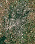
Shelby County is a county in the U.S. state of Indiana. As of the 2020 United States Census, the population was 45,055. The county seat is Shelbyville.

<span class="mw-page-title-main">Shelby County, Illinois</span> County in Illinois, United States

Shelby County is a county located in the U.S. state of Illinois. According to the 2020 census, it had a population of 20,990. Its county seat is Shelbyville.

<span class="mw-page-title-main">Shelbyville, Illinois</span> City in Illinois, United States

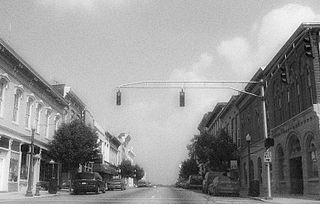
Shelbyville is a city in and the county seat of Shelby County, Illinois, United States, along the Kaskaskia River. As of the 2020 census, the population was at 4,674. HSHS Good Shepherd Hospital, located in town, is the county's only hospital. Shelbyville is also home to Chautauqua Auditorium.

<span class="mw-page-title-main">Dunlap, Indiana</span> Census-designated place in Indiana, United States

Dunlap is a census-designated place (CDP) in Elkhart County, Indiana, United States. The population was 6,235 at the 2010 census. Once a small farming community, by the 1980s it had become a suburb of Elkhart and Goshen, Indiana. Most of the town was destroyed by two violent F4 tornadoes during the Palm Sunday Tornado Outbreak on April 11, 1965.

<span class="mw-page-title-main">Galena, Indiana</span> Census-designated place in Indiana, United States

Galena is a census-designated place (CDP) in Floyd County, Indiana, United States. The population was 1,818 at the 2010 census. The CDP includes the town of Galena as well as the nearby town of Floyds Knobs and their immediate surroundings.

<span class="mw-page-title-main">Collegeville, Indiana</span> Census-designated place in Indiana, United States

Collegeville is a census-designated place (CDP) in Jasper County, Indiana, United States. The population was 330 at the 2010 census. Collegeville is home to the now-unaccredited Saint Joseph's College, the source of the town's name.

<span class="mw-page-title-main">Morristown, Indiana</span> Town in Indiana, United States

Morristown is a town in Hanover Township, Shelby County, in the U.S. state of Indiana. The population was 1,218 at the 2010 census.

<span class="mw-page-title-main">Shelbyville, Indiana</span> City in Indiana, United States

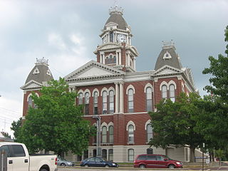
Shelbyville is a city in Addison Township, Shelby County, in the U.S. state of Indiana and is the county seat. The population was 20,067 as of the 2020 census.

<span class="mw-page-title-main">Shelbyville, Kentucky</span> City in Kentucky, United States

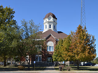
Shelbyville is a home rule-class city in and the county seat of Shelby County, Kentucky, United States. The population was 17,282 at the 2020 census.

<span class="mw-page-title-main">Fairland, Maryland</span> Census-designated place in Maryland, United States

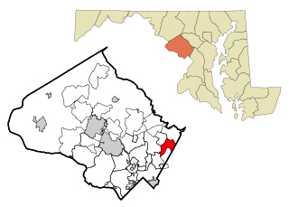
Fairland is a census-designated place and an unincorporated area in Montgomery County, Maryland, United States. It had a population of 25,396 per the 2020 census.

<span class="mw-page-title-main">Amboy, Minnesota</span> City in Minnesota, United States

Amboy is a city in Blue Earth County, Minnesota, United States. The population was 535 at the 2020 census. It is part of the Mankato-North Mankato Metropolitan Statistical Area. The city was founded in 1879. It celebrated its 125th anniversary in September 2004.

Shelby Township is a township in Blue Earth County, Minnesota, United States. The population was 294 as of the 2000 census.

<span class="mw-page-title-main">Shelbyville, Missouri</span> City in Missouri, United States

Shelbyville is a city in Shelby County, Missouri, United States. The population was 518 at the 2020 census. It is the county seat of Shelby County.

<span class="mw-page-title-main">Inverness, Montana</span> CDP in Montana, United States

Inverness is a census-designated place (CDP) in Hill County, Montana, United States. The population was 55 at the 2010 census. It was named after a city in Scotland.

<span class="mw-page-title-main">Proctorville, Ohio</span> Village in Ohio, United States

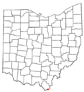
Proctorville is a village in Lawrence County, Ohio, United States, along the Ohio River. The population was 523 at the 2020 census. The East End Bridge connects Proctorville to Huntington, West Virginia across the Ohio River.

<span class="mw-page-title-main">Relampago, Texas</span> Census-designated place in Texas

Relampago is a census-designated place (CDP) in Hidalgo County, Texas, United States. The population was 129 at the 2020 United States Census. It is part of the McAllen–Edinburg–Mission Metropolitan Statistical Area.

<span class="mw-page-title-main">Windsor, Wisconsin</span> Village in Wisconsin, United States

Windsor is a village and former town in Dane County, Wisconsin. The population was 8,754 at the time of the 2020 census. The communities of Lake Windsor, Morrisonville, and Token Creek are located within the village. Windsor voted to incorporate as a village on November 3, 2015; prior to its incorporation, it was a town, and a portion of the town was a census-designated place. Windsor is a part of the Census Bureau's Madison metropolitan statistical area.

<span class="mw-page-title-main">Buffalo, Indiana</span> Census-designated place in Indiana, United States

Buffalo is a census-designated place (CDP) in Liberty Township, White County, in the U.S. state of Indiana. The population was 692 at the 2010 census.

References

  1. "2020 U.S. Gazetteer Files". United States Census Bureau. Retrieved March 16, 2022.
  2. 1 2 3 U.S. Geological Survey Geographic Names Information System: Fairland, Indiana
  3. 1 2 "U.S. Census website". United States Census Bureau . Retrieved January 31, 2008.
  4. Chadwick, Edward H. (1909). Chadwick's History of Shelby County, Indiana. B.F. Bowen. p. 267.
  5. Baker, Ronald L. (October 1995). From Needmore to Prosperity: Hoosier Place Names in Folklore and History . Indiana University Press. p.  129. ISBN   978-0-253-32866-3. ...name is descriptive of the area's "beautiful land".
  6. "Shelby County". Jim Forte Postal History. Archived from the original on December 8, 2015. Retrieved December 4, 2015.
  7. 1 2 3 Fairland History 1852-1952
  8. "G001 - Geographic Identifiers - 2010 Census Summary File 1". United States Census Bureau. Archived from the original on February 13, 2020. Retrieved July 16, 2015.
  9. Fairland makes it official [ permanent dead link ], Shelbyville News, August 18, 2008. Accessed 2008-10-25.
  10. §36-4-1.5-1 Archived September 26, 2008, at the Wayback Machine , Indiana Code. Accessed October 25, 2008.
  11. "Census of Population and Housing". Census.gov. Retrieved June 4, 2015.
  12. "U.S. Census website". United States Census Bureau . Retrieved December 11, 2012.
  13. Shelby County, Indiana History & Families. Turner Publishing Company. 1992. p. 57. ISBN   978-1-56311-078-8.
  14. "Hoosier Hopes To Become 'Nashville Star'". TheIndyChannel.com. CNN. Archived from the original on October 10, 2008. Retrieved June 7, 2012.