Lawrence, Indiana

Last updated

Lawrence, Indiana
City of Lawrence.jpg
Flag of Lawrence, Indiana.png
Marion County Indiana Incorporated and Unincorporated areas Lawrence Highlighted 1842426.svg
Location in Marion County, Indiana
Coordinates: 39°52′03″N85°59′26″W / 39.86750°N 85.99056°W / 39.86750; -85.99056
CountryUnited States
State Indiana
County Marion
Government
   Mayor Deborah Whitfield (D)
  Common Council [1] Tyrrell Giles (D, 1st)
Rick Wells (D, 2nd)
Sherron Freeman (D, 3rd)
Carlos Jennings (D, 4th)
Zach Cramer (D, 5th)
Kristina Krone (D, 6th)
Lisa Chavis (D, AL)
Liz Masur (D, AL)
Betty Robinson (D, AL)
Area
[2]
  Total20.25 sq mi (52.43 km2)
  Land20.15 sq mi (52.18 km2)
  Water0.10 sq mi (0.25 km2)
Elevation
[3]
853 ft (260 m)
Population
 (2020) [4]
  Total49,370
  Density2,450.37/sq mi (946.11/km2)
Time zone UTC-5 (EST)
  Summer (DST) UTC-4 (EDT)
ZIP codes
46216, 46226, 46235, 46236
Area code(s) 317, 463
FIPS code 18-42426 [5]
GNIS feature ID2395647 [3]
Website www.cityoflawrence.org
United States Post Office in Lawrence Lawerence, Indiana post office.jpg
United States Post Office in Lawrence
Building housing government offices in Lawrence Lawrence Government building.jpg
Building housing government offices in Lawrence

Lawrence is a city in Marion County, Indiana, United States. It is one of four "excluded cities" in Marion County. The city is home to Fort Benjamin Harrison within Fort Harrison State Park. The population was 49,370 at the 2020 census. [4] The city is on the northeast side of Indianapolis.

Contents

History

The municipality was platted in 1849 under the name "Lanesville", [6] but other names were tried because there was already another Lanesville in Indiana. The name "Jamestown", in honor of the town's founder James White, was used for a while, but in 1866 the Marion County Commissioners approved the name "Lawrence", which is also the name of the township in which it is located. The name was in honor of Captain James Lawrence, naval hero of the War of 1812. [7] In 1929 the citizens of Lawrence voted to become an independent town, where they first established the town marshal, as well as other parts of government.

In 1969, Indianapolis and Marion County adopted a unified government structure known as Unigov. Lawrence is one of four "excluded cities" and therefore retains its own municipal government. Its citizens vote not only for the mayor and council of Lawrence, but also for the mayor of Indianapolis and representatives on the Indianapolis City-County Council. [7]

Geography

Lawrence is located in northeastern Marion County. It is bordered to the east by Hancock County, including the town of McCordsville. Downtown Indianapolis is 9 miles (14 km) to the southwest. U.S. Route 36 (Pendleton Pike) runs through the city, leading northeast 22 miles (35 km) to Pendleton. US 36 intersects Interstate 465, the Indianapolis beltway, at that highway's Exit 42 at the southwest corner of Lawrence. Exit 40 on I-465, with East 56th Street and North Shadeland Avenue, is along the western border of Lawrence.

According to the U.S. Census Bureau, Lawrence has a total area of 20.25 square miles (52.45 km2), of which 0.10 square miles (0.26 km2), or 0.48%, are water. [2] Fall Creek, a southwest-flowing tributary of the White River flows through the northwest part of the city, and in places forms the city's northwest boundary. Fort Harrison State Park is in the northwest part of the city as well.

Climate

The climate in this area is characterized by hot, humid summers and generally mild to cold winters. According to the Köppen Climate Classification system, Lawrence has a humid continental climate with hot summers and year around precipitation, abbreviated "Dfa" on climate maps. [8]

Demographics

Historical population
CensusPop.Note
1880 253
1930 840
1940 1,08729.4%
1950 1,95179.5%
1960 10,103417.8%
1970 16,35361.9%
1980 25,59156.5%
1990 26,7634.6%
2000 38,91545.4%
2010 46,00118.2%
2020 49,3707.3%
Source: US Census Bureau

2010 census

At the 2010 United States Census, there were 46,001 people, 17,864 households, and 11,949 families in the city. The population density was 2,285.2 inhabitants per square mile (882.3/km2). There were 19,515 housing units at an average density of 969.4 per square mile (374.3/km2). The racial makeup of the city was 63.2% White, 25.8% African American, 0.4% Native American, 1.4% Asian, 0.1% Pacific Islander, 5.7% from other races, and 3.5% from two or more races. Hispanic or Latino of any race were 11.2%. [9]

Of the 17,864 households 38.7% had children under the age of 18 living with them, 44.2% were married couples living together, 17.5% had a female householder with no husband present, 5.3% had a male householder with no wife present, and 33.1% were non-families. 27.6% of households were one person and 8% were one person aged 65 or older. The average household size was 2.56 and the average family size was 3.12.

The median age was 34.2 years. 28.2% of residents were under the age of 18; 8.1% were between the ages of 18 and 24; 29.3% were from 25 to 44; 24.9% were from 45 to 64; and 9.6% were 65 or older. The gender makeup of the city was 47.5% male and 52.5% female.

The median household income was $54,254 in Lawrence compared to the state median of $48,393. Roughly 31% of Lawrence residents have a bachelor's degree compared to 22.7% of all Indiana residents. [10]

2000 census

At the 2000 United States Census, there were 38,915 people, 14,853 households, and 10,337 families in the city. The population density was 1,937.8 inhabitants per square mile (748.2/km2). There were 16,292 housing units at an average density of 811.3 per square mile (313.2/km2). The racial makeup of the city was 78.58% White, 15.51% African American, 0.30% Native American, 1.80% Asian, 0.08% Pacific Islander, 1.86% from other races, and 1.87% from two or more races. Hispanic or Latino of any race were 4.73%. [5]

Of the 14,853 households 39.8% had children under the age of 18 living with them, 52.1% were married couples living together, 13.0% had a female householder with no husband present, and 30.4% were non-families. 24.8% of households were one person and 5.9% were one person aged 65 or older. The average household size was 2.60 and the average family size was 3.13.

The population was diversified at 29.9% under the age of 18, 7.7% from 18 to 24, 36.2% from 25 to 44, 18.0% from 45 to 64, and 8.2% 65 or older. The median age was 32 years. For every 100 females, there were 95.2 males. For every 100 females age 18 and over, there were 91.3 males.

The median household income was $47,838 and the median family income was $56,609. Males had a median income of $38,924 versus $30,406 for females. The per capita income for the city was $22,543. About 4.8% of families and 6.7% of the population were below the poverty line, including 8.2% of those under age 18 and 5.1% of those age 65 or over.

Education

The Lawrence Township school district is the ninth largest and one of the fastest growing districts in the state. It operates four Early Learning Centers, eleven elementary magnet schools (grades 1–6), two middle schools (grades 7–8), two high schools (Lawrence Central and Lawrence North), a center for innovation and technology, and an alternative setting high school. [11] In the 2018–2019 academic year there were 16,035 students with a high school graduation rate of 92.7%. Lawrence Township schools offer high ability programs, Advanced Placement (AP and ACP), International Baccalaureate Program, vocational and career education programs, and bilingual programs. [12] The district holds 45 state championships and 5 national titles in various inter-curricular competitions. Those titles include championships in basketball (Lawrence North - 2006) and marching band (Lawrence Central -1998, 2001 and 2004). [13] The diversity makeup of the district is .05% American Indian, 23.5% White, 45.3% Black, 6.9% Multiracial, 1.1% Asian, .05% Pacific Islander, and 23.1% Hispanic, as of the 2017–18 school year. [14] Lawrence also has a public library, a branch of the Indianapolis Public Library. [15]

Notable residents

Related Research Articles

<span class="mw-page-title-main">Alexandria, Indiana</span> City in Indiana, United States

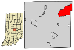
Alexandria is a city in Monroe Township, Madison County, Indiana, United States. It is about 48 miles (77 km) northeast of Indianapolis. According to the 2020 census, its population was 5,149, nearly unchanged from 2010.

<span class="mw-page-title-main">Marion County, Indiana</span> County in Indiana, United States

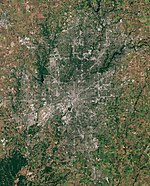
Marion County is located in the U.S. state of Indiana. The 2020 United States census reported a population of 977,203, making it the most populous county in the state and 51st most populated county in the country. Indianapolis is the county seat, the state capital, and most populous city. Marion County is consolidated with Indianapolis through an arrangement known as Unigov.

<span class="mw-page-title-main">Hamilton County, Indiana</span> County in Indiana, United States

Hamilton County is a county in the U.S. state of Indiana. The 2020 United States Census recorded a population of 347,467. The county seat is Noblesville.

<span class="mw-page-title-main">Zionsville, Indiana</span> Town in Indiana, United States

Zionsville is a suburban town located in the extreme southeast area of Boone County, Indiana, United States, northwest of Indianapolis. The population was 14,160 at the 2010 census, 30,693 at the 2020 census.

<span class="mw-page-title-main">Switz City, Indiana</span> Town in Indiana, United States

Switz City is a town in Fairplay and Grant townships, Greene County, Indiana, United States. The population was 293 at the 2010 census. It is part of the Bloomington, Indiana, Metropolitan Statistical Area.

<span class="mw-page-title-main">Fortville, Indiana</span> Town in Indiana, United States

Fortville is a town in Vernon Township, Hancock County, Indiana, United States. The population was 4,784 at the 2020 census.

<span class="mw-page-title-main">Lanesville, Indiana</span> Town in Indiana, United States

Lanesville is a town in Franklin Township, Harrison County, Indiana, United States. The population was 935 at the 2010 census.

<span class="mw-page-title-main">Avon, Indiana</span> Town in Indiana, United States

Avon is a town in Washington Township, Hendricks County, Indiana, United States. The population was 21,474 at the 2020 census. It is part of the Indianapolis metropolitan area.

<span class="mw-page-title-main">Whiteland, Indiana</span> Town in Indiana, United States

Whiteland is a town in Pleasant, Franklin and Clark townships, Johnson County, Indiana, United States. The population was 4,599 at the 2020 census.

<span class="mw-page-title-main">River Forest, Indiana</span> Town in Indiana, United States

River Forest is a town in Anderson Township, Madison County, Indiana, United States. It is part of the Indianapolis–Carmel–Anderson metropolitan statistical area. The population was 26 at the 2020 census.

<span class="mw-page-title-main">Southport, Indiana</span> City in Indiana, United States

Southport is an excluded city in Marion County, Indiana, United States. The population was 2,123 at the 2020 census, up from 1,712 in 2010.

<span class="mw-page-title-main">Speedway, Indiana</span> Town in the United States

Speedway is a town in Wayne Township, Marion County, Indiana, United States. The population was 13,952 at the 2020 census, up from 11,812 in 2010. Speedway, which is an enclave of Indianapolis, is the home of the Indianapolis Motor Speedway.

<span class="mw-page-title-main">Martinsville, Indiana</span> City in Indiana, United States

Martinsville is a city in Washington Township, Morgan County, in the U.S. state of Indiana. The population was 12,309 at the 2020 United States Census. The city is the county seat of Morgan County.

<span class="mw-page-title-main">Rockville, Indiana</span> Town in Indiana, United States

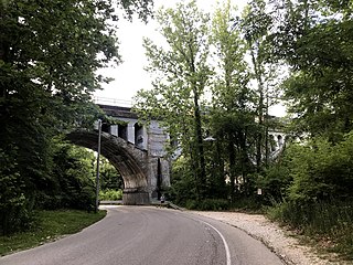
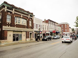
Rockville is a town in Adams Township, Parke County, in the U.S. state of Indiana. The population was 2,607 at the 2010 census. The town is the county seat of Parke County. It is known as "The Covered Bridge Capital of the World".

<span class="mw-page-title-main">Mount Vernon, Indiana</span> City in Indiana, United States

Mount Vernon is a city in and the county seat of Posey County, Indiana, United States. Located in the state's far southwestern corner, within 15 miles (24 km) of both the southernmost or westernmost points, it is the westernmost city in the state. The southernmost is Rockport, located along the Ohio River about 40 miles (64 km) to the southeast.

<span class="mw-page-title-main">Shelbyville, Indiana</span> City in Indiana, United States

Shelbyville is a city in Addison Township, Shelby County, in the U.S. state of Indiana and is the county seat. The population was 20,067 as of the 2020 census.

<span class="mw-page-title-main">Fenton Township, Michigan</span> Charter township in Michigan, United States

Charter Township of Fenton is a charter township of Genesee County in the U.S. state of Michigan. The population was 15,552 at the 2010 census.

<span class="mw-page-title-main">Fife Lake, Michigan</span> Village in Michigan, United States

Fife Lake is a village in southeastern Grand Traverse County in the U.S. state of Michigan. Its population was 456 at the 2020 census, up from 443 at the 2010 census. The village is part of the Traverse City metropolitan area, and lies upon the shore of the lake of the same name.

<span class="mw-page-title-main">North Crows Nest, Indiana</span> Town in Indiana, United States

North Crows Nest is a town in Washington Township, Marion County, Indiana, United States. It is approximately 7 miles (11 km) north of downtown Indianapolis. The population was 44 at the 2020 census. It has existed as an "included town" since 1970, when it was incorporated into Indianapolis as part of Unigov. It is part of Indianapolis, but retains town governmental powers under IC 36-3-1-11.

<span class="mw-page-title-main">Warren Park, Indiana</span> Town in Indiana, United States

Warren Park is a town in Warren Township, Marion County, Indiana, United States. The population was 1,490 at the 2020 census. It has existed as an "included town" since 1970, when it was incorporated into Indianapolis as part of Unigov. It is part of Indianapolis, but retains a functioning town government under IC 36-3-1-11.

References

  1. "Common Council". City of Lawrence, IN. Retrieved April 22, 2016.
  2. 1 2 "2022 U.S. Gazetteer Files: Indiana". United States Census Bureau. Retrieved April 13, 2023.
  3. 1 2 U.S. Geological Survey Geographic Names Information System: Lawrence, Indiana
  4. 1 2 "P1. Race – Lawrence city, Indiana: 2020 DEC Redistricting Data (PL 94-171)". U.S. Census Bureau. Retrieved April 13, 2023.
  5. 1 2 "US Census website". US Census Bureau. Retrieved January 31, 2008.
  6. Bodenhamer, David J.; Barrows, Robert G. (November 22, 1994). The Encyclopedia of Indianapolis. Indiana University Press. p. 899. ISBN   0-253-11249-4.
  7. 1 2 "City History". City of Lawrence.
  8. Climate Classification Map
  9. "US Census website". US Census Bureau. Retrieved December 11, 2012.
  10. "Economic Development". City of Lawrence.
  11. "Choose LT". Metropolitan School District Lawrence Township.
  12. "Academics". Metropolitan School District Lawrence Township.
  13. "About". Metropolitan School District Lawrence Township.
  14. "Metropolitan School District of Lawrence Township Ten Year Ethnic Summary" (PDF). Metropolitan School District of Lawrence Township. Retrieved March 30, 2019.
  15. "Locations & Hours". Indianapolis Public Library. Retrieved March 10, 2018.