Spencer County, Indiana

Last updated

Spencer County
Spencer County Courthouse in Rockport.jpg
Map of Indiana highlighting Spencer County.svg
Location within the U.S. state of Indiana
Indiana in United States.svg
Indiana's location within the U.S.
Coordinates: 38°01′N87°01′W / 38.01°N 87.01°W / 38.01; -87.01
CountryFlag of the United States.svg United States
StateFlag of Indiana.svg  Indiana
FoundedJanuary 10, 1818
Named for Spier Spencer
Seat Rockport
Largest town Santa Claus
Area
  Total401.43 sq mi (1,039.7 km2)
  Land396.74 sq mi (1,027.6 km2)
  Water4.68 sq mi (12.1 km2)
Population
 (2020)
  Total19,810 Decrease2.svg
  Density49.9/sq mi (19.3/km2)
Time zone UTC−6 (Central)
  Summer (DST) UTC−5 (CDT)
Congressional district 8th
Website spencercounty.in.gov
Indiana county number 74

Spencer County is a county located in the U.S. state of Indiana. As of the 2020 census, the population was 19,810. [1] The county seat is Rockport. [2] Despite not being in the Owensboro Metropolitan Area, the entire riverfront of the city of Owensboro, Kentucky borders the southern tip of the county.

Contents

History

Spencer County was formed in 1818 from parts of Warrick County and Perry County. It was named for Captain Spier Spencer, killed at the Battle of Tippecanoe in 1811. He was also the namesake for Spencer, Indiana, the county seat of Owen County. [3]

Abraham Lincoln lived in Spencer County from 1816 to 1830, between the ages of seven and twenty-one. Originally, the area his family settled in was in Perry County with Spencer County being formed almost two years later. His family moved to Illinois in 1830. The Lincoln Boyhood National Memorial is located at the site of the Lincoln family farm. In addition, the graves of his mother Nancy Lincoln and sister Sarah Lincoln Grigsby are located in Spencer County.

On December 16, 1900, two African-American men, Bud Rowlands and Jim Henderson, were lynched by the county courthouse in Rockport after being arrested as suspects in the brutal robbery and killing of a white barber at 2 am the night before. A mob estimated at 1,500 broke open the jail and took them out, hanging them from a tree by the courthouse, and shooting their bodies numerous times. [4] John Rolla was accused by Rowlands as a suspect and also lynched. [5] This was the second-highest number of lynchings in the state, though it pales in comparison to lynchings in Southern states. [6]

The current Spencer County courthouse was built in 1921. It is the fifth courthouse to serve the county. [7]

County attractions include the town of Santa Claus, Holiday World & Splashin' Safari, and Santa's Candy Castle.

Saint Meinrad Archabbey is located at the northeastern corner of Spencer County.

Geography

According to the 2010 census, the county has a total area of 401.43 square miles (1,039.7 km2), of which 396.74 square miles (1,027.6 km2) (or 98.83%) is land and 4.68 square miles (12.1 km2) (or 1.17%) is water. [8]

Cities and towns

ZIP Codes are in parentheses.

Census-designated place

Other unincorporated places

Townships

Adjacent counties

Major highways

National protected area

Climate and weather

Rockport, Indiana
Climate chart (explanation)
J
F
M
A
M
J
J
A
S
O
N
D
 
 
3.5
 
 
43
24
 
 
3.9
 
 
49
29
 
 
4.3
 
 
59
37
 
 
4.7
 
 
70
45
 
 
4.8
 
 
79
55
 
 
3.6
 
 
87
64
 
 
3.8
 
 
91
68
 
 
3.5
 
 
90
65
 
 
3.5
 
 
83
58
 
 
3
 
 
73
46
 
 
4.1
 
 
59
37
 
 
3.9
 
 
47
29
Average max. and min. temperatures in °F
Precipitation totals in inches
Source: The Weather Channel [9]
Metric conversion
J
F
M
A
M
J
J
A
S
O
N
D
 
 
88
 
 
6
−4
 
 
98
 
 
9
−2
 
 
108
 
 
15
3
 
 
118
 
 
21
7
 
 
121
 
 
26
13
 
 
92
 
 
31
18
 
 
97
 
 
33
20
 
 
90
 
 
32
18
 
 
89
 
 
28
14
 
 
76
 
 
23
8
 
 
104
 
 
15
3
 
 
99
 
 
8
−2
Average max. and min. temperatures in °C
Precipitation totals in mm

In recent years, average temperatures in Rockport have ranged from a low of 24 °F (−4 °C) in January to a high of 91 °F (33 °C) in July, although a record low of −23 °F (−31 °C) was recorded in January 1994 and a record high of 107 °F (42 °C) was recorded in June 1944. Average monthly precipitation ranged from 3.01 inches (76 mm) in October to 4.78 inches (121 mm) in May. [9]

Government

The county government is a constitutional body, and is granted specific powers by the Constitution of Indiana, and by the Indiana Code.

County Council: The county council is the legislative branch of the county government and controls all the spending and revenue collection in the county. Representatives are elected from county districts. The council members serve four-year terms. They are responsible for setting salaries, the annual budget, and special spending. The council also has limited authority to impose local taxes, in the form of an income and property tax that is subject to state level approval, excise taxes, and service taxes. [10] [11]

Board of Commissioners: The executive body of the county is made of a board of commissioners. The commissioners are elected county-wide, in staggered terms, and each serves a four-year term. One of the commissioners, typically the most senior, serves as president. The commissioners are charged with executing the acts legislated by the council, collecting revenue, and managing the day-to-day functions of the county government. [10] [11]

Court: The county maintains a small claims court that can handle some civil cases. The judge on the court is elected to a term of four years and must be a member of the Indiana Bar Association. The judge is assisted by a constable who is also elected to a four-year term. In some cases, court decisions can be appealed to the state level circuit court. [11]

County Officials: The county has several other elected offices, including sheriff, coroner, auditor, treasurer, recorder, surveyor, and circuit court clerk. Each of these elected officers serves a term of four years and oversees a different part of county government. Members elected to county government positions are required to declare party affiliations and to be residents of the county. [11]

Spencer County is part of Indiana's 8th congressional district and is represented in Congress by Republican Larry Bucshon.

United States presidential election results for Spencer County, Indiana [12]
Year Republican Democratic Third party
No.%No.%No.%
2020 7,35768.19%3,21329.78%2192.03%
2016 6,57265.41%2,86128.47%6156.12%
2012 5,51556.60%4,02641.32%2032.08%
2008 5,00149.05%5,03949.42%1561.53%
2004 5,93459.79%3,92039.50%700.71%
2000 5,09656.70%3,75241.75%1391.55%
1996 3,77043.74%4,05847.08%7929.19%
1992 3,78939.56%4,30144.90%1,48915.54%
1988 4,96454.82%4,06144.85%300.33%
1984 5,81659.07%4,00540.68%250.25%
1980 5,28454.45%4,15342.79%2682.76%
1976 4,16646.34%4,79653.35%280.31%
1972 5,51858.61%3,86741.07%300.32%
1968 4,60351.18%3,76741.89%6236.93%
1964 3,98045.05%4,83454.72%200.23%
1960 5,05053.88%4,30345.91%200.21%
1956 5,40460.31%3,53039.40%260.29%
1952 5,49761.48%3,40138.04%430.48%
1948 4,49651.52%4,16347.71%670.77%
1944 4,98657.40%3,64741.99%530.61%
1940 5,66757.31%4,18042.27%420.42%
1936 4,56747.20%4,96651.32%1431.48%
1932 4,01442.24%5,42257.06%670.71%
1928 4,67252.83%4,15246.95%200.23%
1924 4,39548.59%4,40948.75%2412.66%
1920 5,27057.03%3,85541.72%1151.24%
1916 2,56050.34%2,33545.92%1903.74%
1912 1,26824.80%2,42847.50%1,41627.70%
1908 2,92051.54%2,66246.98%841.48%
1904 3,01753.57%2,49544.30%1202.13%
1900 2,97950.55%2,81647.79%981.66%
1896 3,04752.34%2,74547.15%300.52%
1892 2,47847.96%2,49648.31%1933.74%
1888 2,73350.22%2,68549.34%240.44%

Demographics

Historical population
CensusPop.Note
1820 1,882
1830 3,19669.8%
1840 6,30597.3%
1850 8,61636.7%
1860 14,55668.9%
1870 17,99823.6%
1880 22,12222.9%
1890 22,060−0.3%
1900 22,4071.6%
1910 20,676−7.7%
1920 18,400−11.0%
1930 16,713−9.2%
1940 16,211−3.0%
1950 16,174−0.2%
1960 16,074−0.6%
1970 17,1346.6%
1980 19,36113.0%
1990 19,4900.7%
2000 20,3914.6%
2010 20,9522.8%
2020 19,810−5.5%
2023 (est.)19,910 [13] 0.5%
U.S. Decennial Census [14]
1790-1960 [15] 1900-1990 [16]
1990-2000 [17] 2010 [18]

As of the 2010 United States Census, there were 20,952 people, 8,082 households, and 5,907 families residing in the county. [19] The population density was 52.8 inhabitants per square mile (20.4/km2). There were 8,872 housing units at an average density of 22.4 per square mile (8.6/km2). [8] The racial makeup of the county was 96.9% White, 0.5% Black or African American, 0.3% Asian, 0.2% American Indian, 1.3% from other races, and 0.8% from two or more races. Those of Hispanic or Latino origin made up 2.5% of the population. [19] In terms of ancestry, 47.0% were German, 16.4% were Irish, 12.6% were English, and 11.1% were American. [20]

Of the 8,082 households, 33.5% had children under the age of 18 living with them, 60.8% were married couples living together, 8.1% had a female householder with no husband present, 26.9% were non-families, and 23.2% of all households were made up of individuals. The average household size was 2.55 and the average family size was 3.00. The median age was 41.9 years. [19]

The median income for a household in the county was $47,697 and the median income for a family was $61,365. Males had a median income of $44,526 versus $30,466 for females. The per capita income for the county was $23,609. About 6.8% of families and 12.1% of the population were below the poverty line, including 18.0% of those under age 18 and 12.8% of those age 65 or over. [21]

Notable people

It is the birthplace of H. Justin Davidson, Ken Dilger, Del Harris, Florence Henderson, Roger Kaiser, Bill Peet, Brig General Thomas Gamble Pitcher, and Howard Schnellenberger. Another notable figure that grew up here was Abraham Lincoln, who was the 16th President of the United States.

See also

Related Research Articles

<span class="mw-page-title-main">White County, Indiana</span> County in Indiana, United States

White County is a county in the U.S. state of Indiana. As of the 2020 United States Census, the population was 24,688. The county seat is Monticello.

<span class="mw-page-title-main">Wabash County, Indiana</span> County in Indiana, United States

Wabash County is a county located in the northern central part of the U.S. state of Indiana. As of 2020, the population was 30,976. The county seat is Wabash.

<span class="mw-page-title-main">Ripley County, Indiana</span> County in Indiana, United States

Ripley County is a county located at the southeastern corner of the U.S. state of Indiana. According to the 2020 Census, the population was 28,995. The county seat is Versailles.

<span class="mw-page-title-main">Pulaski County, Indiana</span> County of Indiana, United States

Pulaski County is a county located in the U.S. state of Indiana. According to the 2020 U.S. census, the population was 12,514. The county seat is Winamac.

<span class="mw-page-title-main">Owen County, Indiana</span> County in Indiana, United States

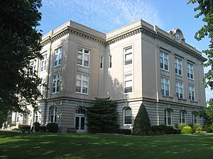
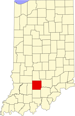
Owen County is a county in the U.S. state of Indiana. In 1920 the United States Census Bureau calculated the mean center of U.S. population to fall within this county. As of the 2020 United States Census, it had a population of 21,321. Its county seat is Spencer.

<span class="mw-page-title-main">Ohio County, Indiana</span> County in Indiana, United States

Ohio County is a county located in southeastern Indiana. With a 2020 population of 5,940, and an area of just 87 square miles, Ohio County is the smallest county in Indiana by area and the least populous. The county seat and only incorporated municipality is Rising Sun. The county was officially established in 1844 and was one of the last Indiana counties to be created. Ohio County borders the state of Kentucky across the Ohio River for which it was named. It is part of the Cincinnati, OH-KY-IN Metropolitan Statistical Area. The county is divided into four townships which provide local services. Three state roads pass through or into the county.

<span class="mw-page-title-main">Morgan County, Indiana</span> County in Indiana, United States

Morgan County is a county located in the U.S. state of Indiana. As of the 2020 United States Census, the population was 71,780. The county seat is Martinsville.

<span class="mw-page-title-main">Lawrence County, Indiana</span> County in Indiana, United States

Lawrence County is a county located in the U.S. state of Indiana. As of 2020, the population was 45,011. The county seat is Bedford. Lawrence County comprises the Bedford, IN Micropolitan Statistical Area.

<span class="mw-page-title-main">Johnson County, Indiana</span> County in Indiana, United States

Johnson County is a county located in the U.S. state of Indiana. As of 2020, the population was 161,765. The county seat is Franklin.

<span class="mw-page-title-main">Jennings County, Indiana</span> County in Indiana, United States

Jennings County is a county located in the U.S. state of Indiana. As of 2020, the population was 27,613. The county seat is Vernon.

<span class="mw-page-title-main">Jefferson County, Indiana</span> County in Indiana, United States

Jefferson County is a county located in the U.S. state of Indiana. As of 2020, the population was 33,147. The county seat is Madison.

<span class="mw-page-title-main">Howard County, Indiana</span> County in Indiana, United States

Howard County is one of 92 counties in the U.S. state of Indiana. As of the 2020 census, the population was 83,658. The county seat is Kokomo. Originally named Richardville County, it was renamed in 1846 to commemorate General Tilghman Ashurst Howard.

<span class="mw-page-title-main">Henry County, Indiana</span> County in Indiana, United States

Henry County is a county located in east central Indiana, United States. As of 2020, the population was 48,914. The county seat and largest and only city is New Castle. Henry County is the main setting of the novel Raintree County by Ross Lockridge Jr.

<span class="mw-page-title-main">Dubois County, Indiana</span> County in Indiana, United States

Dubois County is a county located in the U.S. state of Indiana. As of 2020, the population was 43,637. The county seat is Jasper. Dubois County is now the sole county of the Jasper Micropolitan Statistical Area.

<span class="mw-page-title-main">Crawford County, Indiana</span> County in Indiana, United States

Crawford County is a county located in the U.S. state of Indiana. As of 2020, the population was 10,526. The county seat is English.

<span class="mw-page-title-main">Carroll County, Indiana</span> County in Indiana, United States

Carroll County is a county located in the U.S. state of Indiana. As of the 2020 United States Census, the population was 20,306. The county seat is Delphi.

<span class="mw-page-title-main">Bartholomew County, Indiana</span> County in Indiana, United States

Bartholomew County is a county located in the U.S. state of Indiana. The population was 82,208 at the 2020 census. The county seat is Columbus. The county was determined by the U.S. Census Bureau to be home to the mean center of U.S. population in 1900.

<span class="mw-page-title-main">Lincoln County, Colorado</span> County in Colorado, United States

Lincoln County is a county located in the U.S. state of Colorado. As of the 2020 census, the population was 5,675. The county seat is Hugo. The county obtains its name in memory of the United States President Abraham Lincoln. County was formed from portions of Bent and Elbert counties in 1889 from a restructuring of Colorado counties.

<span class="mw-page-title-main">Dale, Indiana</span> Town in Indiana, United States

Dale is a town in Carter Township, Spencer County, in the U.S. state of Indiana. The population was 1,593 at the 2010 census.

<span class="mw-page-title-main">Rockport, Indiana</span> City in Indiana, United States

Rockport is a city in Ohio Township and the county seat of Spencer County, Indiana, along the Ohio River. The population was 2,270 at the 2010 census. Once the largest community in Spencer County, the city has recently been surpassed by the town of Santa Claus. At 37°53'1" north, Rockport is also the southernmost city in the state, located slightly south of Evansville, Cannelton, or Mount Vernon.

References

  1. "Spencer County, Indiana". United States Census Bureau . Retrieved June 7, 2023.
  2. "Find a County". National Association of Counties. Retrieved June 7, 2011.
  3. De Witt Clinton Goodrich & Charles Richard Tuttle (1875). An Illustrated History of the State of Indiana. Indiana: R. S. Peale & co. pp.  572.
  4. Butte Weekly Miner, 20 December 1900; accessed 31 May 2018
  5. Dawn Mitchell and Maureen C. Gilmer, "Last-known lynching in Indiana included in National Memorial for Peace and Justice", Indy Star, April 30, 2018; accessed May 31, 2018
  6. "Lynching in America; Supplement: Lynching by County, 3rd edition, 2017, Montgomery, Alabama: Equal Justice Initiative, p. 5" (PDF). Archived from the original (PDF) on October 23, 2017. Retrieved May 31, 2018.
  7. Wissing, Douglas (March 1, 2001). Indiana. Globe Pequot. p. 24. ISBN   9781560449065 . Retrieved October 16, 2013.
  8. 1 2 "Population, Housing Units, Area, and Density: 2010 - County". United States Census Bureau. Archived from the original on February 12, 2020. Retrieved July 10, 2015.
  9. 1 2 "Monthly Averages for Rockport, Indiana". The Weather Channel. Retrieved January 27, 2011.
  10. 1 2 Indiana Code. "Title 36, Article 2, Section 3". IN.gov. Retrieved September 16, 2008.
  11. 1 2 3 4 Indiana Code. "Title 2, Article 10, Section 2" (PDF). IN.gov. Retrieved September 16, 2008.
  12. Leip, David. "Dave Leip's Atlas of U.S. Presidential Elections". uselectionatlas.org. Retrieved May 20, 2018.
  13. "Annual Estimates of the Resident Population for Counties: April 1, 2020 to July 1, 2023". United States Census Bureau. Retrieved April 2, 2024.
  14. "U.S. Decennial Census". United States Census Bureau. Retrieved July 10, 2014.
  15. "Historical Census Browser". University of Virginia Library. Retrieved July 10, 2014.
  16. "Population of Counties by Decennial Census: 1900 to 1990". United States Census Bureau. Retrieved July 10, 2014.
  17. "Census 2000 PHC-T-4. Ranking Tables for Counties: 1990 and 2000" (PDF). United States Census Bureau. Retrieved July 10, 2014.
  18. "Spencer County QuickFacts". United States Census Bureau . Retrieved September 25, 2011.
  19. 1 2 3 "DP-1 Profile of General Population and Housing Characteristics: 2010 Demographic Profile Data". United States Census Bureau. Archived from the original on February 13, 2020. Retrieved July 10, 2015.
  20. "DP02 SELECTED SOCIAL CHARACTERISTICS IN THE UNITED STATES – 2006-2010 American Community Survey 5-Year Estimates". United States Census Bureau. Archived from the original on February 14, 2020. Retrieved July 10, 2015.
  21. "DP03 SELECTED ECONOMIC CHARACTERISTICS – 2006-2010 American Community Survey 5-Year Estimates". United States Census Bureau. Archived from the original on February 14, 2020. Retrieved July 10, 2015.

38°01′N87°01′W / 38.01°N 87.01°W / 38.01; -87.01