St Mary Bourne is a village and civil parish in the Basingstoke and Deane district of Hampshire, England. It lies on the valley of the Bourne Rivulet, a tributary of the River Test, 5 miles (8.0 km) northeast of Andover.

Fyfield is a village and civil parish in the English county of Wiltshire, in the Kennet Valley about 2.5 miles (4.0 km) west of Marlborough. The village is on the A4 road which was historically the main route from London to the west of England.

West Overton is a village and civil parish in the English county of Wiltshire, about 3.5 miles (5.6 km) west of Marlborough. The river Kennet runs immediately north of the village, separating it from the A4 road. The parish includes the village of Lockeridge, also near the river, further east (downstream).
Lockeridge is a village in Wiltshire, England. It lies at the edge of the West Woods in the Kennet Valley, 2.9 miles (4.7 km) west of Marlborough, 3.1 miles (5.0 km) east of Avebury and 10.5 miles (16.9 km) south of Swindon. It is 0.6 miles (0.97 km) south of the A4 road which was historically the main route from London to the west of England. Lockeridge Dene is a hamlet immediately southwest of the village.
Exton is a small village and civil parish in the City of Winchester district of Hampshire, England. The village lies in the South Downs National Park, on the west bank of the River Meon, immediately to the north of Corhampton. It is located two miles north of Droxford and five miles north-east of Bishop's Waltham. Its name first appears in 940 as East Seaxnatune, meaning "farmstead of the East Saxons".
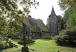
Cheriton is a village and civil parish near Alresford in Hampshire, England.

Sandleheath is a village and civil parish about 1.8 miles (2.9 km) west of Fordingbridge in the New Forest District of Hampshire, England. It has a population of 663, increasing to 680 at the 2011 Census. It lies immediately north-east of the traditional tripoint between Hampshire, Dorset and Wiltshire.

Hale is a small village and civil parish in Hampshire, England. It lies on the border of the New Forest, overlooking the valley of the River Avon. The village is about 3.5 miles (5.6 km) north-east of the town of Fordingbridge, and about 8 miles (13 km) south of the city of Salisbury. Within the parish stands Hale House, a large 18th-century mansion which was the country house of architect Thomas Archer, who also rebuilt Hale church in 1717.

Highclere is a village and civil parish situated in the North Wessex Downs in the Basingstoke and Deane district of Hampshire, England. It lies in the northern part of the county, near the Berkshire border. It is most famous for being the location of Highclere Castle, a noted Victorian house of the Earl of Carnarvon. It is the setting for numerous films and TV series, including Downton Abbey.
Lindford is a village and civil parish in the East Hampshire district of Hampshire, England. It is approximately 1 mile (1.6 km) northeast of Bordon, and west of Headley, East Hampshire on the B3004 road.

Mortimer West End is a village and civil parish in north Hampshire in England. It lies in the northernmost point of the county.

Fyfield is a village and former civil parish, now in the parish of Fyfield and Tubney, in the Vale of White Horse district, in the county of Oxfordshire, England. It is about 4+1⁄2 miles (7 km) west of Abingdon-on-Thames. It was part of Berkshire until the 1974 boundary changes transferred it to Oxfordshire. The village used to be on the main A420 road between Oxford and Faringdon, but a bypass now carries the main road just south of the village. In 1951 the parish had a population of 280. On 1 April 1952 the parish was abolished and merged with Tubney to form "Fyfield and Tubney".

Fyfield is a village and civil parish in the Epping Forest district of Essex, England.
Hawkley is a village, ecclesiastical parish and civil parish in the East Hampshire district of Hampshire, England. It is 3.5 miles (5.7 km) north of Petersfield, to the west of the A3 road.

Kimpton is a village and civil parish in the Test Valley district of Hampshire, England. The village is situated west of Andover, in the north of the county, and has a boundary with Ludgershall, in Wiltshire. South of Kimpton there is Thruxton motor racing circuit, in the parish of Thruxton.
Shelley is a partly rural village and partly residential conurbation in the Ongar civil parish of the Epping Forest district of Essex, England.
Redenham is a small village in the civil parish of Appleshaw in the Test Valley district of Hampshire, England. It is in the civil Parish of Fyfield. Its nearest town is Andover, which lies approximately 4.8 miles (7.7 km) south-east from the village.
Fyfield and Tubney is a civil parish in The Vale of White Horse district of Oxfordshire, England. It includes the village of Fyfield which is about 4.5 miles (7 km) west of Abingdon and Tubney, which is about 4 miles (6 km) west of Abingdon. The parish was formed in 1952 when the parish of Fyfield was merged with the parish of Tubney. It was part of Berkshire until the 1974 boundary changes transferred it to Oxfordshire.

Tubney is a small village and former civil parish, now in the parish of Fyfield and Tubney, in the Vale of White Horse district, in Oxfordshire, England. It lies about 3 miles west of Abingdon-on-Thames, just south of the A420 road from Oxford to Faringdon, 9 miles (14 km) southwest of Oxford. In 1951 the parish had a population of 215.