History of Hampshire

Last updated

Hampshire in 1832 Hampshire Administrative Map 1832.png
Hampshire in 1832

Hampshire is a county in Southern England with some notable archaeology and many notable historic buildings.

Contents

The chalk downland of the South Downs and southern edges of Salisbury Plain were settled in the neolithic, and these settlers built hill forts such as Winklebury and may have farmed the valleys of Hampshire. Hampshire was part of an Ancient British kingdom the Celts called Gwent (not be confused with the county in Wales) or Y Went, describing the county's open downs, which also covered areas that would later belong to Somerset and Wiltshire. [1] In the Roman invasion of Britain, Hampshire was one of the first areas to fall to the invading forces.

During the period of Anglo-Saxon settlement, modern Hampshire and the Isle of Wight were occupied by Jutish tribes – a people separate initially from the Saxons and Angles. Jutes founded kingdoms known as Wihtwara (Wight), Meonwara (Meon Valley) and Ytene (in an area similar to the later site of the New Forest). According to St Bede, however, the Jutes were conquered by the surrounding Saxon kingdoms during the 7th century. Hamtunscīr (after Hamtun, the original name of Southampton) was one of the first Saxon shires to be recorded, in 755.

For two centuries Hampshire represented the western frontier of Saxon England, as the Britons fought off advances into Dorset and Somerset. After the Saxons advanced west Hampshire became the centre of the Kingdom of Wessex, and many Saxon kings are buried at Winchester. A statue in Winchester celebrates the powerful King Alfred, who stabilised the region in the 9th century.

After the Norman Conquest the county was favoured by Norman kings who established the New Forest as a hunting forest. The county was recorded in the Domesday Book divided into 44 hundreds. [2] These later consolidated to 37. These were Alton, Andover, Barmanstip, Barton Stacey, Basingstoke, Bedbridge, Bondsborough, Bosmere, Buddlesgate, Christchurch, Chutely, Crondall, East Meon, Evinger, Fawley, Finchdean, Fordingbridge, Hambledon, Heling, Holdsett, King's Somborne, Kingsclere, Mansbridge, Meanstoke, Micheldever, New Forest, Odiham, Overton, Pastrow, Portsdown, Ringwood, Shelbourn, Sutton, Thorngate, Titchfield, Waltham and Wherwell.

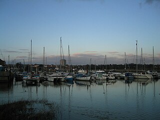
Over several centuries a series of castles and forts were constructed along the coast of the Solent to defend the harbours at Southampton and Portsmouth. These include the Norman Portchester Castle which overlooks Portsmouth Harbour, and a series of forts built by Henry VIII including Hurst Castle, situated on a sand spit at the mouth of the Solent, Calshot Castle on another spit at the mouth of Southampton Water, and Netley Castle. Southampton and Portsmouth remained important harbours when rivals, such as Poole and Bristol declined, as they are amongst the few locations that combine shelter with deep water. Southampton has been host to many famous ships, including the Mayflower and the Titanic , the latter being crewed largely by Hampshire natives.

Hampshire played a large role in World War II due to its large Royal Navy harbour at Portsmouth, the army camp at Aldershot and the military Netley Hospital on Southampton Water, as well as its proximity to the army training ranges on Salisbury Plain and the Isle of Purbeck. Supermarine, the designers of the Spitfire and other military aircraft, were based in Southampton, which led to severe bombing of the city. Aldershot remains one of the British Army's main permanent camps.

The county has in the past been called "Southamptonshire" and appears as such on some Victorian maps. The name of the administrative county was changed from 'County of Southampton' to 'County of Hampshire' on 1 April 1959. The short form of the name, often used in postal addresses, is Hants.

The old name appears as the place of embarkation of many of the immigrants into Ellis Island. It is recorded in the Commonwealth Instrument of Government, 1653, which was adopted by Oliver Cromwell when he assumed the office of Lord Protector in 1654.

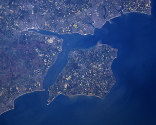
The Isle of Wight has been for some purposes in the past treated traditionally part of Hampshire, but has been administered separately from Hampshire for over a century, obtaining a county council of its own in 1890. The Isle of Wight became a full ceremonial county in 1974. The island is excluded from the hundreds given above – it was traditionally divided into East Medina and West Medina hundreds. Apart from a shared police force there are now no formal administrative links between the Isle of Wight and Hampshire.

The towns of Bournemouth and Christchurch also fall within the historic county of Hampshire.

See also

Related Research Articles

<span class="mw-page-title-main">Hampshire</span> County of England

Hampshire is a ceremonial county in South East England. It is bordered by Berkshire to the north, Surrey and West Sussex to the east, the Isle of Wight across the Solent to the south, Dorset to the west, and Wiltshire to the north-west. The cities of Portsmouth and Southampton are the largest settlements and the county town is the city of Winchester.

<span class="mw-page-title-main">Jutes</span> North Sea Germanic ethnic group from the Jutlandic peninsula

The Jutes were one of the Germanic tribes who settled in Great Britain after the departure of the Romans. According to Bede, they were one of the three most powerful Germanic nations, along with the Angles and the Saxons:

Those who came over were of the three most powerful nations of Germany—Saxons, Angles, and Jutes. From the Jutes are descended the people of Kent, and of the Isle of Wight, and those also in the province of the West Saxons who are to this day called Jutes, seated opposite to the Isle of Wight.

<span class="mw-page-title-main">The Solent</span> Strait separating the Isle of Wight from the mainland of England

The Solent is a strait between the Isle of Wight and mainland Great Britain; the major historic ports of Southampton and Portsmouth lie inland of its shores. It is about 20 miles long and varies in width between 2+12 and 5 mi, although the Hurst Spit which projects 1+12 mi (2.4 km) into the Solent narrows the sea crossing between Hurst Castle and Colwell Bay to just over 1 mi (1.6 km).

<span class="mw-page-title-main">Fareham</span> Market town on Portsmouth Harbour, England

Fareham is a market town at the north-west tip of Portsmouth Harbour, between the cities of Portsmouth and Southampton in south east Hampshire, England. It gives its name to the Borough of Fareham. It was historically an important manufacturer of bricks, used to build the Royal Albert Hall, and grower of strawberries and other seasonal fruits.

<span class="mw-page-title-main">Lymington</span> Seaside town in Hampshire, England

Lymington is a port town on the west bank of the Lymington River on the Solent, in the New Forest district of Hampshire, England.

Fort Victoria is a former military fort on the Isle of Wight, England, built to guard the Solent. The earliest fort on the site was a coastal fort known as Sharpenode Bulwark built in 1545–1547 by Henry VIII, but these defences had fallen into disrepair by the 17th century. Fort Victoria was built in the 1850s. It was a brick-built triangular fort with two seaward batteries meeting at a right angle. It remained in use until 1962. Parts of the fort were subsequently demolished; areas of the fort that were preserved have become part of Fort Victoria Country Park.

The geology of Hampshire in southern England broadly comprises a gently folded succession of sedimentary rocks dating from the Cretaceous and Palaeogene periods. The lower (early) Cretaceous rocks are sandstones and mudstones whilst those of the upper (late) Cretaceous are the various formations which comprise the Chalk Group and give rise to the county's downlands. Overlying these rocks are the less consolidated Palaeogene clays, sands, gravels and silts of the Lambeth, Thames and Bracklesham Groups which characterise the Hampshire Basin.

<span class="mw-page-title-main">History of the Isle of Wight</span> Island south of the Solent

The Isle of Wight is rich in historical and archaeological sites, from prehistoric fossil beds with dinosaur remains, to dwellings and artefacts dating back to the Bronze Age, Iron Age, and Roman periods.

<span class="mw-page-title-main">Titchfield</span> Village in Hampshire, England

Titchfield is a village and former civil parish in the Fareham district, in southern Hampshire, England, by the River Meon. The village has a history stretching back to the 6th century. During the medieval period, the village operated a small port and market. Near to the village are the ruins of Titchfield Abbey, a place with strong associations with Shakespeare, through his patron, the Earl of Southampton.

<span class="mw-page-title-main">Solent Way</span> Long-distance footpath in Hampshire, England

The Solent Way is a 60-mile (97 km) long-distance footpath in Hampshire, southern England. It leads from Milford on Sea to Emsworth. With the exception of a few inland diversions, the path follows the coast of the Solent, the sea strait that separates the mainland from the Isle of Wight. The Solent Way forms part of the E9 European Coastal Path, which runs for 5000 km (3125 miles) from Cape St Vincent in Portugal to Narva-Jõesuu in Estonia.

<span class="mw-page-title-main">Hampshire and Isle of Wight Wildlife Trust</span> Wildlife and nature charity in the UK

Hampshire and Isle of Wight Wildlife Trust is a Wildlife Trust with 27,000 members across the counties of Hampshire and the Isle of Wight, England.

<span class="mw-page-title-main">Warblington</span> Human settlement in England

Warblington is a suburb of Havant, a town in Hampshire, England. Warblington used to be a civil parish, and before that was part of the Hundred of Bosmere.

This is a list of places of interest in the ceremonial county of Hampshire, England. See List of places in Hampshire for a list of settlements in the county.

<span class="mw-page-title-main">Hampshire Basin</span> Geological basin in England

The Hampshire Basin is a geological basin of Palaeogene age in southern England, underlying parts of Hampshire, the Isle of Wight, Dorset, and Sussex. Like the London Basin to the northeast, it is filled with sands and clays of Paleocene and younger ages and it is surrounded by a broken rim of chalk hills of Cretaceous age.

The Meonwara were one of the tribes of Anglo-Saxon Britain. Their territory was a folkland located in the valley of the River Meon in Hampshire that was subsumed by the Kingdom of Wessex in the late seventh century.

<i>The Beauties of England and Wales</i> Series of books

The Beauties of England and Wales (1801–1815) is a series of books describing the topography and local history of England and Wales. Produced by a variety of London publishers, the work appeared in 18 multi-part volumes arranged by county, individually authored by John Bigland, Edward Wedlake Brayley, J. Norris Brewer, John Britton, John Evans, John Hodgson, Francis Charles Laird, Joseph Nightingale, Thomas Rees, and Frederic Shoberl. Each volume contained engraved illustrations by artists such as Thomas Hearne, J. M. W. Turner, John Varley, Benjamin West. Readers included Charles Dickens.

The following is a timeline of the history of the city of Southampton, Hampshire, England.

<span class="mw-page-title-main">Hurst Castle and Lymington River Estuary</span>

Hurst Castle and Lymington River Estuary is a 1,077.3-hectare (2,662-acre) biological and geological Site of Special Scientific Interest near Lymington in Hampshire. It is a Nature Conservation Review site and two areas are Geological Conservation Review sites. Three areas are local nature reserves, Boldre Foreshore, Sturt Pond and Lymington and Keyhaven Marshes; the latter site is managed by the Hampshire and Isle of Wight Wildlife Trust. Part of it is North Solent National Nature Reserve. It is part of Solent and Southampton Water Ramsar site and Special Protection Area. Parts of it are in Solent Maritime and Solent and Isle of Wight Lagoons Special Areas of Conservation.

References

  1. Brayley, Edward Wedlake; Britton, John (1805). The Beauties of England and Wales; or, Delineations, Topographical, Historical, and Descriptive, of Each County. Vol. VI. London: Printed by Thomas Maiden. p. 5.
  2. Open Domesday: Hampshire. Accessed 22 Nov 2020.

Sources

Further reading