History of Essex

Last updated
The traditional extent of Essex. EnglandEssexTrad.png
The traditional extent of Essex.

Essex is a county in the East of England which originated as the ancient Kingdom of Essex and one of the seven kingdoms, or heptarchy, that went on to form the Kingdom of England.

Contents

Origins

The name Essex derives from the Kingdom of the East Seaxe or Kingdom of Essex which was traditionally founded by Aescwine in AD 527, occupying territory to the north of the River Thames and east of the River Lea.

In AD 825 it became part of the Kingdom of Wessex and was later ceded under the Treaty of Wedmore to the Danelaw under the Kingdom of East Anglia. In AD 991 the Battle of Maldon resulted in complete defeat of the Anglo-Saxons by the Vikings, and is commemorated in the poem The Battle of Maldon .

Hundreds

The county was divided into the hundreds of:

Pre-Roman

The area which Essex now occupies was ruled before Roman settlement by the Celtic Trinovantes tribe. A dispute between them and the Catuvellauni was used as an excuse for a Roman invasion in 54 BC, [1] and they allied with Rome when Claudius returned in AD 43. This led to Camulodunum (Colchester) becoming the capital of Roman Britain. The Trinovantes later fought with the Iceni tribe against Roman rule. The coast and river estuaries of Iron Age Essex were home to many Red hill sites for evaporating sea water to obtain salt, many of which are still visible in the coastal landscape. [2]

Norman Essex

Following the Norman conquest the Saxon kingdom formed the basis of a county in 1139 under the first Earl of Essex, Geoffrey de Mandeville. As a county Essex had administrative, political and legal functions. [3]

Victorian era

Much of the development of the county was caused by the railway. By 1843 the Eastern Counties Railway had connected Bishopsgate station in London with Brentwood and Colchester. In 1856, they opened a branch to Loughton (later extended to Ongar) and by 1884 the London, Tilbury and Southend Railway had connected Fenchurch Street railway station in the City of London to Grays, Tilbury, Southend-on-Sea and Shoeburyness. Some of the railways were built primarily to transport goods but some (e.g. the Loughton branch) were to cater for commuter traffic; they unintentionally created the holiday resorts of Southend, Clacton and Frinton-on-Sea [ citation needed ].

County councils were created in England in 1889. Essex County Council was based in Chelmsford, although it met in London until 1938. Its control did not cover the entire county. The London suburb of West Ham and later East Ham and the resort of Southend-on-Sea became county boroughs independent of county council control.

Districts in 1894

Municipal boroughs Chelmsford, Colchester, Maldon, Saffron Walden, Southend-on-Sea
Urban districts Barking Town, Braintree, Buckhurst Hill, Chingford, Clacton, East Ham, Grays, Halstead, Ilford, Leyton / Leytonstone, Romford, Shoeburyness, Waltham Holy Cross, Walthamstow, Walton on the Naze, Wanstead, Witham, Woodford
Rural districts Belchamp, Billericay, Braintree, Bumpstead, Chelmsford, Dunmow, Epping, Halstead, Lexden and Winstree, Maldon, Ongar, Orsett, Rochford, Romford, Saffron Walden, Stanstead, Tendring

Post war

Map showing the county boroughs in 1961: 1. Southend, 2. East Ham, 3. West Ham and the south western area transferred to Greater London in 1965. Essex local government 1961-1971.png
Map showing the county boroughs in 1961: 1. Southend, 2. East Ham, 3. West Ham and the south western area transferred to Greater London in 1965.

Much of Essex is protected from development near to its boundary with Greater London and forms part of the Metropolitan Green Belt. In 1949 the new towns of Harlow and Basildon were created. These developments were intended to address the chronic housing shortage in London but were not intended to become dormitory towns, rather it was hoped the towns would form an economy independent of the capital. The railway station at Basildon, with a direct connection to the City, was not opened until 1974 after pressure from residents.

The proximity of London and its economic magnetism has caused many places in Essex to become desirable places for workers in the City of London to live. As London grew in the east places such as Barking and Romford were given greater autonomy and created as municipal boroughs.

Finally in 1965 under the London Government Act 1963 the County Borough of West Ham and the County Borough of East Ham were abolished and their area transferred to Greater London to form the London Borough of Newham.

Also at this time the Municipal Borough of Ilford and the Municipal Borough of Wanstead and Woodford were abolished and their area, plus part of the area of Chigwell Urban District (but not including Chigwell itself), were transferred to Greater London to form the London Borough of Redbridge. The Municipal Borough of Romford and Hornchurch Urban District were abolished and their area transferred to Greater London to form the London Borough of Havering.

The Municipal Borough of Leyton, the Municipal Borough of Chingford and the Municipal Borough of Walthamstow were abolished and their area transferred to Greater London to form the London Borough of Waltham Forest. The Municipal Borough of Barking and the Municipal Borough of Dagenham were abolished and their area transferred to Greater London to form the London Borough of Barking, renamed London Borough of Barking and Dagenham on 1 January 1980.

Recent history

Essex became part of the East of England Government Office Region in 1994 and was statistically counted as part of that region from 1999, having previously been part of the South East England region.

In 1998 the boroughs of Thurrock and Southend-on-Sea were given unitary authority status and ceased to be under county council control. They remain part of the ceremonial county.

Historical buildings

The importance of the Anglo-Saxon culture in Essex was only emphasized by the rich burial discovered at Prittlewell recently. But the important Anglo-Saxon remains in Essex are mostly churches. St.Peter's straddles the wall of a Roman seafort at Bradwell (Othona), and is one of the early Anglo-Saxon, "Kentish" series of churches made famous by its documentation by Bede. Later Anglo-Saxon work may be seen in an important church tower at Holy Trinity, Colchester, an intact church at Hadstock, and elsewhere. At Greensted the walls of the nave are made of halved logs; although still the oldest church timber known in England, it is now thought to be early Norman.

Being a relatively stone-less County, it is unsurprising that some of the earliest examples of the mediaeval revival of brick-making can be found in Essex; Layer Marney Tower, Ingatestone Hall, and numerous parish churches exhibit the brickmakers' and bricklayers' skills in Essex. A two-volume typology of bricks, based entirely on Essex examples, has been published. Similarly, spectacular early-mediaeval timber construction is to be found in Essex, with perhaps the two Templars' barns at Cressing Temple being pre-eminent in the whole of England. There is a complete tree-ring dating series for Essex timber, much due to the work of Dr. Tyers at the University of Sheffield.

Mediaeval "gothic" architecture in timber, brick, rubble, and stone is to be found all over Essex. These range from the large churches at Chelmsford, Saffron Walden and Thaxted, to the little gem at Tilty. The ruined abbeys, however, such as the two in Colchester and that at Barking, are disappointing in comparison to those that can be found in other counties[ citation needed ]; Waltham is the exception[ citation needed ].

While the truncated remnant of Waltham Abbey was considered as a potential cathedral, elevation of the large parish church at Chelmsford was eventually preferred because of its location at the centre of the new diocese of Essex c.1908. Waltham Abbey remains the County's most impressive piece of mediaeval architecture.

Quite apart from important towns like Colchester or Chelmsford, many smaller places in Essex exhibit continuity from ancient times. Perhaps the most amusing is the Anglo-Saxon church at Rivenhall, just north of Witham. A nearby, ruined Roman villa probably served as a source for its building materials, and the age of this church was underestimated by Pevsner by about a thousand years.

The villages of Wanstead and Woodford saw the French family setting up a brick making works adjacent to the road from Chelmsford to London, now known as Chigwell Road. This industry closed in 1952.

Related Research Articles

<span class="mw-page-title-main">Kingdom of Essex</span> Former kingdom on the island of Britain (527–825 CE)

The Kingdom of the East Saxons, referred to as the Kingdom of Essex, was one of the seven traditional kingdoms of the Anglo-Saxon Heptarchy. It was founded in the 6th century and covered the territory later occupied by the counties of Essex, Middlesex, much of Hertfordshire and west Kent. The last king of Essex was Sigered of Essex, who in 825 ceded the kingdom to Ecgberht, King of Wessex.

<span class="mw-page-title-main">Ilford</span> Human settlement in England

Ilford is a large town in east London, England, 9 miles (14 km) north-east of Charing Cross. Part of the London Borough of Redbridge, Ilford is within the ceremonial county of Greater London. It had a population of 168,168 in 2011, compared to 303,858 for the entire borough.

<span class="mw-page-title-main">Upminster</span> Town in East London

Upminster is a suburban town in East London, England, within the London Borough of Havering. Located 16.5 miles (26.6 km) east-northeast of Charing Cross, it is one of the locally important district centres identified in the London Plan.

<span class="mw-page-title-main">West Ham</span> District in East London, England

West Ham is an area in East London, located 6.1 mi (9.8 km) east of Charing Cross in the west of the modern London Borough of Newham.

<span class="mw-page-title-main">London Borough of Waltham Forest</span> London borough in United Kingdom

The London Borough of Waltham Forest is an outer London borough formed in 1965 from the merger of the municipal boroughs of Leyton, Walthamstow and Chingford.

<span class="mw-page-title-main">Epping Forest District</span> Non-metropolitan district in England

Epping Forest District is a local government district in Essex, England. It is named after the ancient woodland of Epping Forest, a large part of which lies within the district. The council is based in the town of Epping. The district also includes the towns of Loughton, Waltham Abbey, Chigwell, Buckhurst Hill, as well as rural areas. The district is situated in the west of the county, bordering north-eastern Greater London.

<span class="mw-page-title-main">Borough of Brentwood</span> District in Essex, England

The Borough of Brentwood is a local government district with borough status in Essex, England. The borough is named after its main town of Brentwood, where the council is based; it includes several villages and the surrounding rural area.

<span class="mw-page-title-main">East London</span> Northeastern part of London, United Kingdom

East London is the northeastern part of London, England, east of the ancient City of London and north of the River Thames as it begins to widen. East London developed as London's docklands and the primary industrial centre. The expansion of railways in the 19th century encouraged the eastward expansion of the East End of London and a proliferation of new suburbs. The industrial lands of East London are today an area of regeneration, which are well advanced in places such as Canary Wharf and ongoing elsewhere.

<span class="mw-page-title-main">Shenfield</span> Town in Essex, England

Shenfield is a town in the Borough of Brentwood in Essex, England. In 2020, the ward was estimated to have a population of 5,396.

<span class="mw-page-title-main">County Borough of East Ham</span>

East Ham was a local government district in the far south west of Essex from 1878 to 1965. It extended from Wanstead Flats in the north to the River Thames in the south and from Green Street in the west to Barking Creek in the east. It was part of the London postal district and Metropolitan Police District.

<span class="mw-page-title-main">Municipal Borough of Chingford</span>

Chingford was a local government district in south west Essex, England from 1894 to 1965, around the town of Chingford. It was within the London suburbs, forming part of the London postal district and Metropolitan Police District. Its former area now corresponds to the northern part of the London Borough of Waltham Forest in Greater London.

<span class="mw-page-title-main">Municipal Borough of Leyton</span>

Leyton was a local government district in southwest Essex, England, from 1873 to 1965. It included the neighbourhoods of Leyton, Leytonstone and Cann Hall. It was suburban to London, forming part of the London postal district and Metropolitan Police District. It now forms the southernmost part of the London Borough of Waltham Forest in Greater London.

<span class="mw-page-title-main">Municipal Borough of Ilford</span> District in Essex, England

Ilford was a civil parish and local government district in south west Essex, England from 1888 to 1965, covering the town Ilford. The district saw a considerable rise in population throughout its life, caused by the expansion of the built-up area of London, and became one of the most populous districts of its type in England. The district now corresponds to the greater part of the London Borough of Redbridge in Greater London.

<span class="mw-page-title-main">London Government Act 1963</span> United Kingdom legislation

The London Government Act 1963 is an Act of the Parliament of the United Kingdom, which created Greater London and a new local government structure within it. The Act significantly reduced the number of local government districts in the area, resulting in local authorities responsible for larger areas and populations. The upper tier of local government was reformed to cover the whole of the Greater London area and with a more strategic role; and the split of functions between upper and lower tiers was recast. The Act classified the boroughs into inner and outer London groups. The City of London and its corporation were essentially unreformed by the legislation. Subsequent amendments to the Act have significantly amended the upper tier arrangements, with the Greater London Council abolished in 1986, and the Greater London Authority introduced in 2000. As of 2016, the London boroughs are more or less identical to those created in 1965, although with some enhanced powers over services such as waste management and education.

<span class="mw-page-title-main">Diocese of Chelmsford</span> Diocese of the Church of England

The Diocese of Chelmsford is a Church of England diocese, part of the Province of Canterbury. It was created on 23 January 1914 from part of the Diocese of St Albans. It covers Essex and part of East London. Since 1984 it is divided into three episcopal areas, each with its own area bishop. The diocese covers around 1,500 square miles (3,900 km2) with a population of more than 3 million. It has 463 parishes and 588 churches.

<span class="mw-page-title-main">Essex County Council</span> English principal local authority in the East of England

Essex County Council is the county council that governs the non-metropolitan county of Essex in England. It has 75 councillors, elected from 70 divisions, and has been under Conservative majority control since 2001. The council meets at County Hall in the centre of Chelmsford. It is a member of the East of England Local Government Association.

<span class="mw-page-title-main">Archdeacons in the Diocese of Chelmsford</span> Ecclesiastical officers of the Church of England

The Archdeacons in the Diocese of Chelmsford are senior ecclesiastical officers in the Church of England in Essex and East London. They currently include: the Archdeacon of West Ham, the Archdeacon of Colchester and the archdeacons of Chelmsford, of Harlow, of Barking, of Stansted and of Southend. Each one has responsibility over a geographical area within the diocese.

<span class="mw-page-title-main">Essex</span> Ceremonial county in the East of England

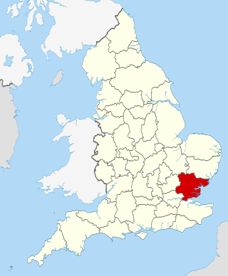
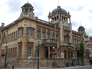
Essex is a ceremonial county in the East of England and one of the home counties. It is bordered by Cambridgeshire and Suffolk to the north, the North Sea to the east, Kent across the Thames Estuary to the south, Greater London to the south-west, and Hertfordshire to the west. The largest settlement is Southend-on-Sea, and the county town is Chelmsford.

References

  1. Baggs, A. P.; Board, Beryl; Crummy, Philip; et al. (1994). Cooper, Janet (ed.). A History of the County of Essex: Volume 9, the Borough of Colchester. London: Victoria County History. pp. 2–18. Retrieved 15 January 2018.
  2. Fawn, A.J., Evens, K.A., McMaster, I., Davies, G.M.R. (1990) 'The Red Hills of Essex; Salt making in Antiquity' Published by Colchester Archaeological Group. ( ISBN   0 9503905 1 8)
  3. Vision of Britain — Type details for ancient county. Retrieved 26 January 2009.

Further reading

Hidden Heritage – Discovering Ancient Essex, by Terry Johnson by Terry Johnson Whilst major sites such as Stonehenge and Avebury are well known, few people realise how rich in ancient sites are other areas of Britain. Terry first examines features of the landscape and unusual church carvings in general, then gives a detailed listing of interesting sites in Essex with associated legends and folklore, in addition to examining possible leys. ISBN   1898307 709