
Bolgatanga, colloquially known as Bolga, is a town and the capital of the Bolgatanga Municipality and Upper East Region of Ghana, adjacent to the border with Burkina Faso. Bolgatanga has over 2012 settlements and a population of about 66,685 people. Bolgatanga is 161 km to the north of Tamale. Bolgatanga lies in the Red Volta River Valley, with the White Volta River and the cliffs of the Gambaga Escarpment to the south of the town forming the southern boundary of the Upper East Region.

Bawku is a town and is the capital of the Bawku Municipal District, district in the Upper East region of north Ghana, adjacent to the border with Burkina Faso. It is located approximately between latitudes 11o 111 and 100 401 North and longitude 0o 181w and 0o 61 E in the north-eastern corner of the region. The municipality has a total land area of about 257 km2. The Municipality was established by Legislative Instrument (L.I) 2103. The municipality has a total land area of about 257 km2. Bawku has a 2021 settlement population of 119,458 people. Hon. Ayariga Mahama is the Member of Parliament for Bawku Central Constituency.

East Mamprusi Municipal Assembly is one of the six districts in North East Region, Ghana. Originally created as an ordinary district assembly in 1988 when it was known as East Mamprusi District, which was created from the former Mamprusi District Council, until the eastern part of the district was split off by a decree of president John Agyekum Kufuor on 19 August 2004 to create Bunkpurugu-Yunyoo District; thus the remaining part has been retained as East Mamprusi District. However on 15 March 2018, it was elevated to municipal district assembly status to become East Mamprusi Municipal District. The municipality is located in the eastern part of North East Region and has Gambaga as its capital town.
West Mamprusi Municipal Assembly is one of the six districts in North East Region, Ghana. Originally created as an ordinary district assembly in 1988 when it was known as West Mamprusi District, which was created from the former Mamprusi District Council, until the western part of the district was split off on 28 June 2012 to create Mamprugu-Moagduri District; thus the remaining part has been retained as West Mamprusi District. However, on 15 March 2018, it was elevated to municipal district assembly status to become West Mamprusi Municipal District. The municipality is located in the western part of North East Region and has Walewale as its capital town. Other settlements within the municipal assembly include Wulugu.

Gushegu Municipal District is one of the sixteen districts in Northern Region, Ghana. Originally it was formerly part of the then-larger Gushegu-Karaga District in 1988, which was created from the former East Dagomba District Council, until the western part of the district was split off to create Karaga District on 27 August 2004; thus the remaining part has been renamed as Gushegu District, which it was later elevated to municipal district assembly status on that same year to become Gushegu Municipal District. The municipality is located in the northeast part of Northern Region and has Gushegu as its capital town.
Karaga District is one of the sixteen districts in Northern Region, Ghana. Originally it was formerly part of the then-larger Gushegu-Karaga District in 1988, which was created from the former East Dagomba District Council, until the western part of the district was split off to create Karaga District on 27 August 2004; thus the remaining part has been renamed as Gushegu District, which it was later elevated to municipal district assembly status on that same year to become Gushegu Municipal District. The district assembly is located in the northeast part of Northern Region and has Karaga as its capital town.

Bawku Municipal District is one of the fifteen districts in Upper East Region, Ghana. Originally created as an ordinary district assembly in 1988 when it was known as Bawku East District; which was established by Legislative Instrument (L.I.) 1439, until the southern part of the district was split off by a decree of president John Agyekum Kufuor in August 2004 to create Garu-Tempane District; thus the remaining part was elevated to municipal district assembly status on the same year to become Bawku Municipal District. However, on 28 June 2012, two parts of the district were later split off to create Binduri District and Pusiga District respectively; thus the remaining part has been retained as Bawku Municipal District. The municipality is located in the eastern part of Upper East Region and has Bawku as its capital town.
Mamprusis are an ethnic group in northern Ghana and Togo. Estimates are that there are about 200,000 Mamprusis living in the Northern Regions of Ghana as of 2013. They speak Mampruli, one of the Gur languages. In Ghana, the Mamprusis live mainly in Nalerigu, Gambaga, Walewale, and their surrounding towns and villages in the North East Region. Their origin is in the Upper East Region, principally, Bawku, and they also inhabit parts of the Upper West Region, too.
Walewale is one of the constituencies represented in the Parliament of Ghana. It elects one Member of Parliament (MP) by the [first past the post] / Simple Majority] system of election. Walewale is located in the West Mamprusi Municipal of the North East Region of Ghana. It is the Municipal capital of West Mamprusi Municipal Assembly. The constituency was formerly called the West Mamprusi Constituency.
Nalerigu is the largest town in the East Mamprusi Municipal Assembly in the North East Region of Ghana as well as the traditional capital of the Mamprusi people, the seat of the Paramount chief, the NaYiri. Nalerigu is also the capital of the Northeast Region of Ghana. The Northeast Region, one of the six new regions established nationwide in 2018, has its administrative headquarters in Nalerigu.
The Mampruli language is a Gur language spoken in northern Ghana, Northern Togo, Burkina Faso, Ivory Coast and Mali by the Mamprusi people. It is partially mutually intelligible with Dagbani. The Mamprusi language is spoken in a broad belt across the northern parts of the Northern Region of Ghana, stretching west to east from Yizeesi to Nakpanduri and centred on the towns of Gambaga, Nalerigu and Walewale.

Walewale is a town and the capital of Mamprusi West Municipal in the North East Region of Ghana. The West Mamprusi Municipal is one of the 261 Metropolitan, Municipal, and District Assemblies (MMDAs) in Ghana, and forms part of the 6 MMDAs in the North East Region. The West Mamprusi Municipality is one of 45 new districts created in 1988 under the Government of Ghana’s decentralization and was later replaced with LI 2061 in 2012. With its administrative capital as Walewale.
Garu is a town and is the administrative capital of Garu District, a district in the Upper East Region of northern Ghana.

Gambaga Witch Camp is a segregated community within Gambaga township in the North East Region of Ghana established as a shelter to accommodate alleged witches and wizards who are banished from their communities.
Mamprugu-Moagduri District is one of the six districts in North East Region, Ghana. Originally it was formerly part of a then-larger West Mamprusi District in 1988, which was created from the former Mamprusi District Council, until the western part of the district was split off on 28 June 2012 to create Mamprugu-Moagduri District; thus the remaining part was still has been retained West Mamprusi District. The district assembly is located in the western part of North East Region and has Yagaba as its capital town.
Gambaga College of Education is a teacher education college in Gambaga established in 2013. The college is located in Northern Zone. It is one of the about 46 public colleges of education in Ghana. The college participated in the DFID-funded T-TEL programme. It is affiliated with the University of Development Studies.
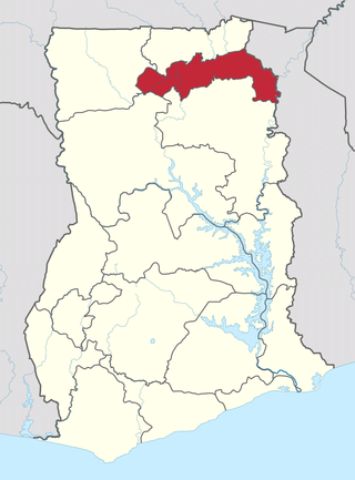
The North East Region is one of the sixteen regions of Ghana. It is located in the north of the country and was created in December 2018 after a referendum was voted upon to break it off of the Northern region. The region's capital is Nalerigu.
Bunkpurugu-Yunyoo District is a former district that was located in Northern Region, Ghana. Originally it was formerly part of the then-larger East Mamprusi District in 1988, which was created from the former Mamprusi District Council. However on 15 March 2018, it was split out into two new districts: Bunkpurugu-Nyankpanduri District and Yunyoo-Nasuan District. The district assembly was located in the north east part of Northern Region and had Bunkpurugu as its capital town. It is currently part of the North East region of Ghana.
Mamprusi District is a former district council that was located in North East Region, Ghana.
Bunkpurugu-Nyankpanduri District is one of the six districts in North East Region, Ghana. Originally it was formerly part of the then-larger Bunkpurugu-Yunyoo District on 19 August 2004, which was created from the former Mamprusi District Council, until the southern part of the district was split off to create Yunyoo-Nasuan District on 15 March 2018; thus the remaining part has been renamed as Bunkpurugu-Nyankpanduri District. The district assembly was located in the northeast part of Northern Region and had Bunkpurugu as its capital town.


