The Ming dynasty, officially the Great Ming, was an imperial dynasty of China, ruling from 1368 to 1644 following the collapse of the Mongol-led Yuan dynasty. The Ming dynasty was the last imperial dynasty of China ruled by the Han people, the majority ethnic group in China. Although the primary capital of Beijing fell in 1644 to a rebellion led by Li Zicheng, numerous rump regimes ruled by remnants of the Ming imperial family—collectively called the Southern Ming—survived until 1662.
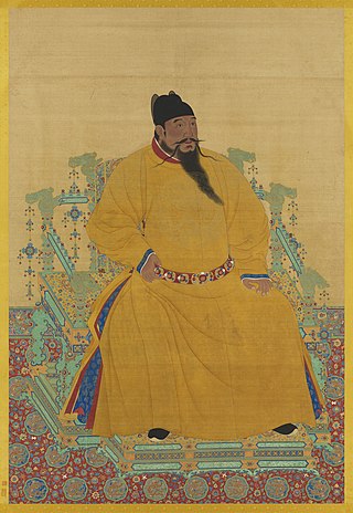
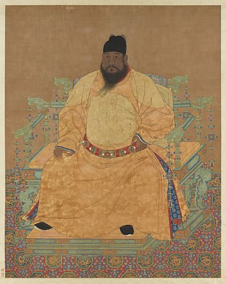
The Yongle Emperor, personal name Zhu Di, was the third Emperor of the Ming dynasty, reigning from 1402 to 1424. He was addressed as the "Emperor Manjushri" (文殊皇帝) by Tibetans.
Jurchen is a term used to collectively describe a number of East Asian Tungusic-speaking people, descended from the Donghu people. They lived in northeastern China, also known as Manchuria, before the 18th century. The Jurchens were renamed Manchus in 1635 by Hong Taiji. Different Jurchen groups lived as hunter-gatherers, pastoralist semi-nomads, or sedentary agriculturists. Generally lacking a central authority, and having little communication with each other, many Jurchen groups fell under the influence of neighbouring dynasties, their chiefs paying tribute and holding nominal posts as effectively hereditary commanders of border guards.
Hongwu was the era name of the Hongwu Emperor during his reign, and was also the Ming dynasty's first era name.

Neo-Confucianism is a moral, ethical, and metaphysical Chinese philosophy influenced by Confucianism, which originated with Han Yu (768–824) and Li Ao (772–841) in the Tang dynasty, and became prominent during the Song and Ming dynasties under the formulations of Zhu Xi (1130–1200). After the Mongol conquest of China in the thirteenth century, Chinese scholars and officials restored and preserved neo-Confucianism as a way to safeguard the cultural heritage of China.
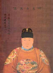
The Xuande Emperor, personal name Zhu Zhanji (朱瞻基), was the fifth Emperor of the Ming dynasty, reigned from 1425 to 1435. His era name "Xuande" means "proclamation of virtue". Ruling over a relatively peaceful period within Ming history, he was also personally fond of painting and literature. The Emperor ordered tax reductions on burdened farmers and attempted to purge corruption from the revenue collectors. His attempts to reform meritocracy within the military were unsuccessful, and he was forced to recognize the independence of Vietnam when the Mongol threat diverted his attention.

Biligtü Khan or the Emperor Zhaozong of Northern Yuan, born Ayushiridara, was an emperor of the Northern Yuan dynasty, reigning from 1370 to 1378. He ascended to the throne after the death of his father who was the last Yuan emperor. In 1372, he defeated an invading Ming army and recaptured some regions that were previously lost to the newly founded Ming dynasty.
The Jianwen Emperor, personal name Zhu Yunwen (朱允炆), was the second Emperor of the Ming dynasty, reigned from 1398 to 1402. The era name of his reign, "Jianwen", means "establishing civility" and represented a sharp change in tone from Hongwu, the era name of the reign of his grandfather and predecessor, the Hongwu Emperor. His reign did not last long: an attempt to restrain his uncles led to the Jingnan rebellion. The Jianwen Emperor was eventually overthrown by one of his uncles, Zhu Di, who was then enthroned as the Yongle Emperor. Although the Yongle Emperor presented a charred body as Zhu Yunwen's, rumours circulated for decades that the Jianwen Emperor had disguised himself as a Buddhist monk and escaped from the palace when it was set on fire by Zhu Di's forces. The History of Ming mentioned that one of the reasons behind why the Yongle Emperor sponsored the admiral Zheng He on his treasure voyages in the early 15th century was for Zheng He to search for the Jianwen Emperor, who was believed to have survived and fled to Southeast Asia.

The Gujin Tushu Jicheng, also known as the Imperial Encyclopaedia, is a vast encyclopedic work written in China during the reigns of the Qing dynasty emperors Kangxi and Yongzheng. It was begun in 1700 and completed in 1725. The work was headed and compiled mainly by scholar Chen Menglei (陳夢雷). Later on Jiang Tingxi helped work on it as well.
Taizong is the temple name used for several monarchs of China. It may refer to:
The earliest known world maps date to classical antiquity, the oldest examples of the 6th to 5th centuries BCE still based on the flat Earth paradigm. World maps assuming a spherical Earth first appear in the Hellenistic period. The developments of Greek geography during this time, notably by Eratosthenes and Posidonius culminated in the Roman era, with Ptolemy's world map, which would remain authoritative throughout the Middle Ages. Since Ptolemy, knowledge of the approximate size of the Earth allowed cartographers to estimate the extent of their geographical knowledge, and to indicate parts of the planet known to exist but not yet explored as terra incognita.

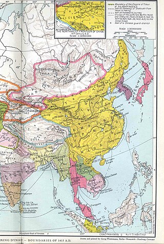
The Ming dynasty, officially the Great Ming, founded by the peasant rebel leader Zhu Yuanzhang, known as the Hongwu Emperor, was an imperial dynasty of China. It was the successor to the Yuan dynasty and the predecessor of the short-lived Shun dynasty, which was in turn succeeded by the Qing dynasty. At its height, the Ming dynasty had a population of 160 million people, while some assert the population could actually have been as large as 200 million.

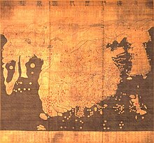
The Da Ming Hunyi Tu is an extensive Chinese map. It was painted in colour on stiff silk and 386 x 456 cm in size. The original text was written in Classical Chinese, but on the surviving copy Manchu labels were later superimposed. The surviving copy of the map shows later revisions, and it is uncertain whether it is the original.
Chinese cartography began in the 5th century BC during the Warring States period when cartographers started to make maps of the Earth's surface. Its scope extended beyond China's borders with the expansion of the Chinese Empire under the Han dynasty. By the 11th century during the Song dynasty highly-accurate maps drawn on grids were produced. During the 15th century, the Ming dynasty admiral Zheng He went on a series of voyages to the South China Sea, Indian Ocean, and beyond and maps for areas outside of China were produced, although world maps covering territories known to the Chinese outside of China existed as early as the Tang dynasty.
Kunyu Wanguo Quantu, printed in Ming China at the request of the Wanli Emperor in 1602 by the Italian Catholic missionary Matteo Ricci and Chinese collaborators, the mandarin Zhong Wentao, and the technical translator Li Zhizao, is the earliest known Chinese world map with the style of European maps. It has been referred to as the Impossible Black Tulip of Cartography, "because of its rarity, importance and exoticism". The map was crucial in expanding Chinese knowledge of the world. It was eventually exported to Korea then Japan and was influential there as well, though less so than Giulio Aleni's Zhifang Waiji.

Luo Hongxian was a Ming dynasty Chinese cartographer. He also studied astronomy, geography, irrigation methods, military affairs and mathematics.

The Hua Yi Tu is a map engraved as a stone stele dated from 1136, around the time of the Song dynasty. It is the earliest surviving map that displays maritime connections between China and other foreign states. The stele is now in the Stele Forest or Beilin Museum in Xi'an, China.

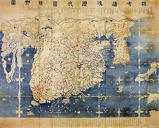
Ryūsen-zu 流宣図 is a style of woodblock print maps created by the ukiyo-e artist and popular writer Ishikawa Ryūsen (jp) in the Edo period in Japan.

The debate on the "Chineseness" of the Yuan and Qing dynasties is concerned with whether the Mongol-led Yuan dynasty (1271–1368) and the Manchu-led Qing dynasty (1636–1912) can be considered "Chinese dynasties", and whether they were representative of "China" during the respective historical periods. The debate, albeit historiographical in nature, has political implications. Mainstream academia and successive governments of China, including the imperial governments of the Yuan and Qing dynasties, have maintained the view that they were "Chinese" and representative of "China". In short, the cause of the controversy stems from the dispute in interpreting the relationship between the two concepts of "Han Chinese" and "China", because although the Chinese government recognizes 56 ethnic groups in China and the Han have a more open view of the Yuan and Qing dynasties since Liang Qichao and other royalist reformers supported the Qing dynasty, the Han are China's main ethnic group. This means that there are many opinions that equate Han Chinese people with China and lead to criticism of the legitimacy of these two dynasties.