Geddes Dam

Last updated

Geddes Dam
Geddes Dam (Michigan).jpg
North section of Geddes Dam in April 2020
Relief map of USA Michigan.png
Red pog.svg
Location within the state of Michigan
Location Huron River
Ann Arbor Township, Michigan
Coordinates 42°16′15″N83°40′17″W / 42.27092°N 83.67142°W / 42.27092; -83.67142
Purpose Power
StatusDecommissioned
Opening date1919;105 years ago (1919)
Owner(s) City of Ann Arbor
Dam and spillways
Type of dam Barrage
Impounds Huron River
Height28 feet (8.5 m)
Length87 feet (26.5 m)
Width (crest)150 feet (45.7 m)
Spillway capacity9,700 ft3/s (275 m3/s)
Reservoir
Total capacity261 acres (105.6 ha)

The Geddes Dam is a decommissioned hydroelectric barrage dam crossing the Huron River. It is located in Ann Arbor Township in Washtenaw County in the U.S. state of Michigan. It was built by the Detroit Edison Company in 1919 for hydroelectricity before being decommissioned in 1959. The dam is currently owned by the nearby city of Ann Arbor. The surrounding area is used for recreational purposes, including Gallup Park, which is Ann Arbor's most popular recreational area. [1] [2]

Contents

Description

The Geddes Dam is located in southeastern Ann Arbor Township about 0.25 miles (0.40 km) from the eastern city limits of Ann Arbor. U.S. Route 23 crosses the river slightly west of the dam, which forms the eastern boundary of Ann Arbor's city limits at this point. The Geddes Dam is approximately 45.5 miles (73.2 km) from the Huron River mouth at Lake Erie. The nearest dams are the Argo Dam 5.0 miles (8.0 km) upstream and the Superior Dam 2.5 miles (4.0 km) downstream. When the dam was completed, the resulting flooding created a reservoir of 261 acres (106 ha). [3] The reservoir has no official name but is sometimes referred to as the Geddes Pond or Geddes Impoundment. It sits at an elevation of 747 feet (228 m) above sea level and has an average depth of 16.3 feet (5.0 m). The dam has a discharge capacity of 9,700 cubic feet per second (275 m3/s). [1] [4]

The dam consists of two automated bays, each with two concrete spillways for a total dam length of 87 feet (26.5 m) and an entire crest length of 150 feet (45.7 m). The dam is 28 feet (8.5 m) tall. [1]  

The dam is one of four dams owned by the city of Ann Arbor. The other dams are the Argo Dam, Barton Dam, and Superior Dam. Only the Argo Dam and Barton Dam are actually within the city of Ann Arbor. Geddes Dam is within Ann Arbor Township, and Superior Dam is in neighboring Superior Township to the east. [5] [6]

History

The first hydroelectric facility was built along this stretch of the Huron River in 1884. [4] Property along the Huron River was purchased by the Detroit Edison Company in 1905 for the purpose of building a hydroelectric dam. [7]

The dam was eventually built in 1919 as a series of hydroelectric dams built along the Huron River. The Geddes Dam was decommissioned in 1959 and no longer utilized for hydroelectric purposes. The dam was sold to the city of Ann Arbor in 1963. In 1968, the "heaviest storm in a generation" caused the Geddes Dam to fail, and increased water levels also severely damaged several downstream dams and caused considerable property damage. [8] The dam was rebuilt in 1971–1972, in which new automated gates were installed to control the water level of the reservoir. [9]

The Detroit Edison Company once operated four hydroelectric dams that served Ann Arbor: Argo Dam, Barton Dam, Geddes Dam, and Superior Dam. At one time, they were all decommissioned in the late-1950s, but Barton Dam and Superior Dam were recommissioned in the 1980s and currently provide hydroelectricity for Ann Arbor's power grid. Geddes Dam and Argo Dam were left decommissioned, because higher cost estimates and lower energy production kept them from being recommended for recommissioning. [10]

In 2010, a plan was proposed by the U.S. Army Corps of Engineers to recommission the Argo and Geddes Dam in order to provide additional electric power to the nearby Ann Arbor VA Medical Center. A study found it would cost up to $14.7 million to construct new hydroelectric stations at both decommissioned dams. The transmission lines themselves would cost another $1.3 million, with at least $220,000 per year for maintenance. Funding was denied by the Ann Arbor City Council to go ahead with the project, but the proposal of completely removing the Geddes Dam was also not in financial consideration. [1] [11] In 2013, the city approved a financial plan to improve the surrounded areas of both Argo Dam and Geddes Dam at a cost of $295,530 to a local contractor. [12] The dams received these significant improvements in 2014. [1]

Activities

Reservoir side of the Geddes Dam Geddes Dam (Michigan)2.jpg
Reservoir side of the Geddes Dam

The Geddes Dam serves a recreational purposes for shore fishing in both the reservoir and the area immediately downstream along the Huron River. Common fish caught within this area include catfish (bullhead and channel), bluegill, small and largemouth bass, black crappie, northern pike, and walleye. [3] At one time, tiger muskellunge were stocked by the Michigan Department of Natural Resources at the Geddes Dam reservoir, but the population did not materialize and was not replenished. [4]

The Border-to-Border Trail, which runs for 35 miles (56.3 km) from Dexter Township to Ypsilanti Township, passes along the Geddes Dam and also provides public amenities. [13] The area along the western edge of the reservoir is organized as Gallup Park, which is Ann Arbor's most popular recreation area. Gallup Park is located on both sides of the reservoir about 1 mile (1.61 km) upstream. [2] The Michigan Department of Natural Resources maintains a small public boat launch at Gallup Park, which allows for access to the reservoir and Geddes Dam. [14] Larger boats are restricted, as the reservoir is a no-wake zone, and canoes and kayaks that want to continue the path of the Huron River must portage over the dam.

Health concerns

The Huron River is occasionally issued a "Do Not Eat" fish advisory by the Michigan Department of Health and Human Services when the waters accumulate high levels of cyanobacteria and perfluorooctanesulfonatecan (PFOS). When this bacteria is present, prolonged contact with the water is not advised, although occasional contact with PFOS is not considered a health concern. [15] When the advisory is in place, fishermen are advised to catch and release only, and warning signs are posted at river access points. The advisory is often issued for long stretches of the Huron River that include the Geddes Dam portion of the river. [16] [17]

Related Research Articles

<span class="mw-page-title-main">Ann Arbor, Michigan</span> City in Michigan, United States

Ann Arbor is a city in and the county seat of Washtenaw County, Michigan, United States. The 2020 census recorded its population to be 123,851, making it the fifth-most populous city in Michigan. It is the principal city of the Ann Arbor metropolitan area, which encompasses all of Washtenaw County and had 372,258 residents in 2020. Ann Arbor is also included in the Metro Detroit combined statistical area and the Great Lakes megalopolis.

<span class="mw-page-title-main">Au Sable River (Michigan)</span> River in Michigan, United States

The Au Sable River is a 138-mile-long (222 km) river in the Lower Peninsula of the U.S. state of Michigan. Rising in the Northern Lower Peninsula, the river flows in a generally southeasterly direction to its mouth at Lake Huron at the communities of Au Sable and Oscoda.It is considered one of the best brown trout fisheries east of the Rockies and has been designated a blue ribbon trout stream by the Michigan Department of Natural Resources. A map from 1795 located in the United States Gazetteer calls it the Beauais River. In French, the river is called the Rivière au sable, literally "Sand River".

<span class="mw-page-title-main">Washtenaw County, Michigan</span> County in Michigan, United States

Washtenaw County is a county located in the U.S. state of Michigan. At the 2020 census, the population was 372,258. The county seat and largest city is Ann Arbor. The county was authorized by legislation in 1822 and organized as a county in 1826. Washtenaw County comprises the Ann Arbor Metropolitan Statistical Area. The county is home to the University of Michigan, Eastern Michigan University, Washtenaw Community College, and Concordia University Ann Arbor.

<span class="mw-page-title-main">Ann Arbor Charter Township, Michigan</span> Charter township in Michigan, United States

Ann Arbor Charter Township is a charter township of Washtenaw County in the U.S. state of Michigan. The population was 4,673 at the 2020 census. The township borders the city of Ann Arbor and contains numerous exclaves, but the two are administered autonomously.

<span class="mw-page-title-main">Barton Hills, Michigan</span> Village in Michigan, United States

Barton Hills is a village in Washtenaw County in the U.S. state of Michigan. The population was 316 at the 2020 census. The village is located within Ann Arbor Charter Township just northwest of the city of Ann Arbor.

<span class="mw-page-title-main">Grand River (Michigan)</span> Tributary of Lake Michigan in southern Michigan

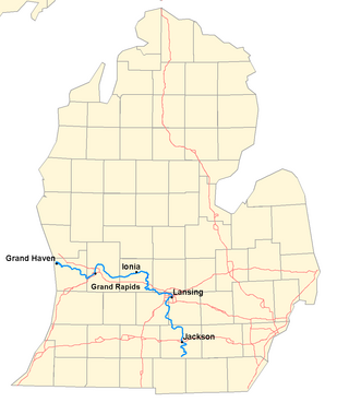
The Grand River is a 252-mile-long (406 km) river in the Lower Peninsula of the U.S. state of Michigan. The longest river in Michigan, the Grand River rises in Hillsdale County, and flows in a generally northwesterly direction to its mouth at Lake Michigan in the city of Grand Haven. The river flows through a number of cities, including Jackson, Lansing, Ionia, and Grand Rapids.

<span class="mw-page-title-main">Huron River</span> River in Michigan, United States

The Huron River is a 130-mile-long (210 km) river in southeastern Michigan, rising out of the Huron Swamp in Springfield Township in northern Oakland County and flowing into Lake Erie, as it forms the boundary between present-day Wayne and Monroe counties. Thirteen parks, game areas, and recreation areas are associated with the river, which passes through the cities of Dexter, Ann Arbor, Ypsilanti, Belleville, Flat Rock and Rockwood that were developed along its banks.

<span class="mw-page-title-main">Flint River (Michigan)</span> River in central Michigan, United States

The Flint River is a 78.3-mile-long (126.0 km) river in the Flint/Tri-Cities region of Michigan in the United States. The river's headwaters are in Columbiaville in Lapeer County and flows through the counties of Lapeer, Genesee, and Saginaw. The cities of Lapeer, Flint, Flushing, and Montrose are along its course.

<span class="mw-page-title-main">Belleville Lake</span>

Belleville Lake is a fresh water artificial reservoir located mostly within Wayne County in the U.S. state of Michigan. A very small portion extends west into Washtenaw County. The lake was created from the construction of the French Landing Dam and Powerhouse along the Huron River in 1925.

<span class="mw-page-title-main">Pointe Mouillee State Game Area</span> Protected area in Michigan, U.S.

Pointe Mouillee State Game Area is a state game area in the U.S. state of Michigan. It encompasses 7,483 acres (30.3 km2) of hunting, recreational, and protected wildlife and wetland areas at the mouth of the Huron River at Lake Erie, as well as smaller outlying areas within the Detroit River. Pointe Mouillee State Game Area was established in 1945 and is administered by the Michigan Department of Natural Resources.

<span class="mw-page-title-main">County Road 510 (Marquette County, Michigan)</span> County road in Marquette County, Michigan, United States

County Road 510 is a primary county road in Marquette County, Michigan, that connects Negaunee Township with the community of Big Bay. The road runs through rural forests as a paved and dirt road in northern Marquette County. It crosses the Dead River near the Hoist and McClure dams and runs for 26.103 miles (42.009 km) before terminating at an intersection with CR 550 south of Big Bay.

<span class="mw-page-title-main">Kent Lake (Michigan)</span> Reservoir in Oakland and Livingston County, Michigan

Kent Lake is a 1,200-acre (490 ha) reservoir lake formed by damming the Huron River near its headwaters. Kent Lake is mostly located in Oakland County, Michigan in Milford and Lyon Townships, with a small portion including its dam located in Green Oak Township, Livingston County, Michigan.

<span class="mw-page-title-main">French Landing Dam and Powerhouse</span> Dam in Wayne County, Michigan

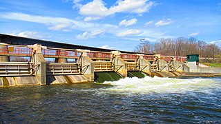
The French Landing Dam and Powerhouse is a hydroelectric gravity dam and powerhouse crossing the Huron River in Van Buren Charter Township in Wayne County in the state of Michigan. The dam and the powerhouse were completed in 1925 by the Detroit Edison Company on land previously purchased in 1910. The dam and powerhouse were designated as a Michigan State Historic Site on February 18, 1982.

<span class="mw-page-title-main">Ford Lake (Michigan)</span> Fresh water Reservoir in Washtenaw County, Michigan

Ford Lake is a fresh water artificial reservoir located in Washtenaw County in the U.S. state of Michigan. The lake was created from the construction of Ford Lake Dam along the Huron River in the early 1930s. The lake is named after business magnate Henry Ford.

<span class="mw-page-title-main">Flat Rock Dam (Michigan)</span> Dam in Flat Rock, Michigan

The Flat Rock Dam is a decommissioned hydroelectric gravity dam crossing the Huron River. It is located in the city of Flat Rock in Wayne County in the U.S. state of Michigan. The dam was built by the Ford Motor Company in 1924 for hydroelectricity for the nearby Ford Motor Company Lamp Factory, which remained in operation until 1950.

<span class="mw-page-title-main">Superior Dam</span> Dam in Superior Township, Michigan

The Superior Dam is a hydroelectric barrage dam crossing the Huron River. It is located in Superior Township in Washtenaw County in the U.S. state of Michigan. It was completed in 1920 and currently provides hydroelectricity to the nearby city of Ann Arbor, which owns and maintains the dam and power station.

<span class="mw-page-title-main">Argo Dam</span> Dam in Ann Arbor, Michigan

The Argo Dam is a decommissioned hydroelectric barrage dam crossing the Huron River. It is located in the city of Ann Arbor in Washtenaw County in the U.S. state of Michigan. It was built by the Detroit Edison Company in 1920 for hydroelectricity before being decommissioned in 1959 and sold to the city of Ann Arbor in 1963. The surrounding area is used for recreational purposes, including Argo Nature Area and Bandemer Park.

<span class="mw-page-title-main">Barton Dam</span> Dam in Ann Arbor, Michigan

The Barton Dam is a hydroelectric barrage dam crossing the Huron River. It is located in the city of Ann Arbor in Washtenaw County in the U.S. state of Michigan. It began operating in 1912 and currently provides hydroelectricity to city of Ann Arbor, which owns and maintains the dam and power station.

<span class="mw-page-title-main">Gallup Park</span>

Gallup Park is a park on the Huron River in Ann Arbor, Michigan. Gallup Park is the busiest park in the Ann Arbor parks system, and features multiple amenities including a canoe livery, universal-access playgrounds, and a public boat launch. The park's pathways form a major component of the Border-to-Border Trail, a multi-use trail that spans Washtenaw County.

References

  1. 1 2 3 4 5 Huron River Watershed Council (November 2015). "Geddes Dam" (PDF). Retrieved April 20, 2020.
  2. 1 2 Parks and Recreation (2020). "Gallup Park". City of Ann Arbor . Retrieved May 19, 2020.
  3. 1 2 Michigan Department of Natural Resources (2020). "Huron River-Gallup Park/Geddes Pond". Michigan Department of Natural Resources. Retrieved May 22, 2020.
  4. 1 2 3 Fisheries Division (April 1995). "– Special Report: Huron River Assessment" (PDF). Michigan Department of Natural Resources. Retrieved May 22, 2020.
  5. "Ann Arbor officials get Argo Dam issue soon". MLive. Booth Newspapers. April 4, 2019. Retrieved April 20, 2020.
  6. City of Ann Arbor (2020). "Dams and Hydros". City of Ann Arbor. Retrieved April 20, 2020.
  7. Detroit Historical Society (2020). "Photo Record: Geddes". Detroit Historical Society. Retrieved May 21, 2020.
  8. "Return to the River: Gallup Park opened up a "private river." Now a new playground is making it even more accessible". Ann Arbor Observer. August 2017. Retrieved May 23, 2020.
  9. Ann Arbor District Library (2020). "Checking Dam Operation Is No Baffling Task For Him". Ann Arbor District Library. Retrieved May 20, 2020.
  10. Huron River Watershed Council (September 27, 2010). "Argo & Geddes Dams, Ann Arbor Hyrdopower Study Final Report" (PDF). Huron River Watershed Council. Retrieved May 24, 2020.
  11. "Feds considering installing hydropower stations at Argo and Geddes dams in Ann Arbor". The Ann Arbor News . November 15, 2010. Retrieved May 23, 2020.
  12. "Deliberations on DDA Pave Way for Final Vote". The Ann Arbor Chronicle. April 10, 2013. Retrieved May 23, 2020.
  13. Huron River National Water Trail (Ann Arbor) (2020). "Border-to-Border Trail Access" (PDF). Huron River National Water Trail (Ann Arbor). Retrieved May 24, 2020.
  14. Michigan Department of Natural Resources (2019). "Michigan Recreational Boating Information System (MRBIS): Boating Access Site Detail (Gallup Park)". Michigan Department of Natural Resources. Retrieved April 2, 2019.
  15. City of Ann Arbor (August 31, 2018). "Michigan extends 'Do Not Eat' Fish Advisory for Huron River to Lake Erie" (Press release). City of Ann Arbor. Retrieved August 24, 2019.
  16. Hicks, Mark (September 1, 2018). "State: Don't eat Huron River fish in 5 counties". The Detroit News . Retrieved August 22, 2019.
  17. "Huron River 'do not eat' advisory extended". Monroe News. March 13, 2019. Retrieved April 10, 2020.