Superior Dam

Last updated

Superior Dam
Superior Dam (Michigan).jpg
Superior Dam in April 2020
Relief map of USA Michigan.png
Red pog.svg
Location within the state of Michigan
Location Huron River
Superior Township, Michigan
Coordinates 42°15′56″N83°38′40″W / 42.26545°N 83.64452°W / 42.26545; -83.64452
Purpose Power
StatusOperational
Opening date1920;104 years ago (1920)
Owner(s) City of Ann Arbor
Dam and spillways
Type of dam Barrage
Impounds Huron River
Height27.5 feet (8.4 m)
Length160 feet (48.8 m)
Width (crest)330 feet (100.6 m)
Spillway capacity17,200 ft3/s (487 m3/s)
Reservoir
Total capacity93 acres (37.6 ha)

The Superior Dam is a hydroelectric barrage dam crossing the Huron River. It is located in Superior Township in Washtenaw County in the U.S. state of Michigan. It was completed in 1920 and currently provides hydroelectricity to the nearby city of Ann Arbor, which owns and maintains the dam and power station. [1]

Contents

Description

The Superior Dam is located in southwestern Superior Township about 1.5 miles (2.4 km) from the city of Ann Arbor. The Superior Dam is approximately 43 miles (69 km) from the Huron River mouth at Lake Erie. The Geddes Dam is 2.5 miles (4.0 km) upstream, and the Peninsular Paper Dam is 1.5 miles (2.4 km) downstream. When the dam was completed, the resulting flooding created a reservoir of 93 acres (38 ha). The reservoir has no official name but is sometimes referred to as the Superior Pond or Superior Impoundment. It sits at an elevation of 730 feet (220 m) above sea level and has an average depth of 22.4 feet (6.8 m). [2] The river narrows at this point, and the dam has a discharge capacity of 17,200 cubic feet per second (487 m3/s). [1]

The reservoir and the downstream portion of the dam are open to the public, but there are no developed pathways or roads leading to the river at this point. Foot paths are cut through the woods leading to the west side of the river and the dam. The east side of the dam contains the hydroelectric plant and is not accessible to the public at any point. The crosswalk over the dam is also restricted.

The dam is one of four dams owned by the city of Ann Arbor. The other dams are the Geddes Dam, Argo Dam, and Barton Dam. Only Argo Dam and Barton Dam are actually within the city of Ann Arbor. Geddes Dam is within Ann Arbor Township. [3] [4]

Hydroelectricity

The Superior Station Hydroelectric Plant was constructed alongside the dam in 1920. The facility was built by the Detroit Edison Company. The generating station only provides a very small portion of Ann Arbor's energy supply. In 1957, the four plants supplied 38  GWh of electricity, just under 6% of the city's energy usage for the year. Most other energy sources came from near Detroit. [5] The Detroit Edison Company decommissioned the site in 1963 and sold it to the city of Ann Arbor. The city restored the facility and put it back into service in 1986. Soon after, the city entered into a 50-year contract to sell the energy back to the Detroit Edison Company to supply electricity for Ann Arbor's power grid. [3]

Today, only the Superior Dam and Barton Dam have active hydroelectric facilities serving Ann Arbor. Combined, the two dams produce 6,000 MWh of electricity annually. [3] There are currently four active hydroelectric dams along the Huron River: Barton, Superior, Ford Lake, and French Landing. [2]

In a report published by the Huron River Watershed Council in 2019, they noted that the dam "does not generate enough electricity to cover its own annual maintenance and operating costs." Studies are being conducted on the feasibility of removing the dam—a fate that has already been determined for the decommissioned Peninsular Paper Dam 1.5 miles (2.4 km) downstream. [6] [7]

Activities

The Superior Dam reservoir Superior Dam (Michigan)2.jpg
The Superior Dam reservoir

The area surrounding the Superior Dam is mostly undeveloped. It is a located along the Huron River Water Trail, mapped by the Huron–Clinton Metroparks system to provide information for canoes and kayaks. [8] The Superior Dam does not have its own parking lot, park facilities, or launch, and carrying a canoe or kayak to the site is impractical. For boaters travelling down the Huron River, there is a small dock and portage, as well as improved terrain to allow portaging the dam and continuing along the river. [9] [10]

The city of Ann Arbor owns the dam and the surrounding area, but the city sees little demand for converting the area into a recreational facility on par with other riverfront parks. While the city owns the dam and reservoir, most of the land surrounding it is privately-owned Superior Township property. The area is remote and has no road access. The rowing conditions along the river at this point are not good enough to draw in large numbers of boaters, especially with very low bridge clearances and a lack of public amenities. [11]

The Superior Dam and its reservoir are accessible for shore fisherman. Common fish caught along this stretch of the river include small and largemouth bass, sunfish, rock bass, northern pike, crappie, and carp. [11]

Health concerns

The Huron River is occasionally issued a "do not eat" fish advisory by the Michigan Department of Health and Human Services when the waters accumulate high levels of cyanobacteria and perfluorooctanesulfonatecan (PFOS). When this bacteria is present, prolonged contact with the water is not advised, although occasional contact with PFOS is not considered a health concern. [12] When the advisory is in place, fishermen are advised to catch and release only, and warning signs are posted at river access points. While the Superior Dam and its reservoir are not specifically mentioned, the advisory is often issued for long stretches of the Huron River that include the Superior Dam portion of the river. [13] [14]

Related Research Articles

<span class="mw-page-title-main">Ann Arbor Charter Township, Michigan</span> Charter township in Michigan, United States

Ann Arbor Charter Township is a charter township of Washtenaw County in the U.S. state of Michigan. The population was 4,673 at the 2020 census. The township borders the city of Ann Arbor and contains numerous exclaves, but the two are administered autonomously.

<span class="mw-page-title-main">Barton Hills, Michigan</span> Village in Michigan, United States

Barton Hills is a village in Washtenaw County in the U.S. state of Michigan. The population was 316 at the 2020 census. The village is located within Ann Arbor Charter Township just northwest of the city of Ann Arbor.

<span class="mw-page-title-main">Huron River</span> River in Michigan, United States

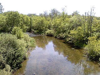
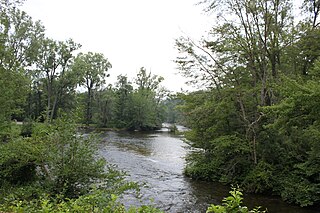
The Huron River is a 130-mile-long (210 km) river in southeastern Michigan, rising out of the Huron Swamp in Springfield Township in northern Oakland County and flowing into Lake Erie, as it forms the boundary between present-day Wayne and Monroe counties. Thirteen parks, game areas, and recreation areas are associated with the river, which passes through the cities of Dexter, Ann Arbor, Ypsilanti, Belleville, Flat Rock and Rockwood that were developed along its banks.

<span class="mw-page-title-main">Clinton River (Michigan)</span> River in Michigan, United States

The Clinton River is a river in southeastern Michigan in the United States. It is named in honor of DeWitt Clinton, who was governor of New York from 1817 to 1823.

<span class="mw-page-title-main">Huron–Clinton Metroparks</span> A regional park system around Detroit, Michigan

The Huron–Clinton Metroparks system is a regional park system in Metro Detroit in the U.S. state of Michigan. The park system includes 13 parks totaling more than 24,000 acres (97 km2) arranged along the Huron River and Clinton River forming a partial ring around the metro area. Plans are in development to finish the ring by building hike/bike trails to connect all the parks as a green belt. The parks draw about 7.5 million visitors a year, down from a peak of 10 million in 2009. The park system is primarily tax-funded with a $50 million annual budget. The system provides employment for 200 full-time and part-time employees year-round and 1,000 additional summer workers. The rivers are prime fishing and canoeing streams with Delhi Metropark including a short rapids, which while runnable, is the only point other than dams on either stream normally portaged.

Stony Creek Metropark is a Huron-Clinton Metropark located in southeast Michigan in the outskirts of metro Detroit. The park is predominantly in Washington Township and Oakland Township, with a small portion in Shelby Township. The park covers 4,461 acres (18.05 km2) with Stony Creek Lake at its center.

<span class="mw-page-title-main">Belleville Lake</span>

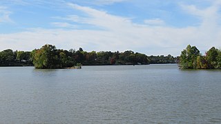
Belleville Lake is a fresh water artificial reservoir located mostly within Wayne County in the U.S. state of Michigan. A very small portion extends west into Washtenaw County. The lake was created from the construction of the French Landing Dam and Powerhouse along the Huron River in 1925.

<span class="mw-page-title-main">Hudson Mills Metropark</span> Park in Washtenaw County, Michigan, United States

Hudson Mills Metropark is a park in the Huron-Clinton system of metro parks in Michigan, USA. It is located on North Territorial Road at the crossing of the Huron River, twelve miles (19 km) northwest of Ann Arbor. The park covers 1,549 acres and has an 18-hole golf course, disc golf courses, picnic areas, swings and slides, softball diamonds, a hike-bike trail, nature trails, river fishing, a canoe camp and a group camp. The park is a popular destination for canoeing and kayaking; parking areas near the Huron River provide access for canoe launching. The park will eventually be linked to Dexter-Huron Metropark and Delhi Metropark via the Border-to-Border Trail. Canoe rentals are available at Delhi Metropark.

<span class="mw-page-title-main">Oakwoods Metropark</span>

Oakwoods Metropark is a park in the Huron-Clinton Metroparks system, located along the Huron River near Flat Rock, Michigan. The park consists several miles of bike trails, numerous nature trails, horse trails, a canoe and kayak launch, and a Nature Center. It is directly connected to Willow and Lower Huron Metroparks, as well as Huroc Park through a branch of the Downriver Linked Greenways.

<span class="mw-page-title-main">Willow Metropark</span>

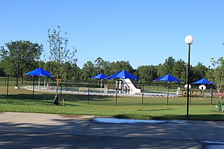
Willow Metropark is a park in the Huron-Clinton Metroparks system, located on the banks of the Huron River between Lower Huron Metropark to the northwest and Oakwoods Metropark to the southeast. The park consists of a wide variety of trails and recreational areas, including an 18-hole golf course, the 17-acre (69,000 m2) Washago Pond, hike/bike trails, a disc golf course,a children's play area, a pool, and a kayak/canoe launch, in addition to groomed cross country ski trails in the winter months.

<span class="mw-page-title-main">Dexter–Huron Metropark</span> Park in Washtenaw County, Michigan, United States

Dexter–Huron Metropark is a 122-acre (0.49 km2) park on the Huron River in the Huron-Clinton system of metro parks. The park has three picnic areas, a children's play area, a softball diamond, fishing, and canoe launching. A Metropark daily or annual vehicle permit is required for entry. The park will eventually be linked to Hudson Mills Metropark and Delhi Metropark via the Border-to-Border Trail.

<span class="mw-page-title-main">Kent Lake (Michigan)</span> Reservoir in Oakland and Livingston County, Michigan

Kent Lake is a 1,200-acre (490 ha) reservoir lake formed by damming the Huron River near its headwaters. Kent Lake is mostly located in Oakland County, Michigan in Milford and Lyon Townships, with a small portion including its dam located in Green Oak Township, Livingston County, Michigan.

<span class="mw-page-title-main">Peninsular Paper Dam</span> Dam in Washtenaw County, Michigan

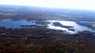
The Peninsular Paper Dam is a decommissioned hydroelectric concrete gravity dam and former paper mill and power station crossing the Huron River. It is located in the city of Ypsilanti in Washtenaw County in the U.S. state of Michigan. The dam was constructed in 1914, and the resulting reservoir is an unnamed 177-acre pond along the river.

<span class="mw-page-title-main">Ford Lake (Michigan)</span> Fresh water Reservoir in Washtenaw County, Michigan

Ford Lake is a fresh water artificial reservoir located in Washtenaw County in the U.S. state of Michigan. The lake was created from the construction of Ford Lake Dam along the Huron River in the early 1930s. The lake is named after business magnate Henry Ford.

<span class="mw-page-title-main">Ford Lake Dam</span> Dam in Washtenaw County, Michigan

The Ford Lake Dam is an earthen, multi-arch hydroelectric gravity dam and powerhouse crossing the Huron River in Ypsilanti Charter Township in Washtenaw County in the U.S. state of Michigan. The dam was constructed in 1931–1932 and created the Ford Lake reservoir at 975 acres (395 ha).

<span class="mw-page-title-main">Flat Rock Dam (Michigan)</span> Dam in Flat Rock, Michigan

The Flat Rock Dam is a decommissioned hydroelectric gravity dam crossing the Huron River. It is located in the city of Flat Rock in Wayne County in the U.S. state of Michigan. The dam was built by the Ford Motor Company in 1924 for hydroelectricity for the nearby Ford Motor Company Lamp Factory, which remained in operation until 1950.

<span class="mw-page-title-main">Geddes Dam</span> Dam in Ann Arbor Township, Michigan

The Geddes Dam is a decommissioned hydroelectric barrage dam crossing the Huron River. It is located in Ann Arbor Township in Washtenaw County in the U.S. state of Michigan. It was built by the Detroit Edison Company in 1919 for hydroelectricity before being decommissioned in 1959. The dam is currently owned by the nearby city of Ann Arbor. The surrounding area is used for recreational purposes, including Gallup Park, which is Ann Arbor's most popular recreational area.

<span class="mw-page-title-main">Argo Dam</span> Dam in Ann Arbor, Michigan

The Argo Dam is a decommissioned hydroelectric barrage dam crossing the Huron River. It is located in the city of Ann Arbor in Washtenaw County in the U.S. state of Michigan. It was built by the Detroit Edison Company in 1920 for hydroelectricity before being decommissioned in 1959 and sold to the city of Ann Arbor in 1963. The surrounding area is used for recreational purposes, including Argo Nature Area and Bandemer Park.

<span class="mw-page-title-main">Barton Dam</span> Dam in Ann Arbor, Michigan

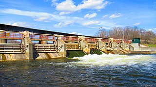
The Barton Dam is a hydroelectric barrage dam crossing the Huron River. It is located in the city of Ann Arbor in Washtenaw County in the U.S. state of Michigan. It began operating in 1912 and currently provides hydroelectricity to city of Ann Arbor, which owns and maintains the dam and power station.

References

  1. 1 2 Huron River Watershed Council (November 2015). "Superior Dam" (PDF). Huron River Watershed Council. Retrieved April 20, 2020.
  2. 1 2 Michigan Department of Natural Resources (April 1995). "Huron River Assessment" (PDF). Lansing: Michigan Department of Natural Resources. Retrieved April 20, 2020.
  3. 1 2 3 McGovern, Judy (April 4, 2019). "Ann Arbor Officials Get Argo Dam Issue Soon". MLive. Booth Newspapers . Retrieved April 20, 2020.
  4. City of Ann Arbor (2020). "Dams and Hydros". City of Ann Arbor. Retrieved April 20, 2020.
  5. Ann Arbor District Library (2020). "Superior Station Hydroelectric Plant". Ann Arbor District Library. Retrieved April 20, 2020.
  6. Huron River Watershed Council (February 1, 2019). "Peninsular Paper Dam: Hydropower Generating Capacity Estimate" (PDF). Huron River Watershed Council. Retrieved April 21, 2020.
  7. Smith, Matthew (May 8, 2019). "Ypsilanti City Council Votes to Tear Down Peninsular Dam". Southfield, Michigan: WXYZ-TV . Retrieved May 8, 2019.
  8. Huron–Clinton Metroparks (2015). Huron River Canoeing & Kayaking Map (PDF) (Map). c. 1:126.720. Huron–Clinton Metroparks. Retrieved April 20, 2020.
  9. Huron River Watershed Council (2020). "Superior Dam Portage". Huron River Watershed Council. Retrieved April 21, 2020.
  10. Stanton, Ryan J. (June 26, 2012). "Improved Superior Dam Portage on Huron River Makes It Easier to Kayak from Ann Arbor to Ypsi". The Ann Arbor News . Retrieved April 20, 2020.
  11. 1 2 Huron River and Impoundment Management Plan Committee (April 28, 2009). Huron River and Impoundment Management Plan (PDF). Huron River and Impoundment Management Plan Committee. Retrieved April 21, 2020.
  12. City of Ann Arbor (August 31, 2018). "Michigan extends 'Do Not Eat' Fish Advisory for Huron River to Lake Erie" (Press release). City of Ann Arbor. Retrieved August 24, 2019.
  13. Hicks, Mark (September 1, 2018). "State: Don't Eat Huron River Fish in 5 Counties". The Detroit News . Retrieved August 22, 2019.
  14. "Huron River 'Do Not Eat' Advisory Extended". Monroe News. March 13, 2019. Retrieved April 10, 2020.