Duitama is a city and municipality in the department of Boyacá. It's the capital of the Tundama Province. Duitama is located 195 kilometres (121 mi) northeast of Bogotá, the capital of Colombia and 50 kilometres (31 mi) northeast of Tunja, the capital of Boyacá. In 2023 Duitama had an estimated population of 131,591.

The Sutagao are the Chibcha-speaking indigenous people from the region of Fusagasugá, Bogotá savanna, Cundinamarca, Colombia. Knowledge about the Sutagao has been provided by scholar Lucas Fernández de Piedrahita.

The Guane were a South American people that lived mainly in the area of Santander and north of Boyacá, both departments of present-day central-Colombia. They were farmers cultivating cotton, pineapple and other crops, and skilled artisans working in cotton textiles. The Guane lived north of the Chicamocha River, around the Chicamocha Canyon in an area stretching from Vélez in the south to the capital of Santander; Bucaramanga in the north. Other sources state their territory did not extend so far north. Guane, a corregimiento of Barichara, Santander, is said to have been the capital of the Guane people.
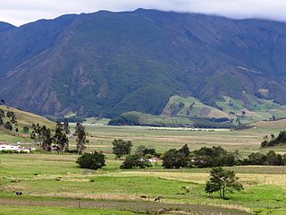
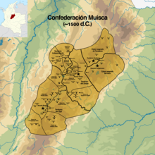
The Altiplano Cundiboyacense is a high plateau located in the Eastern Cordillera of the Colombian Andes covering parts of the departments of Cundinamarca and Boyacá. The altiplano corresponds to the ancient territory of the Muisca. The Altiplano Cundiboyacense comprises three distinctive flat regions; the Bogotá savanna, the valleys of Ubaté and Chiquinquirá, and the valleys of Duitama and Sogamoso. The average altitude of the altiplano is about 2,600 metres (8,500 ft) above sea level but ranges from roughly 2,500 metres (8,200 ft) to 4,000 metres (13,000 ft).

Klein-Venedig or Welserland was the most significant territory of the German colonization of the Americas, from 1528 to 1546, in which the Welser banking and patrician family of the Free Imperial Cities of Augsburg and Nuremberg obtained colonial rights in the Province of Venezuela in return for debts owed by the Holy Roman Emperor Charles V, who was also King of Spain. In 1528, Charles V issued a charter by which the House of Welser possessed the rights to explore, rule and colonize the area, also with the motivation of searching for the legendary golden city of El Dorado. The venture was led at first by Ambrosius Ehinger, who founded Maracaibo in 1529. After the deaths of Ehinger (1533) and then his successor Georg von Speyer (1540), Philipp von Hutten continued exploration in the interior, and in his absence from the capital of the province, the crown of Spain claimed the right to appoint the governor. On Hutten's return to the capital, Santa Ana de Coro, in 1546, the Spanish governor Juan de Carvajal had von Hutten and Bartholomeus VI. Welser executed. King Charles V revoked Welser's charter.
Friar Pedro de Aguado was a Spanish Franciscan friar who spent around 15 years in the New Kingdom of Granada, preaching to the indigenous people. During this time he published a work written by Fray Antonio de Medrano on the history of the region and Medrano's manuscript, Recopilación historial, which was almost ready for publication, between 1576 and 1583 but was unable to publish. The manuscript was used by other historians, but was not published until the twentieth century.
La Vaca or Techovita is a small wetland, part of the Wetlands of Bogotá, located in the locality Kennedy, Bogotá, Colombia. The wetland, in the Tunjuelo River basin on the Bogotá savanna covers an area of about 8 hectares. La Vaca is close to the Avenidad Ciudad de Cali.

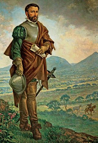
Tisquesusa, also spelled Thisquesuza, Thysquesuca or Thisquesusha was the fourth and last independent ruler (psihipqua) of Muyquytá, main settlement of the southern Muisca between 1514 and his death in 1537. The Spanish pronunciation of his name brought about the Colombian capital Bogotá. Tisquesusa was the ruler of the southern Muisca Confederation at the time of the Spanish conquest of the Muisca, when the troops led by Gonzalo Jiménez de Quesada and his brother entered the central Andean highlands.
The Muisca Confederation was a loose confederation of different Muisca rulers in the central Andean highlands of what is today Colombia before the Spanish conquest of northern South America. The area, presently called Altiplano Cundiboyacense, comprised the current departments of Boyacá, Cundinamarca and minor parts of Santander.

The Moon Temple of Chía was a temple constructed by the Muisca as a place of worship for their Moon goddess Chía. The temple was built in Chía, Cundinamarca, Colombia, then part of the Muisca Confederation. It was one of the most important temples in the religion of the Muisca. The temple was destroyed during the Spanish conquest of the Muisca on the Altiplano Cundiboyacense. Little is known about the temple built on the Tíquiza Hill in western Chía bordering Tabio.
This article describes the role of women in the society of the Muisca. The Muisca are the original inhabitants of the Altiplano Cundiboyacense before the Spanish conquest of the Muisca in the first half of the 16th century. Their society was one of the four great civilizations of the Americas.

The Muzo people are a Cariban-speaking indigenous group who inhabited the western slopes of the eastern Colombian Andes. They were a highly war-like tribe who frequently clashed with their neighbouring indigenous groups, especially the Muisca.

The Tegua or Tecua were an Arawak-speaking indigenous people of Colombia who died out in the 19th century.
The Muisca inhabited the Altiplano Cundiboyacense in the Colombian Andes before the arrival of the Spanish and were an advanced civilisation. They mummified the higher social class members of their society, mainly the zipas, zaques, caciques, priests and their families. The mummies would be placed in caves or in dedicated houses ("mausoleums") and were not buried.
This article describes the economy of the Muisca. The Muisca were the original inhabitants of the Altiplano Cundiboyacense, the high plateau in the Eastern Ranges of central present-day Colombia. Their rich economy and advanced merchant abilities were widely known by the indigenous groups of the area and described by the Spanish conquistadores whose primary objective was the acquisition of the mineral resources of Tierra Firme; gold, emeralds, carbon, silver and copper.

Marianne Vere Cardale de Schrimpff is a Colombian anthropologist, archaeologist, academic and writer.
The Spanish conquest of the Muisca took place from 1537 to 1540. The Muisca were the inhabitants of the central Andean highlands of Colombia before the arrival of the Spanish conquistadors. They were organised in a loose confederation of different rulers; the psihipqua of Muyquytá, with his headquarters in Funza, the hoa of Hunza, the iraca of the sacred City of the Sun Sugamuxi, the Tundama of Tundama, and several other independent caciques. The most important rulers at the time of the conquest were psihipqua Tisquesusa, hoa Eucaneme, iraca Sugamuxi and Tundama in the northernmost portion of their territories. The Muisca were organised in small communities of circular enclosures, with a central square where the bohío of the cacique was located. They were called "Salt People" because of their extraction of salt in various locations throughout their territories, mainly in Zipaquirá, Nemocón, and Tausa. For the main part self-sufficient in their well-organised economy, the Muisca traded with the European conquistadors valuable products as gold, tumbaga, and emeralds with their neighbouring indigenous groups. In the Tenza Valley, to the east of the Altiplano Cundiboyacense where the majority of the Muisca lived, they extracted emeralds in Chivor and Somondoco. The economy of the Muisca was rooted in their agriculture with main products maize, yuca, potatoes, and various other cultivations elaborated on elevated fields. Agriculture had started around 3000 BCE on the Altiplano, following the preceramic Herrera Period and a long epoch of hunter-gatherers since the late Pleistocene. The earliest archaeological evidence of inhabitation in Colombia, and one of the oldest in South America, has been found in El Abra, dating to around 12,500 years BP.
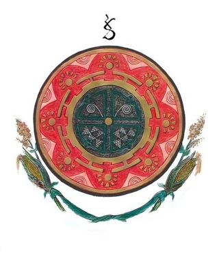
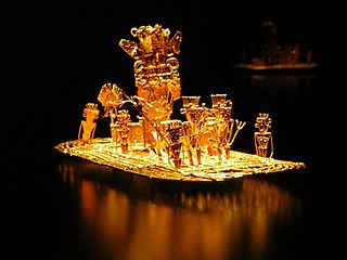
This article describes the art produced by the Muisca. The Muisca established one of the four grand civilisations of the pre-Columbian Americas on the Altiplano Cundiboyacense in present-day central Colombia. Their various forms of art have been described in detail and include pottery, textiles, body art, hieroglyphs and rock art. While their architecture was modest compared to the Inca, Aztec and Maya civilisations, the Muisca are best known for their skilled goldworking. The Museo del Oro in the Colombian capital Bogotá houses the biggest collection of golden objects in the world, from various Colombian cultures including the Muisca.

The Battle of Tocarema was fought between an alliance of the troops of Spanish conquistador Gonzalo Jiménez de Quesada and zipa of the Muisca Sagipa of the southern Muisca Confederation and the indigenous Panche. The battle took place on the afternoon of August 19 and the morning of August 20, 1538 in the vereda Tocarema of Cachipay, Cundinamarca, Colombia and resulted in a victory for the Spanish and Muisca, when captains Juan de Céspedes and Juan de Sanct Martín commanded two flanks of the conquistadors.
Alonso de Herrera was a Spanish conquistador and temporary governor of the Province of Paria.