Gulf of St. Lawrence | |
---|---|
French: Golfe du Saint-Laurent | |
Coordinates | 48°36′N61°24′W / 48.600°N 61.400°W |
Type | Gulf |
Basin countries | Canada Saint Pierre and Miquelon (France) |
Surface area | 226,000 km2 (87,000 sq mi) [1] |
Average depth | 152 m (499 ft) [1] |
Max. depth | 530 m (1,740 ft) [1] |
Water volume | 34,500 km3 (8,300 cu mi) [1] |
The Gulf of St. Lawrence fringes the shores of the provinces of Quebec, New Brunswick, Nova Scotia, Prince Edward Island, Newfoundland and Labrador, in Canada, plus the islands Saint-Pierre and Miquelon, possessions of France, in North America. [2] [3]
The Gulf of St. Lawrence connects the Great Lakes to the Atlantic Ocean via the St. Lawrence River [4] [5] [6]
At Baie-Trinité, the Pointe-des-Monts Lighthouse, a National historic site of Canada, was built in 1829-1830 on a point that ancient geographers, since Samuel de Champlain (1567-1655) himself, classified as the demarcation point between the St. Lawrence River and the Gulf of St. Lawrence. [7] [8]
The Gulf of St. Lawrence is bounded on the north by the Labrador Peninsula and Quebec, to the east by Saint-Pierre and Newfoundland, to the south by the Nova Scotia peninsula and Cape Breton Island, and to the west by the Gaspé Peninsula, New Brunswick, and Quebec. As for significant islands the Gulf of St. Lawrence contains Anticosti Island, Prince Edward Island, Îles-de-la-Madeleine archipelago, Cape Breton Island, Saint Pierre Island, and Miquelon-Langlade.
Half of the ten provinces of Canada adjoin the Gulf: New Brunswick, Nova Scotia, Prince Edward Island, Newfoundland and Labrador, and Quebec.
Besides the Saint Lawrence River itself, significant streams emptying into the Gulf of Saint Lawrence include the Miramichi River, Natashquan River, Romaine River, Restigouche River, Margaree River, Humber River, Mingan River and others.
Branches of the Gulf include the Chaleur Bay, Fortune Bay, Miramichi Bay, St. George's Bay, Bay St. George, Bay of Islands, and Northumberland Strait.
According to Commission of Toponymy Quebec, the St. Lawrence River becomes the gulf at Pointe des Monts on the Côte-Nord and Matane Bas-Saint-Laurent or Sainte-Anne-des-Monts La Haute-Gaspésie, the Estuary is upstream, the Gulf of St. Lawrence, much wider, downstream. [9] [10]
The gulf flows into the Atlantic Ocean through the following outlets:
The Strait of Canso between Cape Breton Island and the Nova Scotia peninsula had been an outlet 1.0 km (0.6 mi) wide and 60 m (200 ft) deep at its deepest. Due to the construction of the Canso Causeway across the strait in 1955, it no longer permits exchange of water between the Gulf of Saint Lawrence and the Atlantic Ocean.
Since its appearance on maps, there has been no consensus on the last section of the St Lawrence River on its designation, whether it is an estuary or a gulf, what are its geographical limits and its hydrological entity ?
Mercator's map of 1569, [15] the Jesuit Relations 1858, [16] the History of French Canada since the Discovery, Abbé Lionel Groulx, 1960, [17] the publications of the government of Canada, [18] the Commission de Toponymie du Québec, [9] doctoral theses and scientific research, do not provide an absolute answer.
According to Fisheries and Oceans Canada 2023, the Estuary and Gulf of St. Lawrence planning area covers most of the Estuary and Gulf of St. Lawrence bioregion, an area with some of the warmest surface waters in Atlantic Canada during summer and the largest amount of sea ice during winter. The planning area is approximately 240,000 km². [3]
According to Encyclopedia Britannica, the name of gulf Saint Lawrence in a hydrologic context is not accurate, a gulf has to be considered more as a sea bordering the North American continent than as simply a river mouth. [19]
The International Hydrographic Organization 1953 said [20] : On the Northeast. A line running from Cape Bauld (North point of Kirpon Island, 51°40′N55°25′W / 51.667°N 55.417°W ) to the East extreme of Belle Isle and on to the Northeast Ledge ( 52°02′N55°15′W / 52.033°N 55.250°W ). Thence a line joining this ledge with the East extreme of Cape St. Charles (52°13'N) in Labrador.
On the Southeast. A line from Cape Canso ( 45°20′N61°0′W / 45.333°N 61.000°W ) to Red Point ( 45°35′N60°45′W / 45.583°N 60.750°W ) in Cape Breton Island, through this Island to Cape Breton [ 45°57′N59°47′W / 45.950°N 59.783°W ] and on to Pointe Blanche ( 46°45′N56°11′W / 46.750°N 56.183°W ) in the Island of St. Pierre, and thence to the southwest point of Morgan Island ( 46°51′N55°49′W / 46.850°N 55.817°W ).
On the West. The meridian of 64°30'W from Pointe-Jaune ( 49°04′N64°30′W / 49.06°N 64.5°W ) to Magpie ( 50°19′N64°30′W / 50.31°N 64.5°W ), but the whole of Anticosti Island is included in the Gulf.
St. Paul Island in Nova Scotia off the northeastern tip of Cape Breton Island, is known as the "Graveyard of the Gulf" because of its many shipwrecks. [21] Access to this island is controlled by the Canadian Coast Guard. [22]
In 1919 the first Migratory Bird Sanctuaries (MBS) in Canada were established under the Migratory Birds Convention Act on Bonaventure Island, on the Bird Rocks of the Magdalen Islands, and on the Percé Rock. These migratory bird sanctuaries are administered by the Canadian Wildlife Service. [23]
The Federal Government of Canada manages the National Parks of Canada along the Gulf of Saint Lawrence at Forillon National Park on the eastern tip of the Gaspé Peninsula, Prince Edward Island National Park on the northern shore of the island, Kouchibouguac National Park on the northeastern coast of New Brunswick, Cape Breton Highlands National Park on the northern tip of Cape Breton Island, Gros Morne National Park on the west coast of Newfoundland, and a National Park Reserve in the Mingan Archipelago on the Côte-Nord of Quebec.[ citation needed ]
The five provinces bordering the Gulf of Saint Lawrence have several provincial parks with protected coasts.[ citation needed ]
The Laurentian Channel is a feature of the floor of the Gulf that was formed during previous ice ages, when the Continental Shelf was eroded by the Saint Lawrence River during the periods when the sea level plunged. The Laurentian Channel is about 290 m (950 ft) deep and about 1,250 km (780 mi) long from the Continental Shelf to the mouth of the Saint Lawrence River. Deep waters with temperatures between 2 and 6.5 °C (36 and 44 °F) enter the Gulf at the continental slope and are slowly advected up the channel by estuariane circulation. [24] Over the 20th century, the bottom waters of the end of the channel (i.e. in the Saint Lawrence estuary) have become hypoxic. [25]
The gulf has provided a historically important marine fishery for various First Nations that have lived on its shores for millennia and used its waters for transportation.[ citation needed ]
The first documented voyage by a European in its waters was by the French explorer Jacques Cartier in the year 1534. Cartier named the shores of the Saint Lawrence River "The Country of Canadas", after an indigenous word meaning "village" or "settlement", thus naming the world's second largest country. [26]
Basque whalers from Saint-Jean-de-Luz sailed into the Gulf of Saint Lawrence in 1530 and began whaling at Red Bay. [27] They established their base on the Strait of Belle Isle and worked closely with the Iroquois in the Gulf of Saint Lawrence. In 1579 the English government closed all English ports to Spanish oil imports. As a result, a third of Basque whale oil could not be sold. Basque whaling collapsed in the Gulf of Saint Lawrence and never recovered.
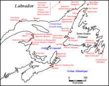
The St. Lawrence River is a large international river in the middle latitudes of North America connecting the Great Lakes to the North Atlantic Ocean. Its waters flow in a northeasterly direction from Lake Ontario to the Gulf of St. Lawrence, traversing Ontario and Quebec in Canada and New York in the United States. A section of the river demarcates the Canada–U.S. border.
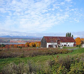
Île d'Orléans is an island located in the Saint Lawrence River about 5 kilometres (3.1 mi) east of downtown Quebec City, Quebec, Canada. It was one of the first parts of the province to be colonized by the French, and a large percentage of French Canadians can trace ancestry to early residents of the island. The island has been described as the "microcosm of traditional Quebec and as the birthplace of francophones in North America."
Chaleur Bay, also Chaleurs Bay, Bay of Chaleur, is an arm of the Gulf of Saint Lawrence located between Quebec and New Brunswick, Canada.
The Island of Montreal is a large island in southwestern Quebec, Canada, that is the site of a number of municipalities, including most of the city of Montreal, and is the most populous island in Canada. It is the main island of the Hochelaga Archipelago at the confluence of the Saint Lawrence and Ottawa rivers.
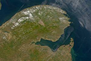
Anticosti is an island, in L'Île-d'Anticosti (Municipality), Minganie Regional County Municipality, administrative region of Côte-Nord, Quebec province, Canada.
The Îles de la Madeleine are an archipelago in the Gulf of St. Lawrence. These 12 islands make up the Les Îles-de-la-Madeleine municipality, in the Gaspésie-Îles-de-la-Madeleine region, Quebec, Canada.
Located in the eastern part of Canada, and part of Central Canada, Quebec occupies a territory nearly three times the size of France or Texas. It is much closer to the size of Alaska. As is the case with Alaska, most of the land in Quebec is very sparsely populated. Its topography is very different from one region to another due to the varying composition of the ground, the climate, and the proximity to water. The Great Lakes–St. Lawrence Lowlands and the Appalachians are the two main topographic regions in southern Quebec, while the Canadian Shield occupies most of central and northern Quebec.
Les Îles-de-la-Madeleine is a municipality located in Gaspésie-Îles-de-la-Madeleine region, in Quebec, Canada. The islands of the archipelago and the municipality are geographical and political versions of the same entity.
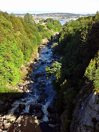
The Rivière du Loup is a river in eastern Quebec, Canada, which empties on the south shore of Saint Lawrence River at the city of Rivière-du-Loup, which is part of the regional county municipality (RCM) Rivière-du-Loup, in the administrative region of Bas-Saint-Laurent.
Baie-Trinité is part of the Manicouagan Regional County Municipality, in Côte-Nord region, Quebec province, Canada.
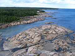
Mingan Archipelago National Park Reserve or Mingan Archipelago Heritage Site bathes in the waters of the Gulf of St. Lawrence, in the administrative region of Côte-Nord, in the municipality of Havre-Saint -Pierre, facing Anticosti Island.
Havre-Saint-Pierre is a Municipality located on the north shore of the Gulf of St. Lawrence, in Côte-Nord region, Minganie Regional County, Quebec, Canada.
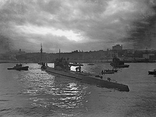
The Battle of the St. Lawrence involved marine and anti-submarine actions throughout the lower St. Lawrence River and the entire Gulf of Saint Lawrence, Strait of Belle Isle, Anticosti Island and Cabot Strait from May–October 1942, September 1943, and again in October–November 1944. During this time, German U-boats sank over 20 merchant ships and four Canadian warships. There were several near-shore actions involving the drop of German spies, or the attempted pickup of escaping prisoners of war. Despite the 23 ships lost, this battle marked a strategic victory for Canadian forces as ultimately they managed to disrupt U-boat activity, protect Canadian and Allied convoys, and intercept all attempted shore operations. This marked the first time that a foreign power had inflicted casualties in Canadian inland waters since the US incursions in the War of 1812.
Blanc-Sablon is the easternmost community in Le Golfe-du-Saint-Laurent Regional County Municipality, in the administrative region of Côte-Nord, in the province of Quebec, Canada. With a population of 1,122 inhabitants in 2021, it is the most populous community in the county municipality.
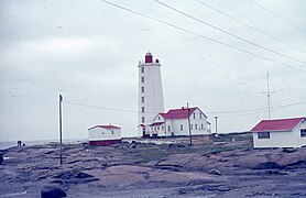
The history of lighthouses in Canada dates to 1734.
Kegaska, population 138, is the easternmost point in the Côte-Nord region of Quebec, Canada to be reachable by road without passing through Newfoundland and Labrador. Quebec Route 138 reached the community on September 26, 2013, with the inauguration of a bridge across the Natashquan River.
St. Lawrence Estuary stretches from west to east for 655 km, from the outlet of Lake Saint Pierre to pointe des Monts, where it becomes the Gulf of St. Lawrence, in Quebec, Canada.
The rivière Jupiter is a watercourse flowing into Gulf of St. Lawrence, flowing in the municipality of L'Île-d'Anticosti, in the Minganie Regional County Municipality, in the administrative region of North Shore, in province of Quebec, in Canada.
A River, Estuaries, a Gulf: The Great Hydrographic Divisions of the St. Lawrence
The area represents one of the largest and most productive estuarine/marine ecosystems in Canada and in the world.
the Gulf must be considered a complete and coherent systern: for example, what happens in the Gaspé current cannot be completely isolated from the phenomena that occur elsewhere. The degree of interdependence of the various areas remains to be explored.
. . . can be divided into three broad sections: the freshwater river, which extends from Lake Ontario to just outside the city of Quebec; the St. Lawrence estuary, which extends from Quebec to Anticosti Island; and the Gulf of St. Lawrence, which leads into the Atlantic Ocean
According to the Royal Proclamation of 1763, a line from the mouth of Rivière St-Jean on the north shore past the western tip of Île d'Anticosti to Cap des Rosiers on Gaspé marks the end of the river and the beginning of the gulf.
Built on a rocky outcrop that forms an islet at high tide, the lighthouse bears witness to a time when navigation in the Gulf of St. Lawrence was perilous.
The first lighthouse, completed in 1830, had walls six feet thick at the base, tapering to two feet at the lantern deck.20
Sixteenth-century cartographers, historians and memorialists were most often inspired by the Spanish and Italian translations of the Brief récit, and not by the original French published in 1545 to impose the toponym Gulf of St. Lawrence
These points serve as a boundary between the Estuary of the St. Lawrence River upstream and the much wider Gulf of St. Lawrence downstream
Anticosti is the best natural laboratory in the world for the study of fossils and sedimentary strata from the first mass extinction of life at the end of the Ordovician period
The Port of Sept-Îles is one of the largest ports in Canada, with world-class companies on the outskirts of the Bay of Sept-Îles
Oil pollution is also a concern due to the proximity of the islands to the main shipping route that leads to the St. Lawrence seaway.
Built in 1870 and 1871, it was erected during the first wave of lighthouse construction to make navigation safe in the Gulf of St. Lawrence
In 1569, Mercator published his epic world map. This map, with its Mercator projection, was designed to help sailors navigate around the globe.
Containing what happened most remarkable in the missions of the fathers of the Society of Jesus in New France
In the absence of decisive, first-hand documents, historians and cartographers can only assert probabilities.
The Gulf of St. Lawrence contains a wide range of hydrodynamic conditions including seasonal ice cover, polynyas, fronts, gyres, freshwater input and influences, and large seasonal variations in vertical stratification.
body of water covering about 60,000 square miles (155,000 square km) at the mouth of the St. Lawrence River. The reefs on these surfaces, coupled with the hazards of fog and ice, have caused a large number of shipwrecks.
Limits of Oceans and Seas
As I stepped ashore onto a blanket-size piece of sand, I realized I was probably trespassing; landing on the island requires an official permit from the Canadian coast guard.