Harlem | |
---|---|
Motto: Heartbeat of the Milk River Valley | |
Coordinates: 48°31′55″N108°47′05″W / 48.53194°N 108.78472°W | |
Country | United States |
State | Montana |
County | Blaine |
Area | |
• Total | 0.42 sq mi (1.08 km2) |
• Land | 0.42 sq mi (1.08 km2) |
• Water | 0.00 sq mi (0.00 km2) |
Elevation | 2,366 ft (721 m) |
Population (2020) | |
• Total | 769 |
• Density | 1,839.71/sq mi (709.82/km2) |
Time zone | UTC-7 (Mountain (MST)) |
• Summer (DST) | UTC-6 (MDT) |
ZIP code | 59526 |
Area code | 406 |
FIPS code | 30-34375 |
GNIS feature ID | 2410702 [2] |
Website | www |
Harlem is a city in Blaine County, Montana, United States. The population was 769 at the 2020 census. [3]
The Fort Belknap Indian Reservation is just south of the town, across the Milk River.
Like other towns along the Hi-Line, Great Northern Railway officials chose the name of a European city for this new town. In this case it was Haarlem, in the Netherlands. A. A. Cecil platted the townsite in 1889. [4]
According to the United States Census Bureau, the city has a total area of 0.43 square miles (1.11 km2), all land. [5]
Climate data for Harlem, Montana (1991–2020 normals, extremes 1896–present) | |||||||||||||
---|---|---|---|---|---|---|---|---|---|---|---|---|---|
Month | Jan | Feb | Mar | Apr | May | Jun | Jul | Aug | Sep | Oct | Nov | Dec | Year |
Record high °F (°C) | 66 (19) | 74 (23) | 82 (28) | 95 (35) | 98 (37) | 107 (42) | 107 (42) | 107 (42) | 102 (39) | 91 (33) | 87 (31) | 69 (21) | 107 (42) |
Mean daily maximum °F (°C) | 28.2 (−2.1) | 32.7 (0.4) | 45.0 (7.2) | 58.8 (14.9) | 69.0 (20.6) | 76.6 (24.8) | 85.0 (29.4) | 84.7 (29.3) | 74.1 (23.4) | 59.7 (15.4) | 43.3 (6.3) | 30.9 (−0.6) | 57.3 (14.1) |
Daily mean °F (°C) | 16.6 (−8.6) | 20.8 (−6.2) | 32.5 (0.3) | 44.4 (6.9) | 54.3 (12.4) | 62.6 (17.0) | 69.3 (20.7) | 68.2 (20.1) | 57.9 (14.4) | 45.1 (7.3) | 31.1 (−0.5) | 19.8 (−6.8) | 43.6 (6.4) |
Mean daily minimum °F (°C) | 5.0 (−15.0) | 8.9 (−12.8) | 19.9 (−6.7) | 29.9 (−1.2) | 39.7 (4.3) | 48.7 (9.3) | 53.5 (11.9) | 51.6 (10.9) | 41.7 (5.4) | 30.4 (−0.9) | 18.9 (−7.3) | 8.7 (−12.9) | 29.7 (−1.3) |
Record low °F (°C) | −50 (−46) | −50 (−46) | −37 (−38) | −12 (−24) | 10 (−12) | 26 (−3) | 35 (2) | 30 (−1) | 13 (−11) | −20 (−29) | −35 (−37) | −44 (−42) | −50 (−46) |
Average precipitation inches (mm) | 0.51 (13) | 0.36 (9.1) | 0.52 (13) | 1.00 (25) | 1.89 (48) | 2.90 (74) | 1.44 (37) | 0.99 (25) | 1.09 (28) | 0.73 (19) | 0.57 (14) | 0.50 (13) | 12.50 (318) |
Average precipitation days (≥ 0.01 in) | 4.8 | 3.6 | 4.7 | 6.2 | 9.5 | 12.1 | 6.7 | 5.2 | 5.3 | 5.0 | 5.3 | 4.0 | 72.4 |
Source: NOAA [6] [7] |
Census | Pop. | Note | %± |
---|---|---|---|
1910 | 383 | — | |
1920 | 721 | 88.3% | |
1930 | 708 | −1.8% | |
1940 | 1,166 | 64.7% | |
1950 | 1,107 | −5.1% | |
1960 | 1,267 | 14.5% | |
1970 | 1,094 | −13.7% | |
1980 | 1,023 | −6.5% | |
1990 | 882 | −13.8% | |
2000 | 848 | −3.9% | |
2010 | 808 | −4.7% | |
2020 | 769 | −4.8% | |
U.S. Decennial Census [8] [3] |
As of the census [9] of 2010, there were 808 people, 307 households, and 204 families residing in the city. The population density was 1,879.1 inhabitants per square mile (725.5/km2). There were 359 housing units at an average density of 834.9 per square mile (322.4/km2). The racial makeup of the city was 42.1% White, 52.2% Native American, 0.1% Pacific Islander, 0.1% from other races, and 5.4% from two or more races. Hispanic or Latino of any race were 4.0% of the population.
There were 307 households, of which 36.2% had children under the age of 18 living with them, 44.6% were married couples living together, 15.6% had a female householder with no husband present, 6.2% had a male householder with no wife present, and 33.6% were non-families. 29.6% of all households were made up of individuals, and 14.7% had someone living alone who was 65 years of age or older. The average household size was 2.49 and the average family size was 3.08.
The median age in the city was 36.6 years. 28.6% of residents were under the age of 18; 8.5% were between the ages of 18 and 24; 22.4% were from 25 to 44; 23.7% were from 45 to 64; and 17% were 65 years of age or older. The gender makeup of the city was 45.3% male and 54.7% female.
As of the census [10] of 2000, there were 848 people, 332 households, and 232 families residing in the city. The population density was 1,976.7 inhabitants per square mile (763.2/km2). There were 401 housing units at an average density of 934.7 per square mile (360.9/km2). The racial makeup of the city was 52.59% White, 0.24% African American, 42.57% Native American, 0.24% Asian, 0.12% from other races, and 4.25% from two or more races. Hispanic or Latino of any race were 1.65% of the population.
There were 332 households, out of which 33.4% had children under the age of 18 living with them, 51.2% were married couples living together, 15.1% had a female householder with no husband present, and 30.1% were non-families. 29.5% of all households were made up of individuals, and 11.7% had someone living alone who was 65 years of age or older. The average household size was 2.50 and the average family size was 3.09.
In the city, the population was spread out, with 29.4% under the age of 18, 7.9% from 18 to 24, 22.4% from 25 to 44, 23.7% from 45 to 64, and 16.6% who were 65 years of age or older. The median age was 37 years. For every 100 females there were 89.7 males. For every 100 females age 18 and over, there were 93.2 males.
The median income for a household in the city was $27,794, and the median income for a family was $33,828. Males had a median income of $24,145 versus $21,750 for females. The per capita income for the city was $13,295. About 16.5% of families and 23.0% of the population were below the poverty line, including 32.8% of those under age 18 and 8.5% of those age 65 or over.
Harlem is home to Harlem Elementary, Middle School and Harlem High School. [11] The team name is the Wildcats. [12]
The Harlem Elementary District consists of a grade school with students from kindergarten to 6th grade and a middle school for 7th and 8th grade students. The district had a total of 453 students enrolled for the 2021-2022 school year. [13]
The Harlem High School educates students from 9th to 12th grade. In the 2021-2022 school year, 175 students were enrolled. [14]
Aaniiih Nakoda College is a two year institution in the town. [15] It offers associate degrees in eleven disciplines and vocational training in five others
Harlem Public Library serves the area. [16]
The Blaine County Journal News-Opinion is a local weekly newspaper. [17] It is available in print or online.
U.S. Route 2 forms the southern border of the town. Highway 241 exits north of town and leads to the Turner–Climax Border Crossing.
Harlem Airport is a public use airport located three miles (6 km) north of town. [18] The nearest commercial airport is Havre City–County Airport, 48 miles (77 km) east. It offers regional flights only. For full flight service, residents must travel to either Great Falls International Airport or Billings Logan International Airport, both about 200 miles (322 km) away.
Amtrak’s Empire Builder, which operates between Seattle/Portland and Chicago, passes through the town on BNSF tracks, but makes no stop. The nearest stations are located in Havre, 43 miles (69 km) to the west, and Malta, 45 miles (72 km) to the east.
Blaine County is a county in the U.S. state of Montana. As of the 2020 census, the population was 7,044. Its county seat is Chinook. The county was named for James G. Blaine, former United States Secretary of State. It is on the north line of the state, and thus shares the southern border of Canada opposite Saskatchewan.
Chinook is a city in and the county seat of Blaine County, Montana, United States. The population was 1,185 at the 2020 census. Points of interest are the Bear Paw Battlefield Museum located in the small town's center and the Bear Paw Battlefield, located 20 miles (32 km) south of Chinook.
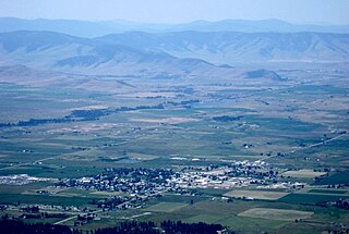
Fort Belknap Agency is a census-designated place (CDP) in Blaine County, Montana, United States. As of the 2020 census, its population was 1,567. This is a significant increase from the 2010 census which reported 1,293 residents.
Hays is a census-designated place (CDP) in Blaine County, Montana, United States. The population was 843 at the 2010 census. The community lies within the Fort Belknap Indian Reservation, near the reservation's southern end. The nearby community of Lodge Pole lies to the east.
Townsend is a city in and the county seat of Broadwater County, Montana, United States. The population was 1,787 at the 2020 census.
Ekalaka is a town in and the county seat of Carter County, Montana, United States. The population was 399 at the 2020 census.
Geraldine is a town in Chouteau County, Montana, United States. The population was 207 at the 2020 census. The area around the town is an agricultural, largely wheat-producing, region.
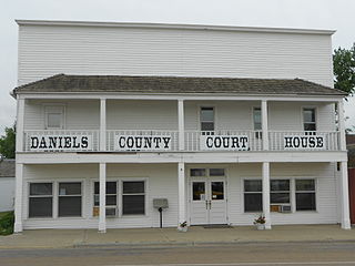
Scobey is a city in and the county seat of Daniels County, Montana, United States. The population was 999 at the 2020 census.
Winifred is a small town in rural north-central Fergus County, Montana, United States. It was founded in 1913 and provides services for its region's populace. The town population was 172 at the 2020 census. The current mayor is Travis Willson.
Jordan is a town in and the county seat of Garfield County, Montana, United States. The population was 356 at the 2020 census. It is Garfield County's only incorporated community.
Ennis is a town in Madison County, Montana, United States, in the southwestern part of the state. The population was 917 at the 2020 census.
White Sulphur Springs is a city in and the county seat of Meagher County, Montana, United States. The population was 955 at the 2020 census.
Conrad is a city in and the county seat of Pondera County, Montana, United States. The population was 2,318 at the 2020 census. Each June, the Whoop Up Days, a town wide celebration that includes a parade and rodeo, takes place in Conrad.
Sidney is a city in and the county seat of Richland County, Montana, United States, less than 10 mi (16 km) west of the North Dakota border. The population was 6,346 at the 2020 census. The city lies along the Yellowstone River and is in proximity to the badlands of the Dakotas. Sidney is approximately midway between Glendive, Montana and Williston, North Dakota.
Thompson Falls is a city in and the county seat of Sanders County, Montana. The population was 1,336 at the time of the 2020 census.
Columbus is a town in and the county seat of Stillwater County, Montana, United States. The population was 1,857 at the 2020 census.
Park City is a census-designated place (CDP) in Stillwater County, Montana, United States. The population was 870 at the 2000 census.
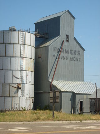
Plevna is a town in Fallon County, Montana, United States. The population was 179 at the 2020 census.
Polson is a city in , United States, on the southern shore of Flathead Lake and within the Flathead Indian Reservation. The population was 5,148 at the 2020 census. It is the county seat of Lake County. In 1898 the city was named after pioneer rancher David Polson. It was incorporated in 1910.
Ronan is a city in Lake County, Montana, United States. It is on the Flathead Indian Reservation. The population was 1,955 at the 2020 census.