Lodge Pole, Montana

Last updated
Lodge Pole, Montana
Blaine County Montana Incorporated and Unincorporated areas Lodge Pole Highlighted.svg
Location of Lodge Pole, Montana
Coordinates: 48°1′58″N108°32′9″W / 48.03278°N 108.53583°W / 48.03278; -108.53583 Coordinates: 48°1′58″N108°32′9″W / 48.03278°N 108.53583°W / 48.03278; -108.53583
Country United States
State Montana
County Blaine
Area
[1]
  Total13.39 sq mi (34.68 km2)
  Land13.39 sq mi (34.68 km2)
  Water0.00 sq mi (0.00 km2)
Elevation
3,409 ft (1,039 m)
Population
 (2020)
  Total294
  Density21.96/sq mi (8.48/km2)
Time zone UTC-7 (Mountain (MST))
  Summer (DST) UTC-6 (MDT)
Area code 406
FIPS code 30-44350
GNIS feature ID0773540

Lodge Pole is a census-designated place (CDP) in Blaine County, Montana, United States. The population was 265 at the 2010 census. [2] It lies within the Fort Belknap Indian Reservation, near the reservation's southern end.

Contents

The nearby community of Hays lies to its west-southwest.

Geography

Lodge Pole is located at 48°1′58″N108°32′9″W / 48.03278°N 108.53583°W / 48.03278; -108.53583 (48.032665, -108.535716). [3]

According to the United States Census Bureau, the CDP has a total area of 13.4 square miles (34.7 km2), all land. [2]

Demographics

Historical population
CensusPop.
2020 294
U.S. Decennial Census [4]

As of the census [5] of 2000, there were 214 people, 59 households, and 48 families residing in the CDP. The population density was 16.0 people per square mile (6.2/km2). There were 69 housing units at an average density of 5.2/sq mi (2.0/km2). The racial makeup of the CDP was 2.34% White, 96.73% Native American, and 0.93% from two or more races.

While Lodge Pole is located on a reservation belonging to both Assiniboine people and Gros Ventre people, the community itself is primarily inhabited by Assiniboine people, while nearby Hays is home to Gros Ventre. [6]

There were 59 households, out of which 50.8% had children under the age of 18 living with them, 42.4% were married couples living together, 25.4% had a female householder with no husband present, and 18.6% were non-families. 16.9% of all households were made up of individuals, and 1.7% had someone living alone who was 65 years of age or older. The average household size was 3.63 and the average family size was 3.90.

In the CDP, the population was spread out, with 45.3% under the age of 18, 5.1% from 18 to 24, 27.1% from 25 to 44, 16.4% from 45 to 64, and 6.1% who were 65 years of age or older. The median age was 24 years. For every 100 females, there were 94.5 males. For every 100 females age 18 and over, there were 91.8 males.

The median income for a household in the CDP was $21,607, and the median income for a family was $22,500. Males had a median income of $21,250 versus $19,375 for females. The per capita income for the CDP was $6,276. About 44.0% of families and 40.9% of the population were below the poverty line, including 42.7% of those under the age of eighteen and 77.8% of those 65 or over.

Education

Lodge Pole has an elementary school. High school is at Hays-Lodgepole High School in nearby Hays. [7]

Related Research Articles

<span class="mw-page-title-main">Blaine County, Montana</span> County in Montana, United States

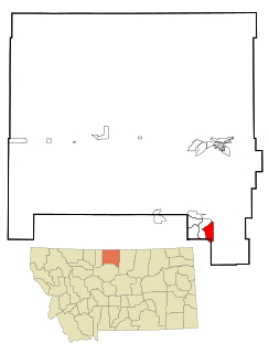
Blaine County is a county in the U.S. state of Montana. As of the 2020 census, the population was 7,044. Its county seat is Chinook. The county was named for James G. Blaine, former United States Secretary of State. It is on the north line of the state, and thus shares the southern border of Canada opposite Saskatchewan.

<span class="mw-page-title-main">Kasigluk, Alaska</span> Census-designated place in Alaska, United States

Kasigluk is a census-designated place (CDP) in the Bethel Census Area in the U.S. state of Alaska. At the 2010 census the population was 569, up from 543 in 2000. Kasigluk consists of two smaller villages, called Akiuk and Akula.

<span class="mw-page-title-main">Peach Springs, Arizona</span> CDP in Mohave County, Arizona

Peach Springs is a census-designated place (CDP) in Mohave County, Arizona, United States. The population was 1,098 at the 2020 census. Peach Springs serves as the administrative headquarters of the Hualapai people and is located on the Hualapai Reservation.

<span class="mw-page-title-main">Pryor, Montana</span> Census-designated place in Montana, United States

Pryor is a census-designated place (CDP) in Big Horn County, Montana, United States. The community is located on Crow Tribe's reservation. The population was 618 at the 2010 census. The area is named for Nathaniel Hale Pryor, a sergeant in the Lewis and Clark Expedition.

<span class="mw-page-title-main">Chinook, Montana</span> City in Montana, United States

Chinook is a city in and the county seat of Blaine County, Montana, United States. The population was 1,185 at the 2020 census. Points of interest are the Bear Paw Battlefield Museum located in the small town's center and the Bear Paw Battlefield, located twenty miles south of Chinook.

<span class="mw-page-title-main">Fort Belknap Agency, Montana</span> Census-designated place in Montana, United States

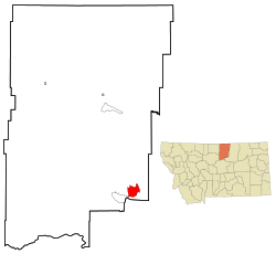
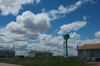
Fort Belknap Agency is a census-designated place (CDP) in Blaine County, Montana, United States. As of the 2010 census, its population was 1,293.

<span class="mw-page-title-main">Hays, Montana</span> Census-designated place in Montana, United States

Hays is a census-designated place (CDP) in Blaine County, Montana, United States. The population was 843 at the 2010 census. The community lies within the Fort Belknap Indian Reservation, near the reservation's southern end. The nearby community of Lodge Pole lies to the east.

<span class="mw-page-title-main">Simms, Montana</span> CDP in Montana, United States

Simms is a census-designated place (CDP) in Cascade County, Montana, United States. The population was 354 at the 2010 census. It is part of the Great Falls, Montana Metropolitan Statistical Area.

<span class="mw-page-title-main">Lodgepole, Nebraska</span> Village in Nebraska, United States

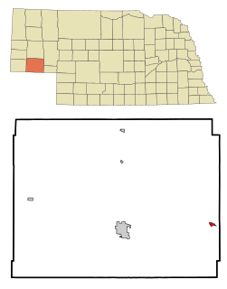
Lodgepole is a village in Cheyenne County, Nebraska, United States. The population was 318 at the 2010 census.

<span class="mw-page-title-main">Zuni Pueblo, New Mexico</span> Census-designated place in New Mexico, United States

Zuni Pueblo is a census-designated place (CDP) in McKinley County, New Mexico, United States. The population was 6,302 as of the 2010 Census. It is inhabited largely by members of the Zuni people (A:shiwi).

<span class="mw-page-title-main">Dulce, New Mexico</span> Census-designated place in New Mexico, United States

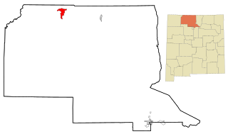
Dulce is a census-designated place (CDP) in Rio Arriba County, New Mexico, United States. The population was 2,743 at the 2010 census, almost entirely Native American. It is the largest community and tribal headquarters of the Jicarilla Apache Reservation.

<span class="mw-page-title-main">Upper Fruitland, New Mexico</span> CDP in New Mexico, United States

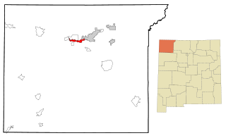
Upper Fruitland is a census-designated place (CDP) in San Juan County, New Mexico, United States. The population was 1,664 at the 2000 census. It is part of the Farmington Metropolitan Statistical Area.

<span class="mw-page-title-main">Shell Valley, North Dakota</span> Census-designated place & Unincorporated community in North Dakota, United States

Shell Valley is a census-designated place (CDP) in Rolette County, North Dakota, United States. The population was 1,146 at the 2020 census.

Ancient Oaks is a census-designated place (CDP) in Lower Macungie Township in Lehigh County, Pennsylvania. It is named after the housing subdivision named Ancient Oaks, located off PA Route 100 just north of Macungie. The population of Ancient Oaks was 6,995 at the 2020 census.

<span class="mw-page-title-main">Allen, South Dakota</span> CDP in South Dakota, United States

Allen is a census-designated place on the Pine Ridge Indian Reservation in Bennett County, South Dakota, United States, that was named for the Allen Township, which it encompasses. As of the 2020 census, the CDP had a population of 460. It is one of two places which are closest to the North American continental pole of inaccessibility.

<span class="mw-page-title-main">Kyle, South Dakota</span> CDP in South Dakota, United States

Kyle is a census-designated place (CDP) in Oglala Lakota County, South Dakota, United States. Its population was 943 at the 2020 census. Located within the Pine Ridge Indian Reservation of the Oglala Lakota, it is one of two settlements which are closest to the North American continental pole of inaccessibility.

<span class="mw-page-title-main">Arapahoe, Wyoming</span> Census-designated place in Wyoming, United States

Arapahoe is a census-designated place (CDP) in Fremont County, Wyoming, United States. The population was 1,656 at the 2010 census. A Catholic mission was founded here in 1884. St Stephen's Mission Church, located near Arapahoe, is part of the Catholic mission.

<span class="mw-page-title-main">Ethete, Wyoming</span> CDP in Wyoming, United States

Ethete is a census-designated place (CDP) in Fremont County, Wyoming, United States. The population was 1,553 at the 2010 census. The town is located on the Wind River Indian Reservation. It grew up around the Episcopal St. Michael's Mission.

<span class="mw-page-title-main">Daniel, Wyoming</span> CDP in Wyoming, United States

Daniel is a census-designated place in Sublette County, Wyoming, United States. The population was 150 at the 2010 census.

<span class="mw-page-title-main">Parker School, Montana</span> Census-designated place in Montana, United States

Parker School is a census-designated place (CDP) in Hill and Chouteau counties in the U.S. state of Montana. The population was 340 at the 2010 census.

References

  1. "ArcGIS REST Services Directory". United States Census Bureau. Retrieved September 5, 2022.
  2. 1 2 "Geographic Identifiers: 2010 Demographic Profile Data (G001): Lodge Pole CDP, Montana". U.S. Census Bureau, American Factfinder. Archived from the original on February 12, 2020. Retrieved June 26, 2013.
  3. "US Gazetteer files: 2010, 2000, and 1990". United States Census Bureau. 2011-02-12. Retrieved 2011-04-23.
  4. "Census of Population and Housing". Census.gov. Retrieved June 4, 2016.
  5. "U.S. Census website". United States Census Bureau . Retrieved 2008-01-31.
  6. Cowell, A.; Taylor, A.; Brockie, T. (2016). "Gros Ventre ethnogeography and place names: A diachronic perspective". Anthropological Linguistics. 58 (2): 132–170. doi:10.1353/anl.2016.0025. S2CID   151520012.
  7. "Hays-Lodgepole High School". Hays-Lodgepole School. Retrieved 14 April 2021.