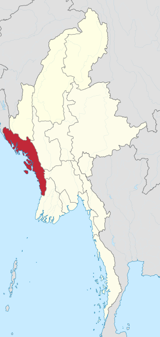
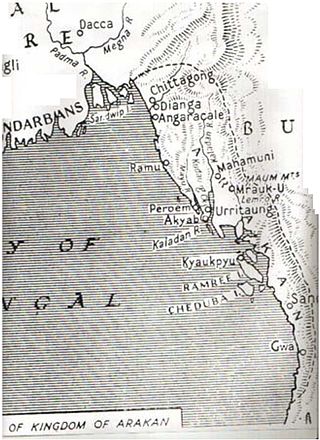
Rakhine State occupies the northern coastline of Myanmar up to the border with Bangladesh and corresponds to the historical Kingdom of Arakan. The history of Rakhine is divided into 7 parts - the independent kingdoms of Dhanyawadi, Waithali, Lemro, Mrauk U, Burmese occupation from 1785 to 1826, British rule from 1826 to 1948 and as a part of independent Burma from 1948.
The Arakanese kingdom was conquered on December 31, 1784, by the Burmese Konbaung dynasty. In 1826, Arakan was ceded to the British as war reparation after the First Anglo-Burmese War. It became part of the Province of Burma of British India in 1886, after the annexation of Burma by the British. Arakan became part of the Crown Colony of British Burma which was split off from British India in 1937. Northern Rakhine state became a contested battleground throughout the Japanese occupation of Burma. After 1948, Rakhine became part of the newly independent state of Burma. However, the independence of Arakan was just in paper after a few years because Myanmenization or nationalism of Myanmar broke up civil war across nationwide. In 1973, Arakan became a state of the Socialist Republic of the Union of Burma, designated as the homeland of the Rakhine people.
Sporadic communal strife has plagued Arakan since colonial times, between the majority Arakanese who are Buddhist, and Muslim communities, many but not all of whom came into Arakan with British rule. The latest conflagration was in June and October 2012.
Arakanese legends claim that the history of the Arakanese people began in Rakhine although archaeological evidence supporting this claim is unavailable. Earliest recording evidence suggests the civilization founded around the 4th century AD. "The presently dominant Rakhine are a Tibeto-Burman race, the last group of people to enter Arakan during 10th century and on.” (Pamela; The Lost Kingdom, Bangkok, 2002, P-5)]. Various Arakanese kingdoms stretched from the Ganges Delta to Cape Negrais on the Irrawaddy Delta.
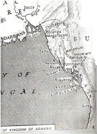
Ancient Dhanyawadi lies west of the mountain ridge between the Kaladan and Le-mro rivers. Dhannyawadi could be reached by small boat from the Kaladan via its tributary, the Tharechaung. Its city walls were made of brick, and form an irregular circle with a perimeter of about 9.6 kilometres (6.0 miles), enclosing an area of about 4.42km2 (1,090 acres). Beyond the walls, the remains of a wide moat, now silted over and covered by paddy fields, are still visible in places. The remains of brick fortifications can be seen along the hilly ridge which provided protection from the west. Within the city, a similar wall and moat enclose the palace site, which has an area of 26 hectares (64 acres), and another wall surrounds the palace itself.
At times of insecurity, when the city was subject to raids from the hill tribes or attempted invasions from neighbouring powers, there would have been an assured food supply enabling the population to withstand a siege. The city would have controlled the valley and the lower ridges, supporting a mixed wet-rice and taungya (slash and burn) economy, with local chiefs paying allegiance to the king.
From aerial photographs we can discern Dhannyawadi's irrigation channels and storage tanks, centred at the palace site. Throughout the history of Rakhine, and indeed the rest of early Southeast Asia, the king's power stemmed from his control of irrigation and water storage systems to conserve the monsoon rains and therefore to maintain the fertility and prosperity of the land. In ceremonies conducted by Indian Brahmins the king was given the magic power to regulate the celestial and terrestrial forces to control the coming of the rains which would ensure the continuing prosperity of the kingdom.
It has been estimated that the centre of power of the Arakanese world shifted from Dhanyawadi to Waithali in the 4th century AD as Dhanyawadi Kingdom ended in 370 AD. Although it was established later than Dhanyawadi, Waithali is the most Indianized of the four Arakanese kingdoms to emerge. Like all of the Arakanese Kingdoms to emerge, the Kingdom of Waithali was based on trade between the East (Pyu city-states, China, the Mons), and the West (India, Bengal, and Persia).[citation needed] The kingdom flourished off of China-India maritime routes.[1] Waithali was a famed trade port with thousands of ships coming annually at its height. The city was built on the banks of a tidal creek and was enclosed by brick walls. The layout of the city had significant Hindu and Indian influence.[2]
According to the Anandachandra Inscription, carved in 729 AD, the subjects of the Waithali Kingdom practiced Mahayana Buddhism, and proclaims that the ruling dynasty of the kingdom were descendants of the Hindu god, Shiva. Dr. E. H. Johnston's analysis reveals a list of kings which he considered reliable beginning from a king named Bahubali.[3][4] The western face inscription has 72 lines of text recorded in 51 verses describing the Anandachandra's predecessor rulers. Each face recorded the name and ruling period of each king who were believed to have ruled over the land before Anandachandra. The Sanskrit text of the inscription remains unique in Myanmar, as Sanskrit was not widely used outside Arakan. The inscription further alludes to political connections with Sri Lanka and Andhra in regard to religious connections.[5]
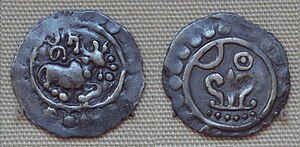
The first ruler of the Waithali Kingdom was Bahubali.[3] Many years after his reign, a dynasty was established in Waithali, which was known as Annaveta dynasty. They were followed by an anonymous dynasty, which ruled till 370 AD. In 370 AD, the last ruler of this anonymous dynasty, known as Lanki, was defeated by a chieftain named Dvenchandra (or Mahataing Chandra), who established a dynasty named Chandra dynasty, so called because of their usage of the god Chandra on Waithali coins. The Waithali period is many as the beginning of Arakanese coinage - which was almost a millennium earlier than that of the Burmese. On the reverse of the coins, the Srivatsa (Rakhine: Thiriwutsa), while the obverse bears a bull, the emblem of the Chandra dynasty, under which the name of the King is inscribed in Sanskrit. The motifs used were in the Brahmanical traditional and included the bell, votive flowers, the trishula among others.[2] The art style of the coins have many parallels to the Gupta art style. Motifs found on the coins were also found throughout late 1st millennium coins from nearby neighbors, including in Chittagong, Dvaravati and Champa.[1]
There is some disagreement between different writers about the last ruler of the Chandra dynasty. According to some writers, the last king of Chandra dynasty was Dharmasura, who was defeated by a chieftain named Vajrasakti. Vajrasakti established the Dharmaraja-andaja dynasty (or Dev-andaja or Deva dynasty).[4][3] Anandachandra (the same king who had made the Anandachandra Inscription) was the grandson of Vajrasakti. While some other writers believe that the last four rulers mentioned in the Anandachandra Inscription indeed belonged to the Chandra dynasty (including Anandachandra himself).[6]
Flag of Rakhine State, showing Srivatsa
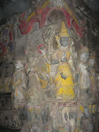
Some important and badly damaged life-size Buddha images were recovered from Letkhat-Taung, a hill east of the old palace compound. These statues are invaluable in helping to understand the Waithalian architecture, and also the extent of Hindu influence in the kingdom.[7]
According to local legend, Shwe-taung-gyi ( lit.'Great Golden Hill'), a hill north-east of the palace compound may be a burial place of a 10th-century Pyu king.[citation needed]
The Kingdom eventually declined in the 10th century, with Rakhine's political core moving to the Le-mro valley states at the same time as the rise of the Bagan Kingdom in central Myanmar. Some historians conclude that the decline was from a takeover or from the immigration of the Mranma (Bamar people) in the 10th century.[1]
Le-Mro in the Rakhine language means "four cities," which refers to the four ancient Rakhine cities that flourished by the side of the Lemro River. Now Only some remain of that cities in Lemro River.
Mrauk-U, or Arrakan (city of Arrakan), in the first plan the Portuguese settlement of Daingri-pet. In Wouter Schouten: Oost-Indische Voyagie, t.o. p. 148. 1676
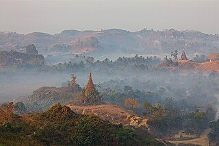
Mrauk U may seem to be a sleepy village today but not so long ago it was the capital of the Arakan empire where Portuguese, Dutch and French traders rubbed shoulders with the literati of Bengal and Mughal princes on the run. Mrauk U was declared capital of the Arakanese kingdom in 1430. At its peak, Mrauk U controlled half of Bangladesh, modern day Rakhine State (Arakan) and the western part of Lower Burma. Pagodas and temples were built as the city grew, and those that remain are the main attraction of Mrauk-U. From the 15th to 18th centuries, Mrauk U was the capital of a mighty Arakan kingdom, frequently visited by foreign traders (including Portuguese and Dutch), and this is reflected in the grandeur and scope of the structures dotted around its vicinity.[8]
The old capital of Rakhine (Arakan) was first constructed by King Min Saw Mon in the 15th century, and remained its capital for 355 years. The golden city of Mrauk U became known in Europe as a city of oriental splendor after Friar Sebastian Manrique visited the area in the early 17th century. Father Manrique's vivid account of the coronation of King Thiri Thudhamma in 1635 and about the Rakhine Court and intrigues of the Portuguese adventurers fire the imagination of later authors. The English author Maurice Collis who made Mrauk U and Rakhine famous after his book, The Land of the Great Image based on Friar Manrique' travels in Arakan.
The Mahamuni Buddha Image, which is now in Mandalay, was cast and venerated 15 miles from Mrauk U where another Mahamuni Buddha Image flanked by two other Buddha images. Mrauk U can be easily reached via Sittwe, the capital of Rakhine State. From Yangon there are daily flights to Sittwe and there are small private boats as well as larger public boats plying through the Kaladan river to Mrauk U. It is only 45 miles from Sittwe and the seacoast. To the east of the old city is the famous Kispanadi stream and far away the Lemro river. The city area used to have a network of canals. Mrauk U maintains a small archaeological Museum near Palace site, which is right in the centre of town. As a prominent capital Mrauk U was carefully built in a strategic location by levelling three small hills. The pagodas are strategically located on hilltops and serve as fortresses; indeed they are once used as such in times of enemy intrusion. There are moats, artificial lakes and canals and the whole area could be flooded to deter or repulse attackers. There are innumerable pagodas and Buddha images around the old city and the surrounding hills. While some are still being used as places of worship today, others are in ruins, some of which are now being restored to their original splendor.[9]
The city eventually reached a size of 160,000 in the early 17th century.[10] Mrauk U served as the capital of the Mrauk U kingdom and its 49 kings until the conquest of the kingdom by the Burmese Konbaung dynasty in 1784.
Trading city
Due to its proximity to the Bay of Bengal, Mrauk U developed into an important regional trade hub, acting as both a back door to the Burmese hinterland and also as an important port along the eastern shore of the Bay of Bengal. It became a transit point for goods such as rice, ivory, elephants, tree sap and deer hide from Ava in Burma, and of cotton, slaves, horses, cowrie, spices and textiles from Bengal, India, Persia and Arabia. Alongside Pegu and later Syriam, it was one of the most important ports in Burma until the 18th century.[citation needed]
The city also traded with non-Asian powers such as Portugal and then the VOC of the Netherlands. The VOC established trading relations with the Arakanese in 1608 after the Portuguese fell in favour due to the lack of loyalty of Portuguese mercenaries, such as Filipe de Brito e Nicote in the service of the Arakanese king. The VOC established a permanent factory in Mrauk U in 1635, and operated in Arakan until 1665.[11]
At its zenith, Mrauk U was the centre of a kingdom which stretched from the shores of the Ganges river to the western reaches of the Ayeyarwady River. According to popular Arakanese legend, there were 12 'cities of the Ganges' which constitute areas around the borders of present-day Bangladesh which were governed by Mrauk U, including areas in the Chittagong Division. During that period, its kings minted coins inscribed in Arakanese, Arabic and Bengali.
Much of Mrauk U's historical description is drawn from the writings of Friar Sebastian Manrique, a Portuguese Augustinian friar who resided in Mrauk U from 1630 to 1635.
Colonial period
The people of Rakhine resisted the conquest of the kingdom for decades after. Fighting with the Rakhine resistance, initially led by Nga Than Dè and finally by Chin Byan in border areas, created problems between British India and Burma. The year 1826 saw the defeat of the Bamar in the First Anglo-Burmese War and Rakhine was ceded to Britain under the Treaty of Yandabo. Sittwe (Akyab) was then designated the new capital of Rakhine. In 1852, Rakhine was merged into Lower Burma as a territorial division.
During the Second World War, Rakhine (Arakan) was given autonomy under the Japanese occupation and was even granted its own army known as the Arakan Defence Force. The Arakan Defence Force went over to the Allies and turned against the Japanese in early 1945.
Part of independent Burma
Upon independence in 1948, Rakhine (Arakan) became a division within the Union of Burma. Shortly after, violence broke out along religious lines between Buddhists and Muslims. Later there were calls for secession by the Rakhine (Arakan), but such attempts were subdued.[citation needed] In 1974, the Ne Win government's new constitution granted Rakhine (Arakan) Division the status of a Union state. In 1989, the name of Arakan State was changed to "Rakhine" by the military junta.
Silver coin of king Nitichandra of Arakan in 8th century (British Museum). Most Arakan coins had the name of the ruling king on one side and the logo of the sun and moon and srivatsa on the other side.
The oldest artefact, stone image of Fat Monk inscribed "Saccakaparibajaka Jina" in Brahmi script inscription comes to the date of first century AD.
An ancient stone inscription in Nagari character was discovered by the archaeologist Forchhammer. Known as Salagiri, this hill was where the great teacher came to Rakhine some 2500 years ago.[citation needed] Somewhere from eastern part of this hill, a stone image in Dhamma-cakra-mudra now kept in Mrauk-U museum, was found earlier in 1923. This relief sculpture found on the Salagiri Hill represents Bengali Hindu king Chandra Suriya belongs to 4th century CE; five more red sandstone slabs with the carving were found close by the south of this Salagiri Hill in 1986. They are the same type as the single slab found earlier in 1923. These carving slabs of Bhumispara-mudra, Kararuna-mudra, Dhammacakra-mudara, and Mmahaparinibbana-mudra represent the life of Buddha.
These sculptures provide earliest evident about the advent of Buddhism into Rakhine; during the lifetime of the Buddha and these discoveries were therefore assumed as the figures of King Chandra Suriya of Dyanawadi, who dedicated the Great Maha Muni Image. These archaeological findings have been studied by eminent scholars and conclusion is that the Maha Muni was made during the king Sanda Suriya era.
The founder of Vesali city, King Dvan Chandra carved Vesali Paragri Buddha-image in AD 327 and set a dedicatory inscription in Pali verse:
ye dhamma hetuppabhava / Tathagato aha / tesan ca yo nirodho / evamvadi Mahasamano.
That Buddha-image is carved out by a single block and the earliest image of Vesali.
Of these dhammas which arise from causes / The Tathagata has declared causes / Lord Buddha preached about the causes / And the effects gained by the causes / And that which is the ceasing of them, Nirawda Thitesa / This the great ascetic declares.
The verse, which is considered as the essence of Theravada spirit, bears testimony to the fact that Buddhism flourished to an utmost degree in Vesali. The relationship of Vesali with foreign countries especially Ceylon would be established for Buddhism.
Anandachandra Inscriptions date back to 729 originally from Vesali, now preserved at Shitethaung, indicates adequate evidence for the earliest foundation of Buddhism. Dr. E. H. Johnston's analysis reveals a list of kings which he considered reliable beginning from Chandra dynasty. The western face inscription has 72 lines of text recorded in 51 verses describing the Anandachandra's ancestral rulers. Each face recorded the name and ruling period of each king who were believed to have ruled over the land before Anandachandra. Archaeology has shown that the establishment of so many stone pagodas and inscriptions which have been totally neglected for centuries in different part of Rakhine speak of popular favoured by Buddhism.
The cubic stone inscriptions record the peace making between the governor of Thandaway (Sandoway) Mong Khari (1433–1459, known in Burmese as Min Khayi) and Razadhiraj the Mon Emperor in Rakhine inscription. This was found from a garrison hill at the oldest site of Parein. A stone slab with the alleged figure of the Hindu Bengali King Chandra Suriya bore testimony to the Salagiri tradition, depicting of the advent of the Teacher to Dyanyawaddy.
Rakhine State is a state in Myanmar (Burma). Situated on the western coast, it is bordered by Chin State to the north, Magway Region, Bago Region and Ayeyarwady Region to the east, the Bay of Bengal to the west and the Chittagong Division of Bangladesh to the northwest. It is located approximately between latitudes 17°30' north and 21°30' north and longitudes 92°10' east and 94°50' east. The Arakan Mountains or Rakhine Yoma separated Rakhine State from central Burma from North to South. Off the coast of Rakhine State there are some fairly large islands such as Ramree, Cheduba and Myingun. Rakhine State has an area of 36,762 square kilometres (14,194 sq mi) and its capital is Sittwe.
The Marma, also known as Moghs, Mogs or Maghs, are the second-largest ethnic community in Bangladesh's Chittagong Hill Tracts, primarily residing in the Bandarban, Khagrachari and Rangamati Hill Districts. They belong to the same community as the Rakhine people. Some Marmas live in Bangladesh's coastal districts of Cox's Bazar and Patuakhali, while others live in Tripura, India and Myanmar. There are about 224,261 Marmas living in Bangladesh and 35,722 of them living in India. Since the 16th century, the Marma have considered the Bengal's Chittagong Hill Tracts their home, where they have established the Bohmong and Mong Circles (chiefdoms).
Sittwe is the capital of Rakhine State, Myanmar (Burma). Sittwe, pronounced sait-tway in the Rakhine language, is located on an estuarial island created at the confluence of the Kaladan, Mayu, and Lay Mro rivers emptying into the Bay of Bengal. As of 2006 the city has 181,000 inhabitants. It is the administrative seat of Sittwe Township and Sittwe District.
Mrauk U is a town in northern Rakhine State, Myanmar. It is the capital of Mrauk-U Township, a subregion of the Mrauk-U District.
The Chandra dynasty was a Buddhist dynasty, originating from the Bengal region of Indian subcontinent, which ruled the Samatata area of Bengal, as well as northern Arakan. Later it was a neighbor to the Pala Empire to the north. Rulers of Chandra kingdom were adherents of Buddhism. The Kings of Chandra dynasty were identified as the kings of Vangaladesha in the Tirumulai inscription of Chola dynasty. The dynasty was founded around the 4th century AD.
The Shaitthaung Temple, also spelled Shitthaung according to Standard Burmese pronunciation, is a famous Buddhist temple in Mrauk U. The name means 'Temple of 80,000 Buddha Images', and is also known as the 'Temple of Victory'.
Htukkanthein is one of the most famous Buddhist temples in the ancient Arakanese city of Mrauk U, in Rakhine State, Western Myanmar. The name means "Cross-Beam Ordination Hall".
Dhanyawaddy was the capital of the first Arakanese Kingdom, located in what is now Northern Rakhine State, Myanmar. The name is a corruption of the Pali word Dhannavati, which means "large area or rice cultivation or the rice bowl". Like many of its successors, the Kingdom of Dhanyawadi was based on trade between the East, and the West.
Waithali located in today's northern Rakhine State, Myanmar, was the capital of the Waithali Kingdom from 370 to 818. The former capital site is approximately 70 kilometres (43 mi) north-east of Sittwe, and east of Ram Chaung, a tributary of the Kaladan river. Like much of northern Rakhine State, Waithali is in a hilly locale. Like its predecessor, Dhanyawadi, the former capital site has fallen into ruin and much of it is now deserted. Only a few temples and traces of the old city wall remain. The site is about an hour's bus ride from Mrauk U.
Samataṭa was an ancient geopolitical division of Bengal in the eastern Indian subcontinent. The Greco-Roman account of Sounagoura is linked to the kingdom of Samatata. Its territory corresponded to much of present-day eastern Bangladesh and parts of the Rakhine State of Myanmar. The area covers the trans-Meghna part of the Bengal delta. It was a center of Buddhist civilisation before the resurgence of Hinduism and Muslim conquest in the region.
The Kingdom of Mrauk-U was a kingdom that existed on the Arakan littoral from 1429 to 1785. Based in the capital Mrauk-U, near the eastern coast of the Bay of Bengal, the kingdom ruled over what is now Rakhine State, Myanmar and southern part of Chittagong Division, Bangladesh. Though started out as a protectorate of the Bengal Sultanate from 1429 to 1531, Mrauk-U went on to conquer Chittagong with the help of the Portuguese. It twice fended off the Toungoo Burma's attempts to conquer the kingdom in 1546–1547, and 1580–1581. At its height of power, it briefly controlled the Bay of Bengal coastline from the Sundarbans to the Gulf of Martaban from 1599 to 1603. In 1666, it lost control of Chittagong after a war with the Mughal Empire. Its reign continued until 1785, when it was conquered by the Konbaung dynasty of Burma.
Min Bin was a king of Arakan from 1531 to 1554, "whose reign witnessed the country's emergence as a major power". Aided by Portuguese mercenaries and their firearms, his powerful navy and army pushed the boundaries of the kingdom deep into Bengal, where coins bearing his name and styling him sultan were struck, and even interfered in the affairs of mainland Burma.
Narameikhla Min Saw Mon was the last king of Launggyet Dynasty and the founder of Mrauk-U Dynasty of Arakan.
Min Khayi was the second king of the Mrauk-U Kingdom from 1433 to 1459.
Sanda Wizaya (Arakanese:စန္ဒာဝီဇရ; commonly known as Thaungnyo was a 35th king of the Mrauk-U Dynasty of Arakan from 1710 to 1731. The Kingdom was left without central administration after his death.
Sanda Thumana (Arakanese:စန္ဒာသုမန;, whose personal name was Ngathaukkya, was a king of the Mrauk-U Dynasty of Arakan. He was unable to rule the kingdom well and many rebellions occurred during his reign.
The Toungoo–Mrauk-U War was a military conflict that took place in Arakan from 1545 to 1547 between the Toungoo Dynasty and the Kingdom of Mrauk U. The western kingdom successfully fended off the Toungoo invasions, and kept its independence. The war had a deterrence effect: Mrauk U would not see another Toungoo invasion until 1580.
Khin Ma Hnaung was a queen consort of King Raza II of Arakan from 1599 to 1612. The queen was a daughter of King Nanda of Toungoo Dynasty and his chief consort Hanthawaddy Mibaya. She was taken to Mrauk-U, after her father surrendered to the joint forces of Raza II and Minye Thihathu II of Toungoo in 1599. At Mrauk-U, she was known as the Tanzaung Mibara.
Arakan is the historical geographical name of Rakhine State, Myanmar. The region was called Arakan for centuries until the Burmese military junta changed its name in 1989. The people of the region were known as Arakanese.
Parein is the former capital of the Parein Dynasty of Arakan from 1103/1106 to 1167 during the Le-Mro period. The site of the former capital is located a few miles southeast of Mrauk U and north of Launggyet within Mrauk-U Township.
Charney, Michael W. (1993). 'Arakan, Min Yazagyi, and the Portuguese: The Relationship Between the Growth of Arakanese Imperial Power and Portuguese Mercenaries on the Fringe of Mainland Southeast Asia 1517-1617.' Masters dissertation, Ohio University.
Leider, Jacques P. (2004). 'Le Royaume d'Arakan, Birmanie. Son histoire politique entre le début du XVe et la fin du XVIIe siècle,' Paris, EFEO.
The Land of the Great Image: Being Experiences of Friar Manrique in Arakan, Maurice Collis (1943), (US publication 1958, Alfred A. Knopf)
Aye Chan.The Kingdom of Arakan in the Indian Ocean Commerce (AD 1430 - 1666)(2012),The Bulletin of the Bu San University of Foreign Studies, Korea.
This page is based on this Wikipedia article Text is available under the CC BY-SA 4.0 license; additional terms may apply. Images, videos and audio are available under their respective licenses.