
Hekla, or Hecla, is an active stratovolcano in the south of Iceland with a height of 1,491 m (4,892 ft). Hekla is one of Iceland's most active volcanoes; over 20 eruptions have occurred in and around the volcano since the year 1210. During the Middle Ages, the Icelandic Norse called the volcano the "Gateway to Hell" and the idea spread over much of Europe.

Stratigraphy is a branch of geology concerned with the study of rock layers (strata) and layering (stratification). It is primarily used in the study of sedimentary and layered volcanic rocks. Stratigraphy has three related subfields: lithostratigraphy, biostratigraphy, and chronostratigraphy.

Geochronology is the science of determining the age of rocks, fossils, and sediments using signatures inherent in the rocks themselves. Absolute geochronology can be accomplished through radioactive isotopes, whereas relative geochronology is provided by tools such as paleomagnetism and stable isotope ratios. By combining multiple geochronological indicators the precision of the recovered age can be improved.
Tephra is fragmental material produced by a volcanic eruption regardless of composition, fragment size, or emplacement mechanism.

In geology and related fields, a stratum is a layer of rock or sediment characterized by certain lithologic properties or attributes that distinguish it from adjacent layers from which it is separated by visible surfaces known as either bedding surfaces or bedding planes. Prior to the publication of the International Stratigraphic Guide, older publications have defined a stratum as either being either equivalent to a single bed or composed of a number of beds; as a layer greater than 1 cm in thickness and constituting a part of a bed; or a general term that includes both bed and lamina. Related terms are substrate and substratum (pl.substrata), a stratum underlying another stratum.
A geological formation, or simply formation, is a body of rock having a consistent set of physical characteristics (lithology) that distinguishes it from adjacent bodies of rock, and which occupies a particular position in the layers of rock exposed in a geographical region. It is the fundamental unit of lithostratigraphy, the study of strata or rock layers.

Kikai Caldera is a massive, mostly submerged caldera up to 19 kilometres (12 mi) in diameter in the Ōsumi Islands of Kagoshima Prefecture, Japan.
Sequence stratigraphy is a branch of geology, specifically a branch of stratigraphy, that attempts to discern and understand historic geology through time by subdividing and linking sedimentary deposits into unconformity bounded units on a variety of scales. The essence of the method is mapping of strata based on identification of surfaces which are assumed to represent time lines, thereby placing stratigraphy in chronostratigraphic framework allowing understanding of the evolution of the earth's surface in a particular region through time. Sequence stratigraphy is a useful alternative to a purely lithostratigraphic approach, which emphasizes solely based on the compositional similarity of the lithology of rock units rather than time significance. Unconformities are particularly important in understanding geologic history because they represent erosional surfaces where there is a clear gap in the record. Conversely within a sequence the geologic record should be relatively continuous and complete record that is genetically related.
Lithostratigraphy is a sub-discipline of stratigraphy, the geological science associated with the study of strata or rock layers. Major focuses include geochronology, comparative geology, and petrology.

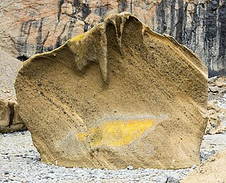
Tephrochronology is a geochronological technique that uses discrete layers of tephra—volcanic ash from a single eruption—to create a chronological framework in which paleoenvironmental or archaeological records can be placed. Such an established event provides a "tephra horizon". The premise of the technique is that each volcanic event produces ash with a unique chemical "fingerprint" that allows the deposit to be identified across the area affected by fallout. Thus, once the volcanic event has been independently dated, the tephra horizon will act as time marker. It is a variant of the basic geological technique of stratigraphy.

In geology, a bed is a layer of sediment, sedimentary rock, or volcanic rock "bounded above and below by more or less well-defined bedding surfaces". Specifically in sedimentology, a bed can be defined in one of two major ways. First, Campbell and Reineck and Singh use the term bed to refer to a thickness-independent layer comprising a coherent layer of sedimentary rock, sediment, or pyroclastic material bounded above and below by surfaces known as bedding planes. By this definition of bed, laminae are small beds that constitute the smallest (visible) layers of a hierarchical succession and often, but not always, internally comprise a bed.
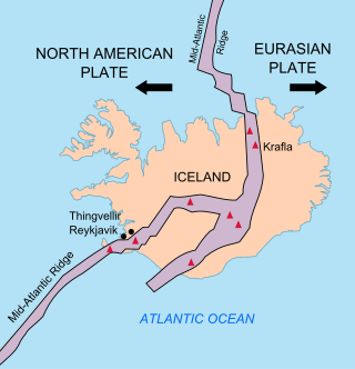
The geology of Iceland is unique and of particular interest to geologists. Iceland lies on the divergent boundary between the Eurasian plate and the North American plate. It also lies above a hotspot, the Iceland plume. The plume is believed to have caused the formation of Iceland itself, the island first appearing over the ocean surface about 16 to 18 million years ago. The result is an island characterized by repeated volcanism and geothermal phenomena such as geysers.
Nemo Peak is a stratovolcano located at the northern end of Onekotan Island, Kuril Islands, Russia. It is truncated by two nested calderas, with the cone of Nemo Peak itself rising in the southwest end of the youngest caldera and a crater lake partially filling the northeast part, named Ozero Chernoye.

Reclus, also written as Reclús, is a volcano located in the Southern Patagonian Ice Field, Chile. Part of the Austral Volcanic Zone of the Andes, its summit rises 1,000 metres (3,300 ft) above sea level and is capped by a crater about 1 kilometre (0.62 mi) wide. Close to the volcano lies the Amalia Glacier, which is actively eroding Reclus.
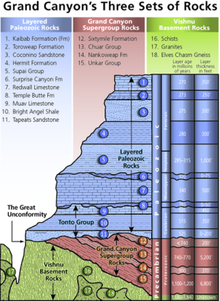
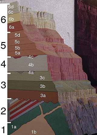
A stratigraphic column is a representation used in geology and its subfield of stratigraphy to describe the vertical location of rock units in a particular area. A typical stratigraphic column shows a sequence of sedimentary rocks, with the oldest rocks on the bottom and the youngest on top.
Marker horizons are stratigraphic units of the same age and of such distinctive composition and appearance, that, despite their presence in separate geographic locations, there is no doubt about their being of equivalent age (isochronous) and of common origin. Such clear markers facilitate the correlation of strata, and used in conjunction with fossil floral and faunal assemblages and paleomagnetism, permit the mapping of land masses and bodies of water throughout the history of the earth. They usually consist of a relatively thin layer of sedimentary rock that is readily recognized on the basis of either its distinct physical characteristics or fossil content and can be mapped over a very large geographic area. As a result, a key bed is useful for correlating sequences of sedimentary rocks over a large area. Typically, key beds were created as the result of either instantaneous events or very short episodes of the widespread deposition of a specific types of sediment. As the result, key beds often can be used for both mapping and correlating sedimentary rocks and dating them. Volcanic ash beds and impact spherule beds, and specific megaturbidites are types of key beds created by instantaneous events. The widespread accumulation of distinctive sediments over a geologically short period of time have created key beds in the form of peat beds, coal beds, shell beds, marine bands, black shales in cyclothems, and oil shales. A well-known example of a key bed is the global layer of iridium-rich impact ejecta that marks the Cretaceous–Paleogene boundary.
The Mazama Ash is an extensive, geologically recent deposit of volcanic ash that is present throughout much of northern North America. The ash was ejected from Mount Mazama, a volcano in south-central Oregon, during its climactic eruption about 7640 ± 20 years ago when Crater Lake was formed by caldera collapse. The ash spread primarily to the north and east due to the prevailing winds, and remnants of the ash have been identified as far northeast as the Greenland ice sheet.

The Campanian Ignimbrite eruption was a major volcanic eruption in the Mediterranean during the late Quaternary, classified 7 on the Volcanic Explosivity Index (VEI). The event has been attributed to the Archiflegreo volcano, the 12-by-15-kilometre-wide caldera of the Phlegraean Fields, located 20 km (12 mi) west of Mount Vesuvius under the western outskirts of the city of Naples and the Gulf of Pozzuoli, Italy. Estimates of the date and magnitude of the eruption(s), and the amount of ejected material have varied considerably during several centuries the site has been studied. This applies to most significant volcanic events that originated in the Campanian Plain, as it is one of the most complex volcanic structures in the world. However, continued research, advancing methods, and accumulation of volcanological, geochronological, and geochemical data have improved the dates' accuracy.

The Kulshan caldera is a Pleistocene volcano in the North Cascades of Washington and one of the few calderas identified in the entire Cascade Range. It is the product of the Mount Baker volcanic field, which has a history stretching back to possibly 3.722 million years ago.

Mount Berlin is a 3,478 metres (11,411 ft) high glacier-covered volcano in Marie Byrd Land, Antarctica, 210 kilometres (130 mi) from the Amundsen Sea. It is a c. 20-kilometre-wide (12 mi) mountain with parasitic vents that consists of two coalesced volcanoes; Berlin proper with the 2 kilometres (1.2 mi) wide Berlin Crater and Merrem Peak with a 2.5 by 1 kilometre wide crater, 3.5 kilometres (2.2 mi) away from Berlin. Trachyte is the dominant volcanic rock and occurs in the form of lava flows and pyroclastic rocks. It has a volume of 2,000 km3 (500 cu mi) and rises from the West Antarctic Ice Sheet. It is part of the Marie Byrd Land Volcanic Province.
