Bed (geology)

Last updated
Beds of sedimentary rock at Parque Geologico do Varvito, Itu, Sao Paulo, Brazil Webysther 20211009102044 - Parque Geologico do Varvito.jpg
Beds of sedimentary rock at Parque Geológico do Varvito, Itu, São Paulo, Brazil
Originally horizontal beds of sedimentary rock were tilted by the Alpine orogeny, at Angles, Alpes-de-Haute-Provence, France StratotypeBarremienA.JPG
Originally horizontal beds of sedimentary rock were tilted by the Alpine orogeny, at Angles, Alpes-de-Haute-Provence, France

In geology, a bed is a layer of sediment, sedimentary rock, or volcanic rock "bounded above and below by more or less well-defined bedding surfaces". [1] Specifically in sedimentology, a bed can be defined in one of two major ways. [2] First, Campbell [3] and Reineck and Singh [4] use the term bed to refer to a thickness-independent layer comprising a coherent layer of sedimentary rock, sediment, or pyroclastic material bounded above and below by surfaces known as bedding planes. By this definition of bed, laminae are small beds that constitute the smallest (visible) layers of a hierarchical succession and often, but not always, internally comprise a bed. [2]

Contents

Alternatively, a bed can be defined by thickness where a bed is a coherent layer of sedimentary rock, sediment, or pyroclastic material greater than 1 cm thick and a lamina is a coherent layer of sedimentary rock, sediment, or pyroclastic material less than 1 cm thick. [5] This method of defining bed versus lamina is frequently used in textbooks, e.g., Collinson & Mountney [6] or Miall. [7] Both definitions have merit and the choice of which one to use will depend on the focus of the specific study on a case by case basis. [2]

In geology, a bedding surface is either a planar, nearly planar, to wavy or curved 3-dimensional surface that visibly separates each successive bed (of the same or different lithology) from the preceding or following bed. Where bedding surfaces occur as cross-sections, e.g., in a 2-dimensional vertical cliff face of horizontal strata, are often referred to as bedding contacts. Within conformable successions, each bedding surface acted as the depositional surface for the accumulation of younger sediment. [1] [2]

Typically, but not always, bedding surfaces record changes in either the rate or type of accumulating sediment that created the underlying bed. Typically, they represent either a period of nondeposition, erosional truncation, shift in flow or sediment regime, abrupt change in composition, or combination of these as a result of changes in environmental conditions. As a result, a bed is typically, but not always, interpreted to represent a single period of time when sediments or pyroclastic material accumulated during uniform and steady paleoenvironmental conditions. However, some bedding surfaces may be postdepositional features either formed or enhanced by diagenetic processes or weathering. [2] [8]

The relationship between bedding surfaces controls the gross geometry of a bed. Most commonly, the bottom and top surfaces of beds are subparallel to parallel to each other. However, some bedding surfaces of a bed are nonparallel, e.g., wavy, or curved. Differing combinations of nonparallel bedding surfaces results in beds of widely varying geometric shapes such as uniform-tabular, tabular-lenticular, curved-tabular, wedge-shaped, and irregular beds. [9]

Types of beds include cross-beds and graded beds. Cross-beds, or "sets," are not layered horizontally and are formed by a combination of local deposition on the inclined surfaces of ripples or dunes, and local erosion. Graded beds show a gradual change in grain or clast sizes from one side of the bed to the other. A normal grading occurs where there are larger grain sizes on the older side, while an inverse grading occurs where there are smaller grain sizes on the older side. [4] [6] [9]

Bed thickness

Beds of lava flows exposed in Chasm Provincial Park, British Columbia, Canada Chasm Provincial Park trees and flood basalts.jpg
Beds of lava flows exposed in Chasm Provincial Park, British Columbia, Canada

Bed thickness is a basic and important characteristic of beds. Besides mapping stratigraphic units and interpreting sedimentary facies, the analysis of bed thickness can be used to recognize breaks in sedimentation, cyclic sedimentation patterns, and gradual environmental changes. [10] Such sedimentological studies are typically based on the hypothesis that the thicknesses of stratigraphic units follows a lognormal distribution. [10] [11] Differing nomenclatures for the bed and laminae thickness have been proposed by various authors, including McKee and Weir, [5] Ingram, [12] and Reineck and Singh. [4] However, none of them have been universally accepted by Earth scientists. [10] [13] In the practice of engineering geology, a standardized nomenclature is used for describing bed thickness in Australia, [14] European Union, [15] and United Kingdom. [16]

Examples of widely used bed thickness classifications include Tucker (1982) [17] and McKee and Weir [5] (1953).

Classification of Thickness of Stratification
Bedding classTucker (1982) [17] McKee and Weir [5] (1953)
Very thick> 1 m> 120 cm
Thick30 cm – 1 m60–120 cm
Medium10 – 30 cm
Thin3 – 10 cm5–60 cm
Very thin1 – 3 cm1–5 cm
Thickly laminated3 – 10 mm2 mm - 1 cm
Thinly laminated< 3 mm< 2 mm

Bed in lithostratigraphy

According to both the North American Stratigraphic Code and International Stratigraphic Guide, a bed is the smallest formal lithostratigraphic unit that can be used for sedimentary rocks. A bed, a stratum, is the smallest formal unit in the hierarchy of sedimentary lithostratigraphic units and is lithologically distinguishable from other layers above and below. Customarily, only distinctive beds, i.e. key beds, marker beds, that are particularly useful for stratigraphic purposes are given proper names and considered formal lithostratigraphic units. [18] [19]

In case of volcanic rocks, the lithostratigraphic unit equivalent to a bed is a flow. A flow is “...a discrete, extrusive, volcanic rock body distinguishable by texture, composition, order of superposition, paleomagnetism, or other objective criteria.” A flow is a part of a member as a bed of sedimentary rock is a part of a member. [18] [19]

Engineering considerations

In geotechnical engineering a bedding surface often forms a discontinuity that may have a large influence on the mechanical behaviour (strength, deformation, etc.) of soil and rock masses in tunnel, foundation, or slope construction.

Geologic principles

Vertical cross-sections of bed sequences to illustrate (from top to bottom) the Law of Superposition, the Law of Original Horizontality, the Law of Lateral Continuity, and Cross-Cutting Relationship Geologic Principles.jpg
Vertical cross-sections of bed sequences to illustrate (from top to bottom) the Law of Superposition, the Law of Original Horizontality, the Law of Lateral Continuity, and Cross-Cutting Relationship

These are the principles which apply to all geologic features, and can be used to describe the order of events in a feature's geologic history.

See also

Related Research Articles

<span class="mw-page-title-main">Sedimentary rock</span> Rock formed by the deposition and subsequent cementation of material

Sedimentary rocks are types of rock that are formed by the accumulation or deposition of mineral or organic particles at Earth's surface, followed by cementation. Sedimentation is the collective name for processes that cause these particles to settle in place. The particles that form a sedimentary rock are called sediment, and may be composed of geological detritus (minerals) or biological detritus. The geological detritus originated from weathering and erosion of existing rocks, or from the solidification of molten lava blobs erupted by volcanoes. The geological detritus is transported to the place of deposition by water, wind, ice or mass movement, which are called agents of denudation. Biological detritus was formed by bodies and parts of dead aquatic organisms, as well as their fecal mass, suspended in water and slowly piling up on the floor of water bodies. Sedimentation may also occur as dissolved minerals precipitate from water solution.

Sedimentology encompasses the study of modern sediments such as sand, silt, and clay, and the processes that result in their formation, transport, deposition and diagenesis. Sedimentologists apply their understanding of modern processes to interpret geologic history through observations of sedimentary rocks and sedimentary structures.

<span class="mw-page-title-main">Stratigraphy</span> Study of rock layers and their formation

Stratigraphy is a branch of geology concerned with the study of rock layers (strata) and layering (stratification). It is primarily used in the study of sedimentary and layered volcanic rocks. Stratigraphy has three related subfields: lithostratigraphy, biostratigraphy, and chronostratigraphy.

<span class="mw-page-title-main">Lithology</span> Description of its physical characteristics of a rock unit

The lithology of a rock unit is a description of its physical characteristics visible at outcrop, in hand or core samples, or with low magnification microscopy. Physical characteristics include colour, texture, grain size, and composition. Lithology may refer to either a detailed description of these characteristics, or a summary of the gross physical character of a rock. Examples of lithologies in the second sense include sandstone, slate, basalt, or limestone.

<span class="mw-page-title-main">Unconformity</span> Rock surface indicating a gap in the geological record

An unconformity is a buried erosional or non-depositional surface separating two rock masses or strata of different ages, indicating that sediment deposition was not continuous. In general, the older layer was exposed to erosion for an interval of time before deposition of the younger layer, but the term is used to describe any break in the sedimentary geologic record. The significance of angular unconformity was shown by James Hutton, who found examples of Hutton's Unconformity at Jedburgh in 1787 and at Siccar Point in Berwickshire in 1788, both in Scotland.

<span class="mw-page-title-main">Stratum</span> Layer of sedimentary rock or soil with internally consistent characteristics

In geology and related fields, a stratum is a layer of rock or sediment characterized by certain lithologic properties or attributes that distinguish it from adjacent layers from which it is separated by visible surfaces known as either bedding surfaces or bedding planes. Prior to the publication of the International Stratigraphic Guide, older publications have defined a stratum as either being either equivalent to a single bed or composed of a number of beds; as a layer greater than 1 cm in thickness and constituting a part of a bed; or a general term that includes both bed and lamina.
<span class="mw-page-title-main">Geological formation</span> Fundamental unit of lithostratigraphy

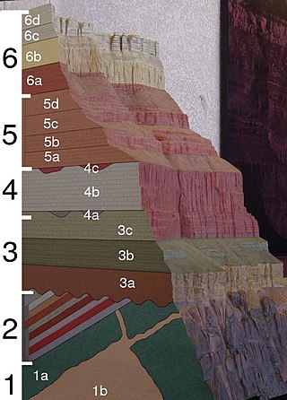
A geological formation, or simply formation, is a body of rock having a consistent set of physical characteristics (lithology) that distinguishes it from adjacent bodies of rock, and which occupies a particular position in the layers of rock exposed in a geographical region. It is the fundamental unit of lithostratigraphy, the study of strata or rock layers.

<span class="mw-page-title-main">Conglomerate (geology)</span> Coarse-grained sedimentary rock composed mostly of rounded to sub-angular fragments

Conglomerate is a clastic sedimentary rock that is composed of a substantial fraction of rounded to subangular gravel-size clasts. A conglomerate typically contains a matrix of finer-grained sediments, such as sand, silt, or clay, which fills the interstices between the clasts. The clasts and matrix are typically cemented by calcium carbonate, iron oxide, silica, or hardened clay.

A stratigraphic unit is a volume of rock of identifiable origin and relative age range that is defined by the distinctive and dominant, easily mapped and recognizable petrographic, lithologic or paleontologic features (facies) that characterize it.

<span class="mw-page-title-main">Lithostratigraphy</span> Sub-discipline of stratigraphy

Lithostratigraphy is a sub-discipline of stratigraphy, the geological science associated with the study of strata or rock layers. Major focuses include geochronology, comparative geology, and petrology.

<span class="mw-page-title-main">Roxbury Conglomerate</span>

The Roxbury Conglomerate, also informally known as Roxbury puddingstone, is a name for a rock formation that forms the bedrock underlying most of Roxbury, Massachusetts, now part of the city of Boston. The bedrock formation extends well beyond the limits of Roxbury, underlying part or all of Quincy, Canton, Milton, Dorchester, Dedham, Jamaica Plain, Brighton, Brookline, Newton, Needham, and Dover. It is named for exposures in Roxbury, Boston area.
<span class="mw-page-title-main">Cross-bedding</span> Sedimentary rock strata at differing angles

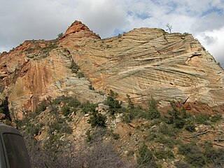
In geology, cross-bedding, also known as cross-stratification, is layering within a stratum and at an angle to the main bedding plane. The sedimentary structures which result are roughly horizontal units composed of inclined layers. The original depositional layering is tilted, such tilting not being the result of post-depositional deformation. Cross-beds or "sets" are the groups of inclined layers, which are known as cross-strata.

<span class="mw-page-title-main">Graded bedding</span> Type of layering in sediment or sedimentary rock

In geology, a graded bed is one characterized by a systematic change in grain or clast size from one side of the bed to the other. Most commonly this takes the form of normal grading, with coarser sediments at the base, which grade upward into progressively finer ones. Such a bed is also described as fining upward. Normally graded beds generally represent depositional environments which decrease in transport energy as time passes, but these beds can also form during rapid depositional events. They are perhaps best represented in turbidite strata, where they indicate a sudden strong current that deposits heavy, coarse sediments first, with finer ones following as the current weakens. They can also form in terrestrial stream deposits.

<span class="mw-page-title-main">Sedimentary structures</span> Geologic structures formed during sediment deposition

Sedimentary structures include all kinds of features in sediments and sedimentary rocks, formed at the time of deposition.
<span class="mw-page-title-main">Stratigraphic column</span>

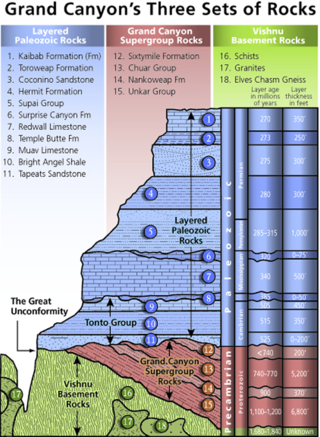
A stratigraphic column is a representation used in geology and its subfield of stratigraphy to describe the vertical location of rock units in a particular area. A typical stratigraphic column shows a sequence of sedimentary rocks, with the oldest rocks on the bottom and the youngest on top.

<span class="mw-page-title-main">Mudcrack</span> Pattern of cracks in dried muddy soil

Mudcracks are sedimentary structures formed as muddy sediment dries and contracts. Crack formation also occurs in clay-bearing soils as a result of a reduction in water content.

<span class="mw-page-title-main">Lamination (geology)</span> Thin layers present in sedimentary rock

In geology, lamination is a small-scale sequence of fine layers that occurs in sedimentary rocks. Laminae are normally smaller and less pronounced than bedding. Lamination is often regarded as planar structures one centimetre or less in thickness, whereas bedding layers are greater than one centimetre. However, structures from several millimetres to many centimetres have been described as laminae. A single sedimentary rock can have both laminae and beds.

A geological contact is a boundary which separates one rock body from another. A contact can be formed during deposition, by the intrusion of magma, or through faulting or other deformation of rock beds that brings distinct rock bodies into contact.

<span class="mw-page-title-main">Gai-As Formation</span>

The Gai-As Formation is an Early to Middle Permian geologic formation correlated with the Ecca Group and designated "Ecca" Group, because it does not belong to the Karoo, in the southwestern Kunene Region and northern Erongo Region of northwestern Namibia. The Gai-As Formation represents the second-oldest sedimentary unit of the Huab Basin, overlying the Huab Formation. The formation was deposited in a fluvial to lacustrine setting.

Geological perspective correlation is a theory in geology describing geometrical regularities in the layering of sediments. Seventy percent of the Earth's surface are occupied by sedimentary basins – volumes consisted of sediments accumulated during million years, and alternated by long interruptions in sedimentation (hiatuses). The most noticeable feature of the rocks, which filled the basins, is layering (stratification). Stratigraphy is a part of Geology that investigates the phenomenon of layering. It describes the sequence of layers in the basin as consisted of stratigraphic units. Units are defined on the basis of their lithology and have no clear definition. Geological Perspective Correlation (GPC) is a theory that divided the geological cross-section in units according strong mathematical rule: all borders of layers in this unit obey the law of perspective geometry.
Sedimentation layers are mainly created in shallow waters of oceans, seas, and lakes. As new layers are deposited the old ones are sinking deeper due to the weight of accumulating sediments. The content of sedimentary layers, their order in the sequence, and geometrical characteristics keep records of the history of the Earth, of past climate, sea-level and environment. Most knowledge about the sedimentary basins came from exploration drilling when searching for oil and gas. The essential feature of this information is that each layer is penetrated by the wells in a number of scattered locations. This raises the problem of identifying each layer in all wells – the geological correlation problem The identification is based on comparison of 1) physical and mineralogical characteristics of the particular layer (lithostratigraphy), or 2) petrified remnants in this layer (biostratigraphy). The similarity of layers is decreasing as the distance between the cross-sections increases that leads to ambiguity of the correlation scheme that indicates which layers penetrated at different locations belong to the same body. To improve the results geologists take in consideration the spatial relations between layers, which restricted the number of acceptable correlations. The first restriction was formulated in XVII century: the sequence of layers is the same in any cross-section. The second one was discovered by Haites in 1963: In an undisturbed sequence of layers (strata) the thicknesses of any layer observed in two different locations obey the law of perspective geometry, i.e. the perspective ratio K = H1/H2 is the same for all layers in this succession. This theory attracted attention around the world., and particularly in Russia The theory is also a basis of the method of graphical correlation in biostratigraphy widely used in oil and coal industries.

References

  1. 1 2 Neuendorf, K.K.E., J.P. Mehl, Jr., and J.A. Jackson, eds., 2005. Glossary of Geology (5th ed.). Alexandria, Virginia; American Geological Institute. p 61. ISBN   0-922152764
  2. 1 2 3 4 5 Davies, N.S., and Shillito, A.P. 2021, True substrates: the exceptional resolution and unexceptional preservation of deep time snapshots on bedding surfaces.Sedimentology. published online 22 May 2021, doi: 10.1111/sed.12900.
  3. Campbell, Charles V. (February 1967). "Lamina, Laminaset, Bed and Bedset". Sedimentology. 8 (1): 7–26. Bibcode:1967Sedim...8....7C. doi:10.1111/j.1365-3091.1967.tb01301.x via Wiley Online Library.
  4. 1 2 3 Reineck, H.E., and Singh, I.B., 1980. Depositional Sedimentary Environments, (2nd ed.) Berlin, Germany: Springer-Verlag, 504 pp. ISBN   978-3642962912
  5. 1 2 3 4 McKee, Edwin D.; Weir, Gordon W. (1953). "Terminology for Stratification and Cross-Stratification in Sedimentary Rock". Bulletin of the Geological Society of America. Geological Society of America. 64 (4): 381–390. Bibcode:1953GSAB...64..381M. doi:10.1130/0016-7606(1953)64[381:TFSACI]2.0.CO;2 via GeoScienceWorld.
  6. 1 2 Collinson, J., and Mountney, N., 2019. Sedimentary Structures, (4th ed.) Edinburgh, Scotland, Dunedin Academic Press, 320 pp. ISBN   978-1903544198
  7. Miall, A.D., 2016. Stratigraphy: A Modern Synthesis. Dordrecht, Netherlands: Springer. 454 pp. ISBN   978-3319243023
  8. Davies, N.S., and Shillito, A.P. 2018, Incomplete but intricately detailed: the inevitable preservation of true substrates in a time-deficient stratigraphic record.Geology, 46, pp. 679–682.
  9. 1 2 Boggs, Jr., Sam (2006). Principles of Sedimentology and Stratigraphy (PDF) (4th ed.). Upper Saddle River, NJ: Prentice Hall. ISBN   0-13-154728-3.
  10. 1 2 3 Flügel, E. and Munnecke, A., 2010. Microfacies of carbonate rocks: analysis, interpretation and application. Berlin, Germany, Springer-Verlag, 2004 pp. ISBN   978-3662499610
  11. Lumsden, D.N., 1971. Facies and bed thickness distributions of limestones. Journal of Sedimentary Research, 41(2), pp.593-598.
  12. Ingram, R.L., 1954. Terminology for the thickness of stratification and parting units in sedimentary rocks. Geological Society of America Bulletin, 65(9), pp. 937-938.
  13. Kelley, V.C., 1956. Thickness of strata. Journal of Sedimentary Research, 26(4), pp.289-300.
  14. Australian Standards, 1993. Geotechnical site investigations. AS1726 – 1993. Sydney, Australia: Standards Association of Australia, 40 pp.
  15. International Organization for Standardization, 2017. 14689:2017 Geotechnical investigation and testing — Identification, description and classification of rock. Geneva, Switzerland: International Organization for Standardization. 122 pp.
  16. British Standards Institution, 2015. BS 5930:2015 Code of practice for ground investigations. London, England: British Standards Institution. 317 pp. ISBN   978-0580800627
  17. 1 2 Tucker, Maurice, E. 1982. The Field Description of Sedimentary Rocks. Geological Society of London Handbook, Open University Press, Milton Keynes, UK, and John Wiley & Sons, NY. Table 5.2, p. 48.
  18. 1 2 Murphy, M.A., and Salvador, A., 1999. International stratigraphic guide—an abridged version. Episodes. 22(4), pp.255-272.
  19. 1 2 North American Commission on Stratigraphic Nomenclature, 2021. North American Stratigraphic Code. Stratigraphy. 18(3), pp.153–204.
  20. 1 2 Steno, Nicolaus (1671). The Prodromus to a Dissertation Concerning Solids Naturally Contained within Solids: Laying a Foundation for the Rendering a Rational Attempt both of the Frame and the several Changes of the Masse of the Earth, as also of the various Productions in the same. Translated by Oldenburg, Henry (2nd ed.). London: F. Winter via Biodiversity Heritage Library.
  21. Levin, Harold L. (2009). The Earth Through Time. John Wiley & Sons, Inc. p. 15. ISBN   978-0-470-38774-0.