Hurricane hunters

Last updated
A NOAA WP-3D Orion weather reconnaissance aircraft Lockheed WP-3D Orion.jpg
A NOAA WP-3D Orion weather reconnaissance aircraft

Hurricane hunters, typhoon hunters, or cyclone hunters are aircrews that fly into tropical cyclones to gather weather data. In the United States, the organizations that fly these missions are the United States Air Force Reserve's 53rd Weather Reconnaissance Squadron and the National Oceanic and Atmospheric Administration's Hurricane Hunters. Such missions have also been flown by Navy units and other Air Force and NOAA units. Other organizations also fly these missions, such as Government Flying Service Hong Kong.

Contents

The first crewed flight into a hurricane happened in 1943 when a pilot-trainer flew into a Category 1 hurricane near Galveston, Texas on a bet. [1]

In the past, before satellites were used to find tropical storms, military aircraft flew routine weather reconnaissance tracks to detect formation of tropical cyclones. While modern satellites have improved the ability of meteorologists to detect cyclones before they form, only aircraft are able to measure the interior barometric pressure of a hurricane and provide accurate wind speed data, information needed to accurately predict hurricane development and movement.

Units

USAFR 53rd WRS

The Air Force Reserve 53rd Weather Reconnaissance Squadron, the world's only operational military weather reconnaissance unit, is based at Keesler Air Force Base in Biloxi, Mississippi; most weather recon flights originate there. The term "hurricane hunters" was first applied to its missions in 1946.

The USAFR hurricane hunters fly weather missions in an area midway through the Atlantic Ocean to the Hawaiian Islands, and have on occasion flown into typhoons in the Pacific Ocean and gathered data in winter storms.

The 53rd WRS hurricane hunters operate ten Lockheed WC-130J aircraft, which fly directly into hurricanes, typically penetrating the hurricane's eye several times per mission at altitudes between 500 feet (150 m) and 10,000 feet (3,000 m).

NOAA Hurricane Hunters

The civilian and NOAA Corps crew members of the NOAA Hurricane Hunters, originally based at the Aircraft Operations Center at MacDill AFB, in Tampa, Florida, mainly perform surveillance, research, and reconnaissance with highly instrumented aircraft including airborne Doppler weather radar measurements in both Atlantic and Pacific storms. In June 2017 [2] [3] the Hunters moved into a new facility at Lakeland Linder International Airport in Lakeland, Florida, after being at MacDill since 1993. They fly two Lockheed WP-3D Orion aircraft, heavily instrumented flying laboratories modified to take atmospheric and radar measurements within tropical cyclones and winter storms, and a G-IV Gulfstream high-altitude jet above 41,000 feet (12 km) to document upper- and lower-level winds that affect cyclone movement. The computer models that forecast hurricane tracks and intensity mainly use G-IV dropsonde data collected day and night in storms affecting the United States.

Government Flying Service Hong Kong

Since 2009 the Government Flying Service of Hong Kong (GFS) have conducted regular flight data collection in cooperation with the Hong Kong Observatory. In 2011, the cooperation between GFS and the Observatory extended to reconnaissance flights to capture weather data for tropical cyclones over the South China Sea. [4] In September 2016 they introduced the dropsonde system, which collects extra meteorological data on tropical cyclones to enhance the monitoring of typhoons. [5]

History

View of the eyewall of Hurricane Katrina taken on August 28, 2005, by a NOAA P-3. Hurricane Katrina Eye viewed from Hurricane Hunter.jpg
View of the eyewall of Hurricane Katrina taken on August 28, 2005, by a NOAA P-3.

Among the types of aircraft that have been used to investigate hurricanes, are an instrumented Lockheed U-2 flown in Hurricane Ginny during the 1963 Atlantic hurricane season. Other types include the A-20 Havoc, 1944; B-24, 1944–1945; B-17, 1945–1947; B-25, 1946–1947; B-29, 1946–1947. WB-29, 1951–1956; WB-50, 1956–1963; WB-47, 1963–1969; WC-121N 1954–1973; WC-130A, B, E, H, 1965–2012.

The idea of aircraft reconnaissance of hurricane storm trackers was put forth by Captain W. L. Farnsworth of the Galveston Commercial Association in the early 1930s. Supported by the United States Weather Bureau, the "storm patrol bill" passed both the United States Senate and United States House of Representatives on June 15, 1936. [6]

1935 Labor Day Hurricane

The first time a reconnaissance flight took place with the sole purpose of locating a hurricane was during the 1935 Great Labor Day Hurricane, which would later become the strongest storm to ever impact the U.S.

On September 1, the storm moved through The Bahamas where it was estimated to be at hurricane strength. As a result, ships began to avoid the Florida Straight, depriving the Weather Bureau of valuable information. This led to confusion as the Weather Bureau believed it would continue on its westward parth and make landfall in Cuba while the Cuba weather service didn't see any evidence for this.

On September 2, a pilot flying over the Florida Keys noticed a large cloud mass to the east and more north than it should have been. The Cuban weather service requested a plane to be sent up to find the storm, with Captain Leonard Povey volunteering. After circling, but not penetrating (his plane had an open cockpit), the storm, he confirmed the storm was located more north than originally thought and actually heading northeast. This was relayed to the Weather Bureau, which immediately put warnings out for the Florida Keys. The storm would make landfall later that day.

Capt. Povey urged Congress and the Weather Bureau to implement full-time reconnaissance planes, but to no avail. A plan was laid out to use Coast Guard cutters, but was never implemented. [7]

1943 Surprise Hurricane

The 1943 Surprise Hurricane, which struck Houston, Texas, during World War II, marked the first intentional meteorological flight into a hurricane. It started with a bet.

That summer, British pilots were being trained in instrument flying at Bryan Field. When they saw that the Americans were evacuating their AT-6 Texan trainers in the face of the storm, they began questioning the construction of the aircraft. Lead instructor Colonel Joe Duckworth took one of the trainers out and flew it straight into the eye of the storm. After he returned safely with navigator Lt. Ralph O'Hair, the base's weather officer, Lt. William Jones-Burdick, took over the navigator's seat and Duckworth flew into the storm a second time. [8] [9]

This flight showed that hurricane reconnaissance flights were possible, and further flights continued occasionally. In 1946, the moniker "Hurricane Hunters" was first used, and the Air Force and now Air Force Reserve have used it ever since. The flights demonstrated that hurricane reconnaissance flights were feasible. [10] [11]

VW-4

Lockheed WP-3A Orion weather reconnaissance aircraft of VW-4 Squadron at its NAS Jacksonville Florida base in 1974 Lockheed P-3 WP-3A 150496 VW-4 JAX 06.74 edited-2.jpg
Lockheed WP-3A Orion weather reconnaissance aircraft of VW-4 Squadron at its NAS Jacksonville Florida base in 1974

The United States Navy's VW-4 / WEARECORON FOUR Weather Reconnaissance Squadron Four, "Hurricane Hunters" was the seventh U.S. Navy squadron dedicated to weather reconnaissance. They flew several types of aircraft, but the WC-121N "Willy Victor" was the aircraft most often associated with flying into the "eye of the storm." The squadron operated WC-121s between late 1954 and 1972. [12] VW-4 lost one aircraft and crew in a penetration of Hurricane Janet, [13] and another to severe damage in a storm, but the severely damaged Willy Victor (MH-1) brought her crew home, although she never flew again. During 1973–1975, VW-4 operated the turbine-propeller Lockheed WP-3A Orion.

Hurricane Katrina

The landfall of Hurricane Katrina on 29 August 2005 devastated Keesler Air Force Base, home of the 53rd WRS. The equipment and personnel of the squadron were flying out of Dobbins Air Reserve Base near Atlanta. Despite heavy equipment losses, the squadron never missed a mission from the National Hurricane Center. The 53rd has since returned to Keesler.

Aircraft losses

Other incidents

A reality television series featuring the USAFR 53rd WRS, entitled Hurricane Hunters, debuted on The Weather Channel in July 2012. [24]

The story of the NOAA flight during Hurricane Hugo was shown as part of the Mayday television show on the during 2015. [25]

See also

Related Research Articles

<span class="mw-page-title-main">Project Stormfury</span> NOAA weather modification program.

Project Stormfury was an attempt to weaken tropical cyclones by flying aircraft into them and seeding with silver iodide. The project was run by the United States Government from 1962 to 1983. The hypothesis was that the silver iodide would cause supercooled water in the storm to freeze, disrupting the inner structure of the hurricane, and this led to seeding several Atlantic hurricanes. However, it was later shown that this hypothesis was incorrect. It was determined that most hurricanes do not contain enough supercooled water for cloud seeding to be effective. Additionally, researchers found that unseeded hurricanes often undergo the same structural changes that were expected from seeded hurricanes. This finding called Stormfury's successes into question, as the changes reported now had a natural explanation.

<span class="mw-page-title-main">Lockheed WP-3D Orion</span> NOAA hurricane hunter aircraft


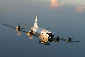
The Lockheed WP-3D Orion is a highly modified P-3 Orion used by the Aircraft Operations Center division of the National Oceanic and Atmospheric Administration (NOAA). Only two of these aircraft exist, each incorporating numerous features for the role of collecting weather information. During the Atlantic hurricane season, the WP-3Ds are deployed for duty as hurricane hunters. The aircraft also support research on other topics, such as Arctic ice coverage, air chemistry studies, and ocean water temperature and current analysis.

<span class="mw-page-title-main">Lockheed WC-130</span> Weather aircraft series by Lockheed

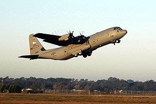
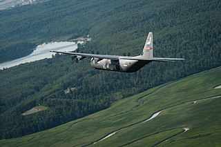
The Lockheed WC-130 is a high-wing, medium-range aircraft used for weather reconnaissance missions by the United States Air Force. The aircraft is a modified version of the C-130 Hercules transport configured with specialized weather instrumentation including a dropsonde deployment/receiver system and crewed by a meteorologist for penetration of tropical cyclones and winter storms to obtain data on movement, size and intensity.

<span class="mw-page-title-main">53rd Weather Reconnaissance Squadron</span> Military unit

The 53rd Weather Reconnaissance Squadron, also known by its nickname, Hurricane Hunters, is a flying unit of the United States Air Force, and "the only Department of Defense organization still flying into tropical storms and hurricanes." Aligned under the 403rd Wing of the Air Force Reserve Command (AFRC) and based at Keesler Air Force Base, Mississippi, with ten aircraft, it flies into tropical cyclones in the Atlantic Ocean, the Caribbean Sea, the Gulf of Mexico and the Central Pacific Ocean for the specific purpose of directly measuring weather data in and around those storms. The 53rd WRS currently operates the Lockheed WC-130J aircraft as its weather data collection platform.

<span class="mw-page-title-main">Keesler Air Force Base</span> US Air Force base in Biloxi, Mississippi

Keesler Air Force Base is a United States Air Force base located in Biloxi, a city along the Gulf Coast in Harrison County, Mississippi, United States. The base is named in honor of aviator 2d Lt Samuel Reeves Keesler Jr., a Mississippi native killed in France during the First World War. The base is home of Headquarters, Second Air Force and the 81st Training Wing of the Air Education and Training Command (AETC).

<span class="mw-page-title-main">Dropsonde</span>

A dropsonde is an expendable weather reconnaissance device created by the National Center for Atmospheric Research (NCAR), designed to be dropped from an aircraft at altitude over water to measure storm conditions as the device falls to the surface. The sonde contains a GPS receiver, along with pressure, temperature, and humidity (PTH) sensors to capture atmospheric profiles and thermodynamic data. It typically relays this data to a computer in the aircraft by radio transmission.

<span class="mw-page-title-main">Lockheed EC-121 Warning Star</span> Airborne early warning and control aircraft based on the Constellation airframe

The Lockheed EC-121 Warning Star was an American airborne early warning and control radar surveillance aircraft operational in the 1950s in both the United States Navy (USN) and United States Air Force (USAF).

<span class="mw-page-title-main">Consolidated PB4Y-2 Privateer</span> Patrol bomber of the US Navy, 1943

The Consolidated PB4Y-2 Privateer is an American World War II and Korean War era patrol bomber of the United States Navy derived from the Consolidated B-24 Liberator. The Navy had been using B-24s with only minor modifications as the PB4Y-1 Liberator, and along with maritime patrol Liberators used by RAF Coastal Command this type of patrol plane was proven successful. A fully navalised design was desired, and Consolidated developed a dedicated long-range patrol bomber in 1943, designated PB4Y-2 Privateer. In 1951, the type was redesignated P4Y-2 Privateer. A further designation change occurred in September 1962, when the remaining Navy Privateers were redesignated QP-4B.

<span class="mw-page-title-main">1971 Pacific hurricane season</span> Hurricane season in the Pacific Ocean

The 1971 Pacific hurricane season began on May 15, 1971 in the eastern Pacific, and on June 1, 1971 in the Central Pacific ; both ended on November 30, 1971. These dates, adopted by convention, historically describe the period in each year when most tropical cyclogenesis occurs in these regions of the Pacific. It was the first year that continuous Weather satellite coverage existed over the entire Central Pacific. As such, this season is often viewed as the start year for modern reliable tropical cyclone data in the Pacific Ocean.

<span class="mw-page-title-main">Typhoon Bess (1974)</span> Pacific typhoon in 1974

Typhoon Bess, known in the Philippines as Typhoon Susang, was responsible for the disappearance of a United States Air Force weather reconnaissance aircraft. Developing out of a poorly organized system on October 8 to the east of the Philippines, Bess featured two centers of circulation. Initially the southern low was monitored; however, a low to the north soon became the dominant center. Tracking generally west-northwestward, the storm gradually intensified before striking northern Luzon as a minimal typhoon on October 11. Temporary weakening took place due to interaction with land. After moving back over water the following morning, Bess regained typhoon intensity. This was short-lived though, as conditions surrounding the cyclone soon caused it to weaken. Now moving due west, the weakening storm eventually struck Hainan Island as a tropical storm on October 12 before diminishing to a tropical depression. The depression briefly moved back over water before dissipating in northern Vietnam on October 14.

<span class="mw-page-title-main">Tropical cyclone observation</span>

Tropical cyclone observation has been carried out over the past couple of centuries in various ways. The passage of typhoons, hurricanes, as well as other tropical cyclones have been detected by word of mouth from sailors recently coming to port or by radio transmissions from ships at sea, from sediment deposits in near shore estuaries, to the wiping out of cities near the coastline. Since World War II, advances in technology have included using planes to survey the ocean basins, satellites to monitor the world's oceans from outer space using a variety of methods, radars to monitor their progress near the coastline, and recently the introduction of unmanned aerial vehicles to penetrate storms. Recent studies have concentrated on studying hurricane impacts lying within rocks or near shore lake sediments, which are branches of a new field known as paleotempestology. This article details the various methods employed in the creation of the hurricane database, as well as reconstructions necessary for reanalysis of past storms used in projects such as the Atlantic hurricane reanalysis.

The Hurricane Research Division (HRD) is a section of the Atlantic Oceanographic and Meteorological Laboratory (AOML) in Miami, Florida, and is the U.S. National Oceanic and Atmospheric Administration's (NOAA) focus for tropical cyclone research. The thirty member division is not a part of the National Hurricane Center but cooperates closely with them in carrying out its annual field program and in transitioning research results into operational tools for hurricane forecasters. HRD was formed from the National Hurricane Research Laboratory in 1984, when it was transferred to AOML and unified with the oceanographic laboratories.

<span class="mw-page-title-main">920th Rescue Wing</span> Military unit

The 920th Rescue Wing is part of the Air Reserve Component (ARC) of the United States Air Force. The wing is assigned to the Tenth Air Force of the Air Force Reserve Command (AFRC).

<span class="mw-page-title-main">NOAA Hurricane Hunters</span> Group of aircraft maintained by the NOAA

The NOAA Hurricane Hunters are a group of aircraft used for hurricane reconnaissance by the United States National Oceanic and Atmospheric Administration (NOAA). They fly through hurricanes to help forecasters and scientists gather operational and research data. The crews also conduct other research projects including ocean wind studies, winter storm research, thunderstorm research, coastal erosion, and air chemistry flights.

<span class="mw-page-title-main">403rd Operations Group</span> Military unit

The 403rd Operations Group is the operational flying component of the United States Air Force Reserve 403rd Wing. It is stationed at Keesler Air Force Base, Mississippi.

<span class="mw-page-title-main">55th Space Weather Squadron</span> Inactive United States Air Force unit

The 55th Space Weather Squadron is an inactive United States Air Force unit. It was last assigned to the 50th Operations Group at Schriever Air Force Base, Colorado, where it was inactivated on 16 July 2002.

<span class="mw-page-title-main">54th Weather Reconnaissance Squadron</span> Military unit

The 54th Weather Reconnaissance Squadron is an inactive United States Air Force unit. Its last assignment was to the 41st Rescue and Weather Reconnaissance Wing at Andersen Air Force Base, Guam, where it was inactivated on 30 September 1987.

<span class="mw-page-title-main">Weather reconnaissance</span>

Weather reconnaissance is the acquisition of weather data used for research and planning. Typically the term reconnaissance refers to observing weather from the air, as opposed to the ground.

<span class="mw-page-title-main">Typhoon Nora (1973)</span> Pacific typhoon in 1973

Typhoon Nora, known in the Philippines as Typhoon Luming, was tied for the fourth-most intense tropical cyclone on record. Originating from an area of low pressure over the western Pacific, Nora was first identified as a tropical depression on October 2, 1973. Tracking generally westward, the system gradually intensified, attaining typhoon status the following evening. After turning northwestward, the typhoon underwent a period of rapid intensification, during which its central pressure decreased by 77 mb in 24 hours. At the end of this phase, Nora peaked with winds of 295 km/h (185 mph) and a pressure of 875 mb, making it the most-intense tropical cyclone on record at the time; however, this pressure has since been surpassed by Typhoon June, Typhoon Tip and Hurricane Patricia. The typhoon subsequently weakened and turned northwestward as it approached the Philippines. After brushing Luzon on October 7, the system passed south of Taiwan and ultimately made landfall in China on October 10. Once onshore, Nora quickly weakened and dissipated the following day.

<span class="mw-page-title-main">The Hurricane Rainband and Intensity Change Experiment</span> Project intending to improve hurricane forecasting

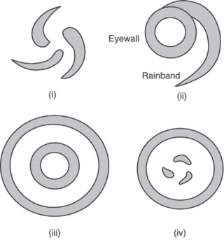
The Hurricane Rainband and Intensity Change Experiment (RAINEX) is a project to improve hurricane intensity forecasting via measuring interactions between rainbands and the eyewalls of tropical cyclones. The experiment was planned for the 2005 Atlantic hurricane season. This coincidence of RAINEX with the 2005 Atlantic hurricane season led to the study and exploration of infamous hurricanes Katrina, Ophelia, and Rita. Where Hurricane Katrina and Hurricane Rita would go on to cause major damage to the US Gulf coast, Hurricane Ophelia provided an interesting contrast to these powerful cyclones as it never developed greater than a Category 1.

References

Notes

  1. McMahon, Bucky (September 8, 2017). "Into the Eye of the Storm". Popular Mechanics. Archived from the original on August 9, 2020. Retrieved September 11, 2017.
  2. "NOAA hurricane center once housed at MacDill opens in Lakeland". Tampa Bay Times. Archived from the original on 2020-06-13. Retrieved 2020-11-15.
  3. "NOAA Hurricane Hunters Have New Home In Lakeland". WUSF Public Media. Archived from the original on 2020-11-27. Retrieved 2020-11-15.
  4. "Aircraft Meteorological Observation for Tropical Cyclones". www.hko.gov.hk. Archived from the original on 2022-07-05. Retrieved 2022-09-12.
  5. "HKO and GFS join forces to introduce dropsonde system". www.hko.gov.hk. Archived from the original on 2022-09-12. Retrieved 2022-09-12.
  6. Associated Press. "Storm Patrol Bill Passed to President" Hurricane Archive[ dead link ] Retrieved on 2008-06-06.
  7. "80th Anniversary of the Labor Day Hurricane and first hurricane reconnaissance". Hurricane Research Division. 2015-09-02. Archived from the original on 2023-06-10. Retrieved 2023-08-19 via Wordpress.
  8. Bob Sheets; Jack Williams (2001). Hurricane Watch: Forecasting the Deadliest Storms on Earth. Vintage. ISBN   0-375-70390-X., pp. 98–100
  9. Kaye, Ken (25 July 2013). "First 'hurricane hunter' flight was made on a bet". South Florida Sun-Sentinel. Archived from the original on 27 July 2013. Retrieved 27 July 2013.
  10. "53d Weather Reconnaissance Squadron 'Hurricane Hunters' Fact Sheet". 403rd Wing AFRC. Retrieved 2 September 2010.
  11. Fincher, Lew; Read, Bill. "The 1943 "Surprise" Hurricane". NOAA.gov. Retrieved 30 August 2010.
  12. Marson, 1982, p. 318
  13. Garland, Harlin (October 1966). "U. S. Navy Hurricane Hunters". ESSA World. Environmental Satellite Services Administration: 7.
  14. "The 6 lost Hurricane Hunter missions, Part I: the Oct 1, 1945 typhoon" Archived August 1, 2020, at the Wayback Machine Weather Underground Retrieved: 3 April 2020.
  15. "The 6 lost Hurricane Hunter missions, Part II: Typhoon Wilma, 1952" Archived 2020-08-01 at the Wayback Machine Weather Underground Retrieved: 3 April 2020.
  16. "The 6 lost Hurricane Hunter missions, Part III: Typhoon Doris, 1953" Archived 2020-08-01 at the Wayback Machine Weather Underground Retrieved: 3 April 2020.
  17. "The 6 lost Hurricane Hunter missions, Part IV: Hurricane Janet, 1955" Archived 2020-08-02 at the Wayback Machine Weather Underground Retrieved: 3 April 2020.
  18. "The 6 lost Hurricane Hunter missions, Part V: Typhoon Ophelia, 1958" Archived 2020-08-01 at the Wayback Machine Weather Underground Retrieved: 3 April 2020.
  19. Robison, Tom "Whiskey-Charlie!" Archived 2020-08-21 at the Wayback Machine Air Weather Reconnaissance Association website. Retrieved on 2008-09-26.
  20. Marks, Frank D.; Black, Peter G.; Montgomery, Michael T.; Burpee, Robert W. (April 2008). "Structure of the Eye and Eyewall of Hurricane Hugo (1989)". Monthly Weather Review. 136 (4). Boston, Massachusetts: American Meteorological Society: 1237–1259. Bibcode:2008MWRv..136.1237M. doi: 10.1175/2007MWR2073.1 . S2CID   52062413.
  21. "25th Anniversary of a 'hairy hop' into Hurricane Hugo". Hurricane Research Division. 15 September 2014. Retrieved 6 February 2024.
  22. NOAA Mishap Investigation Report (PDF) (Report). SkyBrary. August 9, 2007. Retrieved 6 February 2024.
  23. Ried, Jeffrey S.; Eleuterio, Daniel; Cook, B. J.; Walker, Annette L.; Richardson, Kim A.; Westphal, Douglas L.; Zhang, Jianglong; Damiano, A. B.; McNamara, Richard J. (October 25, 2007). An Assessment of the Meteorological Conditions Leading to the NOAA WP-3D Engine Compressor Stalls of February 9, 2007, Due to Sea Salt Aerosol Particle Fouling (Report). Retrieved February 6, 2024.
  24. "Official website for the TV series". Archived from the original on 2018-09-29. Retrieved 2013-01-29.
  25. "Smithsonian Channel: It's Brighter Here". Archived from the original on 2020-11-25. Retrieved 2020-12-08.

Bibliography