Extratropical cyclone

Last updated
A powerful extratropical cyclone over the North Atlantic Ocean in March 2022 Extratropical Cyclone over North Atlantic 2022-03-20.jpg
A powerful extratropical cyclone over the North Atlantic Ocean in March 2022

Extratropical cyclones, sometimes called mid-latitude cyclones or wave cyclones, are low-pressure areas which, along with the anticyclones of high-pressure areas, drive the weather over much of the Earth. Extratropical cyclones are capable of producing anything from cloudiness and mild showers to severe gales, thunderstorms, blizzards, and tornadoes. These types of cyclones are defined as large scale (synoptic) low pressure weather systems that occur in the middle latitudes of the Earth. In contrast with tropical cyclones, extratropical cyclones produce rapid changes in temperature and dew point along broad lines, called weather fronts, about the center of the cyclone. [1]

Contents

Terminology

This animation shows an extratropical cyclone developing over the United States, starting late on October 25 and running through October 27, 2010.

The term "cyclone" applies to numerous types of low pressure areas, one of which is the extratropical cyclone. The descriptor extratropical signifies that this type of cyclone generally occurs outside the tropics and in the middle latitudes of Earth between 30° and 60° latitude. They are termed mid-latitude cyclones if they form within those latitudes, or post-tropical cyclones if a tropical cyclone has intruded into the mid latitudes. [1] [2] Weather forecasters and the general public often describe them simply as "depressions" or "lows". Terms like frontal cyclone, frontal depression, frontal low, extratropical low, non-tropical low and hybrid low are often used as well.[ citation needed ]

Extratropical cyclones are classified mainly as baroclinic, because they form along zones of temperature and dewpoint gradient known as frontal zones. They can become barotropic late in their life cycle, when the distribution of heat around the cyclone becomes fairly uniform with its radius. [3]

Formation

Approximate areas of extratropical cyclone formation worldwide Extratropical formation areas.jpg
Approximate areas of extratropical cyclone formation worldwide
An upper-level jet streak. DIV areas are regions of divergence aloft, which will lead to surface convergence and aid cyclogenesis. Jetstreak.png
An upper-level jet streak. DIV areas are regions of divergence aloft, which will lead to surface convergence and aid cyclogenesis.

Extratropical cyclones form anywhere within the extratropical regions of the Earth (usually between 30° and 60° latitude from the equator), either through cyclogenesis or extratropical transition. In a climatology study with two different cyclone algorithms, a total of 49,745–72,931 extratropical cyclones in the Northern Hemisphere and 71,289–74,229 extratropical cyclones in the Southern Hemisphere were detected between 1979 and 2018 based on reanalysis data. [4] A study of extratropical cyclones in the Southern Hemisphere shows that between the 30th and 70th parallels, there are an average of 37 cyclones in existence during any 6-hour period. [5] A separate study in the Northern Hemisphere suggests that approximately 234 significant extratropical cyclones form each winter. [6]

Cyclogenesis

Extratropical cyclones form along linear bands of temperature/dew point gradient with significant vertical wind shear, and are thus classified as baroclinic cyclones. Initially, cyclogenesis, or low pressure formation, occurs along frontal zones near a favorable quadrant of a maximum in the upper level jetstream known as a jet streak. The favorable quadrants are usually at the right rear and left front quadrants, where divergence ensues. [7] The divergence causes air to rush out from the top of the air column. As mass in the column is reduced, atmospheric pressure at surface level (the weight of the air column) is reduced. The lowered pressure strengthens the cyclone (a low pressure system). The lowered pressure acts to draw in air, creating convergence in the low-level wind field. Low-level convergence and upper-level divergence imply upward motion within the column, making cyclones cloudy. As the cyclone strengthens, the cold front sweeps towards the equator and moves around the back of the cyclone. Meanwhile, its associated warm front progresses more slowly, as the cooler air ahead of the system is denser, and therefore more difficult to dislodge. Later, the cyclones occlude as the poleward portion of the cold front overtakes a section of the warm front, forcing a tongue, or trowal, of warm air aloft. Eventually, the cyclone will become barotropically cold and begin to weaken.[ citation needed ]

Atmospheric pressure can fall very rapidly when there are strong upper level forces on the system. When pressures fall more than 1 millibar (0.030  inHg ) per hour, the process is called explosive cyclogenesis, and the cyclone can be described as a bomb. [8] [9] [10] These bombs rapidly drop in pressure to below 980 millibars (28.94 inHg) under favorable conditions such as near a natural temperature gradient like the Gulf Stream, or at a preferred quadrant of an upper-level jet streak, where upper level divergence is best. The stronger the upper level divergence over the cyclone, the deeper the cyclone can become. Hurricane-force extratropical cyclones are most likely to form in the northern Atlantic and northern Pacific oceans in the months of December and January. [11] On 14 and 15 December 1986, an extratropical cyclone near Iceland deepened to below 920 millibars (27 inHg), [12] which is a pressure equivalent to a category 5 hurricane. In the Arctic, the average pressure for cyclones is 980 millibars (28.94 inHg) during the winter, and 1,000 millibars (29.53 inHg) during the summer. [13]

Extratropical transition

Hurricane Cristobal (2014) in the north Atlantic after completing its transition to an extratropical cyclone from a hurricane Cristobal Aug 29 2014 1615Z.jpg
Hurricane Cristobal (2014) in the north Atlantic after completing its transition to an extratropical cyclone from a hurricane

Tropical cyclones often transform into extratropical cyclones at the end of their tropical existence, usually between 30° and 40° latitude, where there is sufficient forcing from upper-level troughs or shortwaves riding the Westerlies for the process of extratropical transition to begin. [14] During this process, a cyclone in extratropical transition (known across the eastern North Pacific and North Atlantic oceans as the post-tropical stage), [15] [16] will invariably form or connect with nearby fronts and/or troughs consistent with a baroclinic system. Due to this, the size of the system will usually appear to increase, while the core weakens. However, after transition is complete, the storm may re-strengthen due to baroclinic energy, depending on the environmental conditions surrounding the system. [14] The cyclone will also distort in shape, becoming less symmetric with time. [17] [18] [19]

During extratropical transition, the cyclone begins to tilt back into the colder airmass with height, and the cyclone's primary energy source converts from the release of latent heat from condensation (from thunderstorms near the center) to baroclinic processes. The low pressure system eventually loses its warm core and becomes a cold-core system. [19] [17]

The peak time of subtropical cyclogenesis (the midpoint of this transition) in the North Atlantic is in the months of September and October, when the difference between the temperature of the air aloft and the sea surface temperature is the greatest, leading to the greatest potential for instability. [20] On rare occasions, an extratropical cyclone can transform into a tropical cyclone if it reaches an area of ocean with warmer waters and an environment with less vertical wind shear. [21] An example of this happening is in the 1991 Perfect Storm. [22] The process known as "tropical transition" involves the usually slow development of an extratropically cold core vortex into a tropical cyclone. [23] [24]

The Joint Typhoon Warning Center uses the extratropical transition (XT) technique to subjectively estimate the intensity of tropical cyclones becoming extratropical based on visible and infrared satellite imagery. Loss of central convection in transitioning tropical cyclones can cause the Dvorak technique to fail; [25] the loss of convection results in unrealistically low estimates using the Dvorak technique. [26] The system combines aspects of the Dvorak technique, used for estimating tropical cyclone intensity, and the Hebert-Poteat technique, used for estimating subtropical cyclone intensity. [27] The technique is applied when a tropical cyclone interacts with a frontal boundary or loses its central convection while maintaining its forward speed or accelerating. [28] The XT scale corresponds to the Dvorak scale and is applied in the same way, except that "XT" is used instead of "T" to indicate that the system is undergoing extratropical transition. [29] Also, the XT technique is only used once extratropical transition begins; the Dvorak technique is still used if the system begins dissipating without transition. [28] Once the cyclone has completed transition and become cold-core, the technique is no longer used. [29]

Structure

QuikSCAT image of typical extratropical cyclones over the ocean. Note the maximum winds are on the outside of the occlusion. Quikscatcyclone.jpg
QuikSCAT image of typical extratropical cyclones over the ocean. Note the maximum winds are on the outside of the occlusion.

Surface pressure and wind distribution

The windfield of an extratropical cyclone constricts with distance in relation to surface level pressure, with the lowest pressure being found near the center, and the highest winds typically just on the cold/poleward side of warm fronts, occlusions, and cold fronts, where the pressure gradient force is highest. [30] The area poleward and west of the cold and warm fronts connected to extratropical cyclones is known as the cold sector, while the area equatorward and east of its associated cold and warm fronts is known as the warm sector.[ citation needed ]

Extratropical cyclones spin clockwise in the Southern Hemisphere, just like tropical cyclones. Extratropical cyclone off Australia 2016-12-28 0230Z.jpg
Extratropical cyclones spin clockwise in the Southern Hemisphere, just like tropical cyclones.

The wind flow around an extratropical cyclone is counterclockwise in the northern hemisphere, and clockwise in the southern hemisphere, due to the Coriolis effect (this manner of rotation is generally referred to as cyclonic). Near this center, the pressure gradient force (from the pressure at the center of the cyclone compared to the pressure outside the cyclone) and the Coriolis force must be in an approximate balance for the cyclone to avoid collapsing in on itself as a result of the difference in pressure. [31] The central pressure of the cyclone will lower with increasing maturity, while outside of the cyclone, the sea-level pressure is about average. In most extratropical cyclones, the part of the cold front ahead of the cyclone will develop into a warm front, giving the frontal zone (as drawn on surface weather maps) a wave-like shape. Due to their appearance on satellite images, extratropical cyclones can also be referred to as frontal waves early in their life cycle. In the United States, an old name for such a system is "warm wave". [32]

In the northern hemisphere, once a cyclone occludes, a trough of warm air aloft—or "trowal" for short—will be caused by strong southerly winds on its eastern periphery rotating aloft around its northeast, and ultimately into its northwestern periphery (also known as the warm conveyor belt), forcing a surface trough to continue into the cold sector on a similar curve to the occluded front. The trowal creates the portion of an occluded cyclone known as its comma head, due to the comma-like shape of the mid-tropospheric cloudiness that accompanies the feature. It can also be the focus of locally heavy precipitation, with thunderstorms possible if the atmosphere along the trowal is unstable enough for convection. [33]

Vertical structure

Extratropical cyclones slant back into colder air masses and strengthen with height, sometimes exceeding 30,000 feet (approximately 9 km) in depth. [34] Above the surface of the earth, the air temperature near the center of the cyclone is increasingly colder than the surrounding environment. These characteristics are the direct opposite of those found in their counterparts, tropical cyclones; thus, they are sometimes called "cold-core lows". [35] Various charts can be examined to check the characteristics of a cold-core system with height, such as the 700 millibars (20.67 inHg) chart, which is at about 10,000 feet (3,048 meters) altitude. Cyclone phase diagrams are used to tell whether a cyclone is tropical, subtropical, or extratropical. [36]

Cyclone evolution

A hurricane-force extratropical cyclone in the north Atlantic in January 2016 with a distinct eye-like feature, caused by a warm seclusion. This system would later undergo tropical cyclogenesis and become Hurricane Alex. Alex 2016-01-10 1635Z.jpg
A hurricane-force extratropical cyclone in the north Atlantic in January 2016 with a distinct eye-like feature, caused by a warm seclusion. This system would later undergo tropical cyclogenesis and become Hurricane Alex.

There are two models of cyclone development and life cycles in common use: the Norwegian model and the Shapiro–Keyser model. [37]

Norwegian cyclone model

Of the two theories on extratropical cyclone structure and life cycle, the older is the Norwegian Cyclone Model, developed during World War I. In this theory, cyclones develop as they move up and along a frontal boundary, eventually occluding and reaching a barotropically cold environment. [38] It was developed completely from surface-based weather observations, including descriptions of clouds found near frontal boundaries. This theory still retains merit, as it is a good description for extratropical cyclones over continental landmasses.[ citation needed ]

Shapiro–Keyser model

A second competing theory for extratropical cyclone development over the oceans is the Shapiro–Keyser model, developed in 1990. [39] Its main differences with the Norwegian Cyclone Model are the fracture of the cold front, treating warm-type occlusions and warm fronts as the same, and allowing the cold front to progress through the warm sector perpendicular to the warm front. This model was based on oceanic cyclones and their frontal structure, as seen in surface observations and in previous projects which used aircraft to determine the vertical structure of fronts across the northwest Atlantic.[ citation needed ]

Warm seclusion

A warm seclusion is the mature phase of the extratropical cyclone life cycle. This was conceptualized after the ERICA field experiment of the late 1980s, which produced observations of intense marine cyclones that indicated an anomalously warm low-level thermal structure, secluded (or surrounded) by a bent-back warm front and a coincident chevron-shaped band of intense surface winds. [40] The Norwegian Cyclone Model, as developed by the Bergen School of Meteorology, largely observed cyclones at the tail end of their lifecycle and used the term occlusion to identify the decaying stages.[ citation needed ]

Warm seclusions may have cloud-free, eye-like features at their center (reminiscent of tropical cyclones), significant pressure falls, hurricane-force winds, and moderate to strong convection. The most intense warm seclusions often attain pressures less than 950 millibars (28.05 inHg) with a definitive lower to mid-level warm core structure. [40] A warm seclusion, the result of a baroclinic lifecycle, occurs at latitudes well poleward of the tropics.[ citation needed ]

As latent heat flux releases are important for their development and intensification, most warm seclusion events occur over the oceans; they may impact coastal nations with hurricane force winds and torrential rain. [39] [41] Climatologically, the Northern Hemisphere sees warm seclusions during the cold season months, while the Southern Hemisphere may see a strong cyclone event such as this during all times of the year.[ citation needed ]

In all tropical basins, except the Northern Indian Ocean, the extratropical transition of a tropical cyclone may result in reintensification into a warm seclusion. For example, Hurricane Maria (2005) and Hurricane Cristobal (2014) each re-intensified into a strong baroclinic system and achieved warm seclusion status at maturity (or lowest pressure). [42] [43]

Motion

A zonal flow regime. Note the dominant west-to-east flow as shown in the 500 hPa height pattern. Zonalflow.gif
A zonal flow regime. Note the dominant west-to-east flow as shown in the 500 hPa height pattern.
A February 24, 2007 radar image of a large extratropical cyclonic storm system at its peak over the central United States. Feb242007 blizzard.gif
A February 24, 2007 radar image of a large extratropical cyclonic storm system at its peak over the central United States.

Extratropical cyclones are generally driven, or "steered", by deep westerly winds in a general west to east motion across both the Northern and Southern hemispheres of the Earth. This general motion of atmospheric flow is known as "zonal". [44] Where this general trend is the main steering influence of an extratropical cyclone, it is known as a "zonal flow regime".[ citation needed ]

When the general flow pattern buckles from a zonal pattern to the meridional pattern, [45] a slower movement in a north or southward direction is more likely. Meridional flow patterns feature strong, amplified troughs and ridges, generally with more northerly and southerly flow.[ citation needed ]

Changes in direction of this nature are most commonly observed as a result of a cyclone's interaction with other low pressure systems, troughs, ridges, or with anticyclones. A strong and stationary anticyclone can effectively block the path of an extratropical cyclone. Such blocking patterns are quite normal, and will generally result in a weakening of the cyclone, the weakening of the anticyclone, a diversion of the cyclone towards the anticyclone's periphery, or a combination of all three to some extent depending on the precise conditions. It is also common for an extratropical cyclone to strengthen as the blocking anticyclone or ridge weakens in these circumstances. [46]

Where an extratropical cyclone encounters another extratropical cyclone (or almost any other kind of cyclonic vortex in the atmosphere), the two may combine to become a binary cyclone, where the vortices of the two cyclones rotate around each other (known as the "Fujiwhara effect"). This most often results in a merging of the two low pressure systems into a single extratropical cyclone, or can less commonly result in a mere change of direction of either one or both of the cyclones. [47] The precise results of such interactions depend on factors such as the size of the two cyclones, their strength, their distance from each other, and the prevailing atmospheric conditions around them.[ citation needed ]

Effects

Preferred region of snowfall in an extratropical cyclone Snowcsi.gif
Preferred region of snowfall in an extratropical cyclone
An east coast low approaching southeastern Australia SL 96P 2021-02-22 0165Z.jpg
An east coast low approaching southeastern Australia

General

Extratropical cyclones can bring little rain and surface winds of 15–30 km/h (10–20 mph), or they can be dangerous with torrential rain and winds exceeding 119 km/h (74 mph), [48] and so they are sometimes referred to as windstorms in Europe. The band of precipitation that is associated with the warm front is often extensive. In mature extratropical cyclones, an area known as the comma head on the northwest periphery of the surface low can be a region of heavy precipitation, frequent thunderstorms, and thundersnows. Cyclones tend to move along a predictable path at a moderate rate of progress. During fall, winter, and spring, the atmosphere over continents can be cold enough through the depth of the troposphere to cause snowfall.[ citation needed ]

Severe weather

Squall lines, or solid bands of strong thunderstorms, can form ahead of cold fronts and lee troughs due to the presence of significant atmospheric moisture and strong upper level divergence, leading to hail and high winds. [49] When significant directional wind shear exists in the atmosphere ahead of a cold front in the presence of a strong upper-level jet stream, tornado formation is possible. [50] Although tornadoes can form anywhere on Earth, the greatest number occur in the Great Plains in the United States, because downsloped winds off the north–south oriented Rocky Mountains, which can form a dry line, aid their development at any strength.[ citation needed ]

Explosive development of extratropical cyclones can be sudden. The storm known in Great Britain and Ireland as the "Great Storm of 1987" deepened to 953 millibars (28.14 inHg) with a highest recorded wind of 220 km/h (140 mph), resulting in the loss of 19 lives, 15 million trees, widespread damage to homes and an estimated economic cost of £1.2 billion (US$2.3 billion). [51]

Although most tropical cyclones that become extratropical quickly dissipate or are absorbed by another weather system, they can still retain winds of hurricane or gale force. In 1954, Hurricane Hazel became extratropical over North Carolina as a strong Category 3 storm. The Columbus Day Storm of 1962, which evolved from the remains of Typhoon Freda, caused heavy damage in Oregon and Washington, with widespread damage equivalent to at least a Category 3. In 2005, Hurricane Wilma began to lose tropical characteristics while still sporting Category 3-force winds (and became fully extratropical as a Category 1 storm). [52]

In summer, extratropical cyclones are generally weak, but some of the systems can cause significant floods overland because of torrential rainfall. The July 2016 North China cyclone never brought gale-force sustained winds, but it caused devastating floods in mainland China, resulting in at least 184 deaths and ¥33.19 billion (US$4.96 billion) of damage. [53] [54]

An emerging topic is the co-occurrence of wind and precipitation extremes, so-called compound extreme events, induced by extratropical cyclones. Such compound events account for 3–5% of the total number of cyclones. [4]

Climate and general circulation

In the classic analysis by Edward Lorenz (the Lorenz energy cycle), [55] extratropical cyclones (so-called atmospheric transients) acts as a mechanism in converting potential energy that is created by pole to equator temperature gradients to eddy kinetic energy. In the process, the pole-equator temperature gradient is reduced (i.e. energy is transported poleward to warm up the higher latitudes).[ citation needed ]

The existence of such transients are also closely related to the formation of the Icelandic and Aleutian Low — the two most prominent general circulation features in the mid- to sub-polar northern latitudes. [56] The two lows are formed by both the transport of kinetic energy and the latent heating (the energy released when water phase changed from vapor to liquid during precipitation) from the mid- latitude cyclones.[ citation needed ]

Historic storms

The October 2022 Southern Ocean cyclone, the most intense extratropical cyclone on record Antarctic Low 2022-10-16 2200Z.jpg
The October 2022 Southern Ocean cyclone, the most intense extratropical cyclone on record

The most intense extratropical cyclone on record was a cyclone in the Southern Ocean in October 2022. An analysis by the European Centre for Medium-Range Weather Forecasts estimated a pressure of 900.7 mbar (26.60 inHg) and a subsequent analysis published in Geophysical Research Letters estimated a pressure of 899.91 mbar (26.574 inHg). [57] [58] The same Geophysical Research Letters article notes at least five other extratropical cyclones in the Southern Ocean with a pressure under 915 mbar (27.0 inHg). [58]

In the North Atlantic Ocean, the most intense extratropical cyclone was the Braer Storm, which reached a pressure of 914 mbar (27.0 inHg) in early January 1993. [59] Before the Braer Storm, an extratropical cyclone near Greenland in December 1986 reached a minimum pressure of at least 916 mbar (27.0 inHg). The West German Meteorological Service marked a pressure of 915 mbar (27.0 inHg), with the possibility of a pressure between 912–913 mbar (26.9–27.0 inHg), lower than the Braer Storm. [60]

The most intense extratropical cyclone across the North Pacific Ocean occurred in November 2014, when a cyclone partially related to Typhoon Nuri reached a record low pressure of 920 mbar (27 inHg). [61] [62] In October 2021, the most intense Pacific Northwest windstorm occurred off the coast of Oregon, peaking with a pressure of 942 mbar (27.8 inHg). [63] One of the strongest nor'easters occurred in January 2018, in which a cyclone reached a pressure of 950 mbar (28 inHg). [64]

Extratropical cyclones have been responsible for some of the most damaging floods in European history. The Great storm of 1703 killed over 8,000 people and the North Sea flood of 1953 killed over 2,500 and destroyed 3,000 houses. [65] [66] In 2002, floods in Europe caused by two genoa lows caused $27.115 billion in damages and 232 fatalities, the most damaging flood in European since at least 1985. [67] [68] In late December 1999, Cyclones Lothar and Martin caused 140 deaths combined and over $23 billion in damages in Central Europe, the costliest European windstorms in history. [69] [70]

The extratropical cyclone responsible for the 2011 Super Outbreak Apr 27 2011 tornado outbreak Southern USA.jpg
The extratropical cyclone responsible for the 2011 Super Outbreak

In October 2012, Hurricane Sandy transitioned into an extratropical cyclone off the coast of the Northeastern United States. Over 100 people were killed and $65 billion in damages, the second costliest tropical cyclone at the time. [71] [72] Other extratropical cyclones have been related to major tornado outbreaks. The tornado outbreaks of April 1965, April 1974 and April 2011 were all large, violent, and deadly tornado outbreaks related to extratropical cyclones. [73] [74] [75] [76] Similarly, winter storms in March 1888, November 1950 and March 1993 were responsible for over 300 deaths each. [77] [78] [79]

In December 1960 a nor'easter caused at least 286 deaths in the Northeastern United States, one of the deadliest nor'easters on record. [80] 62 years later in 2022, a winter storm caused over $8.5 billion in damages and nearly 90 deaths across the United States and Canada. [81]

In September 1954, the extratropical remnants of Typhoon Marie caused the Tōya Maru to run aground and capsize in the Tsugaru Strait. 1,159 out of the 1,309 on board were killed, making it one of the deadliest typhoons in Japanese history. [82] [83] In July 2016, a cyclone in Northern China left 184 dead, 130 missing, and caused over $4.96 billion in damages. [84] [85]

See also

Related Research Articles

<span class="mw-page-title-main">Cyclone</span> Large scale air mass that rotates around a strong center of low pressure

In meteorology, a cyclone is a large air mass that rotates around a strong center of low atmospheric pressure, counterclockwise in the Northern Hemisphere and clockwise in the Southern Hemisphere as viewed from above. Cyclones are characterized by inward-spiraling winds that rotate about a zone of low pressure. The largest low-pressure systems are polar vortices and extratropical cyclones of the largest scale. Warm-core cyclones such as tropical cyclones and subtropical cyclones also lie within the synoptic scale. Mesocyclones, tornadoes, and dust devils lie within the smaller mesoscale.

<span class="mw-page-title-main">Subtropical cyclone</span> Cyclonic storm with both tropical and extratropical characteristics

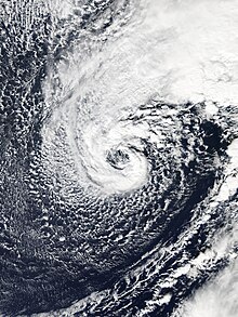
A subtropical cyclone is a weather system that has some characteristics of both tropical and extratropical cyclones.

<span class="mw-page-title-main">Low-pressure area</span> Area with air pressures lower than adjacent areas

In meteorology, a low-pressure area, low area or low is a region where the atmospheric pressure is lower than that of surrounding locations. Low-pressure areas are commonly associated with inclement weather, while high-pressure areas are associated with lighter winds and clear skies. Winds circle anti-clockwise around lows in the northern hemisphere, and clockwise in the southern hemisphere, due to opposing Coriolis forces. Low-pressure systems form under areas of wind divergence that occur in the upper levels of the atmosphere (aloft). The formation process of a low-pressure area is known as cyclogenesis. In meteorology, atmospheric divergence aloft occurs in two kinds of places:

<span class="mw-page-title-main">South Atlantic tropical cyclone</span> Tropical cyclones in the South Atlantic Ocean

South Atlantic tropical cyclones are unusual weather events that occur in the Southern Hemisphere. Strong wind shear, which disrupts the formation of cyclones, as well as a lack of weather disturbances favorable for development in the South Atlantic Ocean, make any strong tropical system extremely rare, and Hurricane Catarina in 2004 is the only recorded South Atlantic hurricane in history. Storms can develop year-round in the South Atlantic, with activity peaking during the months from November through May. Since 2011, the Brazilian Navy Hydrographic Center has assigned names to tropical and subtropical systems in the western side of the basin, near the eastern coast of Brazil, when they have sustained wind speeds of at least 65 km/h (40 mph), the generally accepted minimum sustained wind speed for a disturbance to be designated as a tropical storm in the North Atlantic basin. Below is a list of notable South Atlantic tropical and subtropical cyclones.

<span class="mw-page-title-main">1967 Atlantic hurricane season</span> Hurricane season in the Atlantic Ocean

The 1967 Atlantic hurricane season was an active Atlantic hurricane season overall, producing 13 nameable storms, of which 6 strengthened into hurricanes. The season officially began on June 1, 1967, and lasted until November 30, 1967. These dates, adopted by convention, historically describe the period in each year when most tropical cyclogenesis occurs in the Atlantic Ocean. The season's first system, Tropical Depression One, formed on June 10, and the last, Tropical Storm Heidi, lost tropical characteristics on November 2.

<span class="mw-page-title-main">Westerlies</span> Prevailing winds from the west

The westerlies, anti-trades, or prevailing westerlies, are prevailing winds from the west toward the east in the middle latitudes between 30 and 60 degrees latitude. They originate from the high-pressure areas in the horse latitudes and trend towards the poles and steer extratropical cyclones in this general manner. Tropical cyclones which cross the subtropical ridge axis into the westerlies recurve due to the increased westerly flow. The winds are predominantly from the southwest in the Northern Hemisphere and from the northwest in the Southern Hemisphere.

<span class="mw-page-title-main">1957 Atlantic hurricane season</span> Hurricane season in the Atlantic Ocean

The 1957 Atlantic hurricane season featured one of the longest-travelling tropical cyclones in the Atlantic basin, Hurricane Carrie. Nevertheless, the season was generally inactive, with eight tropical storms – two of which went unnamed – and three hurricanes, two of which intensified further to attain major hurricane intensity. The season officially began on June 15 and ended on November 15, though the year's first tropical cyclone developed prior to the start of the season on June 8. The final storm dissipated on October 27, well before the official end of the season. The strongest hurricane of the year was Carrie, which reached the equivalent of a Category 4 hurricane on the Saffir–Simpson hurricane scale on two separate occasions in the open Atlantic; Carrie later caused the sinking of the German ship Pamir southwest of the Azores, resulting in 80 deaths.

<span class="mw-page-title-main">Cyclogenesis</span> The development or strengthening of cyclonic circulation in the atmosphere

Cyclogenesis is the development or strengthening of cyclonic circulation in the atmosphere. Cyclogenesis is an umbrella term for at least three different processes, all of which result in the development of some sort of cyclone, and at any size from the microscale to the synoptic scale.

<span class="mw-page-title-main">1940 Atlantic hurricane season</span> Hurricane season in the Atlantic Ocean

The 1940 Atlantic hurricane season was a generally average period of tropical cyclogenesis in 1940. Though the season had no official bounds, most tropical cyclone activity occurred during August and September. Throughout the year, fourteen tropical cyclones formed, of which nine reached tropical storm intensity; six were hurricanes. None of the hurricanes reached major hurricane intensity. Tropical cyclones that did not approach populated areas or shipping lanes, especially if they were relatively weak and of short duration, may have remained undetected. Because technologies such as satellite monitoring were not available until the 1960s, historical data on tropical cyclones from this period are often not reliable. As a result of a reanalysis project which analyzed the season in 2012, an additional hurricane was added to HURDAT. The year's first tropical storm formed on May 19 off the northern coast of Hispaniola. At the time, this was a rare occurrence, as only four other tropical disturbances were known to have formed prior during this period; since then, reanalysis of previous seasons has concluded that there were more than four tropical cyclones in May before 1940. The season's final system was a tropical disturbance situated in the Greater Antilles, which dissipated on November 8.

<span class="mw-page-title-main">1927 Atlantic hurricane season</span> Hurricane season in the Atlantic Ocean

The 1927 Atlantic hurricane season was a relatively inactive season, with eight tropical storms, four of which became hurricanes. One of these became a major hurricane – Category 3 or higher on the modern day Saffir–Simpson scale. The first system, a tropical depression, developed on August 13, while the final cyclone, a tropical storm, merged with a cold front on November 21. No hurricane made landfall in the United States, in contrast to the four that struck the U.S. in the previous season.

<span class="mw-page-title-main">1912 Atlantic hurricane season</span> Hurricane season in the Atlantic Ocean

The 1912 Atlantic hurricane season was an average hurricane season that featured the first recorded November major hurricane. There were eleven tropical cyclones, seven of which became tropical storms; four of those strengthened into hurricanes, and one reached major hurricane intensity. The season's first cyclone developed on April 4, while the final dissipated on November 21. The season's most intense and most devastating tropical cyclone was the final storm, known as the Jamaica hurricane. It produced heavy rainfall on Jamaica, leading to at least 100 fatalities and about $1.5 million (1912 USD) in damage. The storm was also blamed for five deaths in Cuba.

<span class="mw-page-title-main">Tropical cyclogenesis</span> Development and strengthening of a tropical cyclone in the atmosphere

Tropical cyclogenesis is the development and strengthening of a tropical cyclone in the atmosphere. The mechanisms through which tropical cyclogenesis occurs are distinctly different from those through which temperate cyclogenesis occurs. Tropical cyclogenesis involves the development of a warm-core cyclone, due to significant convection in a favorable atmospheric environment.

<span class="mw-page-title-main">1996 Lake Huron cyclone</span> Subtropical storm system in 1996

The 1996 Lake Huron cyclone, commonly referred to as Hurricane Huron and Hurroncane, was an extremely rare, strong cyclonic storm system that developed over Lake Huron in September 1996. The system resembled a subtropical cyclone at its peak, bearing some characteristics of a tropical cyclone. It was the first time such a storm has ever been recorded forming over the Great Lakes region.

<span class="mw-page-title-main">Explosive cyclogenesis</span> Rapidly deepening extratropical cyclonic low-pressure area

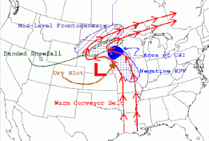
Explosive cyclogenesis is the rapid deepening of an extratropical cyclonic low-pressure area. The change in pressure needed to classify something as explosive cyclogenesis is latitude dependent. For example, at 60° latitude, explosive cyclogenesis occurs if the central pressure decreases by 24 millibars (0.71 inHg) or more in 24 hours. This is a predominantly maritime, winter event, but also occurs in continental settings. This process is the extratropical equivalent of the tropical rapid deepening. Although their cyclogenesis is entirely different from that of tropical cyclones, bomb cyclones can produce winds of 74 to 95 mph, the same order as the first categories of the Saffir–Simpson scale, and yield heavy precipitation. Even though only a minority of bomb cyclones become this strong, some weaker ones can also cause significant damage.

<span class="mw-page-title-main">1975 Pacific Northwest hurricane</span> Category 1 Pacific hurricane in 1975

The 1975 Pacific Northwest hurricane was an unusual Pacific tropical cyclone that attained hurricane status farther north than any other Pacific hurricane. It was officially unnamed, with the cargo ship Transcolorado providing vital meteorological data in assessing the storm. The twelfth tropical cyclone of the 1975 Pacific hurricane season, it developed from a cold-core upper-level low merging with the remnants of a tropical cyclone on August 31, well to the northeast of Hawaii. Convection increased as the circulation became better defined, and by early on September 2, it became a tropical storm. Turning to the northeast through an area of warm water temperatures, the storm quickly strengthened, and, after developing an eye, it attained hurricane status late on September 3, while located about 1,200 miles (1,950 km) south of Alaska. After maintaining peak winds for about 18 hours, the storm rapidly weakened, as it interacted with an approaching cold front. Early on September 5, it lost its identity near the coast of Alaska.

<span class="mw-page-title-main">2006 Central Pacific cyclone</span> Unusual cyclonic formation in the Pacific Ocean

The 2006 Central Pacific cyclone, also known as Invest 91C or Storm 91C, was an unusual weather system that formed in 2006. Forming on October 30 from a mid-latitude cyclone in the north Pacific mid-latitudes, it moved over waters warmer than normal. The system acquired some features more typical of subtropical and even tropical cyclones. However, as it neared the western coastline of North America, the system fell apart, dissipating soon after landfall, on November 4. Moisture from the storm's remnants caused substantial rainfall in British Columbia and the Pacific Northwest. The exact status and nature of this weather event is unknown, with meteorologists and weather agencies having differing opinions.

<span class="mw-page-title-main">Inflow (meteorology)</span> Meteorological term for flow of a fluid into a large collection of itself

Inflow is the flow of a fluid into a large collection of that fluid. Within meteorology, inflow normally refers to the influx of warmth and moisture from air within the Earth's atmosphere into storm systems. Extratropical cyclones are fed by inflow focused along their cold front and warm fronts. Tropical cyclones require a large inflow of warmth and moisture from warm oceans in order to develop significantly, mainly within the lowest 1 kilometre (0.62 mi) of the atmosphere. Once the flow of warm and moist air is cut off from thunderstorms and their associated tornadoes, normally by the thunderstorm's own rain-cooled outflow boundary, the storms begin to dissipate. Rear inflow jets behind squall lines act to erode the broad rain shield behind the squall line, and accelerate its forward motion.

<span class="mw-page-title-main">Cold-core low</span> Cyclone with an associated cold pool of air at high altitude

A cold-core low, also known as an upper level low or cold-core cyclone, is a cyclone aloft which has an associated cold pool of air residing at high altitude within the Earth's troposphere, without a frontal structure. It is a low pressure system that strengthens with height in accordance with the thermal wind relationship. If a weak surface circulation forms in response to such a feature at subtropical latitudes of the eastern north Pacific or north Indian oceans, it is called a subtropical cyclone. Cloud cover and rainfall mainly occurs with these systems during the day.

<span class="mw-page-title-main">Mediterranean tropical-like cyclone</span> Hurricane-like storms in the Mediterranean Sea

Mediterranean tropical-like cyclones, often referred to as Mediterranean cyclones or Mediterranean hurricanes, and informally as medicanes, are meteorological phenomena occasionally observed over the Mediterranean Sea. On a few rare occasions, some storms have been observed reaching the strength of a Category 1 hurricane, on the Saffir–Simpson scale, and Cyclone Ianos in 2020 was recorded reaching Category 2 intensity. The main societal hazard posed by medicanes is not usually from destructive winds, but through life-threatening torrential rains and flash floods.

<span class="mw-page-title-main">Hurricane Alex (2016)</span> Category 1 Atlantic hurricane in 2016

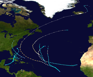
Hurricane Alex was the first Atlantic hurricane to occur in January since Hurricane Alice of 1954–55. Alex originated as a non-tropical low near the Bahamas on January 7, 2016. Initially traveling northeast, the system passed by Bermuda on January 8 before turning southeast and deepening. It briefly acquired hurricane-force winds by January 10, then weakened slightly before curving towards the east and later northeast. Acquiring more tropical weather characteristics over time, the system transitioned into a subtropical cyclone well south of the Azores on January 12, becoming the first North Atlantic tropical or subtropical cyclone in January since Tropical Storm Zeta of 2005–2006. Alex continued to develop tropical features while turning north-northeast, and transitioned into a fully tropical cyclone on January 14. The cyclone peaked in strength as a Category 1 hurricane on the Saffir–Simpson scale (SSHWS), with maximum sustained winds of 85 mph and a central pressure of 981 mbar. Alex weakened to a high-end tropical storm before making landfall on Terceira Island on January 15. By that time, the storm was losing its tropical characteristics; it fully transitioned back into a non-tropical cyclone several hours after moving away from the Azores. Alex ultimately merged with another cyclone over the Labrador Sea on January 17.

References

  1. 1 2 DeCaria (2005-12-07). "ESCI 241 – Meteorology; Lesson 16 – Extratropical Cyclones". Department of Earth Sciences, Millersville University. Archived from the original on 2008-02-08. Retrieved 2009-06-21.
  2. Robert Hart; Jenni Evans (2003). "Synoptic Composites of the Extratropical Transition Lifecycle of North Atlantic TCs as Defined Within Cyclone Phase Space" (PDF). American Meteorological Society . Retrieved 2006-10-03.
  3. Ryan N. Maue (2004-12-07). "Chapter 3: Cyclone Paradigms and Extratropical Transition Conceptualizations". Archived from the original on 2008-05-10. Retrieved 2008-06-15.
  4. 1 2 Messmer, Martina; Ian Simmonds (2021). "Global analysis of cyclone-induced compound precipitation and wind extreme events". Weather and Climate Extremes. 32: 100324. Bibcode:2021WCE....3200324M. doi: 10.1016/j.wace.2021.100324 . ISSN   2212-0947.
  5. Ian Simmonds; Kevin Keay (February 2000). "Variability of Southern Hemisphere Extratropical Cyclone Behavior, 1958–97". Journal of Climate. 13 (3): 550–561. Bibcode:2000JCli...13..550S. doi: 10.1175/1520-0442(2000)013<0550:VOSHEC>2.0.CO;2 . ISSN   1520-0442.
  6. S. K. Gulev; O. Zolina; S. Grigoriev (2001). "Winter Storms in the Northern Hemisphere (1958–1999)". Climate Dynamics. 17 (10): 795–809. Bibcode:2001ClDy...17..795G. doi:10.1007/s003820000145. S2CID   129364159.
  7. Carlyle H. Wash; Stacey H. Heikkinen; Chi-Sann Liou; Wendell A. Nuss (February 1990). "A Rapid Cyclogenesis Event during GALE IOP 9". Monthly Weather Review. 118 (2): 234–257. Bibcode:1990MWRv..118..375W. doi: 10.1175/1520-0493(1990)118<0375:ARCEDG>2.0.CO;2 . ISSN   1520-0493 . Retrieved 2008-06-28.
  8. Jack Williams (2005-05-20). "Bomb cyclones ravage northwestern Atlantic". USA Today. Retrieved 2006-10-04.
  9. Glossary of Meteorology (June 2000). "Bomb". American Meteorological Society. Retrieved 2009-06-21.
  10. Frederick Sanders; John R. Gyakum (October 1980). "Synoptic-Dynamic Climatology of the "Bomb"". Monthly Weather Review . 108 (10): 1589. Bibcode:1980MWRv..108.1589S. doi: 10.1175/1520-0493(1980)108<1589:SDCOT>2.0.CO;2 .
  11. Joseph M. Sienkiewicz; Joan M. Von Ahn; G. M. McFadden (2005-07-18). "Hurricane Force Extratropical Cyclones" (PDF). American Meteorology Society. Retrieved 2006-10-21.
  12. "Great weather events — A record-breaking Atlantic weather system". U.K. Met Office. Archived from the original on 2008-07-07. Retrieved 2009-05-26.
  13. Brümmer B.; Thiemann S.; Kirchgässner A. (2000). "A cyclone statistics for the Arctic based on European Centre re-analysis data (Abstract)". Meteorology and Atmospheric Physics. 75 (3–4): 233–250. Bibcode:2000MAP....75..233B. doi:10.1007/s007030070006. ISSN   0177-7971. S2CID   119849630 . Retrieved 2006-10-04.
  14. 1 2 Robert E. Hart; Jenni L. Evans (February 2001). "A climatology of extratropical transition of tropical cyclones in the North Atlantic". Journal of Climate. 14 (4): 546–564. Bibcode:2001JCli...14..546H. doi: 10.1175/1520-0442(2001)014<0546:ACOTET>2.0.CO;2 .
  15. "Glossary of Hurricane Terms". Canadian Hurricane Center. 2003-07-10. Archived from the original on 2006-10-02. Retrieved 2006-10-04.
  16. National Hurricane Center (2011-07-11). "Glossary of NHC Terms: P". National Oceanic and Atmospheric Administration . Retrieved 2011-07-23.
  17. 1 2 Jenni L. Evans; Robert E. Hart (May 2003). "Objective indicators of the life cycle evolution of extratropical transition for Atlantic tropical cyclones". Monthly Weather Review. 131 (5): 909–925. Bibcode:2003MWRv..131..909E. doi:10.1175/1520-0493(2003)131<0909:OIOTLC>2.0.CO;2. S2CID   3744671.
  18. Robert E. Hart (April 2003). "A Cyclone Phase Space Derived from Thermal Wind and Thermal Asymmetry". Monthly Weather Review. 131 (4): 585–616. Bibcode:2003MWRv..131..585H. doi: 10.1175/1520-0493(2003)131<0585:ACPSDF>2.0.CO;2 . S2CID   3753455.
  19. 1 2 Robert E. Hart; Clark Evans; Jenni L. Evans (February 2006). "Synoptic composites of the extratropical transition lifecycle of North Atlantic tropical cyclones: Factors determining post-transition evolution". Monthly Weather Review. 134 (2): 553–578. Bibcode:2006MWRv..134..553H. CiteSeerX   10.1.1.488.5251 . doi:10.1175/MWR3082.1. S2CID   3742254.
  20. Mark P. Guishard; Jenni L. Evans; Robert E. Hart (July 2009). "Atlantic Subtropical Storms. Part II: Climatology". Journal of Climate. 22 (13): 3574–3594. Bibcode:2009JCli...22.3574G. doi: 10.1175/2008JCLI2346.1 . S2CID   51435473.
  21. Jenni L. Evans; Mark P. Guishard (July 2009). "Atlantic Subtropical Storms. Part I: Diagnostic Criteria and Composite Analysis". Monthly Weather Review. 137 (7): 2065–2080. Bibcode:2009MWRv..137.2065E. doi: 10.1175/2009MWR2468.1 .
  22. David M. Roth (2002-02-15). "A Fifty year History of Subtropical Cyclones" (PDF). Hydrometeorological Prediction Center. Retrieved 2006-10-04.
  23. Michelle L. Stewart; M. A. Bourassa (2006-04-25). "Cyclogenesis and Tropical Transition in decaying frontal zones" . Retrieved 2006-10-24.
  24. Christopher A. Davis; Lance F. Bosart (November 2004). "The TT Problem — Forecasting the Tropical Transition of Cyclones". Bulletin of the American Meteorological Society . 85 (11): 1657–1662. Bibcode:2004BAMS...85.1657D. doi: 10.1175/BAMS-85-11-1657 . S2CID   122903747.
  25. Velden, C.; et al. (Aug 2006). "The Dvorak Tropical Cyclone Intensity Estimation Technique: A Satellite-Based Method that Has Endured for over 30 Years" (PDF). Bulletin of the American Meteorological Society . 87 (9): 1195–1210. Bibcode:2006BAMS...87.1195V. CiteSeerX   10.1.1.669.3855 . doi:10.1175/BAMS-87-9-1195. S2CID   15193271 . Retrieved 2008-11-07.
  26. Lander, Mark A. (2004). "Monsoon depressions, monsoon gyres, midget tropical cyclones, TUTT cells, and high intensity after recurvature: Lessons learned from the use of Dvorak's techniques in the world's most prolific tropical-cyclone basin" (PDF). 26th Conference on Hurricanes and Tropical Meteorology. Retrieved 2008-11-08.
  27. "JTWC TN 97/002 Page 1". Archived from the original on 2012-02-08.
  28. 1 2 "JTWC TN 97/002 Page 8". Archived from the original on 2012-02-08.
  29. 1 2 "JTWC TN 97/002 Page 2". Archived from the original on 2012-02-08.
  30. "WW2010 - Pressure Gradient Force". University of Illinois. 1999-09-02. Retrieved 2006-10-11.
  31. "The Atmosphere in Motion" (PDF). University of Aberdeen. Archived from the original (PDF) on 2013-09-07. Retrieved 2011-09-11.
  32. "The Atmosphere in motion: Pressure & mass" (PDF). Ohio State University. 2006-04-26. Archived from the original (PDF) on 2006-09-05. Retrieved 2009-06-21.
  33. "What is a TROWAL?". St. Louis University. 2003-08-04. Archived from the original on 2006-09-16. Retrieved 2006-11-02.
  34. Andrea Lang (2006-04-20). "Mid-Latitude Cyclones: Vertical Structure". University of Wisconsin-Madison Department of Atmospheric and Oceanic Sciences. Archived from the original on 2006-09-03. Retrieved 2006-10-03.
  35. Robert Hart (2003-02-18). "Cyclone Phase Analysis and Forecast: Help Page". Florida State University Department of Meteorology. Retrieved 2006-10-03.
  36. Robert Harthi (2006-10-04). "Cyclone phase evolution: Analyses & Forecasts". Florida State University Department of Meteorology. Retrieved 2006-10-03.
  37. David M. Roth (2005-12-15). "Unified Surface Analysis Manual" (PDF). Hydrometeorological Prediction Center (NOAA). Retrieved 2006-10-11.
  38. Shaye Johnson (2001-09-25). "The Norwegian Cyclone Model" (PDF). University of Oklahoma, School of Meteorology. Archived from the original (PDF) on 2006-09-01. Retrieved 2006-10-11.
  39. 1 2 David M. Schultz; Heini Werli (2001-01-05). "Determining Midlatitude Cyclone Structure and Evolution from the Upper-Level Flow". Cooperative Institute for Mesoscale Meteorological Studies. Retrieved 2006-10-09.
  40. 1 2 Ryan N. Maue (2006-04-25). "Warm seclusion cyclone climatology". American Meteorological Society Conference. Retrieved 2006-10-06.
  41. Jeff Masters (2006-02-14). "Blizzicanes". JeffMasters' Blog on Wunderground.Com. Retrieved 2006-11-01.
  42. Richard J. Pasch; Eric S. Blake (February 8, 2006). Tropical Cyclone Report: Hurricane Maria (PDF) (Report). Miami Florida: National Hurricane Center. Retrieved July 21, 2021.
  43. Fontaine, Andie Sophia (September 1, 2014). "Stormy Weather Is Hurricane Cristobal Petering Out". The Reykjavík Grapevine . Retrieved July 21, 2021.
  44. Glossary of Meteorology (June 2000). "Zonal Flow". American Meteorological Society. Archived from the original on 2007-03-13. Retrieved 2006-10-03.
  45. Glossary of Meteorology (June 2000). "Meridional Flow". American Meteorological Society. Archived from the original on 2006-10-26. Retrieved 2006-10-03.
  46. Anthony R. Lupo; Phillip J. Smith (February 1998). "The Interactions between a Midlatitude Blocking Anticyclone and Synoptic-Scale Cyclones That Occurred during the Summer Season". Monthly Weather Review. 126 (2): 502–515. Bibcode:1998MWRv..126..502L. doi:10.1175/1520-0493(1998)126<0502:TIBAMB>2.0.CO;2. hdl: 10355/2398 . ISSN   1520-0493.
  47. B. Ziv; P. Alpert (December 2003). "Theoretical and Applied Climatology — Rotation of mid-latitude binary cyclones: a potential vorticity approach". Theoretical and Applied Climatology. 76 (3–4): 189–202. Bibcode:2003ThApC..76..189Z. doi:10.1007/s00704-003-0011-x. ISSN   0177-798X. S2CID   54982309.
  48. Joan Von Ahn; Joe Sienkiewicz; Greggory McFadden (April 2005). "Mariners Weather Log, Vol 49, No. 1". Voluntary Observing Ship Program. Retrieved 2006-10-04.
  49. "WW2010 - Squall Lines". University of Illinois. 1999-09-02. Retrieved 2006-10-21.
  50. "Tornadoes: Nature's Most Violent Storms". National Severe Storms Laboratory (NOAA). 2002-03-13. Archived from the original on 2006-10-26. Retrieved 2006-10-21.
  51. "The Great Storm of 1987". Met Office. Archived from the original on 2007-04-02. Retrieved 2006-10-30.
  52. Richard J. Pasch; Eric S. Blake; Hugh D. Cobb III & David P Roberts (2006-01-12). "Tropical Cyclone Report — Hurricane Wilma" (PDF). National Hurricane Center (NOAA). Retrieved 2006-10-11.
  53. "华北东北黄淮强降雨致289人死亡失踪" (in Chinese). Ministry of Civil Affairs. July 25, 2016. Archived from the original on July 25, 2016. Retrieved July 25, 2016.
  54. "西南部分地区洪涝灾害致80余万人受灾" (in Chinese). Ministry of Civil Affairs. July 25, 2016. Archived from the original on July 25, 2016. Retrieved July 25, 2016.
  55. Holton, James R. 1992 An introduction to dynamic meteorology / James R. Holton Academic Press, San Diego : https://www.loc.gov/catdir/toc/els032/91040568.html
  56. Linear Stationary Wave Simulations of the Time-Mean Climatological Flow, Paul J. Valdes, Brian J. Hoskins, Journal of the Atmospheric Sciences 1989 46:16, 2509–2527
  57. Hewson, Tim; Day, Jonathan; Hersbach, Hans (January 2023). "The deepest extratropical cyclone of modern times?". Newsletter. European Centre for Medium-Range Weather Forecasts. Retrieved 8 November 2023.
  58. 1 2 Lin, Peiyi; Zhong, Rui; Yang, Qinghua; Clem, Kyle R.; Chen, Dake (28 July 2023). "A Record‐Breaking Cyclone Over the Southern Ocean in 2022". Geophysical Research Letters. 50 (14). Bibcode:2023GeoRL..5004012L. doi: 10.1029/2023GL104012 .
  59. Odell, Luke; Knippertz, Peter; Pickering, Steven; Parkes, Ben; Roberts, Alexander (April 2013). "The Braer storm revisited" (PDF). Weather. 68 (4): 105–111. Bibcode:2013Wthr...68..105O. doi:10.1002/wea.2097. S2CID   120025537 . Retrieved 8 November 2023.
  60. Burt, S. D. (February 1987). "A New North Atlantic Low Pressure Record" (PDF). Weather. 42 (2): 53–56. Bibcode:1987Wthr...42...53B. doi:10.1002/j.1477-8696.1987.tb06919.x . Retrieved 16 August 2015.
  61. "Marine Weather Warning for GMDSS Metarea XI 2014-11-08T06:00:00Z". Japan Meteorological Agency. 8 November 2014. Archived from the original on 8 November 2014. Retrieved 12 November 2023.
  62. Wiltgen, Nick; Erdman, Jonatha (9 November 2014). "Bering Sea Superstorm Among the Strongest Extratropical Cyclones on Record". The Weather Channel. Retrieved 12 November 2023.
  63. Zaffino, Matt (27 October 2021). "Bomb cyclone: What it is, where the term came from and why it's not a hurricane". KGW. Retrieved 12 November 2023.
  64. Kong (4 January 2018). "STORM SUMMARY NUMBER 5 FOR EASTERN U.S. WINTER STORM". Wea. Archived from the original on 5 January 2018. Retrieved 19 November 2023.
  65. "Freak storm dissipates over England". HISTORY. Retrieved 6 December 2023.
  66. "The flood of 1953 - Rescue and consequences". Deltawerken. Archived from the original on 6 May 2019. Retrieved 6 December 2023.
  67. "System Explanation of Floods in Central Europe". Natural Disaster Networking Platform. Archived from the original on 4 March 2008. Retrieved 6 December 2023.
  68. Kundzewicz, Zbigniew W.; Pińskwar, Iwona; Brakenridge, G. Robert (January 2013). "Large floods in Europe, 1985–2009" (PDF). Hydrological Sciences Journal. Hydrological Sciences Journal. pp. 1–7. doi:10.1080/02626667.2012.745082 . Retrieved 6 December 2023.
  69. Tatge, Yörn (9 December 2009). "Looking Back, Looking Forward: Anatol, Lothar and Martin Ten Years Later". Verisk. Retrieved 6 December 2023.
  70. "Christmas 20 years ago: Storms Lothar and Martin wreak havoc across Europe". Swiss Re. Retrieved 6 December 2023.
  71. Blake, Eric S; Kimberlain, Todd B; Berg, Robert J; Cangialosi, John P; Beven II, John L (12 February 2013). Hurricane Sandy: October 22 – 29, 2012 (PDF) (Report). National Hurricane Center. Retrieved 21 December 2023.
  72. Costliest U.S. tropical cyclones tables updated (PDF) (Report). National Hurricane Center. 26 January 2018. Retrieved 21 December 2023.
  73. "Storm Events Database". National Centers for Environmental Information. Retrieved 5 January 2024.
  74. Mike Soltow (25 April 2011). "Storm Summary Number 11 For Central U.S. Heavy Rain Event". Weather Prediction Center . Retrieved 5 January 2024.
  75. Corfidi, Stephen F.; Levit, Jason J.; Weiss, Steven J. "The Super Outbreak: Outbreak of the Century" (PDF). Storm Prediction Center. Retrieved 5 January 2024.
  76. "April 11th 1965 Palm Sunday Tornado Outbreak". National Weather Service. Retrieved 5 January 2024.
  77. "On Mar 12 in weather history..." National Weather Service. Archived from the original on 1 February 2014. Retrieved 20 January 2024.
  78. "NOAA's Top U.S. Weather, Water and Climate Events of the 20th Century". National Ocean and Atmospheric Administration. Archived from the original on 15 August 2000. Retrieved 20 January 2024.
  79. "Superstorm of 1993 "Storm of the Century"". National Weather Service. Retrieved 20 January 2024.
  80. "East Thaws Out From Freeze; 286 Left Dead". Newspapers.com. Pasadena Independent. 15 December 1960. Retrieved 23 January 2024.
  81. "Billion-Dollar Weather and Climate Disasters". National Centers for Environmental Information. Retrieved 23 January 2024.
  82. "洞爺丸台風 昭和29年(1954年) 9月24日~9月27日". www.data.jma.go.jp (in Japanese). Retrieved 23 January 2024.
  83. 第2版,日本大百科全書(ニッポニカ) , 百科事典マイペディア,デジタル大辞泉プラス,世界大百科事典 . "洞爺丸台風(とうやまるたいふう)とは". コトバンク (in Japanese). Retrieved 23 January 2024.
  84. "华北东北黄淮强降雨致289人死亡失踪" (in Chinese). Ministry of Civil Affairs. 23 July 2016. Archived from the original on 25 July 2016. Retrieved 23 January 2024.
  85. "西南部分地区洪涝灾害致80余万人受灾" (in Chinese). Ministry of Civil Affairs. 25 July 2016. Archived from the original on 25 July 2016. Retrieved 23 January 2024.