Anticyclone

Last updated
An anticyclone just below Southern Australia near Tasmania. High Pressure.jpg
An anticyclone just below Southern Australia near Tasmania.
Hadley cell circulation tends to create anticyclonic patterns in the Horse latitudes, depositing drier air and contributing to the world's great deserts. HadleyCross-sec.jpg
Hadley cell circulation tends to create anticyclonic patterns in the Horse latitudes, depositing drier air and contributing to the world's great deserts.

An anticyclone is a weather phenomenon defined as a large-scale circulation of winds around a central region of high atmospheric pressure, clockwise in the Northern Hemisphere and counterclockwise in the Southern Hemisphere as viewed from above (opposite to a cyclone). [1] Effects of surface-based anticyclones include clearing skies as well as cooler, drier air. Fog can also form overnight within a region of higher pressure.

Contents

Mid-tropospheric systems, such as the subtropical ridge, deflect tropical cyclones around their periphery and cause a temperature inversion inhibiting free convection near their center, building up surface-based haze under their base. Anticyclones aloft can form within warm-core lows such as tropical cyclones, due to descending cool air from the backside of upper troughs such as polar highs, or from large-scale sinking such as a subtropical ridge. The evolution of an anticyclone depends upon variables such as its size, intensity, and extent of moist convection, as well as the Coriolis force. [2]

History

Sir Francis Galton first discovered anticyclones in the 1860s. High-pressure systems are alternatively referred to as anticyclones. Their circulation is sometimes referred to as cum sole. Subtropical high-pressure zones form under the descending portion of the Hadley cell circulation. Upper-level high-pressure areas lie over tropical cyclones due to their warm core nature.

Surface anticyclones form due to downward motion through the troposphere, the atmospheric layer where weather occurs. Preferred areas within a synoptic flow pattern in higher levels of the troposphere are beneath the western side of troughs. On weather maps, these areas show converging winds (isotachs), also known as confluence, or converging height lines near or above the level of non-divergence, which is near the 500 hPa pressure surface about midway up the troposphere. [3] [4] Because they weaken with height, these high-pressure systems are cold.

Subtropical ridge

The subtropical ridge shows up as a large area of black (dryness) on this water vapor satellite image from September 2000. Subtropicalridge2000091412.jpg
The subtropical ridge shows up as a large area of black (dryness) on this water vapor satellite image from September 2000.

Heating of the earth near the equator forces upward motion and convection along the monsoon trough or intertropical convergence zone. The divergence over the near-equatorial trough leads to air rising and moving away from the equator and to the poles aloft. As air moves towards the mid-latitudes, it cools and sinks leading to subsidence near the 30° parallel of both hemispheres. This circulation known as the Hadley cell forms the subtropical ridge. [5] Many of the world's deserts are caused by these climatological high-pressure areas. [6] Because these anticyclones strengthen with height, they are known as warm core ridges.

Formation aloft

The development of anticyclones aloft occurs in warm core cyclones such as tropical cyclones when latent heat caused by the formation of clouds is released aloft increasing the air temperature; the resultant thickness of the atmospheric layer increases high pressure aloft which evacuates their outflow.

Structure

In the absence of rotation, the wind tends to blow from areas of high pressure to areas of low pressure. [7] The stronger the pressure difference (pressure gradient) between a high-pressure system and a low-pressure system, the stronger the wind. The coriolis force caused by Earth's rotation gives winds within high-pressure systems their clockwise circulation in the northern hemisphere (as the wind moves outward and is deflected right from the center of high pressure) and anticlockwise circulation in the southern hemisphere (as the wind moves outward and is deflected left from the center of high pressure). Friction with land slows down the wind flowing out of high-pressure systems and causes wind to flow more outward (more ageostrophically) from the center. [8]

Effects

Surface-based systems

Golden Gate Bridge in fog GGB in fog 2007 edit.jpg
Golden Gate Bridge in fog

High-pressure systems are frequently associated with light winds at the surface and subsidence of air from higher portions of the troposphere. Subsidence will generally warm an air mass by adiabatic (compressional) heating. [9] Thus, high pressure typically brings clear skies. [10] Because no clouds are present to reflect sunlight during the day, there is more incoming solar radiation and heating so temperatures rise rapidly near the surface. At night, the absence of clouds means that outgoing longwave radiation (i.e. heat energy from the surface) is not blocked, allowing the escape of heat and giving cooler diurnal low temperatures in all seasons. When surface winds become light, the subsidence produced directly under a high-pressure system can lead to a buildup of particulates in urban areas under the high pressure, leading to widespread haze. [11] If the surface level relative humidity rises towards 100 percent overnight, fog can form. [12]

The movement of continental arctic air masses to lower latitudes produces strong but vertically shallow high-pressure systems.these systems affect their pressure. [13] The surface level, sharp temperature inversion can lead to areas of persistent stratocumulus or stratus cloud, colloquially known as anticyclonic gloom. The type of weather brought about by an anticyclone depends on its origin. For example, extensions of the Azores high pressure may bring about anticyclonic gloom during the winter because they pick up moisture as they move over the warmer oceans. High pressures that build to the north and move southwards often bring clear weather because they are cooled at the base (as opposed to warmed) which helps prevent clouds from forming.

Once arctic air moves over an unfrozen ocean, the air mass modifies greatly over the warmer water and takes on the character of a maritime air mass, which reduces the strength of the high-pressure system. [14] When extremely cold air moves over relatively warm oceans, polar lows can develop. [15] However, warm and moist (or maritime tropical) air masses which move poleward from tropical sources are slower to modify than arctic air masses. [16]

Mid-tropospheric systems

Mean July subtropical ridge position in North America Subtropridgejulyna.gif
Mean July subtropical ridge position in North America

The circulation around mid-level (altitude) ridges, and the air subsidence at their center, act to steer tropical cyclones around and out their periphery. Due to the subsidence within this type of system, a cap can develop which inhibits free convection and hence mixing of the lower with the middle level troposphere. This limits thunderstorms and other low-pressure weather activity near their centers and traps low-level pollutants such as ozone as haze under their base, which is a significant problem in large urban centers during summer months such as Los Angeles, California and Mexico City.

Upper tropospheric systems

The existence of upper-level (altitude) high pressure allows upper level divergence which leads to surface convergence. If a capping mid-level ridge does not exist, this leads to free convection and the development of showers and thunderstorms if the lower atmosphere is humid. Because a positive feedback loop develops between the convective tropical cyclone and the upper level high, the two system are strengthened. This loop stops once ocean temperatures cool to below 26.5 °C (79.7 °F), [17] reducing the thunderstorm activity, which then weakens the upper-level high-pressure system.

Importance to global monsoon regimes

When the subtropical ridge in the Northwest Pacific is stronger than in other areas, it leads to a wet monsoon season for Asia. [18] The subtropical ridge position is linked to how far northward monsoon moisture and thunderstorms extend into the United States. Typically, the subtropical ridge across North America migrates far enough northward to begin monsoon conditions across the Desert Southwest from July to September. [19] When the subtropical ridge is farther north than normal towards the Four Corners, thunderstorms of the New Mexican Monsoon can spread northward into Arizona and New Mexico. When suppressed to the south, the atmosphere dries out across the Desert Southwest, causing a break in the monsoon regime. [20]

Depiction on weather maps

A surface weather analysis for the United States on October 21, 2006 Surface analysis.gif
A surface weather analysis for the United States on October 21, 2006

On weather maps, high-pressure centers are associated with the letter H in English, [21] within the isobar with the highest pressure value. On constant-pressure upper-level charts, anticyclones are located within the highest height line contour. [22]

Extraterrestrial versions

On Jupiter, there are two examples of an extraterrestrial anticyclonic storm; the Great Red Spot and the recently formed Oval BA on Jupiter. They are powered by smaller storms merging [23] unlike any typical anticyclonic storm that happens on Earth where water powers them. Another theory is that warmer gases rise in a column of cold air, creating a vortex as is the case of other storms that include Anne's Spot on Saturn and the Great Dark Spot on Neptune. Anticyclones had also been detected near the poles of Venus. [24] [25]

See also

Related Research Articles

<span class="mw-page-title-main">Cyclone</span> Large scale air mass that rotates around a strong center of low pressure

In meteorology, a cyclone is a large air mass that rotates around a strong center of low atmospheric pressure, counterclockwise in the Northern Hemisphere and clockwise in the Southern Hemisphere as viewed from above. Cyclones are characterized by inward-spiraling winds that rotate about a zone of low pressure. The largest low-pressure systems are polar vortices and extratropical cyclones of the largest scale. Warm-core cyclones such as tropical cyclones and subtropical cyclones also lie within the synoptic scale. Mesocyclones, tornadoes, and dust devils lie within the smaller mesoscale. Upper level cyclones can exist without the presence of a surface low, and can pinch off from the base of the tropical upper tropospheric trough during the summer months in the Northern Hemisphere. Cyclones have also been seen on extraterrestrial planets, such as Mars, Jupiter, and Neptune. Cyclogenesis is the process of cyclone formation and intensification. Extratropical cyclones begin as waves in large regions of enhanced mid-latitude temperature contrasts called baroclinic zones. These zones contract and form weather fronts as the cyclonic circulation closes and intensifies. Later in their life cycle, extratropical cyclones occlude as cold air masses undercut the warmer air and become cold core systems. A cyclone's track is guided over the course of its 2 to 6 day life cycle by the steering flow of the subtropical jet stream.

<span class="mw-page-title-main">Horse latitudes</span> Latitudes 30–35 degrees north and south of the Equator

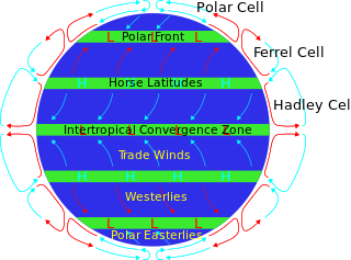
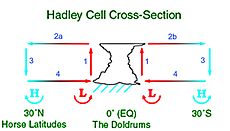
The horse latitudes are the latitudes about 30 degrees north and south of the Equator. They are characterized by sunny skies, calm winds, and very little precipitation. They are also known as subtropical ridges or highs. It is a high-pressure area at the divergence of trade winds and the westerlies.

<span class="mw-page-title-main">Subtropical cyclone</span> Cyclonic storm with both tropical and extratropical characteristics

A subtropical cyclone is a weather system that has some characteristics of both tropical and extratropical cyclones.

<span class="mw-page-title-main">High-pressure area</span> Region with higher atmospheric pressure

A high-pressure area, high, or anticyclone, is an area near the surface of a planet where the atmospheric pressure is greater than the pressure in the surrounding regions. Highs are middle-scale meteorological features that result from interplays between the relatively larger-scale dynamics of an entire planet's atmospheric circulation.

<span class="mw-page-title-main">Low-pressure area</span> Area with air pressures lower than adjacent areas

In meteorology, a low-pressure area, low area or low is a region where the atmospheric pressure is lower than that of surrounding locations. Low-pressure areas are commonly associated with inclement weather, while high-pressure areas are associated with lighter winds and clear skies. Winds circle anti-clockwise around lows in the northern hemisphere, and clockwise in the southern hemisphere, due to opposing Coriolis forces. Low-pressure systems form under areas of wind divergence that occur in the upper levels of the atmosphere (aloft). The formation process of a low-pressure area is known as cyclogenesis. In meteorology, atmospheric divergence aloft occurs in two kinds of places:

<span class="mw-page-title-main">Synoptic scale meteorology</span> 1000-km-order method of measuring weather systems

In meteorology, the synoptic scale is a horizontal length scale of the order of 1,000 km (620 mi) or more. This corresponds to a horizontal scale typical of mid-latitude depressions. Most high- and low-pressure areas seen on weather maps are synoptic-scale systems, driven by the location of Rossby waves in their respective hemisphere. Low-pressure areas and their related frontal zones occur on the leading edge of a trough within the Rossby wave pattern, while high-pressure areas form on the back edge of the trough. Most precipitation areas occur near frontal zones. The word synoptic is derived from the Ancient Greek word συνοπτικός (sunoptikós), meaning "seen together".

<span class="mw-page-title-main">Tropical wave</span> Type of atmospheric trough

A tropical wave, in and around the Atlantic Ocean, is a type of atmospheric trough, an elongated area of relatively low air pressure, oriented north to south, which moves from east to west across the tropics, causing areas of cloudiness and thunderstorms. Tropical waves form in the easterly flow along the equatorial side of the subtropical ridge or belt of high air pressure which lies north and south of the Intertropical Convergence Zone (ITCZ). Tropical waves are generally carried westward by the prevailing easterly winds along the tropics and subtropics near the equator. They can lead to the formation of tropical cyclones in the north Atlantic and northeastern Pacific basins. A tropical wave study is aided by Hovmöller diagrams, a graph of meteorological data.

<span class="mw-page-title-main">Cyclogenesis</span> The development or strengthening of cyclonic circulation in the atmosphere

Cyclogenesis is the development or strengthening of cyclonic circulation in the atmosphere. Cyclogenesis is an umbrella term for at least three different processes, all of which result in the development of some sort of cyclone, and at any size from the microscale to the synoptic scale.

<span class="mw-page-title-main">Pressure system</span> Relative peak or lull in the sea level pressure distribution

A pressure system is a peak or lull in the sea level pressure distribution. The surface pressure at sea level varies minimally, with the lowest value measured 87 kilopascals (26 inHg) and the highest recorded 108.57 kilopascals (32.06 inHg). High- and low-pressure systems evolve due to interactions of temperature differentials in the atmosphere, temperature differences between the atmosphere and water within oceans and lakes, the influence of upper-level disturbances, as well as the amount of solar heating or radiationized cooling an area receives. Pressure systems cause weather to be experienced locally. Low-pressure systems are associated with clouds and precipitation that minimize temperature changes throughout the day, whereas high-pressure systems normally associate with dry weather and mostly clear skies with larger diurnal temperature changes due to greater radiation at night and greater sunshine during the day. Pressure systems are analyzed by those in the field of meteorology within surface weather maps.

<span class="mw-page-title-main">Mesoscale convective system</span> Complex of thunderstorms organized on a larger scale

A mesoscale convective system (MCS) is a complex of thunderstorms that becomes organized on a scale larger than the individual thunderstorms but smaller than extratropical cyclones, and normally persists for several hours or more. A mesoscale convective system's overall cloud and precipitation pattern may be round or linear in shape, and include weather systems such as tropical cyclones, squall lines, lake-effect snow events, polar lows, and mesoscale convective complexes (MCCs), and generally forms near weather fronts. The type that forms during the warm season over land has been noted across North and South America, Europe, and Asia, with a maximum in activity noted during the late afternoon and evening hours.

<span class="mw-page-title-main">Mesoscale convective complex</span>

A mesoscale convective complex (MCC) is a unique kind of mesoscale convective system which is defined by characteristics observed in infrared satellite imagery. They are long-lived, often form nocturnally, and commonly contain heavy rainfall, wind, hail, lightning, and possibly tornadoes.

<span class="mw-page-title-main">Ridge (meteorology)</span> Elongated region of high atmospheric pressure

In meteorology a ridge or barometric ridge is an elongated area of relatively high atmospheric pressure compared to the surrounding environment, without being a closed circulation. It is associated with an area of maximum anticyclonic curvature of wind flow. The ridge originates in the center of an anticyclone and sandwiched between two low-pressure areas, and the locus of the maximum curvature is called the ridge line. This phenomenon is the opposite of a trough.

<span class="mw-page-title-main">1984 Pacific typhoon season</span> Typhoon season in the Pacific Ocean

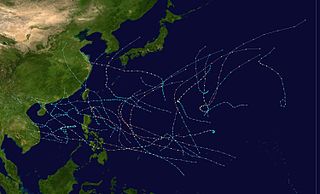
The 1984 Pacific typhoon season had the second-latest start in the basin on record, only behind the previous year by one day. It has no official bounds, but most tropical cyclones tend to form in the northwestern Pacific Ocean between May and November. These dates conventionally delimit the period of each year when most tropical cyclones form in the northwestern Pacific Ocean. Tropical Storms formed in the entire west pacific basin were assigned a name by the Joint Typhoon Warning Center. Tropical depressions that enter or form in the Philippine area of responsibility are assigned a name by the Philippine Atmospheric, Geophysical and Astronomical Services Administration or PAGASA. This can often result in the same storm having two names.

Anticyclogenesis is the development or strengthening of an anticyclonic circulation in the atmosphere. It is the opposite of anticyclolysis and has a cyclonic equivalent known as cyclogenesis. Anticyclones are alternatively referred to as high pressure systems.

<span class="mw-page-title-main">Extratropical cyclone</span> Type of cyclone

Extratropical cyclones, sometimes called mid-latitude cyclones or wave cyclones, are low-pressure areas which, along with the anticyclones of high-pressure areas, drive the weather over much of the Earth. Extratropical cyclones are capable of producing anything from cloudiness and mild showers to severe gales, thunderstorms, blizzards, and tornadoes. These types of cyclones are defined as large scale (synoptic) low pressure weather systems that occur in the middle latitudes of the Earth. In contrast with tropical cyclones, extratropical cyclones produce rapid changes in temperature and dew point along broad lines, called weather fronts, about the center of the cyclone.

<span class="mw-page-title-main">Outflow (meteorology)</span> Air that flows outwards from a storm system

Outflow, in meteorology, is air that flows outwards from a storm system. It is associated with ridging, or anticyclonic flow. In the low levels of the troposphere, outflow radiates from thunderstorms in the form of a wedge of rain-cooled air, which is visible as a thin rope-like cloud on weather satellite imagery or a fine line on weather radar imagery. For observers on the ground, a thunderstorm outflow boundary often approaches in otherwise clear skies as a low, thick cloud that brings with it a gust front.

<span class="mw-page-title-main">2001–02 South Pacific cyclone season</span> Tropical cyclone season

The 2001–02 South Pacific cyclone season was a below-average year in which only five named storms formed or entered the South Pacific basin. It began on November 1, 2001, and ended on April 30, 2002. These dates conventionally delimit the period of each year when most tropical cyclones form in the southern Pacific Ocean east of 160°E. Additionally, the regional tropical cyclone operational plan defines a tropical cyclone year separately from a tropical cyclone season, and the "tropical cyclone year" runs from July 1, 2001, to June 30, 2002. The season's sixteen tropical depressions existed within these dates with the first developing on November 29 and the last dissipating on April 22.

<span class="mw-page-title-main">Upper tropospheric cyclonic vortex</span>

An upper tropospheric cyclonic vortex is a vortex, or a circulation with a definable center, that usually moves slowly from east-northeast to west-southwest and is prevalent across Northern Hemisphere's warm season. Its circulations generally do not extend below 6,080 metres (19,950 ft) in altitude, as it is an example of a cold-core low. A weak inverted wave in the easterlies is generally found beneath it, and it may also be associated with broad areas of high-level clouds. Downward development results in an increase of cumulus clouds and the appearance of circulation at ground level. In rare cases, a warm-core cyclone can develop in its associated convective activity, resulting in a tropical cyclone and a weakening and southwest movement of the nearby upper tropospheric cyclonic vortex. Symbiotic relationships can exist between tropical cyclones and the upper level lows in their wake, with the two systems occasionally leading to their mutual strengthening. When they move over land during the warm season, an increase in monsoon rains occurs.

<span class="mw-page-title-main">Cold-core low</span> Cyclone with an associated cold pool of air at high altitude

A cold-core low, also known as an upper level low or cold-core cyclone, is a cyclone aloft which has an associated cold pool of air residing at high altitude within the Earth's troposphere, without a frontal structure. It is a low pressure system that strengthens with height in accordance with the thermal wind relationship. If a weak surface circulation forms in response to such a feature at subtropical latitudes of the eastern north Pacific or north Indian oceans, it is called a subtropical cyclone. Cloud cover and rainfall mainly occurs with these systems during the day.

<span class="mw-page-title-main">Glossary of tropical cyclone terms</span>

The following is a glossary of tropical cyclone terms.

References

  1. "Glossary: Anticyclone". National Weather Service. Archived from the original on June 29, 2011. Retrieved January 19, 2010.
  2. Rostami, Masoud; Zeitlin, Vladimir (2017). "Influence of condensation and latent heat release upon barotropic and baroclinic instabilities of vortices in a rotating shallow water f-plane model" (PDF). Geophysical & Astrophysical Fluid Dynamics. 111 (1): 1–31. Bibcode:2017GApFD.111....1R. doi:10.1080/03091929.2016.1269897. S2CID   55112620.
  3. Glossary of Meteorology (2009). Level of nondivergence. Archived 2011-06-28 at Wikiwix American Meteorological Society. Retrieved on 2009-02-17.
  4. Konstantin Matchev (2009). Middle-Latitude Cyclones - II Archived 2009-02-25 at the Wayback Machine . University of Florida. Retrieved on 2009-02-16.
  5. Dr. Owen E. Thompson (1996). Hadley Circulation Cell. Archived 2009-03-05 at the Wayback Machine Channel Video Productions. Retrieved on 2007-02-11.
  6. ThinkQuest team 26634 (1999). The Formation of Deserts Archived 2012-10-17 at the Wayback Machine . Oracle ThinkQuest Education Foundation. Retrieved on 2009-02-16.
  7. BWEA (2007). Education and Careers: What is wind? Archived 2011-03-04 at the Wayback Machine British Wind Energy Association. Retrieved on 2009-02-16.
  8. JetStream (2008). Origin of Wind Archived 2011-08-09 at the Wayback Machine . National Weather Service Southern Region Headquarters. Retrieved on 2009-02-16.
  9. Office of the Federal Coordinator for Meteorology (2006). Appendix G: Glossary Archived 2009-02-25 at the Wayback Machine . NOAA. Retrieved on 2009-02-16.
  10. Jack Williams (2007). What's that happening inside highs and lows Archived 2012-08-24 at the Wayback Machine . USA Today. Retrieved on 2009-02-16.
  11. Myanmar government (2007). Haze Archived 2007-01-27 at the Wayback Machine . Retrieved on 2007-02-11.
  12. Robert Tardif (2002). Fog characteristics Archived 2011-05-20 at the Wayback Machine . NCAR National Research Laboratory. Retrieved on 2007-02-11.
  13. CBC News (2009). Blame Yukon: Arctic air mass chills rest of North America. Canadian Broadcasting Centre. Retrieved on 2009-02-16.
  14. Federal Aviation Administration (1999). North Atlantic International General Aviation Operations Manual, Chapter 2: Environment. FAA. Retrieved on 2009-02-16.
  15. Rasmussen, E.A. and Turner, J. (2003). Polar Lows: Mesoscale Weather Systems in the Polar Regions, Cambridge University Press, Cambridge, p 612.
  16. Dr. Ali Tokay (2000). chapter 11: Air Masses, Fronts, Cyclones, and Anticyclones. University of Maryland, Baltimore County. Retrieved on 2009-02-16.
  17. Chris Landsea. Subject: A15) How do tropical cyclones form? Archived 2009-08-27 at the Wayback Machine National Hurricane Center. Retrievon 2008-06-08.
  18. C.-P. Chang, Yongsheng Zhang, and Tim Li (1999). Interannual and Interdecadal Variations of the East Asian Summer Monsoon and Tropical Pacific SSTs, part I: Roles of the Subtropical Ridge. Journal of Climate: pp. 4310–4325. Retrieved on 2007-02-11.
  19. Arizona State University (2009). Basics of the Arizona Monsoon & Desert Meteorology. Archived 2009-05-31 at the Wayback Machine Retrieved on 2007-02-11.
  20. David K. Adams (2009). Review of Variability in the North American Monsoon Archived 2009-05-08 at the Wayback Machine . United States Geological Survey. Retrieved on 2007-02-11.
  21. Keith C. Heidorn (2005). Weather's Highs and Lows: Part 1 The High. Archived 2009-09-30 at the Wayback Machine The Weather Doctor. Retrieved on 2009-02-16.
  22. Glossary of Meteorology (2009). High Archived 2011-06-28 at Wikiwix. American Meteorological Society. Retrieved on 2009-02-16.
  23. Vasavada, Ashwin R.; Showman, Adam P. (24 April 2018). "Jovian atmospheric dynamics: an update after Galileo and Cassini". Reports on Progress in Physics. 68 (8): 1935. Bibcode:2005RPPh...68.1935V. doi:10.1088/0034-4885/68/8/R06. S2CID   53596671 . Retrieved 24 April 2018 via Institute of Physics.
  24. Mitchell, Dann M.; Scott, Richard K.; Seviour, William J. M.; Thomson, Stephen I.; Waugh, Darryn W.; Teanby, Nicholas A.; Ball, Emily R. (December 2021). "Polar Vortices in Planetary Atmospheres". Reviews of Geophysics. 59 (4). Bibcode:2021RvGeo..5900723M. doi:10.1029/2020RG000723. hdl: 10871/127997 . ISSN   8755-1209. S2CID   244847322.
  25. Sowerby, P. L. (1981). "The Atmospheres of Venus and Jupiter". Journal of the British Astronomical Association. 91: 501. Bibcode:1981JBAA...91..501S . Retrieved 2022-04-17.