Subtropical cyclone

Last updated

An unnamed subtropical storm in the north Atlantic in January 2023. 90L 2023-01-16 1820Z.png
An unnamed subtropical storm in the north Atlantic in January 2023.

A subtropical cyclone is a weather system that has some characteristics of both tropical and extratropical cyclones. [1]

Contents

As early as the 1950s, meteorologists were uncertain whether they should be characterized as tropical or extratropical cyclones. They were officially recognized and titled by the National Hurricane Center in 1972. Beginning in 2002, subtropical cyclones began receiving names from the official tropical cyclone lists in the north Atlantic basin. Subtropical cyclones are also recognized in the south-west Indian Ocean and south Atlantic basins.

There are two definitions currently used for subtropical cyclones depending on their location. Across the north Atlantic and southwest Indian Ocean, they require some central convection fairly near the center surrounding a warming core existing in the mid-levels of the troposphere. Across the eastern half of the northern Pacific however, they require a mid-tropospheric cyclone to be cut off from the main belt of the westerlies and with only a weak surface circulation. Subtropical cyclones have wider wind fields with the maximum sustained winds located further from the center than typical tropical cyclones, and have no weather fronts linked into their center. [2]

Since they form from initially extratropical cyclones which have colder temperatures aloft than normally found in the tropics, the sea surface temperatures required for their formation are lower than the tropical cyclone threshold (around 26.5°C (79.7°F)) [3] by 3°C (5°F), lying around 23 °C (73 °F). This also means that subtropical cyclones are more likely to form outside the traditional bounds of the north Atlantic hurricane season and at higher latitudes. Subtropical cyclones are also observed to form in the south Atlantic, where subtropical cyclones are observed in all months. [4]

History of term

Throughout the 1950s and 1960s, the terms semi-tropical and quasi-tropical were used for what would become known as the subtropical cyclones. [5] The term subtropical cyclone initially merely referred to any cyclone located in the subtropical belt near and just north of the horse latitudes. Later, intense debate ensued in the late 1960s, after a number of hybrid cyclones formed in the Atlantic Basin. In 1972, the National Hurricane Center (NHC) finally designated these "hybrid" storms as true subtropical cyclones in real-time, [6] and updated the hurricane database to include subtropical cyclones from 1968 through 1971.

The term "neutercane" began to be used for small subtropical cyclones below 100 miles in diameter [7] which formed from mesoscale features, and the NHC began issuing public statements during the 1972 Atlantic hurricane season employing that classification. This name was not noted as controversial in contemporary news reports, but it was quickly dropped less than a year later. Recent articles, published after the year 2000, have suggested that the name "neutercane" was considered sexist in the 1970s, but there do not appear to be any published reports from that period making this claim. [8]

Naming

Subtropical Storm Gustav in 2002, the first system to be given a name as a subtropical cyclone Gustav 09 sep 2002 1805Z.jpg
Subtropical Storm Gustav in 2002, the first system to be given a name as a subtropical cyclone

In the north Atlantic basin, subtropical cyclones were initially named from the NATO phonetic alphabet list in the early to mid-1970s. [6] In the intervening years of 1975–2001, subtropical storms were either named from the traditional list and still was considered tropical in real-time, or used a separate numbering system instead. Between 1992 and 2001, two different numbers were given to subtropical depressions or subtropical storms, one for public use, the other one for NRL and NHC reference. For example, Hurricane Karen in 2001 was initially known as Subtropical Storm One as well as AL1301 (or 13L for short). [9] In 2002, the NHC began giving numbers to subtropical depressions and names to subtropical storms from the same sequence as tropical cyclones. From 2002 onward, Subtropical Depression 13L would be known as Subtropical Depression Thirteen instead. Hurricane Gustav of 2002 was the first subtropical storm to receive a name but became tropical shortly after naming. Subtropical Storm Nicole from the 2004 Atlantic hurricane season was the first subtropical storm that did not become tropical since the policy change. A subtropical storm from the 2005 Atlantic hurricane season also did not become tropical, but was not named since it was not recognized until post-season analysis. [10]

In the southern Indian Ocean, subtropical cyclones are also named once winds reach tropical storm or gale force. [11]

Since 2011, subtropical storms in the western south Atlantic Ocean are named by the Brazilian Navy Hydrographic Center. [12]

Formation

A water vapor loop showing the formation of Subtropical Storm Andrea in May 2007 Maystormvapor.gif
A water vapor loop showing the formation of Subtropical Storm Andrea in May 2007

Subtropical cyclones can form in a wide band of latitude, mainly south of the 50th parallel in the northern hemisphere. [13] Due to the increased frequency of cyclones which cut off from the main belt of the westerlies during the summer and fall, subtropical cyclones are significantly more frequent across the north Atlantic than the northwestern Pacific Ocean. [14] In the eastern half of the north Pacific Ocean and north Indian Ocean, the older subtropical cyclone definition term is still used, which requires a weak circulation forming underneath a mid to upper-tropospheric low which has cut off from the main belt of the westerlies during the cold season (winter), similar to the north Atlantic and southwest Indian Ocean. In the case of the north Indian Ocean, the formation of this type of vortex leads to the onset of monsoon rains during the wet season. [15] In the southern hemisphere, subtropical cyclones are regularly observed across southern portions of the Mozambique Channel. [11]

Most subtropical cyclones form when a deep cold-core extratropical cyclone drops down into the subtropics. The system becomes blocked by a high latitude ridge, and eventually sheds its frontal boundaries as its source of cool and dry air from the high latitudes diverts away from the system, and warms the central circulation, allowing further transition. Temperature differences between the 500 hPa pressure level and the sea surface temperatures initially exceed the dry adiabatic lapse rate, which causes an initial round of thunderstorms to form at a distance east of the center. Due to the initial cold temperatures aloft, sea surface temperatures usually need to reach at least 20 °C (68 °F) for this initial round of thunderstorms. The initial thunderstorm activity humidifies the environment around the low pressure system, which destabilizes the atmosphere by reducing the lapse rate needed for convection. When the next shortwave or upper-level jet streak (wind maximum within the jet stream) moves nearby, the convection reignites closer to the center, which warms the core and develops the system into a true subtropical cyclone. [16] The average sea surface temperature that helps lead to subtropical cyclogenesis is 24 °C (75 °F). [1] [17] If the thunderstorm activity becomes deep and persistent, allowing its initial low level warm core to deepen, extension to tropical cyclogenesis is possible. [13] The locus of formation for north Atlantic subtropical cyclones is out in the open ocean; the island of Bermuda is regularly impacted by these systems. [18]

The south Atlantic environment for formation of subtropical cyclones has both stronger vertical wind shear and lower sea surface temperatures, yet subtropical cyclogenesis is regularly observed in the open ocean in the south Atlantic. A second mechanism for formation has been diagnosed for south Atlantic subtropical cyclones: lee cyclogenesis in the region of the Brazil Current. [4]

Subtropical cyclone formation is extremely rare in the far southeastern Pacific Ocean, due to the cold sea-surface temperatures generated by the Humboldt Current, and also due to unfavorable wind shear. In late April 2015, a rare subtropical cyclone was identified to have formed in this region. This system was unofficially dubbed Katie by researchers. [19] Another subtropical cyclone was identified at 77.8 degrees longitude in May 2018, just off the coast of Chile. [20] This system was unofficially named Lexi by researchers. [21] A subtropical cyclone was spotted just off the Chilean coast in January 2022. [22] [23]

Transition from extratropical

By gaining tropical characteristics, an extratropical low may transit into a subtropical depression or storm. A subtropical depression/storm may further gain tropical characteristics to become a pure tropical depression or storm, which may eventually develop into a hurricane, and there are at least ten cases of tropical cyclones transforming into a subtropical cyclone (Tropical Storm Gilda in 1973, Subtropical Storm Four in 1974, Tropical Storm Jose in 1981, Hurricane Klaus in 1984, Tropical Storm Allison in 2001, Tropical Storm Lee in 2011, Hurricane Humberto in 2013, Tropical Storm Ian in 2016, Typhoon Jelawat in 2018, and Typhoon Surigae in 2021). There have also been three recorded cases of a storm transitioning from tropical to extratropical back to a subtropical cyclone; as seen with the Caribbean–Azores hurricane in 1970, Hurricane Georges in 1980, and Hurricane Beryl in 2018. Generally, a tropical storm or tropical depression is not called subtropical while it is becoming extratropical and vice versa, after hitting either land or colder waters. This transition normally requires significant instability through the atmosphere, with temperature differences between the underlying ocean and the mid-levels of the troposphere requiring over 38 °C, or 68 °F, of contrast in this roughly 5,900 meters (19,400 ft) layer of the lower atmosphere. The mode of the sea surface temperatures that subtropical cyclones form over is 23 °C (73 °F). [17] Transition from subtropical cyclones into fully tropical cyclones occurs only in very rare cases over the south Atlantic Ocean, such as Hurricane Catarina in 2004. [4]

Characteristics

Subtropical Cyclone One in 1979 is one of only two subtropical cyclones in the north Atlantic to reach hurricane-equivalent intensity. SS One 1979-10-24 1330Z.png
Subtropical Cyclone One in 1979 is one of only two subtropical cyclones in the north Atlantic to reach hurricane-equivalent intensity.

Intensity

Subtropical cyclones can have maximum winds extending farther from the center than in a purely tropical cyclone and have no weather fronts linking directly to the center of circulation. In the Atlantic Basin, the United States NOAA classifies subtropical cyclones similarly to tropical cyclones, based on maximum sustained surface winds. Those with winds below 18  m/s, (65  km/h, 35  knots, or 39  mph) are called subtropical depressions, while those at or above this speed are referred to as subtropical storms. [24] Diagrams which depict a cyclone's phase depict subtropical cyclones with a shallow warm core and as asymmetric systems, similar to tropical cyclones which have begun the transition to an extratropical cyclone. [25] [2] [26]

Subtropical cyclones with hurricane-force winds of 33 m/s, (119 km/h, 64 knots, or 74 mph) or greater are no longer recognized by the National Hurricane Center. Once a subtropical storm intensifies enough to have hurricane-force winds, it is then automatically assumed to have become a fully tropical hurricane even if it still has subtropical characteristics. [27] Despite this however, prior to the start of modern policies in the Atlantic there were two subtropical cyclones, one in 1968 and another in 1979, that attained hurricane-force winds while subtropical. [28] In addition, one system, Subtropical Depression 11 during the 2000–01 South-West Indian Ocean cyclone season, was analyzed by the Joint Typhoon Warning Center (JTWC) to have reached hurricane strength as a subtropical cyclone, but Météo-France (MFR) only considers it to have been a subtropical depression. [29]

Examples during the off-season

Subtropical Storm Alberto near Florida on May 27, 2018. Alberto 2018-05-27 1625Z.jpg
Subtropical Storm Alberto near Florida on May 27, 2018.

Subtropical cyclones are more likely than tropical cyclones to form outside of a region's designated hurricane season. Examples during the 21st century in the north Atlantic include:

Types

Upper-level low

The most common type of subtropical storm is an upper-level cold low with circulation extending to the surface layer and maximum sustained winds generally occurring at a radius of about 160 kilometers (99 mi) or more from the center. In comparison to tropical cyclones, such systems have a relatively wide zone of maximum winds that is located further from the center, and typically have a less symmetric wind field and distribution of convection. [32]

Mesoscale low

A second type of subtropical cyclone is a mesoscale low originating in or near a frontolyzing zone of horizontal wind shear, also known as a "dying" frontal zone, with radius of maximum sustained winds generally less than 50 kilometers (31 mi). The entire circulation may initially have a diameter of less than 160 kilometers (99 mi). These generally short-lived systems may be either cold core or warm core, and in 1972 this type of subtropical cyclone was ephemerally referred to as a "neutercane". [33]

Kona storm

A subtropical storm in December 2010, originally a Kona storm Omeka 2010-12-19 0057Z.jpg
A subtropical storm in December 2010, originally a Kona storm

Kona storms (or Kona lows) are deep cyclones that form during the cool winter season of the central Pacific Ocean. A definition change in the term during the early 1970s makes categorization of the systems more complex, as many kona lows are extratropical cyclones, complete with their own weather fronts. Those across the northeast Pacific Ocean consider them subtropical cyclones as long as a weak surface circulation is present. [15] Kona is a Hawaiian term for leeward, which explains the change in wind direction for the Hawaiian Islands from easterly to southerly when this type of cyclone is present. [34]

Australian east coast lows

An Australian east coast low in June 2013 ECL25 06 13.jpg
An Australian east coast low in June 2013

Australian east coast lows (known locally as east coast lows and sometimes as east coast cyclones [35] ) are extratropical cyclones, [36] the most intense of these systems have many of the characteristics of subtropical cyclones. [37] They develop between 25˚south and 40˚south and within 5˚ of the Australian coastline, [35] also typically during the winter months. [38] [39] Each year there are about ten "significant impact" maritime lows. [40] Explosive cyclogenesis is seen on average just once per year, but these storms cause significant wind and flood damage when they occur. [38] Australian east coast cyclones vary in size from mesoscale (approximately 10 km to 100 km) to synoptic scale (approximately 100 km to 1,000 km). [41] [42] These storms which mostly affect the southeast coast should not be confused with Australian region tropical cyclones which typically affect the northern half of the continent instead.

See also

Related Research Articles

<span class="mw-page-title-main">Cyclone</span> Large scale air mass that rotates around a strong center of low pressure

In meteorology, a cyclone is a large air mass that rotates around a strong center of low atmospheric pressure, counterclockwise in the Northern Hemisphere and clockwise in the Southern Hemisphere as viewed from above. Cyclones are characterized by inward-spiraling winds that rotate about a zone of low pressure. The largest low-pressure systems are polar vortices and extratropical cyclones of the largest scale. Warm-core cyclones such as tropical cyclones and subtropical cyclones also lie within the synoptic scale. Mesocyclones, tornadoes, and dust devils lie within the smaller mesoscale.

<span class="mw-page-title-main">Low-pressure area</span> Area with air pressures lower than adjacent areas

In meteorology, a low-pressure area, low area or low is a region where the atmospheric pressure is lower than that of surrounding locations. Low-pressure areas are commonly associated with inclement weather, while high-pressure areas are associated with lighter winds and clear skies. Winds circle anti-clockwise around lows in the northern hemisphere, and clockwise in the southern hemisphere, due to opposing Coriolis forces. Low-pressure systems form under areas of wind divergence that occur in the upper levels of the atmosphere (aloft). The formation process of a low-pressure area is known as cyclogenesis. In meteorology, atmospheric divergence aloft occurs in two kinds of places:

<span class="mw-page-title-main">2000 Atlantic hurricane season</span> Hurricane season in the Atlantic Ocean

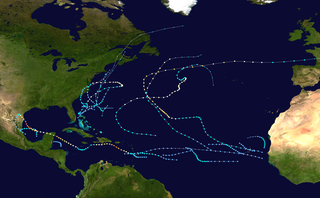
The 2000 Atlantic hurricane season was a fairly active hurricane season, but featured the latest first named storm in a hurricane season since 1992. The hurricane season officially began on June 1, and ended on November 30. It was slightly above average due to a La Niña weather pattern although most of the storms were weak. It was also the only season to have two of the storms affect Ireland. The first cyclone, Tropical Depression One, developed in the southern Gulf of Mexico on June 7 and dissipated after an uneventful duration. However, it would be almost two months before the first named storm, Alberto, formed near Cape Verde; Alberto also dissipated with no effects on land. Several other tropical cyclones—Tropical Depression Two, Tropical Depression Four, Chris, Ernesto, Nadine, and an unnamed subtropical storm—did not impact land. Five additional storms—Tropical Depression Nine, Florence, Isaac, Joyce, and Leslie—minimally affected land areas.

<span class="mw-page-title-main">1967 Atlantic hurricane season</span> Hurricane season in the Atlantic Ocean

The 1967 Atlantic hurricane season was an active Atlantic hurricane season overall, producing 13 nameable storms, of which 6 strengthened into hurricanes. The season officially began on June 1, 1967, and lasted until November 30, 1967. These dates, adopted by convention, historically describe the period in each year when most tropical cyclogenesis occurs in the Atlantic Ocean. The season's first system, Tropical Depression One, formed on June 10, and the last, Tropical Storm Heidi, lost tropical characteristics on November 2.

<span class="mw-page-title-main">1992 Atlantic hurricane season</span> Hurricane season in the Atlantic Ocean

The 1992 Atlantic hurricane season was a significantly below average season for overall tropical or subtropical cyclones as only ten formed. Six of them became named tropical storms, and four of those became hurricanes; one hurricane became a major hurricane. The season was also near-average in terms of accumulated cyclone energy. The season officially started on June 1 and officially ended on November 30. However, tropical cyclogenesis is possible at any time of the year, as demonstrated by formation in April of an unnamed subtropical storm in the central Atlantic.

<span class="mw-page-title-main">1970 Atlantic hurricane season</span> Hurricane season in the Atlantic Ocean

The 1970 Atlantic hurricane season officially began on June 1 and lasted until November 30. These dates conventionally delimit the period of each year when most tropical cyclones form in the Atlantic basin. The season was fairly average, with 14 named storms forming, of which seven were hurricanes. Two of those seven became major hurricanes, which are Category 3 or higher on the Saffir–Simpson scale. Also, this was the first season in which reconnaissance aircraft flew into all four quadrants of a tropical cyclone.

<span class="mw-page-title-main">1974 Atlantic hurricane season</span> Hurricane season in the Atlantic Ocean

The 1974 Atlantic hurricane season was a destructive and deadly hurricane season. In terms of overall activity, it was near average, with eleven named storms forming, of which four became hurricanes. Two of those four became major hurricanes, which are Category 3 or higher systems on the Saffir–Simpson scale. The season officially began on June 1 and lasted until November 30. These dates conventionally delimit the period of each year when most tropical cyclones form in the Atlantic Ocean.

<span class="mw-page-title-main">1976 Atlantic hurricane season</span> Hurricane season in the Atlantic Ocean

The 1976 Atlantic hurricane season was an fairly average Atlantic hurricane season in which 21 tropical or subtropical cyclones formed. 10 of them became nameable storms. Six of those reached hurricane strength, with two of the six became major hurricanes, which are Category 3 or higher on the Saffir–Simpson scale. The season officially began on June 1 and lasted until November 30. These dates conventionally delimit the period of each year when most tropical cyclones form in the Atlantic basin. However, the first system, a subtropical storm, developed in the Gulf of Mexico on May 21, several days before the official start of the season. The system spawned nine tornadoes in Florida, resulting in about $628,000 (1976 USD) in damage, though impact was minor otherwise.

<span class="mw-page-title-main">Hurricane Vince</span> Category 1 Atlantic hurricane in 2005

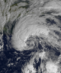
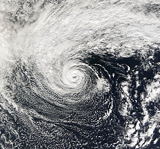
Hurricane Vince was an unusual hurricane that developed in the northeastern Atlantic basin. Forming in October during the 2005 Atlantic hurricane season, it strengthened over waters thought to be too cold for tropical development. Vince was the twentieth named tropical cyclone and twelfth hurricane of the extremely active season.

<span class="mw-page-title-main">Tropical Storm Nicholas (2003)</span> Atlantic tropical storm in 2003

Tropical Storm Nicholas was a long-lived tropical storm in October and November of the 2003 Atlantic hurricane season. Forming from a tropical wave on October 13 in the central tropical Atlantic Ocean, Nicholas developed slowly due to moderate levels of wind shear throughout its lifetime. Deep convection slowly organized, and Nicholas attained a peak intensity of 70 mph (110 km/h) on October 17. After moving west-northwestward for much of its lifetime, it turned northward and weakened due to increasing shear. The storm again turned to the west and briefly restrengthened, but after turning again to the north Nicholas transitioned to an extratropical cyclone on October 24. As an extratropical storm, Nicholas executed a large loop to the west, and after moving erratically for a week and organizing into a tropical low, it was absorbed by a non-tropical low. The low continued westward, crossed Florida, and ultimately dissipated over the Gulf Coast of the United States on November 5.

<span class="mw-page-title-main">Tropical cyclogenesis</span> Development and strengthening of a tropical cyclone in the atmosphere

Tropical cyclogenesis is the development and strengthening of a tropical cyclone in the atmosphere. The mechanisms through which tropical cyclogenesis occurs are distinctly different from those through which temperate cyclogenesis occurs. Tropical cyclogenesis involves the development of a warm-core cyclone, due to significant convection in a favorable atmospheric environment.

<span class="mw-page-title-main">2005 Azores subtropical storm</span> Unnamed Atlantic subtropical storm

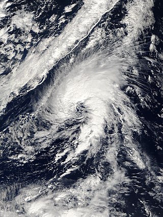
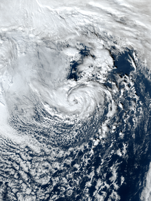
The 2005 Azores subtropical storm was the 19th nameable storm and only subtropical storm of the extremely active 2005 Atlantic hurricane season. It was not named by the National Hurricane Center as it was operationally classified as an extratropical low. It developed in the eastern Atlantic Ocean, an unusual region for late-season tropical cyclogenesis. Nonetheless, the system was able to generate a well-defined centre convecting around a warm core on 4 October. The system was short-lived, crossing over the Azores later on 4 October before becoming extratropical again on 5 October. No damages or fatalities were reported during that time. Its remnants were soon absorbed into a cold front. That system went on to become Hurricane Vince, which affected the Iberian Peninsula.

<span class="mw-page-title-main">Extratropical cyclone</span> Type of cyclone

Extratropical cyclones, sometimes called mid-latitude cyclones or wave cyclones, are low-pressure areas which, along with the anticyclones of high-pressure areas, drive the weather over much of the Earth. Extratropical cyclones are capable of producing anything from cloudiness and mild showers to severe gales, thunderstorms, blizzards, and tornadoes. These types of cyclones are defined as large scale (synoptic) low pressure weather systems that occur in the middle latitudes of the Earth. In contrast with tropical cyclones, extratropical cyclones produce rapid changes in temperature and dew point along broad lines, called weather fronts, about the center of the cyclone.

<span class="mw-page-title-main">2006 Central Pacific cyclone</span> Unusual cyclonic formation in the Pacific Ocean

The 2006 Central Pacific cyclone, also known as Invest 91C or Storm 91C, was an unusual weather system that formed in 2006. Forming on October 30 from a mid-latitude cyclone in the north Pacific mid-latitudes, it moved over waters warmer than normal. The system acquired some features more typical of subtropical and even tropical cyclones. However, as it neared the western coastline of North America, the system fell apart, dissipating soon after landfall, on November 4. Moisture from the storm's remnants caused substantial rainfall in British Columbia and the Pacific Northwest. The exact status and nature of this weather event is unknown, with meteorologists and weather agencies having differing opinions.

<span class="mw-page-title-main">Cold-core low</span> Cyclone with an associated cold pool of air at high altitude

A cold-core low, also known as an upper level low or cold-core cyclone, is a cyclone aloft which has an associated cold pool of air residing at high altitude within the Earth's troposphere, without a frontal structure. It is a low pressure system that strengthens with height in accordance with the thermal wind relationship. If a weak surface circulation forms in response to such a feature at subtropical latitudes of the eastern north Pacific or north Indian oceans, it is called a subtropical cyclone. Cloud cover and rainfall mainly occurs with these systems during the day.

<span class="mw-page-title-main">Glossary of tropical cyclone terms</span>

The following is a glossary of tropical cyclone terms.

<span class="mw-page-title-main">Subtropical Cyclone Katie</span> South Pacific subtropical cyclone in 2015

Subtropical Cyclone Katie, unofficially named by researchers, was an unusual weather event in early 2015. After the 2014–15 South Pacific cyclone season had officially ended, a rare subtropical cyclone was identified outside of the basin near Easter Island, during early May, and was unofficially dubbed Katie by researchers. Katie was one of the few tropical or subtropical systems ever observed forming in the far Southeast Pacific, outside of the official basin boundary of 120°W, which marks the eastern edge of RSMC Nadi's and RSMC Wellington's warning areas, during the satellite era. Due to the fact that this storm developed outside of the official areas of responsibility of the warning agencies in the South Pacific, the storm was not officially included as a part of the 2014–15 South Pacific cyclone season. However, the Chilean Navy Weather Service issued High Seas Warnings on the system as an extratropical low.

<span class="mw-page-title-main">Hurricane Alex (2016)</span> Category 1 Atlantic hurricane in 2016

Hurricane Alex was the first Atlantic hurricane to occur in January since Hurricane Alice of 1954–55. Alex originated as a non-tropical low near the Bahamas on January 7, 2016. Initially traveling northeast, the system passed by Bermuda on January 8 before turning southeast and deepening. It briefly acquired hurricane-force winds by January 10, then weakened slightly before curving towards the east and later northeast. Acquiring more tropical weather characteristics over time, the system transitioned into a subtropical cyclone well south of the Azores on January 12, becoming the first North Atlantic tropical or subtropical cyclone in January since Tropical Storm Zeta of 2005–2006. Alex continued to develop tropical features while turning north-northeast, and transitioned into a fully tropical cyclone on January 14. The cyclone peaked in strength as a Category 1 hurricane on the Saffir–Simpson scale (SSHWS), with maximum sustained winds of 85 mph and a central pressure of 981 mbar. Alex weakened to a high-end tropical storm before making landfall on Terceira Island on January 15. By that time, the storm was losing its tropical characteristics; it fully transitioned back into a non-tropical cyclone several hours after moving away from the Azores. Alex ultimately merged with another cyclone over the Labrador Sea on January 17.

<span class="mw-page-title-main">2021 Atlantic hurricane season</span> Hurricane season in the Atlantic Ocean

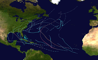
The 2021 Atlantic hurricane season was the third-most active Atlantic hurricane season on record in terms of number of tropical cyclones, although many of them were weak and short-lived. With 21 named storms forming, it became the second season in a row and third overall in which the designated 21-name list of storm names was exhausted. Seven of those storms strengthened into a hurricane, four of which reached major hurricane intensity, which is slightly above-average. The season officially began on June 1 and ended on November 30. These dates historically describe the period in each year when most Atlantic tropical cyclones form. However, subtropical or tropical cyclogenesis is possible at any time of the year, as demonstrated by the development of Tropical Storm Ana on May 22, making this the seventh consecutive year in which a storm developed outside of the official season.

<span class="mw-page-title-main">Subtropical Storm Alpha (2020)</span> Atlantic subtropical storm in 2020

Subtropical Storm Alpha was the first subtropical or tropical cyclone ever observed to make landfall in mainland Portugal. The twenty-second tropical or subtropical cyclone and twenty-first named storm of the extremely active and record-breaking 2020 Atlantic hurricane season, Alpha originated from a large non-tropical low that was first monitored by the National Hurricane Center on 15 September. Initially not anticipated to transition into a tropical cyclone, the low gradually tracked south-southeastward for several days with little development. By early on 17 September, the low had separated from its frontal features and exhibited sufficient organization to be classified as a subtropical cyclone, as it approached the Iberian Peninsula, becoming a subtropical storm around that time. Alpha then made landfall just south of Figueira da Foz, Portugal during the evening of 18 September, then rapidly weakened as it moved over the mountainous terrain of Northeastern Portugal. The system degenerated into a remnant low on 19 September, when it was last noted.

References

  1. 1 2 Mark P. Guishard; Jenni L. Evans; Robert E. Hart (July 2009). "Atlantic Subtropical Storms. Part II: Climatology". Journal of Climate. 22 (13): 3574–3594. Bibcode:2009JCli...22.3574G. doi: 10.1175/2008JCLI2346.1 . S2CID   51435473.
  2. 1 2 Jenni L. Evans; Mark P. Guishard (July 2009). "Atlantic Subtropical Storms. Part I: Diagnostic Criteria and Composite Analysis". Monthly Weather Review. 137 (7): 2065–2080. Bibcode:2009MWRv..137.2065E. doi: 10.1175/2009MWR2468.1 .
  3. Tory, K. J.; Dare, R. A. (2015-10-15). "Sea Surface Temperature Thresholds for Tropical Cyclone Formation". Journal of Climate. 28 (20): 8171–8183. Bibcode:2015JCli...28.8171T. doi: 10.1175/JCLI-D-14-00637.1 . ISSN   0894-8755. S2CID   140543585.
  4. 1 2 3 Jenni L. Evans; Aviva J. Braun (November 2012). "A climatology of subtropical cyclones in the south Atlantic". Journal of Climate. 25 (21): 7328–7340. Bibcode:2012JCli...25.7328E. doi: 10.1175/JCLI-D-11-00212.1 .
  5. David B. Spiegler (1973). Many times, subtropical cyclones have a small warm core. Reply. Archived 2009-02-25 at the Wayback Machine Monthly Weather Review, April 1973, p. 380. Retrieved on 2008-04-20.
  6. 1 2 R. H. Simpson and Paul J. Hebert (1973). Atlantic Hurricane Season of 1972. Archived 2011-05-25 at the Wayback Machine Monthly Weather Review, April 1973, pp. 323–332. Retrieved on 2008-06-14.
  7. "Definition of NEUTERCANE". www.merriam-webster.com. Archived from the original on 2022-04-18. Retrieved 2022-04-18.
  8. Weatherwise (2006). Heldref Publications. March/April 2006, p. 64.
  9. James Franklin (2001). Subtropical Storm One Public Advisory from 2001. Archived 2005-09-20 at the Wayback Machine National Hurricane Center Retrieved on 2007-05-05.
  10. Jack Beven and Eric S. Blake (2006). Unnamed Subtropical Storm. National Hurricane Center. Retrieved on 2007-05-05.
  11. 1 2 World Meteorological Organization (2006). TROPICAL CYCLONE OPERATIONAL PLAN FOR THE SOUTH-WEST INDIAN OCEAN: 2006 Edition. pp. I-3, I-9. Retrieved on 2009-02-28.
  12. "Normas Da Autoridade Marítima Para As Atividades De Meteorologia Marítima" (PDF) (in Portuguese). Brazilian Navy. 2011. Archived from the original (PDF) on 6 February 2015. Retrieved 6 February 2015.
  13. 1 2 Chris Landsea. Subject: A6) What is a sub-tropical cyclone? Archived 2016-06-03 at the Wayback Machine National Hurricane Center. Retrieved on 2008-06-14.
  14. Mark A. Lander (2004). 7A.5 Monsoon Depressions, Monsoon Gyres, Midget Tropical Cyclones, TUTT Cells, and High Intensity After Recurvature: Lessons Learned From Use of Dvorak's Techniques in the World's Most Prolific Tropical-Cyclone Basin. Archived 2009-03-19 at the Wayback Machine American Meteorological Society. Retrieved on 2009-02-28.
  15. 1 2 S. Hastenrath (1991). Climate Dynamics of the Tropics. Archived 2024-01-28 at the Wayback Machine Springer, pp 244. ISBN   978-0-7923-1346-5. Retrieved on 2009-02-29.
  16. "What Is a Subtropical Storm and How Is It Different From a Tropical Storm? | The Weather Channel - Articles from The Weather Channel | weather.com". The Weather Channel. Archived from the original on 2022-06-02. Retrieved 2022-04-18.
  17. 1 2 David Mark Roth (2002-02-15). "A Fifty-year History of Subtropical Cyclones" (PDF). Hydrometeorological Prediction Center. Archived (PDF) from the original on 2021-04-17. Retrieved 2006-10-04.
  18. Mark P. Guishard; Elizabeth A. Nelson; Jenni L. Evans; Robert E. Hart; Dermott G. O’Connell (August 2007). "Bermuda subtropical storms". Meteorology and Atmospheric Physics. 97 (1–4): 239–253. Bibcode:2007MAP....97..239G. doi:10.1007/s00703-006-0255-y. S2CID   120260805.
  19. Diamond, Howard J (August 25, 2015). "Review of the 2014/15 Tropical Cyclone Season in the Southwest Pacific Ocean Basin". Climate Program Office. National Oceanic and Atmospheric Administration. Archived from the original on February 9, 2022. Retrieved October 16, 2017.
  20. Jonathan Belles (May 9, 2018). "Extremely Rare Southeast Pacific Subtropical Cyclone Forms Off the Chilean Coast". The Weather Channel. Archived from the original on June 4, 2022. Retrieved May 10, 2018.
  21. Steve Young (5 July 2018). "Monthly Global Tropical Cyclone Tracks - May 2018". Australia Severe Weather. Archived from the original on 4 September 2018. Retrieved 3 September 2018.
  22. "South American Forecast Discussion". Weather Prediction Center . 12 January 2022. Archived from the original on 15 January 2022. Retrieved 15 January 2022.{{cite web}}: CS1 maint: bot: original URL status unknown (link)
  23. "South American Forecast Discussion". Weather Prediction Center . 13 January 2022. Archived from the original on 15 January 2022. Retrieved 15 January 2022.{{cite web}}: CS1 maint: bot: original URL status unknown (link)
  24. National Hurricane Center (2009). Glossary of NHC terms. Archived 2012-09-27 at the Wayback Machine Retrieved on 2007-05-05.
  25. Robert E. Hart (April 2003). "A Cyclone Phase Space Derived from Thermal Wind and Thermal Asymmetry". Monthly Weather Review. 131 (4): 585–616. Bibcode:2003MWRv..131..585H. doi: 10.1175/1520-0493(2003)131<0585:ACPSDF>2.0.CO;2 . S2CID   3753455.
  26. Robert Hart (2003). Cyclone Phase Analysis and Forecast: Help Page. Archived 2012-05-28 at the Wayback Machine EUMeTrain. Retrieved on 2009-03-01.
  27. Masters, Jeff. "Tropical, subtropical, extratropical?". Weather Underground. Archived from the original on 30 August 2018. Retrieved 4 August 2017.
  28. "Atlantic hurricane best track (HURDAT version 2)" (Database). United States National Hurricane Center. April 5, 2023. Retrieved May 17, 2024.PD-icon.svg This article incorporates text from this source, which is in the public domain.
  29. Kenneth R. Knapp; Michael C. Kruk; David H. Levinson; Howard J. Diamond; Charles J. Neumann (2010). 2001 1120002001:HSK2201 (2001171S35037). The International Best Track Archive for Climate Stewardship (IBTrACS): Unifying tropical cyclone best track data (Report). Bulletin of the American Meteorological Society. Archived from the original on 2016-03-05. Retrieved 2023-07-09.
  30. 1 2 3 4 5 6 7 8 National Hurricane Center (2017). Atlantic Hurricane Database (HURDAT2). Archived 2017-07-12 at the Wayback Machine Retrieved on 2017-04-24.
  31. Henson, Bob; Masters, Jeff Masters (December 6, 2022). "Post-season action possible in the North Atlantic". New Haven, Connecticut: Yale Climate Connections. Archived from the original on December 9, 2022. Retrieved December 9, 2022.
  32. National Hurricane Center (2009). Glossary of NHC Terms. Archived 2012-09-27 at the Wayback Machine Retrieved on 2009-02-07.
  33. Neal Dorst (2007). Subject: A18) What is a neutercane? Archived 2009-01-15 at the Wayback Machine Hurricane Research Division. Retrieved on 2009-02-07.
  34. Ian Morrison and Steven Businger (2002). SYNOPTIC STRUCTURE AND EVOLUTION OF A KONA LOW. Archived 2007-05-27 at the Wayback Machine University of Hawaiʻi. Retrieved on 2007-05-22.
  35. 1 2 Leslie, Lance M.; Speer, Milton S. (1998). "Short-Range Ensemble Forecasting of Explosive Australian East Coast Cyclogenesis". Weather and Forecasting. 13 (3): 822–832. Bibcode:1998WtFor..13..822L. doi: 10.1175/1520-0434(1998)013<0822:SREFOE>2.0.CO;2 .
  36. Dowdy, Andrew J.; Graham A. Mills; Bertrand Timbal; Yang Wang (February 2013). "Changes in the Risk of Extratropical Cyclones in Eastern Australia". Journal of Climate. 26 (4): 1403–1417. Bibcode:2013JCli...26.1403D. doi: 10.1175/JCLI-D-12-00192.1 .
  37. Dowdy, Andrew J.; Graham A. Mills; Bertrand Timbal (2011). "Large-scale indicators of Australian East Coast Lows and associated extreme weather events" (PDF). In Day K. A. (ed.). CAWCR technical report; 37. CSIRO and the Bureau of Meteorology. ISBN   978-1-921826-36-8. Archived from the original (PDF) on 11 April 2013. Retrieved 7 April 2013.
  38. 1 2 Holland, Greg J.; Lynch, Amanda H.; Leslie, Lance M. (1987). "Australian East-Coast Cyclones. Part I: Synoptic Overview and Case Study". Monthly Weather Review. 115 (12): 3024–3036. Bibcode:1987MWRv..115.3024H. doi: 10.1175/1520-0493(1987)115<3024:AECCPI>2.0.CO;2 .
  39. Lim, Eun-Pa; Simmonds, Ian (2002). "Explosive Cyclone Development in the Southern Hemisphere and a Comparison with Northern Hemisphere Events". Monthly Weather Review. 130 (9): 2188–2209. Bibcode:2002MWRv..130.2188L. doi: 10.1175/1520-0493(2002)130<2188:ECDITS>2.0.CO;2 .
  40. "About East Coast Lows". Bureau of Meteorology. Archived from the original on 2 April 2013. Retrieved 6 April 2013.
  41. "Australian East Coast Storm 2007: Impact of East Coast Lows". Guy Carpenter. October 2007. Archived from the original on 28 January 2024. Retrieved 7 April 2013.
  42. Hopkins, Linda C.; Holland, Greg J. (1997). "Australian Heavy-Rain Days and Associated East Coast Cyclones: 1958–92". Journal of Climate. 10 (4): 621–635. Bibcode:1997JCli...10..621H. doi: 10.1175/1520-0442(1997)010<0621:AHRDAA>2.0.CO;2 .