Horse latitudes

Last updated

A diagram showing the relative positions of the horse latitudes Atmospheric circulation.svg
A diagram showing the relative positions of the horse latitudes

The horse latitudes are the latitudes about 30 degrees north and south of the Equator. [1] They are characterized by sunny skies, calm winds, and very little precipitation. They are also known as subtropical ridges or highs. It is a high-pressure area at the divergence of trade winds and the westerlies.

Contents

Origin of the term

A likely and documented explanation is that the term is derived from the "dead horse" ritual of seamen (see Beating a dead horse). In this practice, the seaman paraded a straw-stuffed effigy of a horse around the deck before throwing it overboard. Seamen were paid partly in advance before a long voyage, and they frequently spent their pay all at once, resulting in a period of time without income. If they got advances from the ship's paymaster, they would incur debt. This period was called the "dead horse" time, and it usually lasted a month or two. The seaman's ceremony was to celebrate having worked off the "dead horse" debt. As west-bound shipping from Europe usually reached the subtropics at about the time the "dead horse" was worked off, the latitude became associated with the ceremony. [2]

An alternative theory, of sufficient popularity to serve as an example of folk etymology, is that the term horse latitudes originates from when the Spanish transported horses by ship to their colonies in the West Indies and Americas. Ships often became becalmed in mid-ocean in this latitude, thus severely prolonging the voyage; the resulting water shortages made it impossible for the crew to keep the horses alive, and they would throw the dead or dying animals overboard. [3]

A third explanation, which simultaneously explains both the northern and southern horse latitudes and does not depend on the length of the voyage or the port of departure, is based on maritime terminology: a ship was said to be 'horsed' when, although there was insufficient wind for sail, the vessel could make good progress by latching on to a strong current. This was suggested by Edward Taube in his article "The Sense of 'Horse' in the Horse Latitudes" ( Journal of Geography , October 1967). [4] He argued the maritime use of 'horsed' described a ship that was being carried along by an ocean current or tide in the manner of a rider on horseback. The term had been in use since the end of the seventeenth century. Furthermore, The India Directory in its entry for Fernando de Noronha, an island off the coast of Brazil, mentions it had been visited frequently by ships "occasioned by the currents having horsed them to the westward". [5]

Formation

The heating of the earth at the thermal equator leads to large amounts of convection along the Intertropical Convergence Zone. This air mass rises and then diverges, moving away from the equator in both northerly and southerly directions. As the air moves towards the mid-latitudes on both sides of the equator, it cools and sinks. This creates a ridge of high pressure near the 30th parallel in both hemispheres. At the surface level, the sinking air diverges again with some returning to the equator, creating the Hadley cell [6] which during summer is reinforced by other climatological mechanisms such as the Rodwell–Hoskins mechanism. [7] [8] Many of the world's deserts are caused by these climatological high-pressure areas.

The subtropical ridge moves poleward during the summer, reaching its highest latitude in early autumn, before moving back during the cold season. The El Niño–Southern Oscillation (ENSO) can displace the northern hemisphere subtropical ridge, with La Niña allowing for a more northerly axis for the ridge, while El Niños show flatter, more southerly ridges. The change of the ridge position during ENSO cycles changes the tracks of tropical cyclones that form around their equatorward and western peripheries. As the subtropical ridge varies in position and strength, it can enhance or depress monsoon regimes around their low-latitude periphery.

The horse latitudes are associated with the subtropical anticyclone. The belt in the Northern Hemisphere is sometimes called the "calms of Cancer" and that in the Southern Hemisphere the "calms of Capricorn".

The consistently warm, dry, and sunny conditions of the horse latitudes are the main cause for the existence of the world's major hot deserts, such as the Sahara Desert in Africa, the Arabian and Syrian deserts in the Middle East, the Mojave and Sonoran deserts in the southwestern United States and northern Mexico, all in the Northern Hemisphere; and the Atacama Desert, the Namib Desert, the Kalahari Desert, and the Australian Desert in the Southern Hemisphere.

Migration

The subtropical ridge shows up as a large area of black (dryness) on this water vapor satellite image from September 2000. Subtropicalridge2000091412.jpg
The subtropical ridge shows up as a large area of black (dryness) on this water vapor satellite image from September 2000.

The subtropical ridge starts migrating poleward in late spring reaching its zenith in early autumn before retreating equatorward during the late fall, winter, and early spring. The equatorward migration of the subtropical ridge during the cold season is due to increasing north-south temperature differences between the poles and tropics. [9] The latitudinal movement of the subtropical ridge is strongly correlated with the progression of the monsoon trough or Intertropical Convergence Zone.

Most tropical cyclones form on the side of the subtropical ridge closer to the equator, then move poleward past the ridge axis before recurving into the main belt of the Westerlies. [10] When the subtropical ridge shifts due to ENSO, so will the preferred tropical cyclone tracks. Areas west of Japan and Korea tend to experience far fewer September–November tropical cyclone impacts during El Niño and neutral years, while mainland China experiences much greater landfall frequency during La Niña years. During El Niño years, the break[ clarification needed ] in the subtropical ridge tends to lie near 130°E, which would favor the Japanese archipelago, while in La Niña years the formation of tropical cyclones, along with the subtropical ridge position, shift west, which increases the threat to China. [11] In the Atlantic basin, the subtropical ridge position tends to lie about 5 degrees farther south during El Niño years, which leads to a more southerly recurvature for tropical cyclones during those years.

When the Atlantic multidecadal oscillation's mode is favorable to tropical cyclone development (1995–present), it amplifies the subtropical ridge across the central and eastern Atlantic. [12]

Role in weather formation and air quality

Mean July subtropical ridge position Subtropridgejulyna.gif
Mean July subtropical ridge position

When the subtropical ridge in the northwest Pacific is stronger than normal, it leads to a wet monsoon season for Asia. [13] The subtropical ridge position is linked to how far northward monsoon moisture and thunderstorms extend into the United States. The subtropical ridge across North America typically migrates far enough northward to begin monsoon conditions across the Desert Southwest from July to September. [14] When the subtropical ridge is farther north than normal towards the Four Corners, monsoon thunderstorms can spread northward into Arizona. When the high pressure moves south, its circulation cuts off the moisture, and the hot, dry continental airmass returns from the northwest, and therefore the atmosphere dries out across the Desert Southwest, causing a break in the monsoon regime. [15]

In summer, On the subtropical ridge's western edge (generally on the eastern coast of continents), the high-pressure cell pushes poleward a southerly flow (northerly in the southern hemisphere) of tropical air. In the United States, the subtropical ridge Bermuda High helps create the hot, sultry summers with daily thunderstorms with buoyant airmasses typical of the Gulf of Mexico and the East Coast of the United States. This flow pattern also occurs on the eastern coasts of continents in other subtropical climates such as South China, southern Japan, central-eastern South America Pampas, southern Queensland and, KwaZulu-Natal province in South Africa. [16]

When surface winds become light, the subsidence produced directly under the subtropical ridge can lead to a buildup of particulates in urban areas under the ridge, leading to widespread haze. [17] If the low-level relative humidity rises towards 100 percent overnight, fog can form. [18]

See also

Related Research Articles

<span class="mw-page-title-main">Jet stream</span> Fast-flowing atmospheric air current

Jet streams are fast flowing, narrow, meandering air currents in the atmospheres of the Earth, Venus, Jupiter, Saturn, Uranus, and Neptune. On Earth, the main jet streams are located near the altitude of the tropopause and are westerly winds. Jet streams may start, stop, split into two or more parts, combine into one stream, or flow in various directions including opposite to the direction of the remainder of the jet.

<span class="mw-page-title-main">Tropics</span> Region of Earth surrounding the Equator

The tropics are the regions of Earth surrounding the Equator. They are defined in latitude by the Tropic of Cancer in the Northern Hemisphere at 23°26′10.2″ (or 23.43616°) N and the Tropic of Capricorn in the Southern Hemisphere at 23°26′10.2″ (or 23.43616°) S. The tropics are also referred to as the tropical zone and the torrid zone.

<span class="mw-page-title-main">Anticyclone</span> Weather phenomenon of high pressure, as opposed to a cyclone

An anticyclone is a weather phenomenon defined as a large-scale circulation of winds around a central region of high atmospheric pressure, clockwise in the Northern Hemisphere and counterclockwise in the Southern Hemisphere as viewed from above. Effects of surface-based anticyclones include clearing skies as well as cooler, drier air. Fog can also form overnight within a region of higher pressure.

<span class="mw-page-title-main">Subtropics</span> Geographic and climate zone

The subtropical zones or subtropics are geographical and climate zones to the north and south of the tropics. Geographically part of the temperate zones of both hemispheres, they cover the middle latitudes from 23°26′10.2″ (or 23.43616°) to approximately 35° north and south. The horse latitudes lie within this range.

<span class="mw-page-title-main">Intertropical Convergence Zone</span> Meteorological phenomenon

The Intertropical Convergence Zone, known by sailors as the doldrums or the calms because of its monotonous windless weather, is the area where the northeast and the southeast trade winds converge. It encircles Earth near the thermal equator though its specific position varies seasonally. When it lies near the geographic Equator, it is called the near-equatorial trough. Where the ITCZ is drawn into and merges with a monsoonal circulation, it is sometimes referred to as a monsoon trough.

<span class="mw-page-title-main">Atmospheric circulation</span> Process which distributes thermal energy about the Earths surface

Atmospheric circulation is the large-scale movement of air and together with ocean circulation is the means by which thermal energy is redistributed on the surface of the Earth. The Earth's atmospheric circulation varies from year to year, but the large-scale structure of its circulation remains fairly constant. The smaller-scale weather systems – mid-latitude depressions, or tropical convective cells – occur chaotically, and long-range weather predictions of those cannot be made beyond ten days in practice, or a month in theory.

<span class="mw-page-title-main">High-pressure area</span> Region with higher atmospheric pressure

A high-pressure area, high, or anticyclone, is an area near the surface of a planet where the atmospheric pressure is greater than the pressure in the surrounding regions. Highs are middle-scale meteorological features that result from interplays between the relatively larger-scale dynamics of an entire planet's atmospheric circulation.

<span class="mw-page-title-main">Low-pressure area</span> Area with air pressures lower than adjacent areas

In meteorology, a low-pressure area, low area or low is a region where the atmospheric pressure is lower than that of surrounding locations. Low-pressure areas are commonly associated with inclement weather, while high-pressure areas are associated with lighter winds and clear skies. Winds circle anti-clockwise around lows in the northern hemisphere, and clockwise in the southern hemisphere, due to opposing Coriolis forces. Low-pressure systems form under areas of wind divergence that occur in the upper levels of the atmosphere (aloft). The formation process of a low-pressure area is known as cyclogenesis. In meteorology, atmospheric divergence aloft occurs in two kinds of places:

<span class="mw-page-title-main">Trade winds</span> Equatorial east-to-west prevailing winds

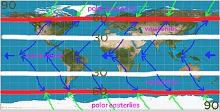
The trade winds or easterlies are the permanent east-to-west prevailing winds that flow in the Earth's equatorial region. The trade winds blow mainly from the northeast in the Northern Hemisphere and from the southeast in the Southern Hemisphere, strengthening during the winter and when the Arctic oscillation is in its warm phase. Trade winds have been used by captains of sailing ships to cross the world's oceans for centuries. They enabled European colonization of the Americas, and trade routes to become established across the Atlantic Ocean and the Pacific Ocean.

<span class="mw-page-title-main">Prevailing winds</span> Strongest direction of wind on a region of Earths surface

In meteorology, prevailing wind in a region of the Earth's surface is a surface wind that blows predominantly from a particular direction. The dominant winds are the trends in direction of wind with the highest speed over a particular point on the Earth's surface at any given time. A region's prevailing and dominant winds are the result of global patterns of movement in the Earth's atmosphere. In general, winds are predominantly easterly at low latitudes globally. In the mid-latitudes, westerly winds are dominant, and their strength is largely determined by the polar cyclone. In areas where winds tend to be light, the sea breeze/land breeze cycle is the most important cause of the prevailing wind; in areas which have variable terrain, mountain and valley breezes dominate the wind pattern. Highly elevated surfaces can induce a thermal low, which then augments the environmental wind flow.

<span class="mw-page-title-main">Westerlies</span> Prevailing winds from the west

The westerlies, anti-trades, or prevailing westerlies, are prevailing winds from the west toward the east in the middle latitudes between 30 and 60 degrees latitude. They originate from the high-pressure areas in the horse latitudes and trend towards the poles and steer extratropical cyclones in this general manner. Tropical cyclones which cross the subtropical ridge axis into the westerlies recurve due to the increased westerly flow. The winds are predominantly from the southwest in the Northern Hemisphere and from the northwest in the Southern Hemisphere.

The South Pacific Convergence Zone (SPCZ), a reverse-oriented monsoon trough, is a band of low-level convergence, cloudiness and precipitation extending from the Western Pacific Warm Pool at the maritime continent south-eastwards towards French Polynesia and as far as the Cook Islands. The SPCZ is a portion of the Intertropical Convergence Zone (ITCZ) which lies in a band extending east–west near the Equator but can be more extratropical in nature, especially east of the International Date Line. It is considered the largest and most important piece of the ITCZ, and has the least dependence upon heating from a nearby landmass during the summer than any other portion of the monsoon trough. The SPCZ can affect the precipitation on Polynesian islands in the southwest Pacific Ocean, so it is important to understand how the SPCZ behaves with large-scale, global climate phenomenon, such as the ITCZ, El Niño–Southern Oscillation, and the Interdecadal Pacific oscillation (IPO), a portion of the Pacific decadal oscillation.

<span class="mw-page-title-main">Madden–Julian oscillation</span> Tropical atmosphere element of variability

The Madden–Julian oscillation (MJO) is the largest element of the intraseasonal variability in the tropical atmosphere. It was discovered in 1971 by Roland Madden and Paul Julian of the American National Center for Atmospheric Research (NCAR). It is a large-scale coupling between atmospheric circulation and tropical deep atmospheric convection. Unlike a standing pattern like the El Niño–Southern Oscillation (ENSO), the Madden–Julian oscillation is a traveling pattern that propagates eastward, at approximately 4 to 8 m/s, through the atmosphere above the warm parts of the Indian and Pacific oceans. This overall circulation pattern manifests itself most clearly as anomalous rainfall.

The North Equatorial Current (NEC) is a westward wind-driven current mostly located near the equator, but the location varies from different oceans. The NEC in the Pacific and the Atlantic is about 5°-20°N, while the NEC in the Indian Ocean is very close to the equator. It ranges from the sea surface down to 400 m in the western Pacific.

<span class="mw-page-title-main">Hadley cell</span> Tropical atmospheric circulation feature

The Hadley cell, also known as the Hadley circulation, is a global-scale tropical atmospheric circulation that features air rising near the equator, flowing poleward near the tropopause at a height of 12–15 km (7.5–9.3 mi) above the Earth's surface, cooling and descending in the subtropics at around 25 degrees latitude, and then returning equatorward near the surface. It is a thermally direct circulation within the troposphere that emerges due to differences in insolation and heating between the tropics and the subtropics. On a yearly average, the circulation is characterized by a circulation cell on each side of the equator. The Southern Hemisphere Hadley cell is slightly stronger on average than its northern counterpart, extending slightly beyond the equator into the Northern Hemisphere. During the summer and winter months, the Hadley circulation is dominated by a single, cross-equatorial cell with air rising in the summer hemisphere and sinking in the winter hemisphere. Analogous circulations may occur in extraterrestrial atmospheres, such as on Venus and Mars.

<span class="mw-page-title-main">Monsoon trough</span> Weather phenomenon

The monsoon trough is a portion of the Intertropical Convergence Zone in the Western Pacific, as depicted by a line on a weather map showing the locations of minimum sea level pressure, and as such, is a convergence zone between the wind patterns of the southern and northern hemispheres.

<span class="mw-page-title-main">Tropical cyclogenesis</span> Development and strengthening of a tropical cyclone in the atmosphere

Tropical cyclogenesis is the development and strengthening of a tropical cyclone in the atmosphere. The mechanisms through which tropical cyclogenesis occurs are distinctly different from those through which temperate cyclogenesis occurs. Tropical cyclogenesis involves the development of a warm-core cyclone, due to significant convection in a favorable atmospheric environment.

<span class="mw-page-title-main">South Atlantic High</span> Semipermanent anticyclone over the Atlantic Ocean

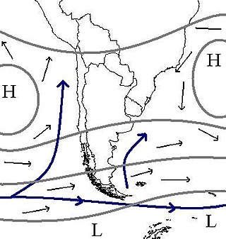
South Atlantic High is a semipermanent pressure high centered at about 25°S, 15°W, in the Atlantic Ocean. It is also called the St. Helena High, Saint Helena island being the only land in the area. It can stretch thousands of miles across the South Atlantic. This does not mean that the position and the intensity of this anticyclone are permanent, but just that there is an anticyclone on the maps describing the average monthly pressure. This area of high pressure is part of the great subtropical belt of anticyclones called the subtropical ridge. The centre of the high pressure region tends to follow the seasonal variation in position of the sun, moving south in the southern summer and north in the southern winter. This affects the climate of the adjacent continental areas, bringing seasonal changes to the climate and weather as the position of the high oscillates.

<span class="mw-page-title-main">Earth rainfall climatology</span> Study of rainfall

Earth rainfall climatology Is the study of rainfall, a sub-field of meteorology. Formally, a wider study includes water falling as ice crystals, i.e. hail, sleet, snow. The aim of rainfall climatology is to measure, understand and predict rain distribution across different regions of planet Earth, a factor of air pressure, humidity, topography, cloud type and raindrop size, via direct measurement and remote sensing data acquisition. Current technologies accurately predict rainfall 3–4 days in advance using numerical weather prediction. Geostationary orbiting satellites gather IR and visual wavelength data to measure realtime localised rainfall by estimating cloud albedo, water content, and the corresponding probability of rain.

<span class="mw-page-title-main">Climate of Asia</span> Overview of the climate of Asia

The climate of Asia is dry across its southwestern region, with dry across much of the interior. Some of the largest daily temperature ranges on Earth occur in the western part of Asia. The monsoon circulation dominates across the southern and eastern regions, due to the Himalayas forcing the formation of a thermal low which draws in moisture during the summer. The southwestern region of the continent experiences low relief as a result of the subtropical high pressure belt; they are hot in summer, warm to cool in winter, and may snow at higher altitudes. Siberia is one of the coldest places in the Northern Hemisphere, and can act as a source of arctic air mass for North America. The most active place on Earth for tropical cyclone activity lies northeast of the Philippines and south of Japan, and the phase of the El Nino-Southern Oscillation modulates where in Asia landfall is more likely to occur. Many parts of Asia are being impacted by climate change.

References

  1. US Department of Commerce, National Oceanic and Atmospheric Administration. "What are the Horse Latitudes?". oceanservice.noaa.gov. Retrieved April 17, 2021.
  2. Kemp, Peter. The Oxford Companion to Ships and the Sea, London, Oxford University Press, 1976. pp. 233, 399
  3. The Columbia Electronic Encyclopedia, Sixth Edition. New York: Columbia University Press, 2003
  4. "World Wide Words". 2008.
  5. Horsburgh, James (1836). "Fernando de Noronha". India Directory, or, Directions for Sailing to and from the East Indies, China, Australia, Cape of Good Hope, Brazil and the Interjacent Ports... London: W. H. Allen. p. 31.
  6. Owen E. Thompson. "Hadley Circulation Cell". Archived March 5, 2009, at the Wayback Machine .
  7. Rodwell, M. J.; Hoskins, B. J. (August 1, 2001). "Subtropical Anticyclones and Summer Monsoons". Journal of Climate. 14 (15): 3192–3211. Bibcode: 2001JCli...14.3192R . doi: 10.1175/1520-0442(2001)014<3192:SAASM>2.0.CO;2 . ISSN   0894-8755. S2CID   58891085 .
  8. Channel Video Productions. Retrieved on February 11, 2007.
  9. Roger Graham Barry, Richard J. Chorley (1992). Atmosphere, weather, and climate . Routledge. p.  117. ISBN   978-0-415-07760-6 . Retrieved November 9, 2009. Atmosphere, weather, and climate.
  10. "3.3 JTWC Forecasting Philosophies" (PDF). Joint Typhoon Warning Center. United States Navy. 2006. Archived from the original (PDF) on July 5, 2012. Retrieved February 11, 2007.
  11. Wu, M. C.; Chang, W. L.; Leung, W. M. (March 2004). "Impacts of El Nino-Southern Oscillation Events on Tropical Cyclone Landfalling Activity in the Western North Pacific". Journal of Climate. 17 (6): 1419–1428. Bibcode:2004JCli...17.1419W. doi: 10.1175/1520-0442(2004)017<1419:IOENOE>2.0.CO;2 .
  12. Bell, Gerald; Chelliah, Muthuvel; Mo, Kingste; Goldenberg, Stanley; Landsea, Christopher; Blake, Eric; Pasch, Richard (May 17, 2004). "NOAA: 2004 Atlantic Hurricane Outlook". Climate Prediction Center . Archived from the original on January 1, 2019. Retrieved February 11, 2007.
  13. C.-P. Chang, Yongsheng Zhang, and Tim Li (1999). Interannual and Interdecadal Variations of the East Asian Summer Monsoon and Tropical Pacific SSTs. Part I: Roles of the Subtropical Ridge. Journal of Climate: pp. 4310–4325. Retrieved on February 11, 2007.
  14. Arizona State University (2009). Basics of the Arizona Monsoon & Desert Meteorology. Archived May 31, 2009, at the Wayback Machine Retrieved on February 11, 2007.
  15. David K. Adams (2009). Review of Variability in the North American Monsoon. United States Geological Survey. Retrieved on February 11, 2007.
  16. Adelson, Glen; Environment: An Interdisciplinary Anthology, pp. 466–467 ISBN   0300110774
  17. Myanmar government (2007). Haze. Archived February 24, 2008, at the Wayback Machine Retrieved on February 11, 2007.
  18. Robert Tardif (2002). Fog characteristics. Archived May 20, 2011, at the Wayback Machine University Corporation for Atmospheric Research. Retrieved on February 11, 2007.

Further reading