
A blizzard is a severe snowstorm characterized by strong sustained winds and low visibility, lasting for a prolonged period of time—typically at least three or four hours. A ground blizzard is a weather condition where snow is not falling but loose snow on the ground is lifted and blown by strong winds. Blizzards can have an immense size and usually stretch to hundreds or thousands of kilometres.
A storm is any disturbed state of the natural environment or the atmosphere of an astronomical body. It may be marked by significant disruptions to normal conditions such as strong wind, tornadoes, hail, thunder and lightning, heavy precipitation, heavy freezing rain, strong winds, wind transporting some substance through the atmosphere such as in a dust storm, among other forms of severe weather.

NEXRAD or Nexrad is a network of 159 high-resolution S-band Doppler weather radars operated by the National Weather Service (NWS), an agency of the National Oceanic and Atmospheric Administration (NOAA) within the United States Department of Commerce, the Federal Aviation Administration (FAA) within the Department of Transportation, and the U.S. Air Force within the Department of Defense. Its technical name is WSR-88D.

A nor'easter, is a large-scale extratropical cyclone in the western North Atlantic Ocean. The name derives from the direction of the winds that blow from the northeast. The term is commonly used in the winter in New England and Atlantic Canada.

A perfect storm is a meteorological event aggravated by a rare combination of circumstances. The term is used by analogy to an unusually severe storm that results from a rare combination of meteorological phenomena.
The Storm of the century is a term usually applied to a particularly damaging or notable weather event during a specific century. It may refer to:

The 53rd Weather Reconnaissance Squadron, also known by its nickname, Hurricane Hunters, is a flying unit of the United States Air Force, and "the only Department of Defense organization still flying into tropical storms and hurricanes." Aligned under the 403rd Wing of the Air Force Reserve Command (AFRC) and based at Keesler Air Force Base, Mississippi, with ten aircraft, it flies into tropical cyclones in the Atlantic Ocean, the Caribbean Sea, the Gulf of Mexico and the Central Pacific Ocean for the specific purpose of directly measuring weather data in and around those storms. The 53rd WRS currently operates the Lockheed WC-130J aircraft as its weather data collection platform.

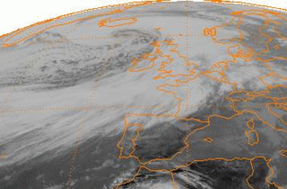
The 1993 Storm of the Century was a cyclonic storm that formed over the Gulf of Mexico on March 12, 1993. The cold weather, heavy snowfall, high winds and storm surges that the storm brought affected a very large area; at its height, it stretched from Canada to Honduras. The cyclone moved through the Gulf of Mexico and then through the eastern United States before moving on to eastern Canada. It eventually dissipated in the North Atlantic Ocean on March 15.

Tropical cyclones are ranked on one of five tropical cyclone intensity scales, according to their maximum sustained winds and which tropical cyclone basins they are located in. Only a few scales of classifications are used officially by the meteorological agencies monitoring the tropical cyclones, but other scales also exist, such as accumulated cyclone energy, the Power Dissipation Index, the Integrated Kinetic Energy Index, and the Hurricane Severity Index.

The Great Appalachian Storm of November 1950 was a large extratropical cyclone which moved through the Eastern United States, causing blizzard conditions along the western slopes of the Appalachian Mountains and significant winds and heavy rainfall east of the mountains. Hurricane-force winds, peaking at 110 miles per hour (180 km/h) in Concord, New Hampshire, and 160 mph (260 km/h) in the highlands of New England, disrupted power to 1 million customers during the event.

Extratropical cyclones, sometimes called mid-latitude cyclones or wave cyclones, are low-pressure areas which, along with the anticyclones of high-pressure areas, drive the weather over much of the Earth. Extratropical cyclones are capable of producing anything from cloudiness and mild showers to severe gales, thunderstorms, blizzards, and tornadoes. These types of cyclones are defined as large scale (synoptic) low pressure weather systems that occur in the middle latitudes of the Earth. In contrast with tropical cyclones, extratropical cyclones produce rapid changes in temperature and dew point along broad lines, called weather fronts, about the center of the cyclone.

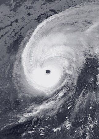
A tropical cyclone is a rapidly rotating storm system with a low-pressure center, a closed low-level atmospheric circulation, strong winds, and a spiral arrangement of thunderstorms that produce heavy rain and squalls. Depending on its location and strength, a tropical cyclone is called a hurricane, typhoon, tropical storm, cyclonic storm, tropical depression, or simply cyclone. A hurricane is a strong tropical cyclone that occurs in the Atlantic Ocean or northeastern Pacific Ocean, and a typhoon occurs in the northwestern Pacific Ocean. In the Indian Ocean and South Pacific, comparable storms are referred to as "tropical cyclones". In modern times, on average around 80 to 90 named tropical cyclones form each year around the world, over half of which develop hurricane-force winds of 65 kn or more. Tropical cyclones carry heat away from the tropics and transport it towards temperate latitudes. This plays an important role in regulating global climate. Tropical cyclones can be very harmful for people.
Explosive cyclogenesis is the rapid deepening of an extratropical cyclonic low-pressure area. The change in pressure needed to classify something as explosive cyclogenesis is latitude dependent. For example, at 60° latitude, explosive cyclogenesis occurs if the central pressure decreases by 24 millibars (0.71 inHg) or more in 24 hours. This is a predominantly maritime, winter event, but also occurs in continental settings. This process is the extratropical equivalent of the tropical rapid deepening. Although their cyclogenesis is entirely different from that of tropical cyclones, bomb cyclones can produce winds of 74 to 95 mph, the same order as the first categories of the Saffir–Simpson scale, and yield heavy precipitation. Even though only a minority of bomb cyclones become this strong, some weaker ones can also cause significant damage.

Severe weather is any dangerous meteorological phenomenon with the potential to cause damage, serious social disruption, or loss of human life. Types of severe weather phenomena vary, depending on the latitude, altitude, topography, and atmospheric conditions. High winds, hail, excessive precipitation, and wildfires are forms and effects of severe weather, as are thunderstorms, downbursts, tornadoes, waterspouts, tropical cyclones, and extratropical cyclones. Regional and seasonal severe weather phenomena include blizzards (snowstorms), ice storms, and duststorms.
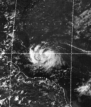
Tropical Storm Alma, the first named storm to develop in the 1974 Atlantic hurricane season, was a short lived tropical cyclone that made a rare Venezuelan landfall. The storm formed from the Intertropical Convergence Zone (ITCZ) on August 12 well to the east of the Windward Islands, but advisories were not issued until the next day when Alma was at peak intensity. Alma entered the southeastern Caribbean Sea at an unusually brisk westward pace of between 20 mph (32 km/h) to 25 mph (40 km/h), prompting numerous watches and gale warnings throughout the nations in this region. After crossing Trinidad, Alma became one of only four tropical storms to traverse the Paria Peninsula of northeastern Venezuela. The storm dissipated on August 15 over the high terrain of Venezuela.
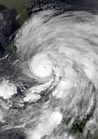
Hurricane Sandy was an extremely large and destructive Category 3 Atlantic hurricane which ravaged the Caribbean and the coastal Mid-Atlantic region of the United States in late October 2012. It was the largest Atlantic hurricane on record as measured by diameter, with tropical-storm-force winds spanning 1,150 miles (1,850 km). The storm inflicted nearly $70 billion USD in damage, and killed 233 people in eight countries, from the Caribbean to Canada. The eighteenth named storm, tenth hurricane, and second major hurricane of the 2012 Atlantic hurricane season, Sandy was a Category 3 storm at its peak intensity when it made landfall in Cuba, though most of the damage it caused was after it became a Category 1-equivalent extratropical cyclone off the coast of the Northeastern United States.
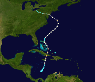
Hurricane Sandy was the sixth-costliest Atlantic hurricane on record. It lasted for over a week in late October-early November 2012. Classified as the eighteenth named storm, tenth hurricane, and second major hurricane of the annual hurricane season, Sandy originated from a tropical wave on October 22. Performing a small loop over the central Caribbean Sea, the system intensified into a tropical storm a day later and became the final hurricane of the season before briefly coming ashore the coast of Jamaica on October 24. After emerging between Jamaica and Cuba, Sandy began a period of rapid intensification into a Category 3 hurricane on the Saffir–Simpson hurricane wind scale, with maximum sustained winds of 115 mph (185 km/h). It made landfall at this intensity near Santiago de Cuba on October 25.
Hurricane Nicole was the first major hurricane to directly impact Bermuda since Hurricane Fabian in 2003 and equally one of the strongest hurricanes to do so. The fourteenth named storm, sixth hurricane, and third major hurricane of the 2016 Atlantic hurricane season, Nicole formed in the central Atlantic on October 4. The small, slow-moving storm defied forecasts by steadily organizing despite strong wind shear, and it rapidly intensified to a Category 2 hurricane on October 7. The wind shear finally took its toll by October 8, reducing Nicole to a minimal tropical storm, as a building high pressure system forced the storm southward. Intensification began once again as the storm retreated toward Bermuda, and Nicole reached its peak intensity early on October 13 as a Category 4 hurricane with 140 mph (230 km/h) winds. Shortly thereafter, increased vertical wind shear weakened the storm to Category 3, and the eye passed over Bermuda later that day. Afterward, Nicole accelerated northeastwards while gradually weakening, but significantly expanding in size as it traversed the Northern Atlantic. By October 18, decreasing sea surface temperatures caused the large hurricane to become extratropical as it accelerated northwards toward Greenland.

Racer's hurricane was a destructive tropical cyclone that had severe effects in northeastern Mexico, the Republic of Texas, and the Gulf Coast of the United States in early October 1837. It was named after the Royal Navy ship HMS Racer, which encountered the cyclone in the northwestern Caribbean. Termed "one of the most famous and destructive hurricanes of the century" by meteorology historian David Ludlum, the storm first affected Jamaica with flooding rainfall and strong winds on September 26 and 27, before entering the Gulf of Mexico by October 1. As the hurricane struck northern Tamaulipas and southern Texas, it slowed to a crawl and turned sharply northeastward. The storm battered the Gulf Coast from Texas to the Florida Panhandle between October 3 and 7. After crossing the Southeastern United States, it emerged into the Atlantic shipping lanes off the Carolinas by October 9.

The March 2019 North American blizzard was a powerful Colorado Low that produced up to two feet of snow in the plains and Midwest. Rapid snowmelt following the storm caused historic flooding, and some areas received hurricane-force wind gusts. Comparable to the 1993 Storm of the Century, the storm was labeled a bomb cyclone after barometric pressure readings dropped in excess of 24 mbar (0.71 inHg) over a 24-hour period. After the storm entered Colorado from its origination in Arizona, the pressure dropped more than 30 mbar (0.89 inHg) and rapidly intensified over the western High Plains. The severe storm set new all-time record low barometric pressure readings in Colorado, Kansas and New Mexico. The storm itself killed only one person in Colorado, but flooding caused by the storm killed at least 3, one in Iowa and at least two in Nebraska and left ~140,000 without power in Texas.
