Westerlies

Last updated

The westerlies (blue) and trade winds (yellow and brown) Map prevailing winds on earth.png
The westerlies (blue) and trade winds (yellow and brown)
The general atmospheric circulation. Trade winds (red), westerlies (white) and the South Pacific anticyclone (blue) Vientos del oeste.jpg
The general atmospheric circulation. Trade winds (red), westerlies (white) and the South Pacific anticyclone (blue)

The westerlies, anti-trades, [2] or prevailing westerlies, are prevailing winds from the west toward the east in the middle latitudes between 30 and 60 degrees latitude. They originate from the high-pressure areas in the horse latitudes and trend towards the poles and steer extratropical cyclones in this general manner. [3] Tropical cyclones which cross the subtropical ridge axis into the westerlies recurve due to the increased westerly flow. The winds are predominantly from the southwest in the Northern Hemisphere and from the northwest in the Southern Hemisphere.

Contents

The westerlies are strongest in the winter hemisphere and times when the pressure is lower over the poles, while they are weakest in the summer hemisphere and when pressures are higher over the poles. The westerlies are particularly strong, especially in the Southern Hemisphere (called also 'Brave West winds' at striking Chile, Tasmania and New Zealand), in areas where land is absent, because land amplifies the flow pattern, making the current more north–south oriented, slowing the westerlies. The strongest westerly winds in the middle latitudes can come in the roaring forties, between 40 and 50 degrees south latitude. The westerlies play an important role in carrying the warm, equatorial waters and winds to the western coasts of continents, especially in the southern hemisphere because of its vast oceanic expanse.

Behaviour

If the Earth were tidally locked to the Sun, solar heating would cause winds across the mid-latitudes to blow in a poleward direction, away from the subtropical ridge. However, the Coriolis effect caused by the rotation of Earth tends to deflect poleward winds eastward from north (to the right) in the Northern Hemisphere and eastward from south (to the left) in the Southern Hemisphere. [4] This is why winds across the Northern Hemisphere tend to blow from the southwest, but they tend to be from the northwest in the Southern Hemisphere. [5] When pressures are lower over the poles, the strength of the westerlies increases, which has the effect of warming the mid-latitudes. This occurs when the Arctic oscillation is positive, and during winter low pressure near the poles is stronger than it would be during the summer. When it is negative and pressures are higher over the poles, the flow is more meridional, blowing from the direction of the pole towards the Equator, which brings cold air into the mid-latitudes. [6]

Throughout the year, the westerlies vary in strength with the polar cyclone. As the cyclone reaches its maximum intensity in winter, the westerlies increase in strength. As the cyclone reaches its weakest intensity in summer, the Westerlies weaken. [7] An example of the impact of the westerlies is when dust plumes, originating in the Gobi desert combine with pollutants and spread large distances downwind, or eastward, into North America. [8] The westerlies can be particularly strong, especially in the Southern Hemisphere, where there is less land in the middle to cause the progression of west to east winds to slow down. In the Southern hemisphere, because of the stormy and cloudy conditions, it is usual to refer to the westerlies as the roaring forties, furious fifties, or shrieking sixties according to the varying degrees of latitude. [9]

Impact on ocean currents

Benjamin Franklin's map of the Gulf Stream Franklingulfstream.jpg
Benjamin Franklin's map of the Gulf Stream

Due to persistent winds from west to east on the poleward sides of the subtropical ridges located in the Atlantic and Pacific oceans, ocean currents are driven in a similar manner in both hemispheres. The currents in the Northern Hemisphere are weaker than those in the Southern Hemisphere due to the differences in strength between the westerlies of each hemisphere. [10] The process of western intensification causes currents on the western boundary of an ocean basin to be stronger than those on the eastern boundary of an ocean. [11] These western ocean currents transport warm, tropical water polewards toward the polar regions. Ships crossing both oceans have taken advantage of the ocean currents for centuries.

The Antarctic Circumpolar Current (ACC), or the West Wind Drift, is an ocean current that flows from west to east around Antarctica. The ACC is the dominant circulation feature of the Southern Ocean and, at approximately 125 Sverdrups, the largest ocean current. [12] In the northern hemisphere, the Gulf Stream, part of the North Atlantic Subtropical Gyre, has led to the development of strong cyclones of all types at the base of the Westerlies, both within the atmosphere and within the ocean. [13] [14] [15] The Kuroshio (Japanese for "Black Tide") is a strong western boundary current in the western north Pacific Ocean, similar to the Gulf Stream, which has also contributed to the depth of ocean storms in that region.

Extratropical cyclones

A fictitious synoptic chart of an extratropical cyclone affecting the UK and Ireland. The blue arrows between isobars indicate the direction of the wind, while the "L" symbol denotes the centre of the "low". Note the occluded, cold and warm frontal boundaries. UK-Cyclone.gif
A fictitious synoptic chart of an extratropical cyclone affecting the UK and Ireland. The blue arrows between isobars indicate the direction of the wind, while the "L" symbol denotes the centre of the "low". Note the occluded, cold and warm frontal boundaries.

An extratropical cyclone is a synoptic scale low-pressure weather system that has neither tropical nor polar characteristics, being connected with fronts and horizontal gradients in temperature and dew point otherwise known as "baroclinic zones". [16]

The descriptor "extratropical" refers to the fact that this type of cyclone generally occurs outside of the tropics, in the middle latitudes of the planet, where the Westerlies steer the system generally from west to east. These systems may also be described as "mid-latitude cyclones" due to their area of formation, or "post-tropical cyclones" where extratropical transition has occurred, [16] [17] and are often described as "depressions" or "lows" by weather forecasters and the general public. These are the everyday phenomena which along with anticyclones, drive the weather over much of the Earth.

Although extratropical cyclones are almost always classified as baroclinic since they form along zones of temperature and dewpoint gradient, they can sometimes become barotropic late in their life cycle when the temperature distribution around the cyclone becomes fairly uniform along the radius from the center of low pressure. [18] An extratropical cyclone can transform into a subtropical storm, and from there into a tropical cyclone, if it dwells over warm waters and develops central convection, which warms its core and causes temperature and dewpoint gradients near their centers to fade. [19]

Interaction with tropical cyclones

Storm track of Hurricane Bill (2009), showing a classic recurvature off the American coast in 2009 Bill 2009 track.png
Storm track of Hurricane Bill (2009), showing a classic recurvature off the American coast in 2009

When a tropical cyclone crosses the subtropical ridge axis, normally through a break in the high-pressure area caused by a system traversing the Westerlies, its general track around the high-pressure area is deflected significantly by winds moving towards the general low-pressure area to its north. When the cyclone track becomes strongly poleward with an easterly component, the cyclone has begun recurvature, entering the Westerlies. [20] A typhoon moving through the Pacific Ocean towards Asia, for example, will recurve offshore of Japan to the north, and then to the northeast, if the typhoon encounters southwesterly winds (blowing northeastward) around a low-pressure system passing over China or Siberia. Many tropical cyclones are eventually forced toward the northeast by extratropical cyclones in this manner, which move from west to east to the north of the subtropical ridge. An example of a tropical cyclone in recurvature was Typhoon Ioke in 2006, which took a similar trajectory. [21]

See also

Related Research Articles

<span class="mw-page-title-main">Cyclone</span> Large scale air mass that rotates around a strong center of low pressure

In meteorology, a cyclone is a large air mass that rotates around a strong center of low atmospheric pressure, counterclockwise in the Northern Hemisphere and clockwise in the Southern Hemisphere as viewed from above. Cyclones are characterized by inward-spiraling winds that rotate about a zone of low pressure. The largest low-pressure systems are polar vortices and extratropical cyclones of the largest scale. Warm-core cyclones such as tropical cyclones and subtropical cyclones also lie within the synoptic scale. Mesocyclones, tornadoes, and dust devils lie within the smaller mesoscale.

<span class="mw-page-title-main">Horse latitudes</span> Latitudes 30–35 degrees north and south of the Equator

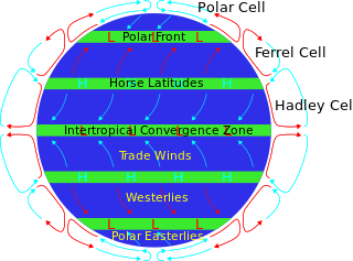
The horse latitudes are the latitudes about 30 degrees north and south of the Equator. They are characterized by sunny skies, calm winds, and very little precipitation. They are also known as subtropical ridges or highs. It is a high-pressure area at the divergence of trade winds and the westerlies.

<span class="mw-page-title-main">Subtropical cyclone</span> Cyclonic storm with both tropical and extratropical characteristics

A subtropical cyclone is a weather system that has some characteristics of both tropical and extratropical cyclones.

<span class="mw-page-title-main">Physical oceanography</span> Study of physical conditions and processes within the ocean

Physical oceanography is the study of physical conditions and physical processes within the ocean, especially the motions and physical properties of ocean waters.

<span class="mw-page-title-main">Atmospheric circulation</span> Process which distributes thermal energy about the Earths surface

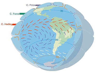
Atmospheric circulation is the large-scale movement of air and together with ocean circulation is the means by which thermal energy is redistributed on the surface of the Earth. The Earth's atmospheric circulation varies from year to year, but the large-scale structure of its circulation remains fairly constant. The smaller-scale weather systems – mid-latitude depressions, or tropical convective cells – occur chaotically, and long-range weather predictions of those cannot be made beyond ten days in practice, or a month in theory.

<span class="mw-page-title-main">High-pressure area</span> Region with higher atmospheric pressure

A high-pressure area, high, or anticyclone, is an area near the surface of a planet where the atmospheric pressure is greater than the pressure in the surrounding regions. Highs are middle-scale meteorological features that result from interplays between the relatively larger-scale dynamics of an entire planet's atmospheric circulation.

<span class="mw-page-title-main">Low-pressure area</span> Area with air pressures lower than adjacent areas

In meteorology, a low-pressure area, low area or low is a region where the atmospheric pressure is lower than that of surrounding locations. Low-pressure areas are commonly associated with inclement weather, while high-pressure areas are associated with lighter winds and clear skies. Winds circle anti-clockwise around lows in the northern hemisphere, and clockwise in the southern hemisphere, due to opposing Coriolis forces. Low-pressure systems form under areas of wind divergence that occur in the upper levels of the atmosphere (aloft). The formation process of a low-pressure area is known as cyclogenesis. In meteorology, atmospheric divergence aloft occurs in two kinds of places:

<span class="mw-page-title-main">Synoptic scale meteorology</span> 1000-km-order method of measuring weather systems

In meteorology, the synoptic scale is a horizontal length scale of the order of 1,000 km (620 mi) or more. This corresponds to a horizontal scale typical of mid-latitude depressions. Most high- and low-pressure areas seen on weather maps are synoptic-scale systems, driven by the location of Rossby waves in their respective hemisphere. Low-pressure areas and their related frontal zones occur on the leading edge of a trough within the Rossby wave pattern, while high-pressure areas form on the back edge of the trough. Most precipitation areas occur near frontal zones. The word synoptic is derived from the Ancient Greek word συνοπτικός (sunoptikós), meaning "seen together".

<span class="mw-page-title-main">Trade winds</span> Equatorial east-to-west prevailing winds

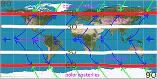
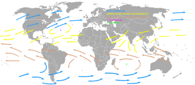
The trade winds or easterlies are permanent east-to-west prevailing winds that flow in the Earth's equatorial region. The trade winds blow mainly from the northeast in the Northern Hemisphere and from the southeast in the Southern Hemisphere, strengthening during the winter and when the Arctic oscillation is in its warm phase. Trade winds have been used by captains of sailing ships to cross the world's oceans for centuries. They enabled European colonization of the Americas, and trade routes to become established across the Atlantic Ocean and the Pacific Ocean.

<span class="mw-page-title-main">Prevailing winds</span> Strongest direction of wind on a region of Earths surface

In meteorology, prevailing wind in a region of the Earth's surface is a surface wind that blows predominantly from a particular direction. The dominant winds are the trends in direction of wind with the highest speed over a particular point on the Earth's surface at any given time. A region's prevailing and dominant winds are the result of global patterns of movement in the Earth's atmosphere. In general, winds are predominantly easterly at low latitudes globally. In the mid-latitudes, westerly winds are dominant, and their strength is largely determined by the polar cyclone. In areas where winds tend to be light, the sea breeze/land breeze cycle is the most important cause of the prevailing wind; in areas which have variable terrain, mountain and valley breezes dominate the wind pattern. Highly elevated surfaces can induce a thermal low, which then augments the environmental wind flow.

<span class="mw-page-title-main">1986 Pacific typhoon season</span> Typhoon season in the Pacific Ocean

The 1986 Pacific typhoon season has no official bounds; it ran year-round in 1986, but most tropical cyclones tend to form in the northwestern Pacific Ocean between May and December. These dates conventionally delimit the period of each year when most tropical cyclones form in the northwestern Pacific Ocean. Tropical Storms formed in the entire west pacific basin were assigned a name by the Joint Typhoon Warning Center. Tropical depressions that enter or form in the Philippine area of responsibility are assigned a name by the Philippine Atmospheric, Geophysical and Astronomical Services Administration or PAGASA. This can often result in the same storm having two names.

<span class="mw-page-title-main">1981 Pacific typhoon season</span> Period of formation of tropical cyclones in the Western Pacific Ocean in 1981

The 1981 Pacific typhoon season was a slightly above average season that produced 29 tropical storms, 13 typhoons and two intense typhoons. The season ran throughout 1981, though most tropical cyclones typically develop between May and October. The season's first named storm, Freda, developed on March 12 while the final storm, Lee, dissipated on December 29. Tropical cyclones only accounted for 12 percent of the rainfall in Hong Kong this season, the lowest percentage for the protectorate since 1972.

<span class="mw-page-title-main">Atlantic hurricane</span> Tropical cyclone that forms in the Atlantic Ocean

An Atlantic hurricane is a type of tropical cyclone that forms in the Atlantic Ocean primarily between June and November. The terms "hurricane", "typhoon", and "cyclone" can be used interchangeably to describe this weather phenomenon. These storms are rotating, organized systems of clouds and thunderstorms that originate over tropical or subtropical waters and have closed low-level circulation, not to be confused with tornadoes. They form over low pressure systems. In the North Atlantic, central North Pacific, and eastern North Pacific, the term "hurricane" is mainly used, whereas "typhoon" is more commonly used for storms originating in the western North Pacific. The term "cyclone" is used in the South Pacific and Indian Ocean.

<span class="mw-page-title-main">Monsoon trough</span> Weather phenomenon

The monsoon trough is a portion of the Intertropical Convergence Zone in the Western Pacific, as depicted by a line on a weather map showing the locations of minimum sea level pressure, and as such, is a convergence zone between the wind patterns of the southern and northern hemispheres.

<span class="mw-page-title-main">Tropical cyclogenesis</span> Development and strengthening of a tropical cyclone in the atmosphere

Tropical cyclogenesis is the development and strengthening of a tropical cyclone in the atmosphere. The mechanisms through which tropical cyclogenesis occurs are distinctly different from those through which temperate cyclogenesis occurs. Tropical cyclogenesis involves the development of a warm-core cyclone, due to significant convection in a favorable atmospheric environment.

<span class="mw-page-title-main">Extratropical cyclone</span> Type of cyclone

Extratropical cyclones, sometimes called mid-latitude cyclones or wave cyclones, are low-pressure areas which, along with the anticyclones of high-pressure areas, drive the weather over much of the Earth. Extratropical cyclones are capable of producing anything from cloudiness and mild showers to severe gales, thunderstorms, blizzards, and tornadoes. These types of cyclones are defined as large scale (synoptic) low pressure weather systems that occur in the middle latitudes of the Earth. In contrast with tropical cyclones, extratropical cyclones produce rapid changes in temperature and dew point along broad lines, called weather fronts, about the center of the cyclone.

<span class="mw-page-title-main">Tropical cyclone</span> Rapidly rotating storm system

A tropical cyclone is a rapidly rotating storm system characterized by a low-pressure center, a closed low-level atmospheric circulation, strong winds, and a spiral arrangement of thunderstorms that produce heavy rain and squalls. Depending on its location and strength, a tropical cyclone is referred to by different names, including hurricane, typhoon, tropical storm, cyclonic storm, tropical depression, or simply cyclone. A hurricane is a strong tropical cyclone that occurs in the Atlantic Ocean or northeastern Pacific Ocean, and a typhoon occurs in the northwestern Pacific Ocean. In the Indian Ocean and South Pacific, comparable storms are referred to as "tropical cyclones". In modern times, on average around 80 to 90 named tropical cyclones form each year around the world, over half of which develop hurricane-force winds of 65 kn or more. Tropical cyclones carry heat and energy away from the tropics and transport it towards temperate latitudes, which plays an important role in regulating global climate.

<span class="mw-page-title-main">Upper tropospheric cyclonic vortex</span>

An upper tropospheric cyclonic vortex is a vortex, or a circulation with a definable center, that usually moves slowly from east-northeast to west-southwest and is prevalent across Northern Hemisphere's warm season. Its circulations generally do not extend below 6,080 metres (19,950 ft) in altitude, as it is an example of a cold-core low. A weak inverted wave in the easterlies is generally found beneath it, and it may also be associated with broad areas of high-level clouds. Downward development results in an increase of cumulus clouds and the appearance of circulation at ground level. In rare cases, a warm-core cyclone can develop in its associated convective activity, resulting in a tropical cyclone and a weakening and southwest movement of the nearby upper tropospheric cyclonic vortex. Symbiotic relationships can exist between tropical cyclones and the upper level lows in their wake, with the two systems occasionally leading to their mutual strengthening. When they move over land during the warm season, an increase in monsoon rains occurs.

<span class="mw-page-title-main">Cold-core low</span> Cyclone with an associated cold pool of air at high altitude

A cold-core low, also known as an upper level low or cold-core cyclone, is a cyclone aloft which has an associated cold pool of air residing at high altitude within the Earth's troposphere, without a frontal structure. It is a low pressure system that strengthens with height in accordance with the thermal wind relationship. If a weak surface circulation forms in response to such a feature at subtropical latitudes of the eastern north Pacific or north Indian oceans, it is called a subtropical cyclone. Cloud cover and rainfall mainly occurs with these systems during the day.

<span class="mw-page-title-main">Typhoon Songda (2016)</span> Pacific typhoon in 2016

Typhoon Songda was the sixth most intense tropical cyclone of the Northwest Pacific Ocean in 2016. Also known as the Ides of October storm, it struck the Pacific Northwest region of the United States and Canada as a powerful extratropical cyclone. Songda was the twentieth named storm and the ninth typhoon of the annual typhoon season. The system developed into a tropical storm south of Minamitorishima on October 8 and strengthened into a typhoon on October 10. Songda reached its peak intensity southeast of Japan late on October 11 at an unusually high latitude, before it became extratropical on October 13.

References

  1. Martín, Rodrigo Sebastian (2019-04-28). LA PEQUEÑA EDAD DE HIELO EN PATAGONIA AUSTRAL, estudio de la evolución histórica de las comunidades de quironómidos (Diptera, Chironomidae) en la Laguna Azul, Santa Cruz, Argentina [The Little Ice Age in Southern Patagonia: A Study of the Historical Evolution of Chironomid Communities (Diptera, Chironomidae) in Laguna Azul, Santa Cruz, Argentina.](PDF) (in Spanish). UBA (published 2022).
  2. Robert Fitzroy (1863). The weather book: a manual of practical meteorology. Longman, Green, Longman, Roberts, & Green. p.  63.
  3. "Westerlies". Glossary of Meteorology. American Meteorological Society. 2005. Archived from the original on 2010-06-22. Retrieved 2018-01-22.
  4. Nathan Gasser (2000-08-10). Solar Heating and Coriolis Forces. University of Tennessee at Knoxville. Retrieved on 2009-05-31.
  5. Ralph Stockman Tarr and Frank Morton McMurry (1909). Advanced geography. W. W. Shannon, State Printing, pp. 246. Retrieved on 2009-04-15.
  6. National Snow and Ice Data Center (2009). The Arctic Oscillation. Arctic Climatology and Meteorology. Retrieved on 2009-04-11.
  7. Halldór Björnsson (2005). Global circulation. Archived 2011-08-07 at the Wayback Machine Veðurstofu Íslands. Retrieved on 2008-06-15.
  8. Bishop, James K. B.; Davis, Russ E.; Sherman, Jeffrey T. (2002). "Robotic Observations of Dust Storm Enhancement of Carbon Biomass in the North Pacific". Science. 298 (5594): 817–821. Bibcode:2002Sci...298..817B. doi:10.1126/science.1074961. PMID   12399588. S2CID   38762011.
  9. Walker, Stuart (1998). The sailor's wind . W. W. Norton & Company. pp.  91. ISBN   9780393045550. Roaring Forties Shrieking Sixties westerlies.
  10. Wunsch, Carl (November 8, 2002). "What Is the Thermohaline Circulation?". Science. 298 (5596): 1179–1181. doi:10.1126/science.1079329. PMID   12424356. S2CID   129518576. (see also Rahmstorf.)
  11. National Environmental Satellite, Data, and Information Service (2009). Investigating the Gulf Stream. Archived 2010-05-03 at the Wayback Machine North Carolina State University. Retrieved on 2009-05-06.
  12. Ryan Smith, Melicie Desflots, Sean White, Arthur J. Mariano, Edward H. Ryan (2005). The Antarctic CP Current. The Cooperative Institute for Marine and Atmospheric Studies. Retrieved on 2009-04-11.
  13. Businger, S.; Graziano, T. M.; Kaplan, M. L.; Rozumalski, R. A. (2005). "Cold-air cyclogenesis along the Gulf-Stream front: Investigation of diabatic impacts on cyclone development, frontal structure, and track". Meteorology and Atmospheric Physics. 88 (1–2): 65–90. Bibcode:2005MAP....88...65B. doi:10.1007/s00703-003-0050-y. S2CID   120130551.
  14. David M. Roth (2000). A FIFTY YEAR HISTORY OF SUBTROPICAL CYCLONES. American Meteorological Society. Retrieved on 2008-09-21.
  15. Savidge, Dana K.; Bane, John M. (1999). "Cyclogenesis in the deep ocean beneath the Gulf Stream: 1. Description". Journal of Geophysical Research: Oceans. 104 (C8): 18111–18126. Bibcode:1999JGR...10418111S. doi:10.1029/1999JC900132.
  16. 1 2 DeCaria (2007-05-29). "ESCI 241 – Meteorology; Lesson 16 – Extratropical Cyclones". Department of Earth Sciences, Millersville University, Millersville, Pennsylvania. Archived from the original on 2007-05-29. Retrieved 2009-05-31.
  17. Robert Hart & Jenni Evans (2003). "Synoptic Composites of the Extratropical Transition Lifecycle of North Atlantic TCs as Defined Within Cyclone Phase Space" (PDF). ams.confex.com. Retrieved 2006-10-03.
  18. Ryan N. Maue (2009). CHAPTER 3: CYCLONE PARADIGMS AND EXTRATROPICAL TRANSITION CONCEPTUALIZATIONS. Archived 2008-05-10 at the Wayback Machine Florida State University. Retrieved on 2008-06-15.
  19. Atlantic Oceanographic and Meteorological Laboratory; Hurricane Research Division (2004). "Frequently Asked Questions: What is an extra-tropical cyclone?". NOAA . Retrieved 2006-07-25.
  20. Joint Typhoon Warning Center (2009). Section 2: Tropical Cyclone Motion Terminology. United States Navy. Retrieved on 2007-04-10.
  21. Powell, Jeff; et al. (May 2007). "Hurricane Ioke: 20–27 August 2006". 2006 Tropical Cyclones Central North Pacific. Central Pacific Hurricane Center . Retrieved 2007-06-09.