Kition 𐤊𐤕 or 𐤊𐤕𐤉 Κίτιον | |
---|---|
12th century BC–342 AD [1] | |
Capital | Kition |
Common languages | Greek [2] and Phoenician [2] |
Religion | Ancient Greek religion/Ancient Canaanite religion |
Government | Petty kingdom |
Historical era | Classical Antiquity |
• Established | 12th century BC |
• Disestablished | 342 AD [1] |
Currency | Stater, obol |
Today part of | Cyprus |
kꜣṯꜣj [3] in hieroglyphs | ||||||
---|---|---|---|---|---|---|
Era: New Kingdom (1550–1069 BC) | ||||||
Kition (Ancient Greek: Κίτιον, Kition; Latin: Citium; [4] Egyptian: kꜣṯꜣj; [3] Phoenician: 𐤊𐤕, KT, [5] [6] or 𐤊𐤕𐤉, KTY; [7] [8] [9] ) was an Ancient Greek city-kingdom on the southern coast of Cyprus (in present-day Larnaca), one of the Ten city-kingdoms of Cyprus. According to the text on the plaque closest to the excavation pit of the Kathari site (as of 2013), it was established in the 13th century BC by Greek (Achaean) settlers, after the Trojan War.
Its most famous, and probably only known, resident was Zeno of Citium, born c. 334 BC in Citium and founder of the Stoic school of philosophy which he taught in Athens from about 300 BC.
Citium (Citium) is the Latinised form of the Ancient Greek name Kítion (Κίτιον). [10] The names originated from the Phoenician name 𐤊𐤕𐤉 (KTY, pronounced Kitiya). [9]
The city-kingdom was originally established in the 12th century BC by Greek (Achaean) settlers, after the Trojan war. [11]
Mycenaeans first settled in the area for the purpose of the exploitation of copper, but the settlement eventually faded two centuries later as a result of constant disarray and anxiety of the time. [12]
New cultural elements appearing between 1200 BC and 1000 BC (personal objects, pottery, new architectural forms and ideas) are indications of significant political changes after the arrival of the Achaeans, the first Greek colonists of Kition. [13]
Early in the 12th century BC the town was rebuilt on a larger scale; its mudbrick city wall was replaced by a cyclopean wall. [14] Around 1000 BC, the religious part of the city was abandoned, although life seems to have continued in other areas as indicated by finds in tombs. [15]
Literary evidence suggests an early Phoenician presence also at Kition which was under Tyrian rule at the beginning of the 10th century BC. [16] Some Phoenician merchants who were believed to come from Tyre colonized the area and expanded the political influence of Kition. After c. 850 BC the sanctuaries [at the Kathari site] were rebuilt and reused by the Phoenicians." [13]
The kingdom was under Egyptian domination from 570 to 545 BC. [17] Persia ruled Cyprus from 545 BC. [17] Kings of the city are referred to by name from 500 BC—in Phoenician texts and as inscriptions on coins. [18]
Marguerite Yon claims that literary texts and inscriptions suggest that by the Classical period Kition was one of the principal local powers, along with its neighbour Salamis. [18] In 499 BC Cypriot kingdoms (including Kition) joined Ionia's revolt against Persia. [19]
Persian rule of Cyprus ended in 332 BC.
Ptolemy I conquered Cyprus in 312 BC and killed Poumyathon, the Phoenician king of Kition, and burned the temples. [17] Shortly afterwards the Cypriot city-kingdoms were dissolved and the Phoenician dynasty of Kition was abolished. Following these events the area lost its religious character. [20]
However, a trading colony from Kition established at Piraeus had prospered to the point that, in 233 BC they requested and received permission for the construction of a temple dedicated to Astarte". [21]
Cyprus was annexed by Rome in 58 BC. [22]
Strong [1] earthquakes hit the city in 76 AD and the year after, but the city seems to have been prosperous during Roman times. A curator civitatis, or financial administrator of the city, was sent to Kition from Rome during the rule of Septimius Severus. [22]
Earthquakes of 322 and 342 AD "caused the destruction not only of Kition but also of Salamis and Pafos". [1]
Kition was first systematically [23] excavated by the Swedish Cyprus Archaeological Expedition from October 1929 (under the direction of Einar Gjerstad) until April 1930.
The ruins can be found within the borders of the modern town of Larnaca. The ancient city was surrounded by massive walls which can still be traced today. At the Bamboula hill, in the northeastern part of the city, was the acropolis. Here, the Swedish archaeologists discovered a sanctuary dedicated to Heracles-Melqart. Between the acropolis and the modern seashore was the ancient harbour. In 1879 the Government of Cyprus filled this marshy area with soil from the upper strata of the Bamboula Hill because they wished to get rid of the malaria mosquitos. Because of this the Bamboula Hill and especially the upper layers of the acropolis were much disturbed. A small part of the city was excavated as early as 1894 by british archeologists. [24]
The Swedish archaeologists attempted a stratigraphic examination of the Bamboula mound to obtain information about the dating of the Phoenician colonization of Cyprus. They wanted to study the ceramic development and collect archaeological material to elucidate how the Phoenicians affected the development of the Cypriote culture. But, after three days of digging, they found a large deposit of sculptures and needed to subsequently enlarge the excavation. [24]
According to The Swedish Cyprus Expedition, the acropolis commenced as a settlement from the end of the Late Cypriote II and the beginning of Cypro Geometric I period before it became a sanctuary. Throughout the time of the Cypro-Archaic I something changed, and Kition began to be used as an open-air sanctuary. The Swedish Expedition did not find any votive sculptures from this early stage, therefore the votives might have been of a different kind or removed to a place outside the excavation. They did find a rectangular base of a statue called no. 560. The statue itself was missing with only the feet preserved. This sculpture was probably very big and could have been Kition’s cult statue. Later, the cult erected a rectangular altar made of rubble and chips of stone in front of the statue. [24]
The temenos were in use until the end of the Cypro-Archaic II period when a new temenos was built on top of the old one. This temenos was enclosed by a massive peribolos wall. Furthermore, it seems like an inner temenos was created at the same place as the earlier walls had been. Within the inner temenos a low altar consisting of a square was found, as well as another pillar altar outside. Both on the altar itself and close to it the archaeologists found remains of ash and carbonized matter. All through the periods votive gifts, mainly consisting of sculptures, were placed in the sanctuary, and each time the level was raised the sculptures were transferred to the new sanctuary. Throughout the Cypro-Classic I period, the temenos were rearranged entirely and became more monumental. This sanctuary was the last one before the sanctuary was demolished in the Hellenistic period and secular buildings were erected in the same place. During the demolition, all the votive sculptures were buried, and the place was no longer used for sacred purposes. The Hellenistic house was divided into two parts and inside archaeologists found remains of a basalt press for pressing wine or oil, as well as rectangular drainage outlets and a storage vessel. [24]
During the excavation, they found no inscriptions that could inform us to whom this sanctuary was dedicated, although some of the sculptures might represent the god and thence give us an answer. Most of the sculptures dressed in lion’s skin and a club in the right hand, are a Cypriot variety of the Greek Heracles, which the Phoenicians identified with their god Melqart, the patron god of Kition. Therefore, the archaeologists concluded that the sanctuary was dedicated to the city god of Kition, Heracles-Melqart. [25]
Einar Gjerstad explains the reason why the temenos were never rebuilt as a consequence of the last king of Kition, Pumiatihon. Pumiatihon sided with Antigonus in the struggle between him and Ptolemy I Soter. He lost his life and throne which meant that Kition ceased to be an independent state after Ptolemy’s conquest of Kition in 312 B.C. and since the temple was the religious sign of the political independence of Kition it couldn't be rebuilt after the conquest. [24]
Archaeology is continuing near the Kathari site. A magnificent 20m-long Roman mosaic showing the labours of Hercules was discovered in a baths building in 2016. [26] It was found under Kyriakou Matsi Street when clearing a sewer and is expected to be transferred to the museum. [27]
This site is located around 500 metres north of the Bamboula site and sometimes referred to as "Kition Area II". [11] The Department of Antiquities (under the direction of Vassos Karageorghis) started excavating in 1959 [28] continuing until 1981. [29]
Excavations have revealed part of a defensive wall, dating from the 13th century BC [30] and remains of five temples including cyclopean walls. The largest temple's (horizontal) dimensions were 35 m by 22 m. [31] and was built using ashlar blocks. Temple (2) was rebuilt—around 1200 BC. [17] Temple (1) has Late Bronze Age graffiti of ships on the façade of the south wall. [17]
The site is located around 50 metres north of the Larnaca Museum. In 1845 the Sargon Stele was found here, together with a gilded silver plakette now in the Louvre.
A British Expedition first excavated the site in 1913.
A French team from the University of Lyon [23] started excavating in 1976. [32] [33] when traces of settlement dating to the tenth century BC were found along ramparts next to the port at Bamboula. [18] The site also consists of a sanctuary of Astarte and a sanctuary of Melkart. [23] The earliest sanctuary was built in the 9th century BC. [34]
1987 [35] saw the discovery of the Phoenician harbour for warships built in the 5th century BC. In its final stage, it consisted of ship sheds (six of them have been recorded), 6 metres wide and about 38 to 39 meters long, with shipways on which triremes were pulled up to dry under tiled roofs [34]
Five built tombs, or hypogea, have been discovered at Kition: the Vangelis Tomb, Godham's Tomb, the Phaneromeni, and the Turabi Tekke Tomb. [36] Two important stele with inscriptions in the Phoenician script were found in the Turabi Tekke cemetery in the late nineteenth century. They are now in the British Museum's collection. [37]
Kition Area I, "close to the west [city] wall of the Pre-Phoenician period, seems to have been a residential area" according to architectural and moveable finds. [22] "Kition Area III" and "-IV" are names of other archaeological sites at Kition. [11]
The "mound gate" in the city wall was located in the vicinity northwest of the Phaneromeni Tomb. [38]
There was also an acropolis. [39]
Sophocles Hadjisavvas has said that "the necropolis of Kition is the most extensively investigated burial ground on the island of Cyprus." [40] "The necropolis [of Kition] extends from the Ayios Prodromos and the area of Agios Ioannis "Pervolia" [41] and "Mnemata" (Northern Necropolis) to Ayios Georghios Kontos and the Chrysosotiros church (Soteros quarter), (Western Necropolis)." [36] A "part of the Kition necropolis became the subject of rescue work at the site of Agios Prodromos." [40]
One sports club uses the name Kition - AEK Kition.
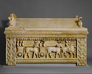
Amathus or Amathous was an ancient city and one of the ancient royal cities of Cyprus until about 300 BC. Some of its remains can be seen today on the southern coast in front of Agios Tychonas, about 24 miles (39 km) west of Larnaca and 6 miles (9.7 km) east of Limassol. Its ancient cult sanctuary of Aphrodite was the second most important in Cyprus, her homeland, after Paphos.
Human habitation of Cyprus dates back to the Paleolithic era. Cyprus's geographic position has caused Cyprus to be influenced by differing Eastern Mediterranean civilisations over the millennia.
Salamis was an ancient Greek city-state on the east coast of Cyprus, at the mouth of the river Pedieos, 6 km north of modern Famagusta. According to tradition, the founder of Salamis was Teucer, son of Telamon, king of the Greek island of Salamis, who could not return home after the Trojan War because he had failed to avenge his brother Ajax.
Soli or Soloi is an ancient Greek city on the island of Cyprus, located next to the town of Karavostasi, southwest of Morphou (Guzelyurt), and on the coast in the gulf of Morphou. Since 1974 the site has been within the territory of the Turkish Republic of Northern Cyprus.
Larnaca is a city on the south east coast of Cyprus and the capital of the district of the same name. It is the third-largest city in the country, after Nicosia and Limassol, with a metro population of 144,200 in 2015.
The ancient history of Cyprus shows a precocious sophistication in the Neolithic era visible in settlements such as at Choirokoitia dating from the 9th millennium BC, and at Kalavassos from about 7500 BC.
Idalion or Idalium was an ancient city in Cyprus, in modern Dali, Nicosia District. The city was founded on the copper trade in the 3rd millennium BC. Its name does not appear, however, on the renowned "Kition Stele", i.e., the Sargon Stele of 707 BC, but a little later on the Prism of Esarhaddon known as Niniveh A wherein the name is prefixed by the modifier URU (city) as URU.e-di-ʾi-il and in similar spellings in Ashurbanipal's annal while modified by KUR (land/kingdom).
Kourion was an important ancient Greek city-state on the southwestern coast of Cyprus. In the twelfth century BCE, after the collapse of the Mycenaean palaces, Greek settlers from Argos arrived on this site.
The Cypro-Minoan syllabary (CM), more commonly called the Cypro-Minoan Script, is an undeciphered syllabary used on the island of Cyprus and at its trading partners during the late Bronze Age and early Iron Age. The term "Cypro-Minoan" was coined by Arthur Evans in 1909 based on its visual similarity to Linear A on Minoan Crete, from which CM is thought to be derived. Approximately 250 objects—such as clay balls, cylinders, and tablets which bear Cypro-Minoan inscriptions, have been found. Discoveries have been made at various sites around Cyprus, as well as in the ancient city of Ugarit on the Syrian coast. It is thought to be somehow related to the later Cypriot syllabary.
The Swedish Cyprus Expedition was assembled to systematically investigate Cyprus’s early archaeological history. The expedition occurred between September 1927 and March 1931 and was led by the three archaeologists Einar Gjerstad, Erik Sjöqvist and Alfred Westholm together with the architect John Lindros who photographed during their time in Cyprus. The excavation constitutes the foundation of modern archaeology in Cyprus. The results of the excavations revealed that the distinctive culture of early Cyprus had been created in close contact with various cultures from the Middle East and the western Mediterranean areas.
Agia Eirini or Agia Irini is a village located on Morphou Bay, approximately 10 km north of Morphou. The village is located within Kyrenia District. It is under the de facto control of Northern Cyprus.
Roman Cyprus was a small senatorial province within the Roman Empire. While it was a small province, it possessed several well known religious sanctuaries and figured prominently in Eastern Mediterranean trade, particularly the production and trade of Cypriot copper. The island of Cyprus was situated at a strategically important position along Eastern Mediterranean trade routes, and had been controlled by various imperial powers throughout the first millennium BC. including: the Assyrians, Egyptians, Persians, Macedonians, and eventually the Romans. Cyprus was annexed by the Romans in 58 BC, but turbulence and civil war in Roman politics did not establish firm rule in Cyprus until 31 BC when Roman political struggles ended by Battle of Actium, and after about a decade, Cyprus was assigned a status of senatorial province in 22 BC. From then until the 7th century AD, Cyprus was controlled by the Romans. Cyprus officially became part of the Eastern Roman Empire in 293 AD.
Larnaca District Museum is a museum in Larnaca, Cyprus that has displays that show the "historical development of the city of Kition and the District of Larnaka in general." It was inaugurated in 1969. and was formerly named Larnaca District Archaeological Museum. It is controlled by the Department of Antiquities.
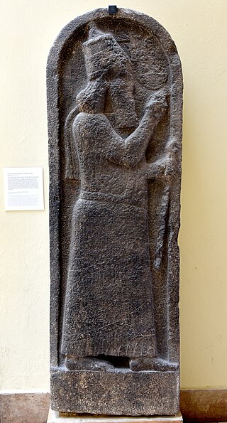
The Sargon Stele was found in the autumn of 1845 in Cyprus on the site of the former city-kingdom of Kition, in present-day Larnaca to the west of the old harbour of Kition on the archaeological site of Bamboula. The language on the stele is Assyrian Akkadian.
The Mnemata Site is an archaeological excavation site at the Mnemata locality of Larnaca, Cyprus. A tomb was discovered in 1979—during the construction of a refugee settlement.
The pottery of ancient Cyprus starts during the Neolithic period. Throughout the ages, Cypriot ceramics demonstrate many connections with cultures from around the Mediterranean. During the Early and Middle Bronze Ages, it is especially imaginative in shape and decoration. There are also many early terracotta figurines that were produced depicting female figures.
The Kition Necropolis Phoenician inscriptions are four Phoenician inscriptions discovered in the necropolis of Tourapi at Kition in 1894 by British archaeologist John Myres on behalf of the Cyprus Exploration Fund.
Mersinaki is an ancient place located near the shore, between Vouni and Soli, in Cyprus. The Swedish Cyprus Expedition, led by Einar Gjerstad, excavated Mersinaki during the year 1930 and found an open-air sanctuary by a river delta.
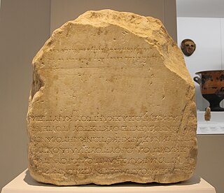
Pumayyaton and Pnytarion's inscriptions are two separated inscriptions, Phoenician and Greek, engraved on the same marble base which was found in Gdhi or Gai locality near Dromolaxia. About 3 hundred years after the first inscription, the Phoenician, was engraved, the base was turned upside down and the second inscription, in Greek, was engraved; the inscriptions have no connection and are not a bilingual inscription. Eventualy, it was used as a press. It is now exhibited in Larnaca District Archaeological Museum.
Marguerite Yon, or Marguerite Yon-Calvet, is a French archaeologist and Assyriologist specializing in the ancient Near East, particularly Ugarit in Syria. She is widely recognized for her archaeological work on Ugarit, where she conducted excavations for twenty years. Additionally, she has extensively excavated the island of Cyprus. Notably, she held the distinction of being the first female president of the Academy of Lyon since 1701.
{{cite book}}
: CS1 maint: date and year (link){{cite book}}
: CS1 maint: date and year (link)