La Center, Washington

Last updated

La Center
Clark County Washington Incorporated and Unincorporated areas La Center Highlighted.svg
Location of La Center, Washington
Coordinates: 45°51′50″N122°40′7″W / 45.86389°N 122.66861°W / 45.86389; -122.66861 [1]
CountryUnited States
State Washington
County Clark
Founded1871
Incorporated August 27, 1909
Government
  TypeMayor-Council
  MayorTom Strobehn
  Mayor Pro-TemKC Kasberg
Area
[2]
  Total2.623 sq mi (6.794 km2)
  Land2.599 sq mi (6.731 km2)
  Water0.024 sq mi (0.062 km2)
Elevation
105 ft (32 m)
Population
 (2020) [3]
  Total3,424
  Estimate 
(2021) [4]
3,795
  Density1,313.78/sq mi (507.27/km2)
Time zone UTC-8 (PST)
  Summer (DST) UTC-7 (PDT)
ZIP code
98629
Area code 360
FIPS code 53-36710
GNIS feature ID1512361 [5]
Website ci.lacenter.wa.us

La Center is a city in Clark County, Washington, United States. The population was 3,424 at the 2020 census. [3]

Contents

History

In the 1870s, La Center was a business center and head of navigation on the East Fork of the Lewis River. In late summer, the regular schedules of the steamers Mascot and Walker, paddle-wheeling to Portland, were often interrupted by low water. Passengers and freight were transferred to scows, which were poled up the river or towed by horses along the bank. With the arrival of railroads and highways, La Center lost importance and lapsed into a small village serving the surrounding farming district. La Center was officially incorporated on August 27, 1909. Its population in 1940 was 193. [6]

The city is home to two card rooms or casinos which allow gambling on card games and poker, but not slots. The two casinos are the Last Frontier and Palace.

Geography

La Center has a total area of 1.28 square miles (3.32 km2), of which, 1.27 square miles (3.29 km2) is land and 0.01 square miles (0.03 km2) is water. [7]

Demographics

Historical population
CensusPop.Note
1910 288
1920 167−42.0%
1930 21931.1%
1940 193−11.9%
1950 2045.7%
1960 24419.6%
1970 30023.0%
1980 43946.3%
1990 4512.7%
2000 1,654266.7%
2010 2,80069.3%
2020 3,42422.3%
2021 (est.)3,795 [4] 10.8%
U.S. Decennial Census [8]
2020 Census [3]

As of 2000, the median income for a household in the city was $55,333, and the median income for a family was $57,375. Males had a median income of $45,893 versus $28,750 for females. The per capita income for the city was $21,224. About 3.6% of families and 4.7% of the population were below the poverty line, including 6.1% of those under age 18 and 4.3% of those age 65 or over.

2010 census

As of the census of 2010, there were 2,800 people, 942 households, and 804 families residing in the city. The population density was 2,204.7 inhabitants per square mile (851.2/km2). There were 981 housing units at an average density of 772.4 per square mile (298.2/km2). The racial makeup of the city was 91.3% White, 1.0% African American, 0.8% Native American, 1.9% Asian, 1.5% from other races, and 3.4% from two or more races. Hispanic or Latino of any race were 4.6% of the population.

There were 942 households, of which 45.9% had children under the age of 18 living with them, 69.6% were married couples living together, 10.8% had a female householder with no husband present, 4.9% had a male householder with no wife present, and 14.6% were non-families. 11.3% of all households were made up of individuals, and 3.2% had someone living alone who was 65 years of age or older. The average household size was 2.97 and the average family size was 3.17.

The median age in the city was 36.6 years. 30.7% of residents were under the age of 18; 5.4% were between the ages of 18 and 24; 28.6% were from 25 to 44; 26.1% were from 45 to 64; and 9.4% were 65 years of age or older. The gender makeup of the city was 49.2% male and 50.8% female.

Arts and culture

Historic buildings and sites

La Center is home to the Highland Lutheran Church, built in 1887. Known as the Centennial Church, the building remains in its initial appearance, including an original mural. A kitchen addition was undertaken in 1900 and a structural remodel was completed in the 1980s. The church is considered as one of the oldest houses of worship in Washington state. [9]

Notable residents

Related Research Articles

<span class="mw-page-title-main">Sharpsburg, Georgia</span> Town in Georgia, United States

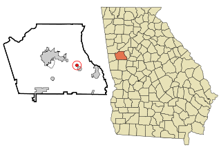
Sharpsburg (ˈʃɑrpsbɝg) is a town in Coweta County, Georgia, United States. It is part of the Atlanta metropolitan area. Its population was 327 at the 2020 census.

<span class="mw-page-title-main">Maryville, Illinois</span> Village in Illinois, United States

Maryville is a village in Madison County, Illinois, United States. The population was 8,221 at the 2020 census, up from 7,487 in 2010.

<span class="mw-page-title-main">Markleville, Indiana</span> Town in Indiana, United States

Markleville is a town in Adams Township, Madison County, Indiana, United States. It is part of the Indianapolis–Carmel–Anderson metropolitan statistical area. The population was 484 at the 2020 census.

<span class="mw-page-title-main">Center Point, Iowa</span> City in Iowa, United States

Center Point is a city in Linn County, Iowa, United States. The population was 2,579 at the 2020 census. It is part of the Cedar Rapids Metropolitan Statistical Area.

<span class="mw-page-title-main">Scandia, Minnesota</span> City in Minnesota, United States

Scandia is a city in Washington County, Minnesota, United States. The population was 3,984 at the 2020 census. Scandia is 25 miles northeast of Saint Paul, Minnesota.

<span class="mw-page-title-main">Altenburg, Missouri</span> City in Missouri, United States

Altenburg is a city in Perry County, Missouri, United States. The population was 341 at the 2020 census.

<span class="mw-page-title-main">Stratford, New Hampshire</span> Town in New Hampshire, United States

Stratford is a town located on the Connecticut River in Coös County, New Hampshire, United States. The population was 662 at the 2020 census, down from 746 at the 2010 census. Within the town are the villages of North Stratford, Stratford Hollow, and Beatties. U.S. Route 3 passes through the center of town, as does the St. Lawrence and Atlantic Railroad, formerly a part of the Grand Trunk Railway.

<span class="mw-page-title-main">Moline Acres, Missouri</span> City in Missouri, United States

Moline Acres is a city in St. Louis County, Missouri, United States. The population was 2,442 at the 2010 census.

<span class="mw-page-title-main">Eunice, New Mexico</span> City in New Mexico, United States

Eunice is a city in Lea County, New Mexico, United States. The population was 2,922 at the 2010 census.

<span class="mw-page-title-main">Bechtelsville, Pennsylvania</span> Borough in Pennsylvania, United States

Bechtelsville is a borough in Berks County, Pennsylvania, United States. The population was 942 at the 2010 census.

<span class="mw-page-title-main">North Hopewell Township, Pennsylvania</span> Township in Pennsylvania, United States

North Hopewell Township is a township that is located in York County, Pennsylvania, United States. The population was 2,723 at the time of the 2020 census.

<span class="mw-page-title-main">Hill Country Village, Texas</span> City in Texas, United States

Hill Country Village is a city in Bexar County, Texas, United States. The population was 942 at the 2020 census. It is a very affluent enclave city, home to old money families. It is part of the San Antonio Metropolitan Statistical Area. It is the 7th wealthiest location in Texas by per capita income.

<span class="mw-page-title-main">Garland, Utah</span> City in Utah, United States

Garland is a city in northeastern Box Elder County, Utah, United States. The population was 2,589 at the 2020 census.

<span class="mw-page-title-main">Ridgefield, Washington</span> City in Washington, United States

Ridgefield is a city in northern Clark County, Washington, United States. The population was 10,319 at the time of the 2020 census, up from 4,763 in 2010, making it the fastest growing city in the state of Washington.

<span class="mw-page-title-main">Raymond, Washington</span> City in Washington, United States

Raymond is a city in Pacific County, Washington, United States. The population was 2,882 at the 2010 census. The 2020 census showed the population of 3,081, an increase of 6.4%. The town's economy has traditionally been based on logging and fishing, together with a limited amount of tourism.

<span class="mw-page-title-main">Spangle, Washington</span> City in Washington, United States

Spangle is a city in Spokane County, Washington, United States. The population was 278 at the 2010 census. The name comes from William Spangle, an early pioneer.

<span class="mw-page-title-main">Zillah, Washington</span> City in Washington, United States

Zillah is a city in Yakima County, Washington, United States, with a population of 3,179 as of the 2020 census.

<span class="mw-page-title-main">Belmont, West Virginia</span> Town in West Virginia, United States

Belmont is a town in Pleasants County, West Virginia, United States. It is part of the Parkersburg–Vienna metropolitan area. The population was 872 at the 2020 census. Belmont was incorporated on April 19, 1946 by the Circuit Court of Pleasants County. The city was named for the beautiful hills in the area.

<span class="mw-page-title-main">Alma, Wisconsin</span> City in Wisconsin, United States

Alma is a city in and the county seat of Buffalo County, Wisconsin, United States. The population was 716 at the 2020 census.

<span class="mw-page-title-main">Omro, Wisconsin</span> City in Wisconsin, United States

Omro is a city in Winnebago County, Wisconsin, United States. The population was 3,517 at the 2010 census. The city is located along the Fox River, approximately 10 miles west of Oshkosh, Wisconsin.

References

  1. "US Gazetteer files: 2010, 2000, and 1990". United States Census Bureau. February 12, 2011. Retrieved April 23, 2011.
  2. "2021 U.S. Gazetteer Files". United States Census Bureau. Retrieved February 17, 2023.
  3. 1 2 3 "Explore Census Data". United States Census Bureau . Retrieved February 17, 2023.
  4. 1 2 "City and Town Population Totals: 2020-2021". United States Census Bureau. February 17, 2023. Retrieved February 17, 2023.
  5. "US Board on Geographic Names". United States Geological Survey. October 25, 2007. Retrieved January 31, 2008.
  6. Washington - A guide to the Evergreen State, WPA American Guide Series, Washington State Historical Society, 1941
  7. "US Gazetteer files 2010". United States Census Bureau. Archived from the original on January 25, 2012. Retrieved December 19, 2012.
  8. United States Census Bureau. "Census of Population and Housing" . Retrieved September 19, 2013.
  9. Barker, Cade (August 28, 2023). "Highland Lutheran Church to celebrate 140th anniversary". The Reflector. Retrieved September 20, 2023.