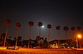
Pacific Beach is a neighborhood in San Diego, bounded by La Jolla to the north, Mission Beach and Mission Bay to the south, Interstate 5 and Clairemont to the east and the Pacific Ocean to the west. While formerly largely populated by young people, surfers, and college students, because of rising property and rental costs the population is gradually becoming older and more affluent. "P.B.," as it is known as by local residents, is home to one of San Diego's more developed nightlife scenes, with a great variety of bars, eateries, and clothing stores located along Garnet Avenue and Mission Boulevard.

Imperial Beach is a residential beach city in San Diego County, California, with a population of 26,137 at the 2020 United States census, down from 26,324 at the 2010 census. The city is the southernmost city in California and the West Coast of the United States. It is in the South Bay area of San Diego County, 14.1 miles (22.7 km) south of downtown San Diego and 5 miles (8 km) northwest of downtown Tijuana, Mexico.

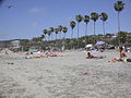
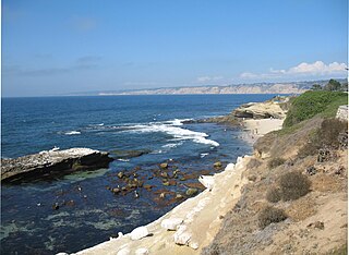
La Jolla is a hilly, seaside neighborhood within the city of San Diego, occupying 7 miles (11 km) of curving coastline along the Pacific Ocean. The population reported in the 2010 census was 46,781. The climate is mild, with an average daily temperature of 70.5 °F (21.4 °C).

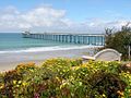
The Scripps Institution of Oceanography (SIO) is the center for oceanography and Earth science based at the University of California, San Diego. Its main campus is located in La Jolla, with additional facilities in Point Loma.

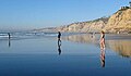
Black's Beach is a secluded section of beach beneath the bluffs of Torrey Pines on the Pacific Ocean in La Jolla, San Diego, California, United States. It is officially part of Torrey Pines State Beach. The northern portion of Black's Beach is owned and managed by the California Department of Parks and Recreation, while the southern portion of the beach, officially known as Torrey Pines City Beach, is jointly owned by the city of San Diego and the state park, but is managed by the city of San Diego. This distinction is important as Black's Beach is most known as a nude beach, a practice that is now prohibited in the southern portion managed by the city of San Diego.

SEALAB I, II, and III were experimental underwater habitats developed and deployed by the United States Navy during the 1960s to prove the viability of saturation diving and humans living in isolation for extended periods of time. The knowledge gained from the SEALAB expeditions helped advance the science of deep sea diving and rescue, and contributed to the understanding of the psychological and physiological strains humans can endure.

Scripps Canyon is a narrow underwater gorge located in the Pacific Ocean off the coast of southern California, United States. The canyon is approximately 1 mile (1.6 km) long and joins to La Jolla Canyon offshore.

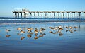
Birch Aquarium is an aquarium and the public outreach center for Scripps Institution of Oceanography at the University of California, San Diego. Accredited by the Association of Zoos and Aquariums, Birch Aquarium has an annual attendance of more than 439,000, including more than 40,000 school children, and features more than 3,000 animals representing 380 species. The hilltop site provides views of the Scripps Institution of Oceanography campus and the North Pacific Ocean. The mission of the aquarium reads: "As the public outreach center for Scripps Institution of Oceanography at UC San Diego, Birch Aquarium features the groundbreaking work of Scripps Oceanography and UC San Diego scientists through innovative exhibits and events. More than just an aquarium, Birch Aquarium offers hands-on learning opportunities and climate-based programming to 40,000-plus K-12 students each year on site, in schools and in the field.".
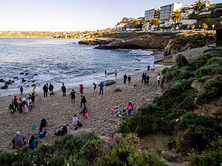
La Jolla Cove is a small cove with a beach that is surrounded by cliffs in La Jolla, San Diego, California. Point La Jolla forms the south side of the cove. The area is protected as part of a marine reserve and is popular with snorkelers, swimmers and scuba divers.
The San Diego-La Jolla Underwater Park is the historical name for a marine reserve that includes the San Diego-Scripps Coastal Marine Conservation Area (SMCA) and Matlahuayl State Marine Reserve (SMR), adjoining marine protected areas that extend offshore from La Jolla in San Diego County on California's south coast.

The Old Scripps Building is a historic research facility on the campus of the University of California, San Diego in La Jolla, California. Built in 1909-10, it is the oldest oceanographic research building in continuous use in the United States and the historic center of the Scripps Institution of Oceanography. It is also architecturally significant as a work of Modernist architect Irving Gill and for its early use of reinforced concrete. It was declared a National Historic Landmark in 1982. It now houses Scripps administrative offices.
Douglas Lamar Inman was a Professor of Oceanography at the Scripps Institution of Oceanography.

San Diego-Scripps Coastal Marine Conservation Area (SMCA) and Matlahuayl State Marine Reserve (SMR) are adjoining marine protected areas that extend offshore from La Jolla in San Diego County on California's south coast. The two marine protected areas cover 2.51 square miles (6.5 km2). San Diego-Scripps Coastal SMCA prohibits the take of all living marine resources except that coastal pelagic species, not including market squid, may be taken recreationally by hook and line. Matlahuayl SMR prohibits the take of all living marine resources.
South La Jolla State Marine Conservation Area (SMCA) and South La Jolla State Marine Reserve (SMR) are two adjoining marine protected areas that extend offshore in San Diego County on California's south coast. The two marine protected areas cover 7.51 square miles (19.5 km2). The SMR protects marine life by prohibiting the removal of marine wildlife from within its borders, while the SMCA limits removal of marine wildlife.
San Lucas Canyon is a submarine canyon off Cabo San Lucas, Baja California Sur. The canyon is home to some spectacular submarine phenomena, namely the "rivers of sand" and sandfalls. These were first observed in 1959 by an expedition led by D. F. Shepard and including Conrad Limbaugh, James Steward, and Wheeler J. North. These features were documented by Robert F. Dill (1964) and dived, filmed and made famous by Jacques Cousteau.
Shell Beach, La Jolla is a small beach in La Jolla, a community of San Diego, California, United States. The beach is accessed via a flight of concrete steps that start at the south end of Ellen Browning Scripps Park. This beach is located immediately north of Children's Pool Beach, south of Boomer Beach, and also south of La Jolla Cove.
The Scripps Formation is a geologic formation in coastal San Diego County, California.

Scripps Coastal Reserve is a 126-acre University of California Natural Reserve System reserve located west of UC San Diego in the La Jolla Farms area of La Jolla, California. Administered by UC San Diego, the site is owned by the University of California and managed for teaching and research.
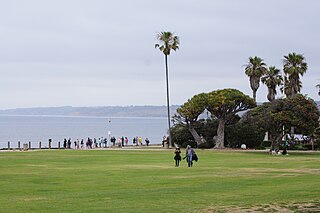
Ellen Browning Scripps Memorial Park, often referred to as Scripps Park, is an urban park located in La Jolla within the city of San Diego, California. The 5.6 acres (2.3 ha) park, part of the unceded ancient homeland and traditional territory of the Kumeyaay Nation, is sited on a sandstone bluff overlooking the Pacific Ocean. It is an open-space, landscaped environment heavily used by residents and visitors from all over the world.