Ladykirk and Norham Bridge

Last updated

Ladykirk and Norham Bridge
Bridge over River Tweed at Norham - geograph.org.uk - 139198.jpg
Coordinates 55°43′08″N2°10′34″W / 55.719°N 2.176°W / 55.719; -2.176 Coordinates: 55°43′08″N2°10′34″W / 55.719°N 2.176°W / 55.719; -2.176
CarriesRoad traffic (single carriageway)
Crosses River Tweed
Locale Norham in Northumberland, England/
Ladykirk, Borders, Scotland
Characteristics
MaterialStone
No. of spans4
History
Designer Thomas Codrington
and Cuthbert A. Brereton
Construction start1885
Construction end1887
Statistics
TollNo
Location
Ladykirk and Norham Bridge

The Ladykirk and Norham Bridge connects Ladykirk in the Borders, Scotland, with Norham in Northumberland, England, across the River Tweed. It's one of three bridges that cross it along the Anglo-Scottish Border, the others being the Coldstream Bridge and the Union Chain Bridge; out of these, the Ladykirk and Norham Bridge is the youngest, opening to the public in 1888.

Contents

Earlier bridges

The previous bridge was a timber trestle built between 1838 and 1839 by J. Blackmore. [1] [2] The bridge was funded by subscribers purchasing shares; David Robertson, 1st Baron Marjoribanks paid L.3000, and ten others paid L.500 each. [3]

This bridge used curved ribs eight planks deep at the ends and three planks deep in the middle, where each individual plank is 6 inches (150 mm) deep. [4] These were used to create two arches, each of 190 feet (58 m) span and 17 feet (5.2 m) rise, each arch was supported by two trusses. [4] The planks were 18 feet (5.5 m) long, and no piece of timber in the bridge was longer than 28 feet (8.5 m). [4] The roadway was 18 feet (5.5 m) wide. [4] The entire bridge was restored in 1852, with the exception of the stone piers. [3]

History

Construction of the present stone bridge lasted from 1885 to 1887. [1] The bridge is listed at grade II by English Heritage and at category B by Historic Scotland. [1] [5]

It was designed by Thomas Codrington and Cuthbert A. Brereton for the Tweed Bridges Trust. [5]

Design

It is a late stone road arch bridge with four spans. [5] The two middle arches are of 90 feet (27 m) span, and the outer two of 85 feet (26 m) span, and the width of the roadway between the parapets is 14 feet (4.3 m). [5] The outer piers have triangular cutwaters, but the central pier has a curved cutwater that continues up to the height of the road, with a break in the parapet to create a refuge for pedestrians. [6]

The bridge uses dressed-stone for the arch rings, and has coursed-rubble spandrels and wing walls. [6] It is built from red sandstone, and faced with ashlar dressings. [1] The spandrels are hollow to reduce the load on the arches, an innovation by Thomas Telford. [1] [7]

The bridge carries the B6470 public road between the villages of Ladykirk in Scotland and Norham in England. [1] It is just downstream from Canny Island, a river island in the Tweed. [8]

Canny Island, viewed from Ladykirk and Norham Bridge. Canny Island and the Tweed - geograph.org.uk - 503445.jpg
Canny Island, viewed from Ladykirk and Norham Bridge.

Related Research Articles

Norham Human settlement in England

Norham is a village and civil parish in Northumberland, England, It is located 7 miles (11 km) south-west of Berwick on the south side of the River Tweed where it is the border with Scotland.

Key Bridge (Washington, D.C.) United States historic place

The Francis Scott Key Bridge, more commonly known as the Key Bridge, is a six-lane reinforced concrete arch bridge conveying U.S. Route 29 (US 29) traffic across the Potomac River between the Rosslyn neighborhood of Arlington County, Virginia, and the Georgetown neighborhood of Washington, D.C. Completed in 1923, it is Washington's oldest surviving road bridge across the Potomac River.

<span class="mw-page-title-main">Union Chain Bridge</span> Bridge

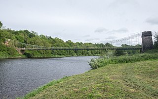
The Union Chain Bridge or Union Bridge is a suspension bridge that spans the River Tweed between Horncliffe, Northumberland, England and Fishwick, Berwickshire, Scotland. It is four miles upstream of Berwick-upon-Tweed. When it opened in 1820 it was the longest wrought iron suspension bridge in the world with a span of 449 feet (137 m), and the first vehicular bridge of its type in the United Kingdom. Although work started on the Menai Suspension Bridge first, the Union Bridge was completed earlier. Today it is the oldest suspension bridge still carrying road traffic and is a Category A listed building in Scotland, a Grade I listed building in England and an International Historic Civil Engineering Landmark. It lies on Sustrans Route 1 and the Pennine Cycleway.

<span class="mw-page-title-main">Berwick Bridge</span> Bridge in Northumberland

Berwick Bridge, also known as the Old Bridge, spans the River Tweed in Berwick-upon-Tweed, Northumberland, England. The current structure is a Grade I listed stone bridge built between 1611 and 1624.

<span class="mw-page-title-main">Coldstream Bridge</span> Bridge in Scottish Borders, Scotland

Coldstream Bridge, linking Coldstream, Scottish Borders with Cornhill-on-Tweed, Northumberland, is an 18th-century Category A/Grade II* listed bridge between England and Scotland, across the River Tweed. The bridge carries the A697 road across the Tweed.

<span class="mw-page-title-main">Royal Tweed Bridge</span> Bridge in Northumberland

The Royal Tweed Bridge is a road bridge in Berwick-upon-Tweed, Northumberland, England crossing the River Tweed. It was intended to divert traffic from the 17th century Berwick Bridge, and until the 1980s it formed part of the A1 road, the main route from London to Edinburgh. However, the construction of the A1 River Tweed Bridge to the west of Berwick has since reduced the Royal Tweed Bridge's importance.

Slateford Aqueduct Bridge in Slateford

The Slateford Aqueduct is a navigable aqueduct that carries the Union Canal over the Water of Leith at Slateford, Edinburgh, Scotland. Completed in 1822, it has eight arches and spans a length of 500 feet (150 m).

<span class="mw-page-title-main">Leaderfoot Viaduct</span> Bridge

The Leaderfoot Viaduct, also known as the Drygrange Viaduct, is a railway viaduct over the River Tweed near Melrose in the Scottish Borders.

<span class="mw-page-title-main">Pont sur la Laye</span> Bridge in Alpes-de-Haute-Provence, France

The Pont sur la Laye or Pont roman de Mane is an old stone arch bridge across the stream Laye in the French Provence close to the town Mane.

<span class="mw-page-title-main">Tweed Bridge</span> Bridge

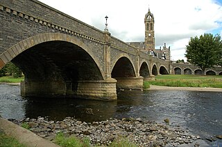
The Tweed Bridge is a stone-built road bridge of five spans over the River Tweed in Peebles, in the Scottish Borders.

Lyne Viaduct Bridge in Lyne, Borders

Lyne Viaduct is a viaduct at Lyne in the Scottish Borders of Scotland. It consists of three stone skew arches and a plate girder approach span over a minor road and was built to carry the Symington to Peebles branch line of the Caledonian Railway over Lyne Water to the west of Peebles. Now closed to rail traffic the bridge is used as a footpath.

<span class="mw-page-title-main">River Irwell Railway Bridge</span> Bridge in Manchester, England

The River Irwell Railway Bridge was built for the Liverpool & Manchester Railway (L&MR), the world's first passenger railway which used only steam locomotives and operated as a scheduled service, near Water Street in Manchester, England. The stone railway bridge, built in 1830 by George Stephenson, was part of Liverpool Road railway station. The bridge was designated a Grade I listed building on 20 June 1988.

<span class="mw-page-title-main">Yair Bridge</span> Bridge

The Yair Bridge or Fairnilee Bridge is a bridge across the River Tweed at Yair, near Galashiels in the Scottish Borders.

<span class="mw-page-title-main">Skerton Bridge</span> Bridge in Lancashire, England

Skerton Bridge is a road bridge carrying the southbound lanes of the A6 road over the River Lune in Lancaster, Lancashire, England. The bridge is recorded in the National Heritage List for England as a designated Grade II* listed building and Scheduled Monument.

<span class="mw-page-title-main">Newbattle Viaduct</span> Railway bridge in Midlothian, Scotland, UK

The Newbattle Viaduct, sometimes also called the Lothianbridge, Newtongrange or Dalhousie Viaduct, carries the Borders Railway, which opened in 2015, over the River South Esk near Newtongrange, Midlothian, Scotland.

<span class="mw-page-title-main">Drygrange Old Bridge</span> Bridge

The Drygrange Old Bridge is a disused road bridge over the River Tweed near Melrose in the Scottish Borders.

<span class="mw-page-title-main">Kelso Bridge</span> Bridge

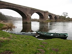
The Kelso Bridge or Rennie's Bridge is a bridge across the River Tweed at Kelso, in the Scottish Borders.

<span class="mw-page-title-main">Mertoun Bridge</span> Bridge

The Mertoun Bridge is a bridge across the River Tweed in the Scottish Borders.

<span class="mw-page-title-main">West Sixth Street Bridge</span> Historic bridge in Austin, Texas

The West Sixth Street Bridge is a historic stone arch bridge in downtown Austin, Texas. Built in 1887, the bridge is one of the state's oldest masonry arch bridges. It is located at the site of the first bridge in Austin, carrying Sixth Street across Shoal Creek to link the western and central parts of the old city. The bridge was added to the National Register of Historic Places in 2014.

<span class="mw-page-title-main">Monks Bridge, River Dove</span> Bridge in Staffordshire/Egginton, Derbyshire

Monks Bridge is a road bridge across the River Dove between Stretton, Staffordshire, and Egginton, Derbyshire. A bridge has existed here since the early 13th century, though much of the current structure dates to the 15th century. It formerly carried traffic on what is now the A38 road but a replacement structure was built to the north in 1926. It was formerly used as a slip road but is now out of use to vehicular traffic.

References

  1. 1 2 3 4 5 6 "Ladykirk And Norham Bridge". rcahms.gov.uk. Retrieved 9 September 2014.
  2. "Ladykirk and Norham Bridge". bridgesonthetyne.co.uk. Retrieved 10 September 2014.
  3. 1 2 Report of the Commissioners for Inquiring into Matters Relating to Public Roads in Scotland. Murray and Gibb. 1859. p. 132.
  4. 1 2 3 4 Warr, George Finden (1851). Dynamics, Construction of Machinery, Equilibrium of Structures and the Strength of Materials. Robert Baldwin. pp. 176–177.
  5. 1 2 3 4 "Ladykirk and Norham Bridge". sine.ncl.ac.uk. Archived from the original on 17 July 2012. Retrieved 9 September 2014.
  6. 1 2 "Historic Border Bridges". ice.org.uk. Retrieved 10 September 2014.
  7. "Ashford Carbonell Bridge". engineering-timelines.com. Archived from the original on 2 April 2015. Retrieved 10 September 2014.
  8. Google (9 September 2014). "Ladykirk and Norham Bridge" (Map). Google Maps . Google. Retrieved 9 September 2014.